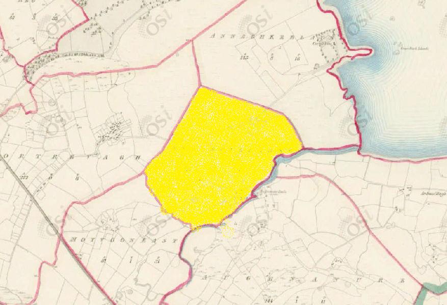
Knockillaree
Townlands of Oughterard
By Paul Gibbons

Anglicized from Irish: Cnoc Chill an Fhraoigh / Cnoc Chill an Rí
Translates to: “Hill of the church of the heath” / “Hill of the church of the king”
Etymology:
The townland is small and has a low rounded hillock to its centre. Although there are no remains of a church in the area, nor is one present on the OSI 6-inch maps, there are some local sources which suggest that a church did exist here in medieval times and when it stopped being used/when it was destroyed a new church was built in Laghtgannon (Killaroon Church). At this point it should be said that there are two possible translations for this placename. The first, “hill of the church of the heath” comes from the Irish Cnoc Chill an Fhraoigh. The fact that a lot of the townland is bog would lend credit to this name as heather is prevalent in peatland. However, the other translation, “hill of the church of the king” from the Irish Cnoc Chill an Rí, is also possible. Knockillaree is located to the north of Aughnanure with the O’Flaherty castle lying at the border between the two. Because of the importance of religion in Irish medieval society it would be likely that a church was built near the castle to serve the local chieftain/king hence the etymology of the name. It should also be noted that in Irish medieval society the term Rí although translated as King was used to denote leaders of different levels of power from local (rí túaithe), regional (ruirí & rí ruirech), and provincial (rí cóicid) to national (ard rí).
Size: 90 acres, 2 rods, 19 perchs
Siting:
In the northern extremity of Kilcummin parish. Bounded on the north-east by Annaghkeelaun, on the north-west by Gortrevagh, on the south by Moyvoon East and Aughnanure, and on the east by Ardnasillagh.
Description:
Contains 90 and a half acres of land about half of which is under tillage and pasture, the remainder is bog.
Placenames within townland:
N/A
Previous proprietor/landlord:
Teige O’Flahertye (1641)
Murrogh McDunnogh (1641)
Richard Martin (1670)
James O’Hara of Leanaboy House (c. 1850)
Land Value (1857): £ 25 s.5 d. 0
Buildings Value (1857): £ 2 s.0 d. 0
Surnames attached to the townland (1857-1911):
O’Hara, Gorman, Dunne, McDonagh, Cottingham, Welby, Walsh, Joyce


No Comments
Add a comment about this page