Barrusheen
Townlands of Oughterard
By Paul Gibbons

Anglicized from Irish: Barr Roisín
Translates to: “Top of the little point/penninsula”
Etymology:
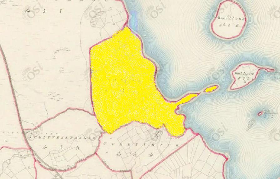
Barrusheen consists of an area of land with a small (yet prominent) point/penninsula towards the south of the townland which juts out into Lough Corrib. This area of land would most likely have been of importance allowing for easier access to the two small islands (an unnamed island and Inishdauwee Island) further out in the lake which contained cultivated land. This point/penninsula would have also marked the townland out from the surrounding area and hence lead to the creation of a distinctive placename.
Size: 114 acres , 3 rods , 11 perchs
Siting:
Situated in the northern extremity of Kilcummin parish. Bounded on the north-west by Derreenmeel, on the east by Lough Corrib, on the west by Tullyvealnaslee and on the south by Tullyvrick townland.
Description:
Bad land quality, often heathy and swampy. Contains 114¾ acres, about 30 acres are under tillage and pasture (with land by the shores of Lough Corrib liable to flooding), the remainder is made up of rough bogland. Lough Corrib forms the eastern boundary of the townland.
Placenames within townland:
Inishdauwee (island) – Contains 9½ acres all under tillage and pasture. It is situated west of Illaunnacreeva island and north-west of Creeve Island.
Previous proprietor/landlord:
Richard Martin (1670)
Earl of Clanrickard (1670)
Thomas B. Martin of Ballinahinch Castle (c. 1850)
Land Value (1857): £ 14 s. 4 d. 0
Buildings Value (1857): £ 0 s. 0 d. 0
Surnames attached to the townland (1857-1911):
Molloy, McGauley, Melia, Faherty, Kelly, Connor, Joyce


No Comments
Add a comment about this page