
Anglicized from Irish: An Chreig
Translates to: “The Rocky Ground”
Etymology:
Cregg has an area of some 400 acres, just over a quarter of which could be used for tillage/pasture as the rest was either plantation, bog or rocky pasture. With such a large proportion of the townland being rocky, unproductive ground it makes sense that this description was used to refer to the townland. The village of Cregg was also situated on some of this rocky pasture ground most likely to leave the arable land for the production of food. This means that the main focus of the townland was on the rocky ground where the people resided.
Size:400 acres, 2 rods, 15 perchs
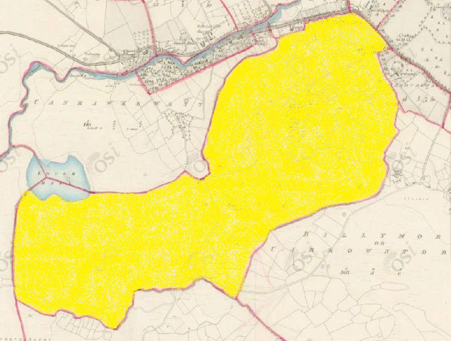
Siting:
In the eastern extremity of Kilcummin parish. Bounded on the north by Fough East and West (the town of Oughterard itself), on the east by Lemonfield, Ardvarna and Billymore/Carrowntobar, on the west by Canrawer West and Rusheeny and on the south by Clooshgereen.
Description:
Land very bad, contains 394 and a half acres of land, about 120 are under tillage and pasture, the remainder is plantation, bog and rocky pasture. The centre of the Galway to Oughterard road form the northern boundary. There is a village situated in the centre part of this townland, a cave and fort near its eastern boundary and a pool called Pollboy near Oughterard town.
Placenames within townland:
Pollboy (hole/pond) – Most likely translates to ‘yellow hole’. Once located where the Bank of Ireland building stands today.
Lough Mall (lake) – Translates to ‘the lake of the knoll’.
Mine (lead) – On southern boundary of townland at the base of Corkernarusheeny hill. Judging from the limited material available it is a continuation of the Glengowla mineralization. The site has been bulldozed several decades ago and no visible surface trace remains.
Vernacular House – A house which is non-formal, built of local materials using local skills and craftsmen within the parameters of their own local building tradition. In Ireland the majority are single storey, rectangular in plan and only one room deep, with a main hearth/kitchen forming the core of the house for domestic and social activities. These date from the 17th to the early 20th century AD.
Ringfort – In an area of undulating pasturland. Poorly preserved sub-circular cashel (diameter c. 22-25m) defined by a much collapsed drystone wall, overlain at west by a modern field wall. A children’s burial ground occupies the interior.
Children’s Burial Ground (arch. remains) – Within a ringfort. All that is visible is a number of small set stones in south-east quadrant.
Enclosure (arch. remains) – Within a hazel thicket in pastureland. Poorly preserved and overgrown irregular enclosure (diameter c. 20m) forming a keyhole shape on plan. Defined by a drystone wall, best preserved at south west, a modern field wall overlies the enclosing element elsewhere. The interior contains a souterrain.
Souterrain (arch. remains) – Within south half of enclosure. A drystone built passge can be traced running north-east to south-west. Present access is at south west end via a modern breach but the passage is inaccessible.
Previous proprietor/landlord:
Captain O’Flaherty of Lemonfield (c. 1850)
Land Value (1857): £54 s.7 d.0
Building Value (1857): £121 s.17 d.0
Surnames attached to the townland (1857-1911):
Naughton, Walsh, Tierney, Gill, Lydon, Meally, Linskey, Flaherty, Guilfoyle, Newell


No Comments
Add a comment about this page