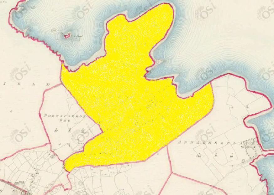
Portacarron
Townlands of Oughterard
By Paul Gibbons

Anglicized from Irish: Port an Chairrín/Port an Carron
Translates to: “Landing place of Cairrín (personal name)” or “Landing place of the cairn”
Etymology:
Portacarron is situated on the shores of Lough Corrib and seems to have been used as a port or landing place since early times. The townland contains an inlet which is sheltered by land on both sides. The official placename seems to refer to the personal name Cairrín as either a possible owner of the area or a regular arriver to the port. Another possible translation could be “landing place of the cairn (monumental heap of stones)”. This is possible as there is a mound located in the townland which seems to be part of an Early Christian ecclesiastical complex. The artificial mound which is now covered in earth may have existed as a simple mound of stones until it was covered over later on.
Size: 233 acres, 2 rods, 37 perchs
Siting:
Situated in the northern extremity of Kilcummin parish. Bounded on the north by Lough Corrib, on the south-east by Annaghkeelann, on the west by Lemonfield, Portacarronbeg and Rushveala and on the south by Gortrevagh townland.
Description:
Land very good. Contains 233 and three quarter acres, 120 acres under tillage and pasture, the remainder is bog with a few patches of plantation and brushwood. Portacarron House is situated in the northern part of this townland, along with an old mound with ecclesiastical ruins forms part of the shore of Lough Corrib.
Placenames within townland:
Cossafoor Island – Translates to ‘cold feet island’. Contains 1 and a quarter acres, all under rough pasture and brushwood. It is situated north of Innishhool and south-east of Urkannbeg Island.
Inishbeagh Island – Translates to ‘island of birch trees’. Contains 4 acres, all under tillage with a few scattered bushes. Situated just off Bilberry Island.
Ecclesiastical Enclosure – Close to west shore of Lough Corrib. A large oval enclosure (E-W 94.6m, N-S 65.2m) defined by an earth and stone bank best preserved at south but disturbed elsewhere by farm buildings and modern walls.
Enclosure –An area defined by an enclosing element (e.g. bank, wall, fosse, scarp). These may date to any period from prehistory onwards. Part of the complex of ecclesiastical structures in the north of the townland.
Church – In south half of early ecclesiastical enclosure. Small, much ruined early Christian oratory. No architectural features are visible nor is there any trace of doorway previosuly noted in the west wall.
Mound – An artificial elevation of earth or earth and stone of unknown date and function which cannot be classified as any other known archaeological monument type on present evidence.
Previous proprietor/landlord:
Peter D’arcy (1641)
Sir George Bingham (1670)
John Nolan of Ballinderry, Co. Galway (c. 1850)
Land Value (1857): £ 76 s.10 d. 0
Buildings Value (1857): £ 5 s.16 d. 0
Surnames attached to the townland (1857-1911):
Mealy, Small, Healy, Fahy, Gorman, Clancy, Hacket, Connor, Kinneavy, Walsh


Comments about this page
Newspaper: Pue’s Occurrence of December 1749 carried a notice dated 2nd December 1749 from James French of “Portacarrine”, Co. Galway in relation to the death of Pat. French, Merchant late of Galway.
He was the administrator of Pat. French’s estate.
Credits: http://www.britishnewspaperarchives.co.uk
Possible translation of place name- Port a’ ceathrún “The landing place (port) of the quarter”. In my opinion Port a Cairrín is extremely doubtful and it’s place on signposts is not proven.
Add a comment about this page