Lemonfield
Townlands of Oughterard
By Paul Gibbons

Anglicized from Irish: An Chorr / Páirc Leamhán
Translates to: “The rounded hill” / “Field of the Elms”
Etymology:
This townland has had various names throughout its history. It seems to have first been referred to as An Chorr meaning ‘the rounded hill’. This could be a reference to Knocknacoura near the shores of Lough Corrib. However, on the OSI maps the remains of a rounded boundary can be seen to the east of the old site of Lemonfield House. This is a slightly elevated area with low lying bogland to its east.
The present name Lemonfield has two possible origins. The first could be a corruption of the Irish ‘Páirc Leamhán’ meaning field of the elms because the word leamhán is pronounced similar to the word lemon. However, the most widely known origin story for Lemonfield is a folktale about the O’Fflahertie family who had there seat in the area. It is said that upon moving to the area from Aughnanure Castle in the mid 18th century Mr. O’Fflahertie decided to plant numerous lemon trees about his estate. Unfortunately, given Ireland’s lack of sunshine the trees never produced fruit yet the name and O’Fflahertie’s attempts lived on. Although this story is possible it could also be a case of the corruption of a placename giving rise to a story.
Size: 388 acres, 2 rods, 30 perchs
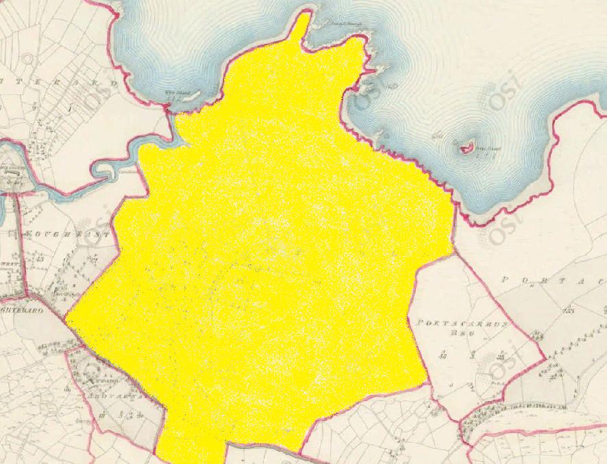
Siting:
Situated in the northern extremity of Kilcummin parish. Bounded on the north by Lough Corrib, on the east by Portacarron, Portacarronbeg, and Rushveela, on the west by Eighterard, Fough East and Cregg and on the south by Ardvarna, Billymore and Glebe.
Description:
Land very good and free from rocks or mountains. Contains 371 and a quarter acres, about 90 acres are under tillage and pasture, the remainder is plantation, bog and rough pasture. Lemonfield House, the residence of Capt. O’Flaherty is situated in the eastern extremity of the townland. St. Cummin’s Well is in its southern extremity, also Kilcummin Old Church ruins and graveyard marks its southern boundary. The Galway to Oughterard road passes through it and there was a quarry close to its southern boundary.
Placenames within townland:
Annaghclooagh (bog) – Translates to ‘feathered/fluffy marsh’. O’Donovan’s Field Name Book describes the area as: a bog where a sedgy species with white tops/tufts grow. This most likely refers to bog cotton which is a sedge with a fluffy/feathering look and texture.
Biberry Island – From the Irish ‘oileán na bhfraochóg’. Remarkable for the number of Bilberry trees which grow there. Contains 2¼ acres all covered with brushwood and it is situated north-west of Urkaunmore and west of Innishbeagh.
Bronteeen Island – Translates to ‘island of the quern/mill stone. Contains 1½ acres all rough pasture, and is situated north-west of Innishshanvo and south of Bilberry Island.
Geese Island – Contains a quarter acre of dry pasture. There is a rock on north-west side containing a quarter of an acre – situate north-east of Lemonfield.
Illaunnacreeva – Translates to ‘island of the bush/branchy tree’. An island remarkable for a lone bush in it from whence it takes its name. Contains 1 and a half chains of rough pasture but is principally rock which cannot be seen at high water. There is a large rock containing half an acre situated to the south of it.
Kilcomine/Kilcummin (field) – Translates to ‘St. Cummin’s Church’. A large field, having a ruin of Chapel and Burial Ground in it. Modern day graveyard.
Knocknacoura (hill) – Translates to ‘hill of the help’ also known as ‘relief hill’. A very high point commanding a view of the lake. It has a Triangulation Station on it.
River Island – Contains ½ acre of rough pasture. Situated in the mouth of the Fough/Owenriff River. A mesolithic flint flake was found at this site and was most likely used as a fish spear by early hunter-gatherers.
St. Cummin’s Well – A holy well famed for stations on the 14th of October and the last Sunday of July. To the south of the Oughterard-Galway road c. 290 m west-south-west of a church.
Designed landscape – A man-made feature that is laid out to produce the effect of natural scenery, or other features, usually within demesnes and associated with a country house. These date from the 17th to the 19th century AD. Located on the border between Lemonfield and Ardvarna. No visible trace remains today.
St Cummin’s Church and Graveyard – On a small ridge overlooking Lough Corrib to the north-east. The remains comprise a medieval church with later south transept and a surrounding graveyard.
Previous proprietor/landlord:
Francis Blake (1641)
Francis Matthews (1670)
Captain O’Flaherty of Lemonfield (c. 1850)
Land Value (1857): £ 93 s.15 d. 0
Buildings Value (1857): £ 24 s.10 d. 0
Surnames attached to the townland (1857-1911):
O’Fflahertie, Lynn, Gavin, Gallagher, Fahy, Halloran, Moloney, Kay, Scoones


No Comments
Add a comment about this page