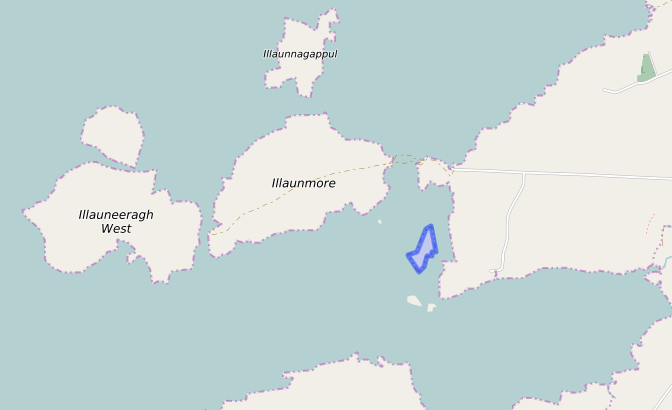
Roeillaun (off the coast of Kilbreckan)
Antoinette Lydon


Roeillaun is in the civil parish of Kilcummin. The civil Parish corresponds with the following Church of Ireland parish of Kilcummin, Galway West. In general, the civil parish and the Church of Ireland parish are the same as is the case in the Kilcummin Oughterard area.
Irish Form of Name: Ruadh Oileán
Translation: red island
Civil Parish: Kilcummin
View all place names in this civil parish.
Roeillaun is in the Electoral Division of Turlough, in Civil Parish of Kilcummin, in the Barony of Moycullen, in the County of Galway
Other Forms of the Name with authority source (if provided) in italics:
Roeillaun
Ruadh Oileán
Rooaillaun Boundary Surveyor
Ruillaunane County Map
Rooaillaun or Red Island Local
Description:
Contains 3¼ acres of rough pasture. Situated S.E. of Illaunmore and W. of Kibricken townland to which it belongs.
Situation:
In the sea. It belongs to the townland of Kilbricken.
Landlord
The landlord was Thomas B. Martin, Esq., Ballinahinch. Thomas B. Martin was a member of the Martin of Ross Family as stated in the Landed Estates Database.
- Martin (Ross) – The Martin family were established beside Ross Lake in the barony of Moycullen, county Galway, from the late 16th century, where they purchased land from the O’Flaherty’s. They were Royalist supporters and were dispossessed of their property in the city of Galway by the Cromwellians. Robert Martin received a grant of 2,909 acres in the barony of Moycullen, by patent dated 21 Aug 1677. Jasper Martin of Ross, who died in 1700, had two sons Jasper and Richard, from whom descend the two branches of the family settled at Ross and Ballynahinch. Nicholas Martin, who died in 1811, married Elizabeth O’Hara, daughter of Robert O’Hara of Lenaboy, and according to Burke’s” Landed Gentry”, a grandniece of James O’Hara, 2nd Baron Tyrawley. Their grandson, James Martin of Ross, had sixteen children from his two marriages. His daughter, Maud, married H. Callwell and they were the parents of the author, J. M. Callwell. The youngest daughter of James Martin was Violet Florence Martin of the well-known literary team Somerville and Ross. The Martins of Ross owned 5,767 acres in county Galway in the 1870s. They advertised the sale of their estate in the Landed Estates’ Court in May 1885.
- Martin (Ballynahinch) – A branch of the Anglo Norman family of Martin, one of the Tribes of Galway, was granted the O’Flaherty lands in the Connemara region in the mid-17th century. This family were a junior branch of the Martins of Ross and under the Acts of Settlement were granted vast estates in counties Galway, Mayo, Roscommon, Clare and Sligo. By a patent dated 1698 they were confirmed in the possession of their Connemara estate known as the Manor of Claremount by King William. The Westport Estate Papers document the sale of over 27,000 acres in the baronies of Moycullen and Ballynahinch by the trustees for the sale of Colonel John Browne’s estate to John Edwards for Richard Martin in 1699. The early generations of Martins lived at Birch Hall and Dangan, in the townland of Oranhill, parish of Rahoon, near Galway city. Richard Martin, better known as ‘Humanity Dick’, was the first member of the family to be reared as a Protestant. He was a famous duelist and founded the Society for the Prevention of Cruelty to Animals. Ballynahinch Castle was built in the center of his estate. His son Thomas Martin died in 1847 during the Famine and Thomas’s only daughter and heir, Mary Laetitia, inherited a heavily encumbered estate. She married her cousin, Arthur Gonne Bell, and died in New York in 1850. The Martin estates were offered for sale in two sections in 1849. Their property close to Galway town included Dangan, Corcullen, Bushypark and Killeen. Their Connemara estate was acquired by the Law Life Assurance Society in 1852, to whom it was heavily mortgaged. In 1853 the estate of almost 200,000 acres was surveyed by Thomas Colville Scott for a prospective buyer. Richard Martin, second son of Richard ‘Humanity Dick’ Martin of Ballynahinch, is recorded as holding five townlands in the parish of Killannin, barony of Moycullen, county Galway, at the time of Griffith’s Valuation although he emigrated to Canada in 1833. He was also recorded as the occupier of Clareville, a Martin home in the village of Oughterard. Many of his descendants still reside in Canada. http://www.martinhistory.net/
Information from the Down Survey Website.
The Down Survey is a mapped survey. Using the Civil Survey as a guide, teams of surveyors, mainly former soldiers, were sent out under Petty’s direction to measure every townland to be forfeited to soldiers and adventurers. The resulting maps, made at a scale of 40 perches to one inch (the modern equivalent of 1: 50,000), were the first systematic mapping of a large area on such a scale attempted anywhere. The primary purpose of these maps was to record the boundaries of each townland and to calculate their areas with great precision. The maps are also rich in other detail showing churches, roads, rivers, castles, houses and fortifications. Most towns are represented pictorially and the cartouches, the decorative titles, of each map in many cases reflect a specific characteristic of each barony. (http://downsurvey.tcd.ie)
No information available.
The Tithe Applotment Books
About the Records
Tithes were a tax on agricultural produce which was payable by the occupiers of agricultural land. They were the main source of income for the parish clergy of the Church of Ireland (the largest Protestant church and the church established by law). However, in many parishes a large part of the tithes was ‘appropriate’, which meant that they were payable to a bishop, cathedral chapter or another ecclesiastical recipient, or were ‘impropriate’, which generally meant that they were payable to a local landowner. The parishes used in the Tithe Applotment Books are civil or Church of Ireland parishes, which often differ in name and territory from Catholic parishes, Acts of Parliament of 1823 and 1832 provided for the conversion of tithes into a fixed charge on land, and specified the average price of wheat or oats in the parish in the seven years before 1821 as the basis on which the tithes would be calculated. They also extended the application of tithes to pasture, where previously they had been levied only on tillage.
This change in the law resulted in the valuation of individual holdings in almost all parishes containing agricultural land, in order to assess the portion of the tithes for which each occupier of land would be liable. The apportionment was recorded for each Church of Ireland parish in a Tithe Composition Applotment Book. The information was collected and the amounts were calculated by two Parochial Commissioners, one of whom was appointed by the cess-payers of the parish and the other by the relevant Diocese of the Church of Ireland. This procedure was carried out in over 2,500 parishes between the years 1823 and 1837.
The Tithe Applotment Books are in a variety of formats, from a few pages sewn together to elaborately bound volumes. In most cases they are written in manuscript throughout, although some consist of manuscript entries on printed questionnaires. The information in the books is broadly uniform and generally includes at least the name of occupier; the size of holding, the valuation and the tithe payable. In some cases, more detailed information is provided. Some volumes have maps and most have certificates and correspondence attached.
The sub-divisions of the parish were recorded. Some of these subdivisions, such as plough lands, ceased to be in official use after the six-inch survey of the Ordnance Survey was completed in the 1840s. Only productive land was subject to tithe, and the books usually distinguish between this tithable land and untithable land such as roads or mountains. Tithable land was in some cases classified by quality, and a money value was given to each class. In some cases, the proportion of tithe payable to the rector, vicar or lay proprietor of the tithes was set out. The column for observations was sometimes completed, with information about commonage, for example.
There are a number of other points that should be noted. The acreages given in the Tithe Applotment Books are in Irish or Plantation measure, which is 1.62 times larger than statute measure. Only occupiers of land at the time of the tithe composition are recorded, so not all heads of households living in a parish at the time are included. Only rural areas are systematically covered, although inhabitants of towns who held plots of cultivable land are included. The equivalent tax in urban areas, Minister’s Money, has left few records.
The Tithe Applotment Books are an important source of information for a wide variety of researchers of pre-Famine Ireland. They provide the first surviving national list of the occupiers of land, and are used by genealogists as a partial substitute for returns of the 1821 and 1831 censuses of population, which were destroyed in 1922. They also record information on the quality of land, and provide information on pre-Ordnance Survey territorial divisions, some of which were not recognized after the 1840s.
The National Archives hold the original Tithe Applotment Books only for the twenty-six counties of the Republic of Ireland. The books for the six counties of Northern Ireland are held in the Public Record Office of Northern Ireland in Belfast. (http://titheapplotmentbooks.nationalarchives.ie/search/tab/aboutmore.jsp)
No information available.
Griffith Valuation 1855
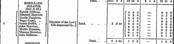
In Griffith’s Valuation the area in Roeillaun was a total of 3 acres, 0 rood & 32 perch of land. The total annual ratable valuation for the land was £1-2s-0d.
Occupiers: Patrick Gibbons, Edmund Mannion, Martin Naughton, Roger Conry, James Griffin, John Mannion, Martin Mannion, Thomas Mannion & John Halloran.
Immediate Lessor: Directors of the Law Life Assurance Co.
Poor Law Union Ireland
In Ireland the Poor Relief Act of 1838 divided into districts or “unions” in which the local taxable inhabitants were to be financially responsible for all paupers in the area. In 1898 the Poor Law Union was adopted as the basic administrative division in place of the civil parish and barony. Further subdivision into 828 registration districts and 3,751 district electoral divisions followed. Townlands were not arranged according to these divisions with parish and barony retained as a means to make comparisons with records gathered before 1898.
The 1838 Act
The main provisions of the 1838 Act were:
- The extension of the existing Poor Law Commissioners’ powers to Ireland, with the appointment of Assistant Commissioners who were to implement the Act in Ireland.
- The division of the country into Poor Law Unions based on Irish electoral divisions which where they made up from townlands.
- The creation of a Board of Guardians for each Union, two-thirds of whom were to be elected, the other third to be appointed ex officio.
- The setting up of a workhouse in each Union.
- The collection of a local poor-rate to finance the system.
- Assistance for emigration.
Initially, 130 Unions were created, based upon 2,049 electoral divisions. The divisions were composed of townlands, a peculiarly Irish unit, traditionally of 120 Irish acres in area. (Between 1848 and 1850, an additional 33 Unions were created by subdividing and reorganizing the boundaries of some existing Unions, particularly in the west of the country.
Boards of Guardians were elected annually on 25th March. Only rate-payers were eligible for election, which effectively disenfranchised most of the native Irish who were usually tenants at this time. Rate-payers were allowed between one and six votes depending on the size of a valuation of their property.
What is a townland?
A townland is one of the smallest land divisions in Ireland. They range in size from a few acres to thousands of acres. Many are Gaelic in origin, but some came into existence after the Norman invasion of 1169. Roeillaun is in Kilbreckan townland.
Population & Census Information
1841-1891 – No one lived on the Island, Valuation of the land in 1881 & 1891 was £1 2s 0d.
1901 Census – No one lived on the Island.
http://www.census.nationalarchives.ie/pages/1901/Galway/Turlough/
1911 Census – No one lived on the Island.
http://www.census.nationalarchives.ie/pages/1911/Galway/Turlough/
Maps
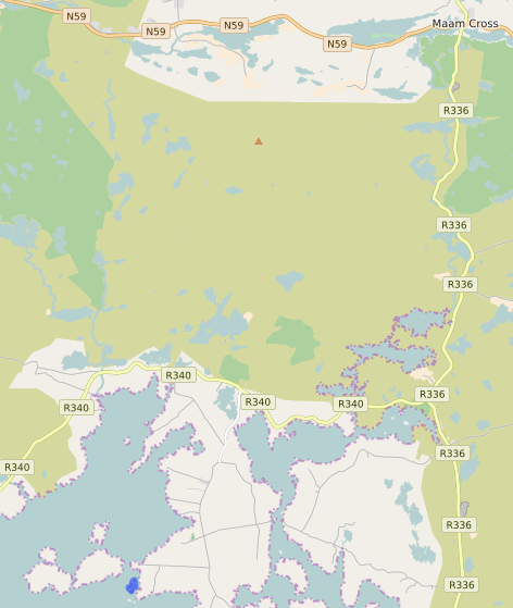
It is located at 53° 20′ 59″ N, 9° 38′ 45″ W.
Original OS maps at the Ordnance Survey of Ireland website.
Below is a link to the Ordnance Survey of Ireland website. It displays the original OS map that was created in the 1840s.
Information from the National Monuments Service.
You can use this link to view a map of archaeological features. This link brings you to a website wherein you will have to search for your townland.
Archaeological map from the National Monuments Service
Townlands.ie Website
https://www.townlands.ie/galway/moycullen/kilcummin/turlough/roeillaun/
Galway Library Website
http://places.galwaylibrary.ie/place/53240


No Comments
Add a comment about this page