Gortrevagh
Text Mary Kyne, Maps & Hyperlinks Antoinette Lydon


Gortrevagh is in the civil parish of Kilcummin. The civil parish corresponds with the following Church of Ireland parish of Kilcummim, Galway West. In general, the civil parish and the Church of Ireland parish are the same as is the case in the Kilcummin Oughterard area.
Gortrevagh is in the Electoral Division of Oughterard, in Civil Parish of Kilcummin, in the Barony of Moycullen, in the County of Galway
Irish Form of Name: Gort Riabhach.
Description:
The land is good, all under tillage except for 2 acres of bog.
Boundaries
Gortrevagh is situated in the Northern extremity of the parish of Kilcummin. It is bounded on the North by Portacarron, on the East by Annagh, Killaun, Knockkilliree, Moyvoon East, Moyvoon West, on the West by Rushveela and on the South by Magherabeg and Magheramore.
Other forms of name.
Gortrevagh
Gort Riabhach
Riabhach
Gurtreavagh in the Boundary Surveyor
Gortrevagh in the Barony Cess Book
Gortrevagh – Local
Gortrevagh in the County Map
Gortreagh – Inquis. Temp. Gul
Gortrevagh borders the following other townlands:
- Annaghkeelane to the east
- Knockkillaree to the east
- Magherabeg to the south
- Magheramore to the west
- Moyvoon East to the east
- Moyvoon West to the south
- Portacarron to the north
- Rushveala to the west
Area
The area contains 222 acres of land, about 60 acres of which is bog and a few patches of brushwood and rocks, the remainder is good arable land. There is a village called after the townland, situated in the Easterly part of the townland and an old fort near its Northern boundary. The road from Galway to Oughterard passes through it. The landlord was Arthur French, Tyrone.
Landlord
The landlord was Arthur French St George of Tyrone. Arthur French resided at Tyrone House. St. George (Tyrone House) – The St. George estate was centred on the house at Tyrone, parish of Drumacoo, barony of Dunkellin, built about 1779. This had originally been a French estate but the family assumed the title of St. George in 1774 due to inheritance from the St. George family of Hatley Manor, county Leitrim. In the 1830s A.F. St. George owned Tyrone House and Kilcolgan Castle, his agent was J. O’Hara. Wm. Griffith of Dublin also acted as an agent for the St. George estate. Arthur French St. George is described as a resident proprietor in 1824. In the early 19th century the St. Georges also owned large amounts of land in the baronies of Moycullen, Ballynahinch and Clare, which they advertised for sale in the early 1850s. Land in the barony of Clare had been acquired through Arthur French’s marriage with a Kirwan in the late 17th century. A portion of the St. George estate, situated in the barony of Longford, was offered for sale in the Encumbered Estates court in November 1853. In 1870s the family owned 15,777 acres in county Galway. By the early 1900s, however, some of the estate had been sold and the house at Tyrone had been left empty for long periods. In 1914 over 3000 acres of an estate described as St. George and Concannon was vested in the Congested Districts Board. Many members of the family are buried in a church-style mausoleum in the cemetery at Drumacoo.
Information from the Down Survey Website.
The Down Survey is a mapped survey. Using the Civil Survey as a guide, teams of surveyors, mainly former soldiers, were sent out under Petty’s direction to measure every townland to be forfeited to soldiers and adventurers. The resulting maps, made at a scale of 40 perches to one inch (the modern equivalent of 1: 50,000), were the first systematic mapping of a large area on such a scale attempted anywhere. The primary purpose of these maps was to record the boundaries of each townland and to calculate their areas with great precision. The maps are also rich in other detail showing churches, roads, rivers, castles, houses and fortifications. Most towns are represented pictorially and the cartouches, the decorative titles, of each map in many cases reflect a specific characteristic of each barony. (http://downsurvey.tcd.ie)
Townland of GORTREVAGH
Down Survey Name: Gortreagh 1641 Owner(s): Clanrickard, Earl of (Protestant) 1670 Owner(s): Clanrickard, Earl of (Protestant) County: Galway Barony: Muckullin Parish: Killcumyn Unprofitable land: 284 plantation acres Profitable land: 62 plantation acres Forfeited: 62 plantation acres
The down survey website will tell you who owned this townland in 1641 (pre Cromwell) and in 1671 (post Cromwell).
The Tithe Applotment Books
About the Records
Tithes were a tax on agricultural produce which was payable by the occupiers of agricultural land. They were the main source of income for the parish clergy of the Church of Ireland (the largest Protestant church and the church established by law). However, in many parishes a large part of the tithes was ‘appropriate’, which meant that they were payable to a bishop, cathedral chapter or another ecclesiastical recipient, or were ‘impropriate’, which generally meant that they were payable to a local landowner. The parishes used in the Tithe Applotment Books are civil or Church of Ireland parishes, which often differ in name and territory from Catholic parishes, Acts of Parliament of 1823 and 1832 provided for the conversion of tithes into a fixed charge on land, and specified the average price of wheat or oats in the parish in the seven years before 1821 as the basis on which the tithes would be calculated. They also extended the application of tithes to pasture, where previously they had been levied only on tillage.
This change in the law resulted in the valuation of individual holdings in almost all parishes containing agricultural land, in order to assess the portion of the tithes for which each occupier of land would be liable. The apportionment was recorded for each Church of Ireland parish in a Tithe Composition Applotment Book. The information was collected and the amounts were calculated by two Parochial Commissioners, one of whom was appointed by the cess-payers of the parish and the other by the relevant Diocese of the Church of Ireland. This procedure was carried out in over 2,500 parishes between the years 1823 and 1837.
The Tithe Applotment Books are in a variety of formats, from a few pages sewn together to elaborately bound volumes. In most cases they are written in manuscript throughout, although some consist of manuscript entries on printed questionnaires. The information in the books is broadly uniform and generally includes at least the name of occupier; the size of holding, the valuation and the tithe payable. In some cases, more detailed information is provided. Some volumes have maps and most have certificates and correspondence attached.
The sub-divisions of the parish were recorded. Some of these subdivisions, such as plough lands, ceased to be in official use after the six-inch survey of the Ordnance Survey was completed in the 1840s. Only productive land was subject to tithe, and the books usually distinguish between this tithable land and untithable land such as roads or mountains. Tithable land was in some cases classified by quality, and a money value was given to each class. In some cases, the proportion of tithe payable to the rector, vicar or lay proprietor of the tithes was set out. The column for observations was sometimes completed, with information about commonage, for example.
There are a number of other points that should be noted. The acreages given in the Tithe Applotment Books are in Irish or Plantation measure, which is 1.62 times larger than statute measure. Only occupiers of land at the time of the tithe composition are recorded, so not all heads of households living in a parish at the time are included. Only rural areas are systematically covered, although inhabitants of towns who held plots of cultivable land are included. The equivalent tax in urban areas, Minister’s Money, has left few records.
The Tithe Applotment Books are an important source of information for a wide variety of researchers of pre-Famine Ireland. They provide the first surviving national list of the occupiers of land, and are used by genealogists as a partial substitute for returns of the 1821 and 1831 censuses of population, which were destroyed in 1922. They also record information on the quality of land, and provide information on pre-Ordnance Survey territorial divisions, some of which were not recognized after the 1840s.
The National Archives hold the original Tithe Applotment Books only for the twenty-six counties of the Republic of Ireland. The books for the six counties of Northern Ireland are held in the Public Record Office of Northern Ireland in Belfast. (http://titheapplotmentbooks.nationalarchives.ie/search/tab/aboutmore.jsp)
Mich Barnett, Patt Conneely, John Conneely, John Gill, Patt Gill Dl Gill, Matt Gill, Patt Hallaran, John Hearan, John Hearan, Morgaran, Hearan, John Molloy, Michl Muggane, Patt O’Brian, Thos Rutlage & Richd Walsh had 56 acres of land; 21 acres of 1st quality land with a fee of 1s 6d, 10 acres of 2nd quality land with a fee of 1s per acre, 20 acres of 3rd quality with a fee of 6d per acre & 6 acres of 5th quality land with a fee of ⅛d per acre.
The Tithes were payable to Richard Martin Esq. Reverend James Daly & Reverend John Wilson.
Griffith’s Valuation 1850’s
In Griffith’s Valuation the area is 222 acres 8 perches.
Occupiers of the Land:
The occupiers of the land in Gortrevagh at this time were:
Edmund O’Flaherty, Martin Tierney, Patrick Tierney, Michael Barrett, Patrick O’Brien, Patrick Gill and William Furdon.
Ownership of Land and Property
Patrick O’Brien, Patrick Gill and William Furdon owned a house, offices and land. Edmund O’Flaherty, Martin Tierney, Patrick Tierney, Michael Barrett and Thomas Barrett owned a house and land. There were also 2 unoccupied houses.
Annual Valuation
The total annual valuation of rateable property in Gortrevagh came to £83 0s 0d.
Land Rates: Edmund O’Flaherty was rated at £40 10s, Patrick O’Brien and Patrick Gill were rated at £10, Michael Barrett and Thomas Barrett were rated at £2, William Furdon was rated at £12 10s, Patrick Tierney was rated at 13s and Martin Tierney was rated at 12s.
Building Rates: The buildings were rated at £5 10s. They were rated between 5s and £1 10s.
http://www.askaboutireland.ie/griffith-valuation/index.xml?action=doNameSearch&PlaceID=560057
View the heads of households in the townland at this time.
Out Offices and Land
The out office was a farm building, a cow house, piggery or barn. The land was very poor and sterile and people were always poverty-stricken. At this time most tenants were trying to eke out a living on 5acres or less and a farmer needed at least 15.3 acres to survive.
Clachan: The Irish is ‘Clochán’. A clachan was a small traditional settlement common in Ireland until the middle of the 20th century. They usually lacked a church, post office or other formal building. The origin is unknown but it is likely that they are of ancient root most likely dating to medieval times.
People living in Clachans had the support of a tight knit community.
In some cases, the clachans have evolved into holiday villages or one or two houses have been taken over turning smaller houses into agricultural outhouses.
Poor Law Union Ireland
In Ireland the Poor Relief Act of 1838 divided into districts or “unions” in which the local taxable inhabitants were to be financially responsible for all paupers in the area. In 1898 the Poor Law Union was adopted as the basic administrative division in place of the civil parish and barony. Further subdivision into 828 registration districts and 3,751 district electoral divisions followed. Townlands were not arranged according to these divisions with parish and barony retained as a means to make comparisons with records gathered before 1898.
The 1838 Act
The main provisions of the 1838 Act were:
- The extension of the existing Poor Law Commissioners’ powers to Ireland, with the appointment of Assistant Commissioners who were to implement the Act in Ireland.
- The division of the country into Poor Law Unions based on Irish electoral divisions which were themselves made up from townlands.
- The creation of a Board of Guardians for each Union, two-thirds of whom were to be elected, the other third to be appointed ex officio.
- The setting up of a workhouse in each Union.
- The collection of a local poor-rate to finance the system.
- Assistance for emigration.
Initially, 130 Unions were created, based upon 2,049 electoral divisions. The divisions were composed of townlands, a peculiarly Irish unit, traditionally of 120 Irish acres in area. (Between 1848 and 1850, an additional 33 Unions were created by subdividing and reorganizing the boundaries of some existing Unions, particularly in the west of the country.
Boards of Guardians were elected annually on 25th March. Only rate-payers were eligible for election, which effectively disenfranchised most of the native Irish who were usually tenants at this time. Rate-payers were allowed between one and six votes depending on the size of a valuation of their property.
Townlands
A town land is one of the smallest land divisions in Ireland. They range in size from a few acres to thousands of acres. Many are Gaelic in origin, but some came into existence after the Norman invasion 1169. Gortrevagh is a townland.
Population & Census Information
People who lived here:
You can retrieve a list of people who lived in this townland from 1827 to 1911. This list is compiled from the following resources.
- The Tithe Applotment Books
- Griffith’s Valuation
- 1901 Census
- 1911 Census
List of nineteenth century and early twentieth century inhabitants of this townland.
1841-1891 Census
1841 – 40 houses with 199 people
1851 – 10 houses with 58 people
1861 – 10 houses with 42 people
1871 – 11 houses with 56 people
1881 – 12 houses (10 inhabited) with 40 people (18 males, 22 females). There were 18 outbuildings.
The valuation of Houses & Land in 1881 was £85 10s 0d.
1891 – 11 houses (11 inhabited) with 34 people (15 males, 19 females). There were 18 outbuildings.
The valuation of Houses & Land in 1891 was £85 12s 0d.
1901 Census Gortrevagh
This is a return of the members of the family, their Visitors, Boarders, Servants who slept or abode in their house on the night of Sunday March 31st 1901 in Gortrevagh.
There were 10 houses listed in the Townland of Gortrevagh. The people were all Roman Catholics and they were born in County Galway.
Class of House: The class of house depended on the materials used in the roof, walls, number of rooms and number of front windows. A 1st class house was considered the highest standard.
Walls of the houses: The walls were of stone, brick, concrete or of mud, wood or other perishable material.
Roofs: Roofs were of slate, iron, tiles, thatch, wood or other perishable material. The roofs of houses were of thatch, wood or perishable material. Most likely they were thatched as there was ample reeds for thatching in the lakes.
House Occupancy: Each of the 9 inhabited houses was occupied by one family.
Enumerators Extract
http://www.census.nationalarchives.ie/reels/nai000840780/
House & Building Returns
http://www.census.nationalarchives.ie/reels/nai000840781/
Out Offices & Farm Steadings
None attached to the Census Website
The people listed as Head of the Family were also listed as the lawful Landholder of the property.
House 1: Robert E.Willis aged 32 was head of the family. He lived with his wife Annie 31, 3 daughters Mary 5, Alicia A. 3 and Bedelia aged 2. Also living in the house was Joseph Hardinan aged 36, a boarder and 3 servants Mary Conaly 49, Mary Walsh 18 and Bartholomew Finnerty aged 19. Robert was a farmer and Magistrate. Both himself and his wife could read and write. Joseph could also read and write but the 3 servants were unable to read or write. Only the servants spoke both English and Irish. Mary Conaly was employed as a Nurse Domestic servant, Mary Walsh was a General domestic servant and Bartholomew was a Farm Servant. They lived in a second class house with 2 windows. Eleven rooms occupied 9 persons.
http://www.census.nationalarchives.ie/pages/1901/Galway/Oughterard/Gortrevagh/1394679/
House 2: Honor Barrett a widow, aged 76 was head of the house. She lived with her widowed sister Anne O’Connor aged 70. They were both unable to read or write, Honor spoke only Irish and Anne spoke both English and Irish. Anne was listed as a housekeeper. They lived in a 3rd class house with 2 windows to the front. Three rooms occupied 2 persons.
http://www.census.nationalarchives.ie/pages/1901/Galway/Oughterard/Gortrevagh/1394680/
House 3: John Earnor aged 80 was head of the house. He was a widower living with his son Peter aged 24 and daughter Margaret aged 19. John could not read or write. John and his two children were shepherds. Peter and Margaret could read and write and they all spoke both Irish and English. They lived in a 3rd class house with 2 windows. Three rooms occupied 3 persons.
http://www.census.nationalarchives.ie/pages/1901/Galway/Oughterard/Gortrevagh/1394681/
House 4: Patrick Molloy aged 63 was head of the house. He lived with his wife Penelope aged 49. Also in the house the night of the census was his niece Mary Walsh aged 12. Mary was a scholar. They could all read and write and spoke Irish and English. Patrick was a shopkeeper. They lived on the premises, it was a second class house/shop with 4 front windows. Three rooms occupied 3 people.
http://www.census.nationalarchives.ie/pages/1901/Galway/Oughterard/Gortrevagh/1394682/
House 5: Ellen Hariss, a widow aged 75 was head of the house. She lived with her son Thomas aged 38, daughter in law Margaret aged 25, Granddaughter Mary Anne 5 and Grandsons Thomas M aged 4 and Patrick Joseph aged 1. Thomas could read and write, his moth and wife could not. They all spoke Irish and English. Thomas was a wool weaver. They lived in a 3rd class house with 2 windows. One room occupied all 6 people.
http://www.census.nationalarchives.ie/pages/1901/Galway/Oughterard/Gortrevagh/1394683/
House 6: Mary Sullivan aged 64 was head of the house. Mary was not married. She could not read or write and she spoke Irish and English. She was a house keeper. She lived alone in a 3rd class house with one window. One room occupied 1 person.
http://www.census.nationalarchives.ie/pages/1901/Galway/Oughterard/Gortrevagh/1394684/
House 7: Mary Lydon aged 60 was head of the house. She was unable to read or write. Also in the house the night of the census was her niece, Julia Clancy aged 11. Julia could read and write and they could both speak both Irish and English. Mary was a dressmaker and Julia was in school. They lived in a 3rd class house with one window. Two rooms occupied 2 persons.
http://www.census.nationalarchives.ie/pages/1901/Galway/Oughterard/Gortrevagh/1394685/
House 8: Uninhabited
House 9: Bridget Moloney, a widow aged 62 was head of the house. She lived with her son Thomas aged 40. Bridget was a housekeeper and Thomas was an agricultural labourer. They spoke Irish and could not read or write. They lived in a 3rd class house with one window. Two rooms occupied 2 people.
http://www.census.nationalarchives.ie/pages/1901/Galway/Oughterard/Gortrevagh/1394686/
House 10: Mary Walsh, a widow, aged 43 was head of the house. Mary could not read or write and spoke both Irish and English. She was a farmer. She lived in a 3rd class house with no windows. Two rooms occupied one person.
http://www.census.nationalarchives.ie/pages/1901/Galway/Oughterard/Gortrevagh/1394687/
Gortrevagh Census 1911
This is a return of the Members of families in Gortrevagh, their visitors, boarders and servants who slept or abode in the house on the night of Sunday the 2nd of April 1911.
Description of the Houses
All the houses in Gortrevagh were listed as private dwellings and were built of concrete or stone. The roofs of the houses were of wood, thatch or other perishable material. Most likely they were thatched. The heads of the families were listed as the landholders. One family lived in each property. The Class of the house depended on the material used in the roof, walls, number of rooms and number of front windows.
General Information
One family lived in each of the 8 houses listed. They were all Roman Catholics and the head of the family was the landholder. There were 11 males and 13 females a total of 24 persons living in the village.
Enumerators Extract
http://www.census.nationalarchives.ie/reels/nai002435621/
House & Building Returns
http://www.census.nationalarchives.ie/reels/nai002435623/
Out Offices & Farm Steadings
http://www.census.nationalarchives.ie/reels/nai002435625/
House 1: Bridget Moloney, a widow aged 80 was head of the house. She lived with her granddaughter Delia aged 14. Bridget could not read or write, Delia could read and write. They both spoke Irish. Bridget had 3 children born alive and 2 still living. She lived in a 3rd class house with no windows. Two rooms occupied 2 people. They also had 1 turf house.
http://www.census.nationalarchives.ie/pages/1911/Galway/Oughterard/Gortrevagh/471263/
House 2: Mary Walsh, a widow aged 70 lived alone. She could not read or write and spoke both Irish and English. She lived in a 3rd class house with one window. Two rooms occupied 1 person. She had no additional outside buildings.
http://www.census.nationalarchives.ie/pages/1911/Galway/Oughterard/Gortrevagh/471264/
House 3: Thomas Harris aged 51 was head of the house. He lived with his wife Margaret aged 36. He had one daughter Mary Anne 16 and 5 sons Thomas Michael `14, Patrick Joseph 12, John 9, James 5 and Stephen Francis aged 1. They could all read and write except the younger children. They spoke both Irish and English. Thomas was a wool weaver. Margaret had 6 children born alive and 6 children still living. They lived in a 2nd class house with 3 front windows. Three rooms occupied 8 people. They had no additional outside buildings.
http://www.census.nationalarchives.ie/pages/1911/Galway/Oughterard/Gortrevagh/471265/
House 4: Margaret Sullivan aged 75 was head of the house. She was single and was living alone. She could not read or write and could speak both Irish and English. She lived in a third class house with 1 front window. One room occupied 1 person. She had no additional buildings.
http://www.census.nationalarchives.ie/pages/1911/Galway/Oughterard/Gortrevagh/471266/
House 5: Penelope Molloy, a widow, aged 58 was head of the house. She lived with her niece Mary Walsh aged 21. Penelope is listed as a farmer but the house in which they lived was a shop. They could both read and write and spoke English and Irish. Penelope had no children. She lived in a 2nd class house/shop with 4 front windows. Three rooms occupied 2 people. They had a stable, cow house and piggery.
http://www.census.nationalarchives.ie/pages/1911/Galway/Oughterard/Gortrevagh/471267/
House 6: Thomas Molloney aged 53 was head of the house. He lived with his wife Margaret aged 53. They had no children. Thomas was a labourer. They could both read and write and spoke both Irish and English. They lived in a 2nd class house with 2 front windows. Four rooms occupied 2 people. They had 1 barn.
http://www.census.nationalarchives.ie/pages/1911/Galway/Oughterard/Gortrevagh/471268/
House 7: Peter Earner aged 30 was head of the house. He was a single agricultural labourer and shepherd. Peter could read and write and spoke both Irish and English. He lived in a 3rd class house with one window. Two rooms occupied 1 person. He had no additional outside buildings.
http://www.census.nationalarchives.ie/pages/1911/Galway/Oughterard/Gortrevagh/471269/
House 8: Robert E. Willis aged 42 was head of the house. He lived with his wife Annie aged 41 and his two daughters Lily 13 and Dilla aged 12. Annie had 3 children born alive and 2 still living. Robert is listed as a farmer. Also living in the house was a boarder Joseph Hardiman aged 46 and two servants, Thomas Conneely aged 30 and Mary Conneely aged 66. Thomas was a farm servant and Mary was a domestic servant. Both servants spoke both Irish and English, the rest of the household spoke just English. They could all read and write except for Mary Conneely. They lived in a 2nd class house with 6 front windows, six rooms occupied 7 people. In addition, they had a stable, coach house, harness room, cow house, piggery, fowl house, barn, potato house and a shed.
http://www.census.nationalarchives.ie/pages/1911/Galway/Oughterard/Gortrevagh/471270
Church records of births, deaths and marriages:
Church records of births, deaths and marriages are available online at http://www.rootsireland.ie. To search these records, you will need to know the ‘church parish’ rather than the ‘civil parish’. (The civil parish is the pre-reformation parish and was frequently used as a unit of administration in the past.)
Gortrevagh is in the civil parish of Kilcummin.
Roman Catholic parishes:
This civil parish corresponds with the following Roman Catholic parish or parishes.
- Carraroe
- Kilannin
- Kilcummin/Oughterard
- Rosmuc
Church of Ireland parishes:
This civil parish corresponds with the following Church of Ireland parish.
- Kilcummin
In general, the civil parish and the Church of Ireland parish are the same, but, this is not always the case.
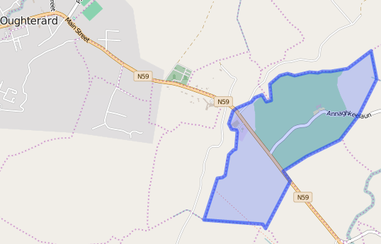
Maps
It is located at 53° 25′ 10″ N, 9° 17′ 28″ W.
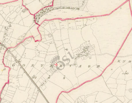
Original OS map of this area.
Ireland was first mapped in the 1840s. These original maps are available online.
Original OS maps at the Ordnance Survey of Ireland website.
Below is a link to the Ordnance Survey of Ireland website. It displays the original OS map that was created in the 1840s.
Information from Google Maps.
You can use this link to find this townland on Google Maps.
Information from the National Monuments Service.
You can use this link to view a map of archaeological features. This link brings you to a website wherein you will have to search for your townland.
Archaeological map from the National Monuments Service
Townlands.ie Website
https://www.townlands.ie/galway/moycullen/kilcummin/oughterard/gortrevagh/
Galway Library Website
http://places.galwaylibrary.ie/place/52469


No Comments
Add a comment about this page