Drumminnakill
Antoinette Lydon


Drumminnakill is in the civil parish of Kilcummin. The civil Parish corresponds with the following Church of Ireland parish of Kilcummin, Galway West. In general the civil parish and the Church of Ireland parish are the same as is the case in the Kilcummin Oughterard area.
Drumminnakill is in the Electoral Division of Oughterard, in Civil Parish of Kilcummin, in the Barony of Moycullen, in the County of Galway
Other Forms of the Name:
Dremnakilland
Drimmanakele
Drimmamakill
Drumnekille
Area:
Drumminnakill contained 59 acres, 2 roods, 14 perches
Boundaries:
Drumminnakill borders the following other townlands:
- Derreenmeel to the south
- Foorannagh to the east
- Gortdrisagh to the west
The following belong to the townland of Drimmankill:
Illaunwauranaran or Annagh Island
Landlords:
Martin (Ross) – The Martin family were established beside Ross Lake in the barony of Moycullen, county Galway, from the late 16th century, where they purchased land from the O’Flahertys. They were Royalist supporters and were dispossessed of their property in the city of Galway by the Cromwellians. Robert Martin received a grant of 2,909 acres in the barony of Moycullen, by patent dated 21 Aug 1677. Jasper Martin of Ross, who died in 1700, had two sons Jasper and Richard, from whom descend the two branches of the family settled at Ross and Ballynahinch. Nicholas Martin, who died in 1811, married Elizabeth O’Hara, daughter of Robert O’Hara of Lenaboy, and according to Burke’s ”Landed Gentry”, a grandniece of James O’Hara, 2nd Baron Tyrawley. Their grandson, James Martin of Ross, had sixteen children from his two marriages. His daughter, Maud, married H. Callwell and they were the parents of the author, J. M. Callwell. The youngest daughter of James Martin was Violet Florence Martin of the well known literary team Somerville and Ross. The Martins of Ross owned 5,767 acres in county Galway in the 1870s. They advertised the sale of their estate in the Landed Estates’ Court in May 1885.
Martin (Ballynahinch) – A branch of the Anglo Norman family of Martin, one of the Tribes of Galway, was granted the O’Flaherty lands in the Connemara region in the mid 17th century. This family were a junior branch of the Martins of Ross and under the Acts of Settlement were granted vast estates in counties Galway, Mayo, Roscommon, Clare and Sligo. By a patent dated 1698 they were confirmed in the possession of their Connemara estate known as the Manor of Claremount by King William. The Westport Estate Papers document the sale of over 27,000 acres in the baronies of Moycullen and Ballynahinch by the trustees for the sale of Colonel John Browne’s estate to John Edwards for Richard Martin in 1699. The early generations of Martins lived at Birch Hall and Dangan, in the townland of Oranhill, parish of Rahoon, near Galway city. Richard Martin, better known as ‘Humanity Dick’, was the first member of the family to be reared as a Protestant. He was a famous duellist and founded the Society for the Prevention of Cruelty to Animals. Ballynahinch Castle was built in the centre of his estate. His son Thomas Martin died in 1847 during the Famine and Thomas’s only daughter and heir, Mary Laetita, inherited a heavily encumbered estate. She married her cousin, Arthur Gonne Bell, and died in New York in 1850. The Martin estates were offered for sale in two sections in 1849. Their property close to Galway town included Dangan, Corcullen, Bushypark and Killeen. Their Connemara estate was acquired by the Law Life Assurance Society in 1852, to whom it was heavily mortgaged. In 1853 the estate of almost 200,000 acres was surveyed by Thomas Colville Scott for a prospective buyer. Richard Martin, second son of Richard ‘Humanity Dick’ Martin of Ballynahinch, is recorded as holding five townlands in the parish of Killannin, barony of Moycullen, county Galway, at the time of Griffith’s Valuation although he emigrated to Canada in 1833. He was also recorded as the occupier of Clareville, a Martin home in the village of Oughterard. Many of his descendants still reside in Canada.
Downs Survey:
Townland of DRUMMINNAKILL
Down Survey Name: Drumnekille
1641 Owner(s): Blake, Francis (Catholic)
1670 Owner(s): Matthews, Francis (Protestant)
County: Galway
Barony: Muckullin
Parish: Killcumyn
Unprofitable land: 20 plantation acres
Profitable land: 44 plantation acres
Forfeited: 44 plantation acres
http://downsurvey.tcd.ie/landowners.php#mc=53.456167,-9.341821&z=14
The Tithe Applotment Books
About the Records
Tithes were a tax on agricultural produce which was payable by the occupiers of agricultural land. They were the main source of income for the parish clergy of the Church of Ireland (the largest Protestant church and the church established by law). However, in many parishes a large part of the tithes were ‘appropriate’, which meant that they were payable to a bishop, cathedral chapter or other ecclesiastical recipient, or were ‘impropriate’, which generally meant that they were payable to a local landowner. The parishes used in the Tithe Applotment Books are civil or Church of Ireland parishes, which often differ in name and territory from Catholic parishes, Acts of Parliament of 1823 and 1832 provided for the conversion of tithes into a fixed charge on land, and specified the average price of wheat or oats in the parish in the seven years before 1821 as the basis on which the tithes would be calculated. They also extended the application of tithes to pasture, where previously they had been levied only on tillage.
This change in the law resulted in the valuation of individual holdings in almost all parishes containing agricultural land, in order to assess the portion of the tithes for which each occupier of land would be liable. The apportionment was recorded for each Church of Ireland parish in a Tithe Composition Applotment Book. The information was collected and the amounts were calculated by two Parochial Commissioners, one of whom was appointed by the cess-payers of the parish and the other by the relevant Diocese of the Church of Ireland. This procedure was carried out in over 2,500 parishes between the years 1823 and 1837.
The Tithe Applotment Books are in a variety of formats, from a few pages sewn together to elaborately bound volumes. In most cases they are written in manuscript throughout, although some consist of manuscript entries on printed questionnaires. The information in the books is broadly uniform and generally includes at least the name of occupier; the size of holding, the valuation and the tithe payable. In some cases more detailed information is provided. Some volumes have maps and most have certificates and correspondence attached.
The sub-divisions of the parish were recorded. Some of these subdivisions, such as ploughlands, ceased to be in official use after the six inch survey of the Ordnance Survey was completed in the 1840s. Only productive land was subject to tithe, and the books usually distinguish between this tithable land and untithable land such as roads or mountains. Tithable land was in some cases classified by quality, and a money value was given to each class. In some cases the proportion of tithe payable to the rector, vicar or lay proprietor of the tithes was set out. The column for observations was sometimes completed, with information about commonage, for example.
There are a number of other points that should be noted. The acreages given in the Tithe Applotment Books are in Irish or Plantation measure, which is 1.62 times larger than statute measure. Only occupiers of land at the time of the tithe composition are recorded, so not all heads of households living in a parish at the time are included. Only rural areas are systematically covered, although inhabitants of towns who held plots of cultivable land are included. The equivalent tax in urban areas, Minister’s Money, has left few records.
The Tithe Applotment Books are an important source of information for a wide variety of researchers of pre-Famine Ireland. They provide the first surviving national list of the occupiers of land, and are used by genealogists as a partial substitute for returns of the 1821 and 1831 censuses of population, which were destroyed in 1922. They also record information on the quality of land, and provide information on pre-Ordnance Survey territorial divisions, some of which were not recognised after the 1840s.
The National Archives hold the original Tithe Applotment Books only for the twenty-six counties of the Republic of Ireland. The books for the six counties of Northern Ireland are held in the Public Record Office of Northern Ireland in Belfast. (http://titheapplotmentbooks.nationalarchives.ie/search/tab/aboutmore.jsp)
Tithe Applotment Books – Drumminnakill
Michael Meons had 35 acres; 9 acres 2nd quality with a payment of 1s, 8 acres 3rd quality with a payment of 3d, & 18 acres of 5th quality land with a payment of ⅛d.
The Tithes payments went to Richard Martin Esq. James Daly & the Reverend John Wilson.
http://titheapplotmentbooks.nationalarchives.ie/reels/tab//004587459/004587459_00435.pdf
Griffiths’s Valuation
In Griffith’s valuation the area was 50 acres, 0 rood & 19 perch with a land value £9 10s 0d. Value of Buildings was £2 0s & 0d. Total valuation of £11 10s 0d.
Walter Mons was the Occupier and the Immediate Lessor was The Directors of the Law Life Assurance Co.
Poor Law Union Ireland
In Ireland the Poor Relief Act of 1838 divided into districts or “unions” in which the local taxable inhabitants were to be financially responsible for all paupers in the area. In 1898 the Poor Law Union was adopted as the basic administrative division in place of the civil parish and barony. Further subdivision into 828 registration districts and 3,751 district electoral divisions followed. Townlands were not arranged according to these divisions with parish and barony retained as a means to make comparisons with records gathered before 1898.
The 1838 Act
The main provisions of the 1838 Act were:
- The extension of the existing Poor Law Commissioners’ powers to Ireland, with the appointment of Assistant Commissioners who were to implement the Act in Ireland.
- The division of the country into Poor Law Unions based on Irish electoral divisions which were they made up from townlands.
- The creation of a Board of Guardians for each Union, two-thirds of whom were to be elected, the other third to be appointed ex officio.
- The setting up of a workhouse in each Union.
- The collection of a local poor-rate to finance the system.
- Assistance for emigration.
Initially, 130 Unions were created, based upon 2,049 electoral divisions. The divisions were composed of townlands, a peculiarly Irish unit, traditionally of 120 Irish acres in area. (Between 1848 and 1850, an additional 33 Unions were created by subdividing and reorganizing the boundaries of some existing Unions, particularly in the west of the country.
Boards of Guardians were elected annually on 25th March. Only rate-payers were eligible for election, which effectively disenfranchised most of the native Irish who were usually tenants at this time. Rate-payers were allowed between one and six votes depending on the size of a valuation of their property.
Out Offices and Land
The out office was a farm building, a cow house, piggery or barn. The land was very poor and sterile and people were always poverty-stricken. At this time most tenants were trying to eke out a living on 5 acres or less and a farmer needed at least 15.3 acres to survive.
Townlands
A town land is one of the smallest land divisions in Ireland. They range in size from a few acres to thousands of acres. Many are Gaelic in origin, but some came into existence after the Norman invasion 1169. Drumminnakill is a townland.
Genealogy / Ancestry / Records Search
- Search the 1911 Irish Census for Drumminnakill
- Search the 1901 Irish Census for Drumminnakill
- Search Griffith’s Valuation (1847-1864) for Drumminnakill
Census 1841-1891
1841 – 1 house with 10 people
1851 – 1 house with 10 people
1861 – 2 houses with 10 people
1871 – 2 houses with 8 people
1881 – 2 house (2 inhabited) with 10 people (3 males / 7 females). There were 2 outbuildings. Total Valuation of Houses & Lands £10 0s 0d.
1891 – 2 houses (2 inhabited) with 8 people (3 males / 5 females). There were 2 Outbuildings. Total Valuation of Houses & Lands £10 10s 0d.
Census 1901 Drumminnakill
This is a return of the member of the family, their Visitors, Boarders, and Servants who slept or abode in their house on the night of 31st of March 1901 in Drumminnakill. There were 2 houses listed in the townland of Drumminnakill (one was unoccupied). 8 (4 females/ 4 males) were all Roman Catholics. There were a total of 3 farm buildings and out offices which included a calf house, cow house & a piggery.
The people that lived in Drumminnakill were born in Galway City & Co. Galway.
Enumerator Extract
http://www.census.nationalarchives.ie/reels/nai000840725/
House & Building Return
http://www.census.nationalarchives.ie/reels/nai000840726/
Out Offices & Farm Steadings
http://www.census.nationalarchives.ie/reels/nai000840727/
House 1
Robert I Mons aged 47 was head of the family; married to Bridget aged 40, they lived with their children Patrick I aged 15, Christina M aged 13, Michael I aged 12, Mary K aged 8, Robert W aged 6 and Catherine Rabbit aged 76.
Robert was a Police pensioner and a farmer, Patrick, Christina, Michael & Mary were scholars. Catherine was a domestic servant. Robert, Bridget, Patrick, Christina, Michael and Mary could read and write. Robert W and Catherine could not read. Robert I, Bridget, Patrick, Christina, Michael & Catherine spoke Irish & English. Robert W was listed as Dumb only.
They lived in a 2nd class house with 3 rooms and 4 front windows. They had a cow house, a calf house and a piggery.
http://www.census.nationalarchives.ie/pages/1901/Galway/Oughterard/Drumminnakill/1394645/
House 2
Uninhabited
Census 1911 – Drumminnakill
This is a return of the Members of the families in Drumminnakill, their visitors, boarders and servants who slept or abode in the house on the night of Sunday 2nd April 1911.
There was 1 house listed in the Townland of Drumminnakill. Of the people living in Drumminnakill all 5 (3 males/2 females) were Roman Catholics.
People that lived in Drumminnakill were born included Co. Galway. There were a total of 5 farm buildings and out offices which included a calf house, cow house, barn, fowl house & a piggery.
Enumerator Extract
http://www.census.nationalarchives.ie/reels/nai002435505/
House & Building Return
http://www.census.nationalarchives.ie/reels/nai002435507/
Out Offices & Farm Steadings
http://www.census.nationalarchives.ie/reels/nai002435509/
House 1
Bridget Mons aged 48 was head of the family; a widow; she lived with her children Patrick I aged 24, Michael J aged 21, Mary K aged 19 and Robert W aged 15.
Patrick and Michael were farmer’s sons & Mary was a scholar. Bridget, Patrick, Michael and Mary could read and write; they spoke Irish & English. Robert could not read.
Bridget was married for 21 years; she had 6 children with 5 still living at the time of the census.
They lived in a 2nd class house with 2 rooms and 3 front windows. They had a cow house, a calf house, a fowl house, a barn and a piggery.
http://www.census.nationalarchives.ie/pages/1911/Galway/Oughterard/Drumminnakill/471229/
Church records of births, deaths and marriages:
Church records of births, deaths and marriages are available online at http://www.rootsireland.ie. To search these records you will need to know the ‘church parish’ rather than the ‘civil parish’. (The civil parish is the pre-reformation parish and was frequently used as a unit of administration in the past.)
Drumminnakill is in the civil parish of Kilcummin.
Catholic parish:
This civil parish corresponds with the following Roman Catholic parish or parishes.
- Clonbern & Kilkerrin in Galway East.
- Carraroe in Galway West.
- Kilannin in Galway West.
- Kilcummin/Oughterard in Galway West.
- Rosmuc in Galway West.
Church of Ireland parish:
This civil parish corresponds with the following Church of Ireland parish.
- Kilcummin in Galway West.
In general, the civil parish and the Church of Ireland parish are the same, but, this is not always the case.
Map:
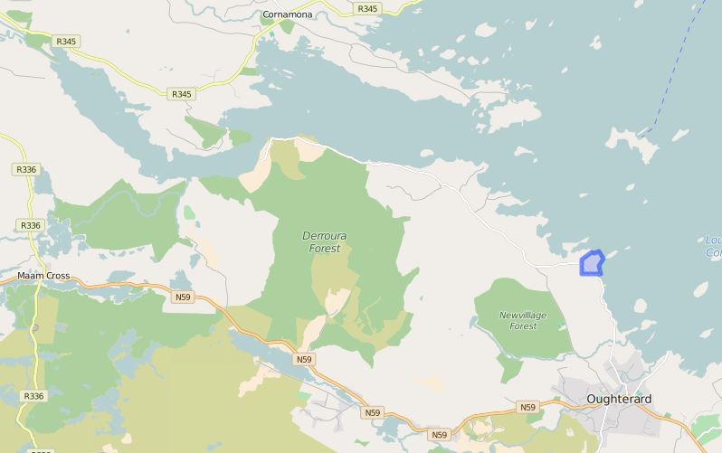
http://www.townlands.ie/galway/moycullen/kilcummin/oughterard-ed/drumminnakill/
Google Maps
Taken from A Valley Remembers GLANN (local publication)
DRUMINAKILL Droim Na Coille,
The wooded ridge Area 50 acres
This small townland, as the name implies, is a wooded ridge or hillock that juts into the lake on the most eastern part of the Glann area. It commands panoramic views over the lake towards Inchagoill and Cong and east to Galway. It is the first townland considered to be part of the Glann area as one drives along the lake road from Oughterard. It is bordered on the north by Newvillage and to the west by Gortdrisagh It is mostly wooded with some fine dry land on the ridge or drumlin area while the lower parts are boggy. Foorannagh (Fuar Annach—Cold peninsula) at its most northerly part is a long narrow peninsula (3½ acres) protruding into the lake. In 1641 the townland was the property of Francis Blake.? At the time of Griffiths Valuation;the lessor of the land was the Directors of the Law Life Assurance Co. of London so it was part of the Martin Estate. Walter Mons lived and farmed there. The rent was £9.10.0 on the land and £2.0.0 on the house. At the time of the 1911 census there was only one family resident here, the Mons family. Bridget Mons with 5 resident in the house. Drimnakill has been in the Mons family since the 1850s. Walter Mons was the tenant farmer of it in 1850. He farmed the 50 acres of Drimnakill as well as the headland of Fooranagh, then an island ,and the island of Roeillaun. The land had been part of the vast Connemara estate of the Martins but after they were bankrupted by their creditors it passed to the Law Life Assurance Company of London. His daughter Margaret was born in 1848 and son Robert in 1854. Drimnakill stayed in Robert’s family until it was inherited by Margaret’s grandson John Taylor in 1980. Robert married Bridget O Sullivan in 1885 they had six children Patrick, Christina (Tiff), Michael John, Mary Kate, Bridget who died very young and Robert. Robert is one of the residents in 1911 census but died in his teens. At the time of the 1911 census Bridget was renting 90 acres Drimnakill, Roeilaun, Annagh Island and Illaunanarrour from H.W. Hodgson of Currarevagh. At this time Christina had left to nurse in England. In the 1930s Bridget received the free hold of Drimnakill. Patrick became a Peace Commisioner in 1936. Bridget died in 1938. Michael John worked in the local dole office in Oughterard. Patrick, Michael John, Mary Kate and Christina who returned from England all continued to farm Drimnakill. None of them ever married. In the mid 1950s they sold a site of land to a Dr Galligan from Dublin who built a holiday home there, sold it to Roches and it is still owned by the same family for a holiday home.
Margaret Mons, Robert’s older sister, married Michael Houlihan of Oughterard. their daughter, Bedelia, (also known as Dell—this lady is grandmother of present owners Nicky and Fran Taylor) was born in the house now occupied by Finnerty’s Butcher. Margaret died at age of 42 in 1890 and her husband Michael and daughter Dell moved to London where Dell married Patrick Taylor from Leitrim in 1916. Their son John grew up in England and spent most of World War 2 as a prisioner in Poland where he contracted T.B. After he got married in 1950, he moved back to Dublin on doctors’ orders and often visited his Drimnakill cousins. Pat Mons died in 1962, Michael John in 1974, Christina in 1979, and Mary Kate in 1980. She left Drimnakill to John Taylor. He sold most of the farm land to Petie Tierney, but for 17 years John and Jean Taylor would come and live in Drimnakill for six months every year at the house and lake shore they loved. In 1998, the year after John died, ownership passed through his wife to his daughters Fran and Nicky. They come and visit whenever they can, Nicky with her husband Tim and daughter Kate and Fran with her partner Roger.
There are ten members of the family buried in Kilcummin cemetery—Margaret (120 years ago), along with seven of the Mons family, John and Jean Taylor, all together in the family plot. At the house, in spite of the changes, the Mons’s glass and delf are still on the dresser and their oil lamp is still on the side board and when the Taylor family are in Drimnakill they still eat at their kitchen table. At the time of the 1911 census there was 1 house with 5 resident today there are 5 houses and 7 residents on a permanent basis
- TAYLORS AS HOLIDAY HOME
- ROCHES AS HOLIDAY HOME
- MICHAEL PATRICIA AND JOHN McGAULEY WITH 3 RESIDENT
- JOSEPH ANN MARIE CILLIAN AND SAOIRSE TIERNEY WITH 4 RESIDENT
- MARK McGAULEY


No Comments
Add a comment about this page