Derreighter
Antoinette Lydon


Derreighter is in the civil parish of Kilcummin. The civil Parish corresponds with the following Church of Ireland parish of Kilcummin, Galway West. In general, the civil parish and the Church of Ireland parish are the same as is the case in the Kilcummin Oughterard area.
Derreighter is in the Electoral Division of Oughterard, in Civil Parish of Kilcummin, in the Barony of Moycullen, in the County of Galway
Irish Form of Name: Doire Íochtair
Translation: lower derry or oak wood
Parish: Kilcummin View all place names in this civil parish.
Other Forms of the Name with the authority source (if provided) in italics.
Derreighter
Doire Iochtair
Derreeghter Boundary Surveyor
Derryeighter Barony Cess Book
Derreeghter Local
Derryeighter Barony Map
Derreighter Inquis. Temp. Jac.
Description:
A mountainous and wet land, very stony. Contains 847¼ acres of land about 20 acres of which are under tillage and 30 acres of water, the remainder is mountain pasture.
Situation:
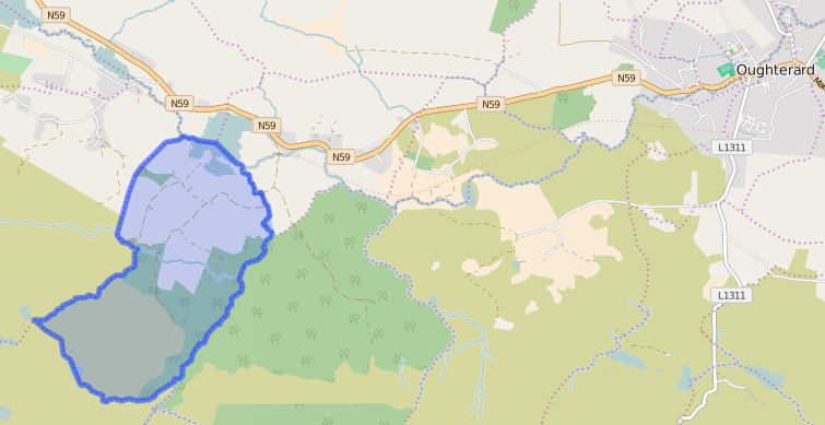
In the northern extremity of the parish, bounded on the North by Derryglin, West by Leam East, East by Lettercroff and Derradda and South by Cloghermore and Derradda.
This is a list of townlands that share a border with this townland.
Proprietor; Nolan of Ballinderry
Information on the owner’s family from the Landed Estates Database
Nolan (Ballinderry) – The Nolans were Elizabethan settlers in the Ballinrobe area of county Mayo. They lost most of their estate in county Mayo to the Cuffs during the Commonwealth and were transplanted to Ballinderry in the parish of Cummer, barony of Clare, county Galway. A notebook in the National Library contains a copy of a patent dated 20 Aug 1677 which refers to the Nolan interest in lands in the baronies of Kilmaine, Clanmorris and Gallen, county Mayo and in the baronies of Clare, Dunmore and Ballymoe, county Galway. At the time of Griffith’s Valuation their estate at Ballinderry was mainly in the parish of Cummer but also included townlands in the parishes of Annaghdown and Belclare and the Nolans still had 2 townlands in the parish of Kilcommon and 2 townlands in the parish of Kilmainebeg, barony of Kilmaine, county Mayo. A volume in the Kirwan of Dalgin collection traces the early generations as Patrick Nolan who married Anne Browne in 1667, John married Ellis Brabazon in 1709, Patrick married a Martin of Tulira. Through a late 18th century marriage with Margaret the daughter and heiress of James French of Portacarron, parish and barony of Moycullen, county Galway, an estate in that district came into the possession of John Nolan, son of Patrick. In 1809 their son John Nolan married Mary Browne daughter of John Browne of Castlemoyle. Mary Anne Nolan, widow of John Nolan of Ballinderry and herself a Nolan of Lugboy, county Mayo, held townlands and islands in the parishes of Moyrus, Kilcummin and Killannin in the barony of Moycullen at the time of Griffith’s Valuation. She and her husband had 6 sons of whom John Philip Nolan was a Member of Parliament for county Galway for much of the later part of the 19th century. Burke’s ”Landed Gentry of Ireland” records that J.P. Nolan’s younger brother Walter Raymond Nolan was heir to his maternal grandfather. Sebastian Nolan, a very wealthy bachelor, lived at Castlemoyle and later at Seamount, Salthill. Philip John Nolan was the only one of the brothers to marry. In the 1870s the estate amounted to 6,866 acres with an additional 800 acres in county Mayo. Walter M. Nolan of the Army and Navy Club, London owned 1852 acres in county Galway in the 1870s. The records of the land agents Denis J. Kirwan and Sons contain late 19th century records relating to the estate of Colonel W.R. Nolan in the parishes of Kilquain and Killimorbologue, barony of Longford, Annaghdown and Belclare, barony of Clare, Monieva, barony of Tiaquin and Dunmore, barony of Ballymoe.
Information from the Down Survey Website:
The Down Survey is a mapped survey. Using the Civil Survey as a guide, teams of surveyors, mainly former soldiers, were sent out under Petty’s direction to measure every townland to be forfeited to soldiers and adventurers. The resulting maps, made at a scale of 40 perches to one inch (the modern equivalent of 1:50,000), were the first systematic mapping of a large area on such a scale attempted anywhere. The primary purpose of these maps was to record the boundaries of each townland and to calculate their areas with great precision. The maps are also rich in other detail showing churches, roads, rivers, castles, houses and fortifications. Most towns are represented pictorially and the cartouches, the decorative titles, of each map in many cases reflect a specific characteristic of each barony. (http://downsurvey.tcd.ie)
The Down Survey website will tell you who owned this townland in 1641 (pre Cromwell) and in 1671 (post Cromwell).
Townland of DERREIGHTER
Down Survey Name: Drumandare
1641 Owner(s): O’Flaharty, Murragh (Catholic)
1670 Owner(s): Matthews, Francis (Protestant)
County: Galway
Barony: Muckullin
Parish: Killcumyn
Unprofitable land: 22 plantation acres
Profitable land: 77 plantation acres
Forfeited: 77 plantation acres
The Tithe Applotment Books
About the Records
Tithes were a tax on agricultural produce which was payable by the occupiers of agricultural land. They were the main source of income for the parish clergy of the Church of Ireland (the largest Protestant church and the church established by law). However, in many parishes a large part of the tithes were ‘appropriate’, which meant that they were payable to a bishop, cathedral chapter or other ecclesiastical recipient, or were ‘impropriate’, which generally meant that they were payable to a local landowner. The parishes used in the Tithe Applotment Books are civil or Church of Ireland parishes, which often differ in name and territory from Catholic parishes, Acts of Parliament of 1823 and 1832 provided for the conversion of tithes into a fixed charge on land, and specified the average price of wheat or oats in the parish in the seven years before 1821 as the basis on which the tithes would be calculated. They also extended the application of tithes to pasture, where previously they had been levied only on tillage.
This change in the law resulted in the valuation of individual holdings in almost all parishes containing agricultural land, in order to assess the portion of the tithes for which each occupier of land would be liable. The apportionment was recorded for each Church of Ireland parish in a Tithe Composition Applotment Book. The information was collected and two Parochial Commissioners calculated the amounts, one of who was appointed by the cess-payers of the parish and the other by the relevant Diocese of the Church of Ireland. This procedure was carried out in over 2,500 parishes between the years 1823 and 1837.
The Tithe Applotment Books are in a variety of formats, from a few pages sewn together to elaborately bound volumes. In most cases they are written in manuscript throughout, although some consist of manuscript entries on printed questionnaires. The information in the books is broadly uniform and generally includes at least the name of occupier, the size of holding, the valuation and the tithe payable. In some cases, more detailed information is provided. Some volumes have maps and most have certificates and correspondence attached.
The sub-divisions of the parish were recorded. Some of these subdivisions, such as ploughlands, ceased to be in official use after the six-inch survey of the Ordnance Survey was completed in the 1840s. Only productive land was subject to tithe, and the books usually distinguish between this tithable land and untithable land such as roads or mountains. Tithable land was in some cases classified by quality, and a money value was given to each class. In some cases, the proportion of tithe payable to the rector, vicar or lay proprietor of the tithes was set out. The column for observations was sometimes completed, with information about commonage, for example.
There are a number of other points that should be noted. The acreages given in the Tithe Applotment Books are in Irish or Plantation measure, which is 1.62 times larger than statute measure. Only occupiers of land at the time of the tithe composition are recorded, so not all heads of households living in a parish at the time are included. Only rural areas are systematically covered, although inhabitants of towns who held plots of cultivable land are included. The equivalent tax in urban areas, Minister’s Money, has left few records.
The Tithe Applotment Books are an important source of information for a wide variety of researchers of pre-Famine Ireland. They provide the first surviving national list of the occupiers of land, and are used by genealogists as a partial substitute for returns of the 1821 and 1831 censuses of population, which were destroyed in 1922. They also record information on the quality of land, and provide information on pre-Ordnance Survey territorial divisions, some of which were not recognized after the 1840s.
The National Archives hold the original Tithe Applotment Books only for the twenty-six counties of the Republic of Ireland. The books for the six counties of Northern Ireland are held in the Public Record Office of Northern Ireland in Belfast. http://titheapplotmentbooks.nationalarchives.ie/search/tab/aboutmore.jsp
Bartley Costello, Edmd Costello, James Flaherty, Tom Flaherty, Peter Kenedy, Tim Kenedy, Pat McDonagh, James Scanlon, John Scanlon & James Tollan were listed as having land in Derryeighter & Derryoughter. They had 10 acres of 4th quality land with a payment of ½d.
The Tithes payments went to Richard Martin Esq. James Daly & the Reverend John Wilson.
http://titheapplotmentbooks.nationalarchives.ie/reels/tab//004587459/004587459_00446.pdf
Griffiths Valuation
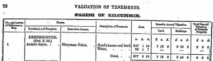
In Griffith’s valuation the area was 847 acres, 1 rood & 12 perch with a land value £7 10s 0d. 30 acres 1 rood & 7 perch of water. There was herd’s house in the townland. Value of Buildings was £0 10s & 0d. Total Rateable Valuation was £8 0s 0d.
Occupier of Land – Andrew Joyce.
Immediate Lessor – Maryanne Nolan
http://www.askaboutireland.ie/griffith-valuation/index.xml?action=doNameSearch&PlaceID=559883
View the heads of households in the townland at this time
Out Offices and Land
The out office was a farm building, a cow house, piggery or barn. The land was very poor and sterile and people were always poverty-stricken. At this time most tenants were trying to eke out a living on 5 acres or less and a farmer needed at least 15.3 acres to survive.
Poor Law Union Ireland
In Ireland the Poor Relief Act of 1838 divided into districts or “unions” in which the local taxable inhabitants were to be financially responsible for all paupers in the area. In 1898 the Poor Law Union was adopted as the basic administrative division in place of the civil parish and barony. Further subdivision into 828 registration districts and 3,751 district electoral divisions followed. Townlands were not arranged according to these divisions with parish and barony retained as a means to make comparisons with records gathered before 1898.
The 1838 Act
The main provisions of the 1838 Act were:
- The extension of the existing Poor Law Commissioners’ powers to Ireland, with the appointment of Assistant Commissioners who were to implement the Act in Ireland.
- The division of the country into Poor Law Unions based on Irish electoral divisions which were they made up from townlands.
- The creation of a Board of Guardians for each Union, two-thirds of whom were to be elected, the other third to be appointed ex officio.
- The setting up of a workhouse in each Union.
- The collection of a local poor-rate to finance the system.
- Assistance for emigration.
Initially, 130 Unions were created, based upon 2,049 electoral divisions. The divisions were composed of townlands, a peculiarly Irish unit, traditionally of 120 Irish acres in area. (Between 1848 and 1850, an additional 33 Unions were created by subdividing and reorganizing the boundaries of some existing Unions, particularly in the west of the country.
Boards of Guardians were elected annually on 25th March. Only rate-payers were eligible for election, which effectively disenfranchised most of the native Irish who were usually tenants at this time. Rate-payers were allowed between one and six votes depending on the size of a valuation of their property.
Townland Information
A townland is one of the smallest land divisions in Ireland. They range in size from a few acres to thousands of acres. Many are Gaelic in origin, but some came into existence after the Norman invasion of 1169. Derreighter is a townland.
Other placenames in this townland:
Some other placenames in or near this townland are …
- Knockwaumnamoe (trigonometrical station)
- Loughagraffard (lake)
Population & Census Information
People who lived here:
You can retrieve a list of people who lived in this townland from 1827 to 1911. This list is compiled from the following resources.
- The Tithe Applotment Books
- Griffith’s Valuation
- 1901 Census
- 1911 Census
List of nineteenth century and early twentieth century inhabitants.
Census 1841-1891
1841 – 3 houses with 12 people
1851 – 1 house with 4 people
1861 – 1 house with 5 people
1871 – 1 house with 4 people
1881 – 1 house (1 inhabited) with 6 people (4 males / 2 females). There were no outbuildings. Total Valuation of Houses & Lands £8 0s 0d.
1891 – 1 house (1 inhabited) with 7 people (4 males / 3 females). There were 2 Outbuildings. Total Valuation of Houses & Lands £8 0s 0d.
1901 Census
This is a return of the member of the family, their Visitors, Boarders, and Servants who slept or abode in their house on the night of 31st of March 1901 in Derreighter. There was 1 house listed in the townland of Derreighter. 5 (2 females/ 3 males) were all Roman Catholics. The people that lived in Derreighter were born in Co. Galway.
Enumerators Extract
http://www.census.nationalarchives.ie/reels/nai000840711/
House & Building Returns
http://www.census.nationalarchives.ie/reels/nai000840712/
Out Offices & Farm Steadings
http://www.census.nationalarchives.ie/reels/nai000840713/
House 1
John McDonagh aged 54 was head of the household; married to Julia aged 55. They lived with their children Dermot aged 15, James aged 13 & Bridget aged 12.
John was a farmer, Dermot was a farmer’s son and James & Bridget were scholars. John & Julia could not read; Dermot, James & Bridget could read & write. The entire family spoke Irish & English.
They lived in a 3rd class house with 2 rooms and no front window. They had a cow house. The was a private dwelling.
http://www.census.nationalarchives.ie/pages/1901/Galway/Oughterard/Derreighter/1394642/
Census 1911 – Derreighter
This is a return of the Members of the families in Derreighter, their visitors, boarders and servants who slept or abode in the house on the night of Sunday 2nd April 1911.
There was 1 house (1 inhabited) listed in the Townland of Derreighter. Of the people living in Derreighter all 6 (4 males/2 females) were Roman Catholics.
People that lived in Derreighter were born included Co. Galway. There were a total of 4 farm buildings and out offices which included cow houses, barn, & a piggery.
Enumerators Extract
http://www.census.nationalarchives.ie/reels/nai002435465/
House & Building Returns
http://www.census.nationalarchives.ie/reels/nai002435467/
Out Offices & Farm Steadings
http://www.census.nationalarchives.ie/reels/nai002435469/
House 1
John McDonagh aged 66 was head of the household; married to Julia aged 69. They lived with their children Patrick aged 33, Darby aged 31, James aged 29 & Bridget aged 27, single.
John was a farmer, Patrick, Darby & James were farmer’s sons and Bridget was a farmer’s daughter. John & Julia could not read; Patrick, Darby, James & Bridget could read & write. The entire family spoke Irish & English.
John & Julia were married for 36 years; they had 5 children with all 5 still living at the time of the census.
They lived in a 3rd class house with 2 rooms and 2 front windows. They had 2 cow houses, a piggery & a barn. This was a private dwelling.
http://www.census.nationalarchives.ie/pages/1911/Galway/Oughterard/Derreighter/912315/
Church records of births, deaths and marriages:
Church records of births, deaths and marriages are available online at http://www.rootsireland.ie. To search these records, you will need to know the ‘church parish’ rather than the ‘civil parish’. (The civil parish is the pre-reformation parish and was frequently used as a unit of administration in the past.)
Derreighter is in the civil parish of Kilcummin.
Catholic parish:
This civil parish corresponds with the following Roman Catholic parish or parishes.
- Clonbern & Kilkerrin in Galway East.
- Carraroe in Galway West.
- Kilannin in Galway West.
- Kilcummin/Oughterard in Galway West.
- Rosmuc in Galway West.
Church of Ireland parish:
This civil parish corresponds with the following Church of Ireland parish.
- Kilcummin in Galway West.
In general, the civil parish and the Church of Ireland parish are the same, but, this is not always the case.
Maps
It is located at 53° 24′ 32″ N, 9° 25′ 5″ W.
Original OS map of this area
Ireland was first mapped in the 1840s. These original maps are available online.
Original OS maps at the Ordnance Survey of Ireland website
Below is a link to the Ordnance Survey of Ireland website. It displays the original OS map that was created in the 1840s.
Information from Google Maps:
You can use this link to find this townland on Google Maps.
Information from the National Monuments Service:
You can use this link to view a map of archaeological features. This link brings you to a website wherein you will have to search for your townland.
Archaeological map from the National Monuments Service
Galway Library Website
http://places.galwaylibrary.ie/asp/fullresult.asp?id=52260
Townlands.ie Website
https://www.townlands.ie/galway/moycullen/kilcummin/oughterard/derreighter/


No Comments
Add a comment about this page