Derrada
Mary Kyne & Antoinette Lydon


Derradda is in the civil parish of Kilcummin. The civil Parish corresponds with the following Church of Ireland parish of Kilcummin, Galway West. In general the civil parish and the Church of Ireland parish are the same as is the case in the Kilcummin Oughterard area.
Derradda is in the Electoral Division of Oughterard, in Civil Parish of Kilcummin, in the Barony of Moycullen, in the County of Galway
Other forms of name.
The standard name is Derradda
Irish Form of Name: Doire Fhada – Translation: long derry or oak wood
Area: Contains 1,486½ acres of land about 50 acres of which are under tillage and 19½ acres of water, the remainder is mountain pasture. Land is very bad and mountainous.
Situation:
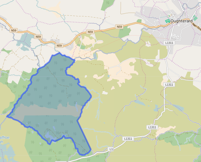
In the North Eastern part of the parish, bounded on the West by Shannadollaghan and Derreeghter on the North by Glengoula West, on the East by Rusheeny and on the South by Littercraffroo and Killannin Parish.
Derradda borders the following other townlands:
- Derreighter to the west
- Glengowla East to the north
- Glengowla West to the north
- Leitir Creamha Rua to the south
- Rusheeny to the east
- Seanadh Dolacháin to the west
Seecon to the east
Proprietor Arthur Ffrench, Esq., Tyrone. Later bought by Rev Chas Whitaker.
Landlords
- George (Tyrone House)– The St.George estate was centred on the house at Tyrone, parish of Drumacoo, barony of Dunkellin, built about 1779. This had originally been a French estate but the family assumed the title of St. George in 1774 due to inheritence from the St.George family of Hatley Manor, county Leitrim. In the 1830s A.F. St. George owned Tyrone House and Kilcolgan Castle, his agent was J. O’Hara. Wm. Griffith of Dublin also acted as an agent for the St. George estate. Arthur French St. George is described as a resident proprietor in 1824. In the early 19th century the St. Georges also owned large amounts of land in the baronies of Moycullen, Ballynahinch and Clare, which they advertised for sale in the early 1850s. Land in the barony of Clare had been acquired through Arthur French’s marriage with a Kirwan in the late 17th century. A portion of the St. George estate, situated in the barony of Longford, was offered for sale in the Encumbered Estates court in November 1853. In 1870s the family owned 15,777 acres in county Galway. By the early 1900s, however, some of the estate had been sold and the house at Tyrone had been left empty for long periods. In 1914 over 3000 acres of an estate described as St. George and Concannon was vested in the Congested Districts Board. Many members of the family are buried in a church-style mausoleoum in the cemetery at Drumacoo.
Rev. Chas Whitaker
- Whitaker– The Reverend Charles Whitaker bought an estate of over 5000 acres in the parish of Kilcummin, barony of Moycullen, county Galway, from the sale of the St. George Moycullen estate in 1852-1853 and the O’Flahertie estate in 1854 (Cloghermore). He still owned the estate valued at £36 and amounting to over 4000 acres in the 1870s. His address was given as North Wales.
Information from the Down Survey Website:
The Down Survey website will tell you who owned this townland in 1641 (pre Cromwell) and in 1671 (post Cromwell).
The Down Survey is a mapped survey. Using the Civil Survey as a guide, teams of surveyors, mainly former soldiers, were sent out under Petty’s direction to measure every townland to be forfeited to soldiers and adventurers. The resulting maps, made at a scale of 40 perches to one inch (the modern equivalent of 1:50,000), were the first systematic mapping of a large area on such a scale attempted anywhere. The primary purpose of these maps was to record the boundaries of each townland and to calculate their areas with great precision. The maps are also rich in other detail showing churches, roads, rivers, castles, houses and fortifications. Most towns are represented pictorially and the cartouches, the decorative titles, of each map in many cases reflect a specific characteristic of each barony. (http://downsurvey.tcd.ie)
The Down Survey website will tell you who owned this townland in 1641 (pre Cromwell) and in 1671 (post Cromwell).
The Tithe Applotment Books
About the Records
Tithes were a tax on agricultural produce which was payable by the occupiers of agricultural land. They were the main source of income for the parish clergy of the Church of Ireland (the largest Protestant church and the church established by law). However, in many parishes a large part of the tithes were ‘appropriate’, which meant that they were payable to a bishop, cathedral chapter or other ecclesiastical recipient, or were ‘impropriate’, which generally meant that they were payable to a local landowner. The parishes used in the Tithe Applotment Books are civil or Church of Ireland parishes, which often differ in name and territory from Catholic parishes, Acts of Parliament of 1823 and 1832 provided for the conversion of tithes into a fixed charge on land, and specified the average price of wheat or oats in the parish in the seven years before 1821 as the basis on which the tithes would be calculated. They also extended the application of tithes to pasture, where previously they had been levied only on tillage.
This change in the law resulted in the valuation of individual holdings in almost all parishes containing agricultural land, in order to assess the portion of the tithes for which each occupier of land would be liable. The apportionment was recorded for each Church of Ireland parish in a Tithe Composition Applotment Book. The information was collected and the amounts were calculated by two Parochial Commissioners, one of whom was appointed by the cess-payers of the parish and the other by the relevant Diocese of the Church of Ireland. This procedure was carried out in over 2,500 parishes between the years 1823 and 1837.
The Tithe Applotment Books are in a variety of formats, from a few pages sewn together to elaborately bound volumes. In most cases they are written in manuscript throughout, although some consist of manuscript entries on printed questionnaires. The information in the books is broadly uniform and generally includes at least the name of occupier; the size of holding, the valuation and the tithe payable. In some cases more detailed information is provided. Some volumes have maps and most have certificates and correspondence attached.
The sub-divisions of the parish were recorded. Some of these subdivisions, such as ploughlands, ceased to be in official use after the six-inch survey of the Ordnance Survey was completed in the 1840s. Only productive land was subject to tithe, and the books usually distinguish between this tithable land and untithable land such as roads or mountains. Tithable land was in some cases classified by quality, and a money value was given to each class. In some cases the proportion of tithe payable to the rector, vicar or lay proprietor of the tithes was set out. The column for observations was sometimes completed, with information about commonage, for example.
There are a number of other points that should be noted. The acreages given in the Tithe Applotment Books are in Irish or Plantation measure, which is 1.62 times larger than statute measure. Only occupiers of land at the time of the tithe composition are recorded, so not all heads of households living in a parish at the time are included. Only rural areas are systematically covered, although inhabitants of towns who held plots of cultivable land are included. The equivalent tax in urban areas, Minister’s Money, has left few records.
The Tithe Applotment Books are an important source of information for a wide variety of researchers of pre-Famine Ireland. They provide the first surviving national list of the occupiers of land, and are used by genealogists as a partial substitute for returns of the 1821 and 1831 censuses of population, which were destroyed in 1922. They also record information on the quality of land, and provide information on pre-Ordnance Survey territorial divisions, some of which were not recognised after the 1840s.
The National Archives hold the original Tithe Applotment Books only for the twenty-six counties of the Republic of Ireland. The books for the six counties of Northern Ireland are held in the Public Record Office of Northern Ireland in Belfast. (http://titheapplotmentbooks.nationalarchives.ie/search/tab/aboutmore.jsp)
Tithe Applotment of 1829
No entry found for Derradda
Griffiths Valuation 1850’s
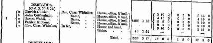
In Griffith’s Valuation the area is 1486 acres 1rood 33 perches with a land value of £16 0s 0d . Value of Buildings is £1 5s 0d, and the total value is £17 5s 0d. There was 10acres 2 roods 24perches under water. Total acreage: 1506 acres 0rood 17 perches.
Occupiers of the Land
Patrick O Brien, John Cottingham, James Walsh, Patrick Gibbons and Rev. Chas Whitaker
Landlord was Rev. Chas Whitaker.
Ownership of Land and Property
P. O Brien, J. Cottingham, J Walsh and P. Gibbons owned a house, out office (farm buildings) and land while Rev. C. Whitaker owned a house and land.
Annual Valuation
The total annual valuation of rateable property in Derrada came to £17 5s Patrick O Brien and Rev. Chas. Whitaker were rated at £3 15s 0d each for land and buildings while James Walsh and Patrick Gibbons were rated at £2 10s 0d and John Cottingham was rated £4 15s 0d
http://www.askaboutireland.ie/griffith-valuation/index.xml?action=doNameSearch&PlaceID=559864
Out Offices and Land
The out office was a farm building, a cow house, piggery or barn. The land was very poor and sterile and people were always poverty-stricken. At this time most tenants were trying to eke out a living on 5acres or less and a farmers needed at least 15.3 acres to survive.
Clachan: The Irish is ‘Clochán’. The houses in Derrada formed a Clachan. A clachan was a small traditional settlement common in Ireland until the middle of the 20th century. They usually lacked a church, post office or other formal building. The origin is unknown but it is likely that they are of ancient root most likely dating to medieval times.
The Derrada clachan was a cluster of small single storey farmers’ cottages built on poor land. They were related to the rundale system of farming. According to David Lloyd, The Great Famine 1845–1849 caused such disruption to the social system that the clachans virtually disappeared.
People living in Clachans had the support of a tight knit community.
In some cases the clachans have evolved into holiday villages or one or two houses have been taken over turning smaller houses into agricultural outhouses.
The Deserted Village of Derrada
“Carraig an Chailín”
In Glengowla West, Oughterard, there is a rock known locally as “Carraig an Chailín”. The people of the area would pass this rock daily on their way to Derrada, Glengowla, Oughterard to check on their stock. The dipping tank was built in an old wall by the late Josie Geoghegan and a second old wall where the remains of an old house can be seen held the sheep awaiting dipping, with a large yard to let them dry out in before letting them out into the hills. Connemara ponies and cattle were also kept there.
Ruins of the Village
Several ruins of a village were found in Derrada. The village was built under a small sheltering bluff on the hillside and lay amongst a nice grassy area, some of which had been cultivated for potato crops.
Twenty years ago these ruins were still free from the smothering mass of trees, and one could visualise what living conditions were like on this mountainside 200-300 years ago. The sturdy lichen covered natural stone gables of the roofless houses were in themselves beautiful to behold, but the layout of the village was fascinating.
From the remaining ruins, comprising of some 4-5 buildings only, it appeared that the houses were clustered close together rather in the style of the close knit community of the ancient Claddagh Village of Galway city. The single stone-walls of a connecting pathway between two of the houses still stood intact, covered with grayish white lichen. The largest building, and the only one with a proper chimneystack, was easily identified as the Shebeen. This house was built by the late John Geoghegan with the help of Henry O Toole (Tom Hannraoi), Leam and the chimney was built by the late Colman Walsh Leam who was considered a master of the trade. According to Hannah Geoghegan, daughter of John Geoghegan this was not a Shebeen and “ There was no trafficking of Poteen in the house or anywhere near it. The only Shebeen was in Glengowla West and was known far and wide as “ Tarrabildy’s.
According to Hannah there was a pathway from Derrada gardens north through lands of Glengowla West on to the Railway bridge known locally as the “ Lander’s” bridge across the river from there to the main Galway – to Clifden road opposite the late Paddy and Mary Conneely’s house. The moats erected on either side of that right-a-way are still to be seen.
The area on which the village was built was not large and was surrounded by bog. Some stunted mountain ash their branches blown into contorted shapes by the prevailing winds lent an eerie air to the area.
Potato Crop Failure
The story of this particular village is the familiar one of the potato crop failure forcing the entire community to emigrate and this they did en-masse on a September day 1847. Whether this story of that sad day stands up to scrutiny is of no great importance – what is important is the village they left behind, an actual visible example of how small communities built their homes and which endured the ferocity of the elements through the years until it was planted by the Forestry Department in the early 70’s. The plantation in itself was not offensive, in fact it lends a variety to what was rather a bleak mountainside, but unfortunately in the planting the possible aesthetic value of the ruins appear to have been over looked and the saplings were planted in and out amongst the ruins. These are now grown into mature trees and have effectively obliterated the little village. The total area of Derrada arable and mountain grazing is 1486 acres 2 roods 30 perches – Statue measure.
Local folklore maintains that the waters of the local village well had a cure for warts. You were expected to throw money into the well ( that is if you had money) and visit it three times before you were guaranteed a cure!
To retain the village intact would have been an expensive – the cost of a few dozen or so trees, but it would have been of inestimable value to have that little gem of our past still visible.
Note
Compiled by Mary Kyne from articles written by the late Olive Walsh and Hannah Geoghegan, Glengowla in 1993 in the “Oughterard Newsletter.”
Poor Law Union Ireland
In Ireland the Poor Relief Act of 1838 divided into districts or “unions” in which the local taxable inhabitants were to be financially responsible for all paupers in the area. In 1898 the Poor Law Union was adopted as the basic administrative division in place of the civil parish and barony. Further subdivision into 828 registration districts and 3,751 district electoral divisions followed. Townlands were not arranged according to these divisions with parish and barony retained as a means to make comparisons with records gathered before 1898.
The 1838 Act
The main provisions of the 1838 Act were:
- The extension of the existing Poor Law Commissioners’ powers to Ireland, with the appointment of Assistant Commissioners who were to implement the Act in Ireland.
- The division of the country into Poor Law Unions based on Irish electoral divisions which were themselves made up from townlands.
- The creation of a Board of Guardians for each Union, two-thirds of whom were to be elected, the other third to be appointed ex officio.
- The setting up of a workhouse in each Union.
- The collection of a local poor-rate to finance the system.
- Assistance for emigration.
Initially, 130 Unions were created, based upon 2,049 electoral divisions. The divisions were composed of townlands, a peculiarly Irish unit, traditionally of 120 Irish acres in area. (Between 1848 and 1850, an additional 33 Unions were created by subdividing and reorganizing the boundaries of some existing Unions, particularly in the west of the country.
Boards of Guardians were elected annually on 25th March. Only rate-payers were eligible for election, which effectively disenfranchised most of the native Irish who were usually tenants at this time. Rate-payers were allowed between one and six votes depending on the size of a valuation of their property.
Townlands
A town land is one of the smallest land divisions in Ireland. They range in size from a few acres to thousands of acres. Many are Gaelic in origin, but some came into existence after the Norman invasion 1169.
Other placenames in this townland:
Some other placenames in or near this townland are …
- Derradda (trigonometrical station) Locally known as Cruck Derradda or Derradda Hill –a high Hill
- Loughnagilky (lake): Irish form: Loch na Giolcaighe – lake of the reeds. Locally know as Loughayoulka – a small lough on the boundary of Derradda and Lettercraffroe.
- Scalpcallyagayne (house): Irish form Scailp Chaillighe i gCéin – cleft of the stranger hag. Known locally as Scalpnamnagayne – or the strange nomad’s cliff.
Folklore: It is said to be the residence of a woman who was a stranger in this country and who lost her friends and left her home to perish in this cliff.
Population & Census Information
You can retrieve a list of people who lived in this townland from 1827 to 1911. This list is compiled from the following resources.
- The Tithe Applotment Books
- Griffith’s Valuation
- 1901 Census
- 1911 Census
List of nineteenth century and early twentieth century inhabitants.
Census 1841-1911
1841 – 8 houses with 37 people
1851 – 7 houses with 41 people
1861 – 1 houses with 7 people
1871 – 1 houses with 5 people
1881 – 2 houses (2 inhabited) with 6 people (3 males / 3 females). There were no outbuildings. Total Valuation of Houses & Lands £16 10s 0d.
1891 – 1 house (1 inhabited) with 8 people (5 males / 3 females). There were no Outbuildings. Total Valuation of Houses & Lands £16 10s 0d.
1901 Census Derrada
This is a return of the members of the family, their Visitors, Boarders and Servants who slept or abode in their house on the night of Sunday March 31st 1901 in Derradda
There was only one house listed in the Townland of Derradda as opposed to 5 listed under Griffith’s Valuation. The people were all Roman Catholics and they were born in County Galway. There were 2 cow houses listed for the family.
Class of House: The class of house depended on the materials used in the roof, walls, number of rooms and number of front windows. A 1st class house was considered the highest standard.
Walls of the houses: The walls were of stone, brick, concrete or of mud, wood or other perishable material. The house in Derradda was a private dwelling and was built of stone, brick or concrete. It wasn’t a mud cabin.
Roofs: Roofs were of slate, iron, tiles, thatch, wood or other perishable material. The roof of the house was of thatch, wood or perishable material. Most likely it was thatched as there was ample reeds for thatching in the lakes.
House Occupancy: The house was occupied by one family.
Catherine Thornton was listed as Head of the Family and was also listed as the lawful Landholder of the property.
Enumerators Extract
http://www.census.nationalarchives.ie/reels/nai000840693/
House & Building Return
http://www.census.nationalarchives.ie/reels/nai000840694/
Out Offices & Farm Steadings
http://www.census.nationalarchives.ie/reels/nai000840695/
House 1: Catherine Thornton aged 80 a widow was listed as head of the family. She lived with her son Thomas 60 and his wife Catherine 60. Living with them were their children, Martin 22, Kate 17 and Edward 13. Catherine and her son Thomas were herds and daughter-in-law Catherine was a spinner. They didn’t read or write while the children Martin, Kate and Edward could read and write. The family spoke Irish and English. They lived in a Class 4 with no front window. They had 2 cow houses. 6 persons occupied one room. The occupation of the children was listed as sons and daughter of the herd.
http://www.census.nationalarchives.ie/pages/1901/Galway/Oughterard/Derradda/1394631/
Derradda Census 1911
There were no residents in Derradda at this time
Church records of births, deaths and marriages:
Church records of births, deaths and marriages are available online at http://www.rootsireland.ie. To search these records you will need to know the ‘church parish’ rather than the ‘civil parish’. (The civil parish is the pre-reformation parish and was frequently used as a unit of administration in the past.)
Derradda is in the civil parish of Kilcummin.
Catholic parish:
This civil parish corresponds with the following Roman Catholic parish or parishes.
- Clonbern & Kilkerrin in Galway East.
- Carraroe in Galway West.
- Kilannin in Galway West.
- Kilcummin/Oughterard in Galway West.
- Rosmuc in Galway West.
Church of Ireland parish:
This civil parish corresponds with the following Church of Ireland parish.
- Kilcummin in Galway West.
In general, the civil parish and the Church of Ireland parish are the same, but, this is not always the case.
Maps
It is located at 53° 24′ 1″ N, 9° 23′ 36″ W.
Original OS map of this area
Ireland was first mapped in the 1840s. These original maps are available online.
Original OS maps at the Ordnance Survey of Ireland website
Below is a link to the Ordnance Survey of Ireland website. It displays the original OS map that was created in the 1840s.
Information from Google Maps:
You can use this link to find this townland on Google Maps.
Information from the National Monuments Service:
You can use this link to view a map of archaeological features. This link brings you to a website wherein you will have to search for your townland.
Archaeological map from the National Monuments Service
Townlands.ie Website
http://www.townlands.ie/galway/moycullen/kilcummin/oughterard/derradda/
Galway Library Website
http://places.galwaylibrary.ie/asp/fullresult.asp?id=52230


No Comments
Add a comment about this page