Curraghduff Middle
Text - Mary Kyne, Hyperlinks - Antoinette Lydon


Curraghduff Middle is in the civil parish of Kilcummin. The civil Parish corresponds with the following Church of Ireland parish of Kilcummin, Galway West. In general, the civil parish and the Church of Ireland parish are the same as is the case in the Kilcummin Oughterard area.
Curraghduff Middle is in the Electoral Division of Letterfore, in Civil Parish of Kilcummin, in the Barony of Moycullen, in the County of Galway
Information from O’Donovan’s Field Name Books
The Irish name for Curraghduff Middle is An Currach Dubh Láir
Parish: Kilcummin
View all place names in this civil parish.
Other Forms of the Name with the authority source (if provided) in italics.
Curraghdhu Middle
Curraghdhu Middle Boundary Surveyor
Curraghduffe Barony Cess Book
Curraghduff Middle Local
Curraghduff T. H. O’Flaherty, Esq., Proprietor
This is a list of townlands that share a border with this townland.
Landlord: Captain O’Flaherty, Proprietor.
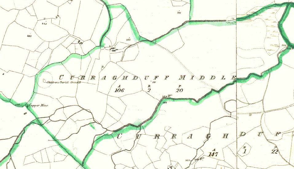
The land in Curraghduff Middle is very bad, stony and mountainous. It contains 106¼ acres, about 50 acres under tillage and pasture. The remainder is bog and rough pasture. There is a copper mine situated in its S. Western extremity also a Children’s Burial Ground (close to its Western boundary) and an old fort.
Additional Information from ‘A Valley Remembers Glann’ 2013
This townland lies West of Curraghduff East. It is a long narrow piece of land west of Owen na Raha river running to the old mines rail track on the hill. It is mostly mountainous land.
Information from the Down Survey Website:
The Down Survey is a mapped survey. Using the Civil Survey as a guide, teams of surveyors, mainly former soldiers, were sent out under Petty’s direction to measure every townland to be forfeited to soldiers and adventurers. The resulting maps, made at a scale of 40 perches to one inch (the modern equivalent of 1:50,000), were the first systematic mapping of a large area on such a scale attempted anywhere. The primary purpose of these maps was to record the boundaries of each townland and to calculate their areas with great precision. The maps are also rich in other detail showing churches, roads, rivers, castles, houses and fortifications. Most towns are represented pictorially and the cartouches, the decorative titles, of each map in many cases reflect a specific characteristic of each barony. (http://downsurvey.tcd.ie)
The Down Survey website will tell you who owned this townland in 1641 (pre Cromwell) and in 1671 (post Cromwell).
Townland of CURRAGHDUFF MIDDLE
Down Survey Name: Curragduffe
1641 Owner(s): Clanrickard, Earl of (Protestant)
1670 Owner(s): Clanrickard, Earl of (Protestant)
County: Galway
Barony: Muckullin
Parish: Killcumyn
Unprofitable land: 15 plantation acres
Profitable land: 46 plantation acres
Forfeited: 46 plantation acres
In 1641 it was a part of Bryan O fflahertie’s estate. Captain T.H O fflahertie was the proprietor at the time of the Griffith’s Valuation.
The Tithe Applotment Books
About the Records
Tithes were a tax on agricultural produce which was payable by the occupiers of agricultural land. They were the main source of income for the parish clergy of the Church of Ireland (the largest Protestant church and the church established by law). However, in many parishes a large part of the tithes were ‘appropriate’, which meant that they were payable to a bishop, cathedral chapter or other ecclesiastical recipient, or were ‘impropriate’, which generally meant that they were payable to a local landowner. The parishes used in the Tithe Applotment Books are civil or Church of Ireland parishes, which often differ in name and territory from Catholic parishes, Acts of Parliament of 1823 and 1832 provided for the conversion of tithes into a fixed charge on land, and specified the average price of wheat or oats in the parish in the seven years before 1821 as the basis on which the tithes would be calculated. They also extended the application of tithes to pasture, where previously they had been levied only on tillage.
This change in the law resulted in the valuation of individual holdings in almost all parishes containing agricultural land, in order to assess the portion of the tithes for which each occupier of land would be liable. The apportionment was recorded for each Church of Ireland parish in a Tithe Composition Applotment Book. The information was collected and two Parochial Commissioners calculated the amounts, one of who was appointed by the cess-payers of the parish and the other by the relevant Diocese of the Church of Ireland. This procedure was carried out in over 2,500 parishes between the years 1823 and 1837.
The Tithe Applotment Books are in a variety of formats, from a few pages sewn together to elaborately bound volumes. In most cases they are written in manuscript throughout, although some consist of manuscript entries on printed questionnaires. The information in the books is broadly uniform and generally includes at least the name of occupier, the size of holding, the valuation and the tithe payable. In some cases more detailed information is provided. Some volumes have maps and most have certificates and correspondence attached.
The sub-divisions of the parish were recorded. Some of these subdivisions, such as ploughlands, ceased to be in official use after the six-inch survey of the Ordnance Survey was completed in the 1840s. Only productive land was subject to tithe, and the books usually distinguish between this tithable land and untithable land such as roads or mountains. Tithable land was in some cases classified by quality, and a money value was given to each class. In some cases, the proportion of tithe payable to the rector, vicar or lay proprietor of the tithes was set out. The column for observations was sometimes completed, with information about commonage, for example.
There are a number of other points that should be noted. The acreages given in the Tithe Applotment Books are in Irish or Plantation measure, which is 1.62 times larger than statute measure. Only occupiers of land at the time of the tithe composition are recorded, so not all heads of households living in a parish at the time are included. Only rural areas are systematically covered, although inhabitants of towns who held plots of cultivable land are included. The equivalent tax in urban areas, Minister’s Money, has left few records.
The Tithe Applotment Books are an important source of information for a wide variety of researchers of pre-Famine Ireland. They provide the first surviving national list of the occupiers of land, and are used by genealogists as a partial substitute for returns of the 1821 and 1831 censuses of population, which were destroyed in 1922. They also record information on the quality of land, and provide information on pre-Ordnance Survey territorial divisions, some of which were not recognised after the 1840s.
The National Archives hold the original Tithe Applotment Books only for the twenty-six counties of the Republic of Ireland. The books for the six counties of Northern Ireland are held in the Public Record Office of Northern Ireland in Belfast. (http://titheapplotmentbooks.nationalarchives.ie/search/tab/aboutmore.jsp)
No information listed for Curraghduff Middle
Griffiths Valuation 1850’s
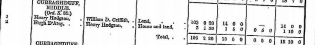
In Griffith’s Valuation the area is 106 acres 2 roods 20 perches with a land value of £15 5s 0d. Value of building is 5s 0d, and the total value is £15 10s.
Occupiers of the Land:
Henry Hodgson – Immediate Lessor William Griffith
Hugh D’Arcy – Immediate Lessor Henry Hodgson
Landlord was Henry Hodgson
Ownership of Land and Property
Henry Hodgson – 103 acres 30 perches and no building on the land.
Hugh D’Arcy owned land and a house – 3 acres 1 rood 30 perches.
Annual Valuation
Henry Hodgson land valuation was £14.
Hugh D’Arcy was rated at £1 5s for the land and 5s for a building.
Poor Law Union Ireland
In Ireland the Poor Relief Act of 1838 divided into districts or “unions” in which the local taxable inhabitants were to be financially responsible for all paupers in the area. In 1898 the Poor Law Union was adopted as the basic administrative division in place of the civil parish and barony. Further subdivision into 828 registration districts and 3,751 district electoral divisions followed. Townlands were not arranged according to these divisions with parish and barony retained as a means to make comparisons with records gathered before 1898.
The 1838 Act
The main provisions of the 1838 Act were:
- The extension of the existing Poor Law Commissioners’ powers to Ireland, with the appointment of Assistant Commissioners who were to implement the Act in Ireland.
- The division of the country into Poor Law Unions based on Irish electoral divisions which were themselves made up from townlands.
- The creation of a Board of Guardians for each Union, two-thirds of whom were to be elected, the other third to be appointed ex officio.
- The setting up of a workhouse in each Union.
- The collection of a local poor-rate to finance the system.
- Assistance for emigration.
Initially, 130 Unions were created, based upon 2,049 electoral divisions. The divisions were composed of townlands, a peculiarly Irish unit, traditionally of 120 Irish acres in area. (Between 1848 and 1850, an additional 33 Unions were created by subdividing and reorganizing the boundaries of some existing Unions, particularly in the west of the country.
Boards of Guardians were elected annually on 25th March. Only rate-payers were eligible for election, which effectively disenfranchised most of the native Irish who were usually tenants at this time. Rate-payers were allowed between one and six votes depending on the size of a valuation of their property.
Out Offices and Land
The out office was a farm building, a cow house, piggery or barn. The land was very poor and sterile and people were always poverty-stricken. At this time most tenants were trying to eke out a living on 5 acres or less and a farmers needed at least 15.3 acres to survive.
Townlands
A town land is one of the smallest land divisions in Ireland. They range in size from a few acres to thousands of acres. Many are Gaelic in origin, but some came into existence after the Norman invasion 1169. Curraghduff Middle is a townland.
1841-1891 Census (House & People living in Curraghduff Middle)
1841 – 6 houses with 31 people
1851 – 1 house with 8 people
1861 – 5 houses with 22 people
1871 – 2 houses with 12 people
1881 – 2 houses with 7 people (4 males & 3 females). Both houses were occupied. There was 1 outbuilding. Valuation of the house & land was £15 10s 0d.
1891 – 3 houses with 15 people (6 males & 9 females). All 3 houses were occupied. There was 3 outbuilding. Valuation of the house & land was £15 16s 0d.
1901 Census Curraghduff Middle
This is a return of the members of the family, visitors, boarders or servants who slept or abode in their house on the night of Sunday March 31st 1901 in Curraghduff Middle.
There were 3 houses listed in the Townland of Curraghduff Middle. The people were all Roman Catholics and they were born in County Galway. There were 8 males and 10 females in the townland and they all lived in private dwellings. There were 5 in total of farm buildings and out offices which included, 3 cow houses, 1 piggery and a fowl house.
Enumerators Extract
http://www.census.nationalarchives.ie/reels/nai000840312/
House & Building Return
http://www.census.nationalarchives.ie/reels/nai000840313/
Out Offices & Farm Steadings
http://www.census.nationalarchives.ie/reels/nai000840314/
Class of House: The class of house depended on the materials used in the roof, walls, number of rooms and number of front windows. A 1st class house was considered the highest standard.
Walls of the houses: The walls were of stone, brick, concrete or of mud, wood or other perishable material. The houses in Curraghduff Middle were built of stone, brick or concrete. There were no mud cabins.
Landholder of the property unless otherwise stated was the lawful owner.
Roofs were of slate, iron, tiles, thatch, wood or other perishable material. The roofs of houses were of thatch, wood or perishable material. Most likely they were thatched as there was ample reeds for thatching in the lakes.
House Occupancy: Each of the 3 houses was occupied by one family.
The people listed as Head of the Family were also listed as the lawful Landholder of the property.
House 1: Patrick Lydon a farmer aged 53 was head of the family. Living with him was his wife Anne Lydon 50 and their children Bridget 16 a domestic servant, Kate 141/2, twins Annie and Maggie 13, John 10 and Julia 6. Anne Lydon was born in Douras, Cornamona and the rest of the family were born in Glann. The family could read and write except for Anne. They spoke Irish and English. They lived in a class 2 house with 3 front windows. 8 persons occupied 2 rooms. They had a cow house, piggery and a fowl house.
http://www.census.nationalarchives.ie/pages/1901/Galway/Letterfore/Curraghduff_Middle/1394457/
House 2: Bryan Flaherty an agricultural tenant farmer aged 29 and single was head of the family living with his widowed mother aged 50 who was a house keeper. They spoke Irish and English and they could read and write. They lived in a class 3 house with 2 front windows in 2 rooms. They had a cow house.
http://www.census.nationalarchives.ie/pages/1901/Galway/Letterfore/Curraghduff_Middle/1394458/
House 3: Patrick Butler aged 40 an agricultural tenant farmer lived with his wife Bridget 35 a domestic worker and their children Patrick 11, Anne 10, John 8, Michael 6, Bartholomew 4 and Mary 2. The family could read and write and they spoke Irish and English. They lived in a Class 2 house with 3 front windows. 8 persons occupied 2 rooms and they had a cow house.
http://www.census.nationalarchives.ie/pages/1901/Galway/Letterfore/Curraghduff_Middle/1394459/
Curraghduff Middle Census 1911
This is a return of the Members of families in Curraghduff Middle, their visitors, boarders and servants who slept or abode in the house on the night of Sunday the 2nd of April 1911.
Description of the Houses
All the houses in Curraghduff Middle were listed as private dwellings and were built of concrete or stone. The roofs of the houses were of wood, thatch or other perishable material. Most likely they were thatched. The head of the family were listed as the landholders. One family lived in each property. The Class of the house depended on the material used in the roof, walls, number of rooms and number of front windows. Most of the houses came under “2’ in the census form meaning that there could be 2, 3, or 4, rooms in the house.
Enumerators Extract
http://www.census.nationalarchives.ie/reels/nai002434799/
House & Building Return
http://www.census.nationalarchives.ie/reels/nai002434802/
Out Offices & Farm Steadings
http://www.census.nationalarchives.ie/reels/nai002434803/
1911 there were 8 males and 10 females a total of 18 persons all Roman Catholics and living in private dwellings in the townland. There were 7 farm buildings in the townland.
House 1: Patrick Lydon aged 64 a farmer and head of the family lived with his wife Anne 60 and children Bridget 28 and Julia 15. The parents didn’t read or write but Bridget and Mary did read and write. The family spoke Irish and English. They were married 29 years and 9 children were born alive and 7 were still living. They lived in a class 2 house with 3 front windows. 4 persons occupied 2 rooms. They had 2 cow houses and a piggery.
They had 5 daughters with set of twins and one son John who was the father of Frank, Vincent, Nancy and Lucy Lydon. Frank farmed the land from the late sixties until his death in the eighties. He was a great sheepdog handler. After Frank died his family who lived in England sold the farm. Youngsters in Germany bought it and later Roland and Helga Friedel from Berlin bought it. They lived there for a few years while their daughter Dorothea studied in Galway University. Sadly, they both got cancer and had to leave their life’s long dream. This farm is now farmed by Thomas Walsh from Farravaun.
http://www.census.nationalarchives.ie/pages/1911/Galway/Letterfore/Curraghduff__Middle/912152/
House 2: Patrick Butler a farmer aged 60 lived with his wife Bridget 46, Michael 16 and Bartholmew 14 listed as farmer’s sons, Mary 11, Kate 9, Thomas 7 and Edward 2. The family spoke Irish and English and they could read and write. They were married 23 years. They had 10 children born alive and 9 still living. They lived in a class 2 house with 3 front windows. 8 persons occupied 2 rooms. They had a cow house and a piggery.
Edward (Eddie) lived there with his wife Delia Hynes from Gortmore. They had six daughters, Mary, Eileen, Annie, Margaret and Kitty who were twins and Geraldine. Eddie was a great builder and acted as a butcher when it came to slaughtering a pigs and sheep for neighbours. Sadly, Eddie died a young man. Jack McCann who lives in Portacarron House Oughterard now owns the farm in 2013. The farm is now owned by The Newton family who run it as an Alpaca farm and Glamping site.
http://www.census.nationalarchives.ie/pages/1911/Galway/Letterfore/Curraghduff__Middle/912153/
House 3; Mary Flaherty aged 73 (this age doesn’t seem right if you look at the 1901 census where Mary was listed as being 50) head of the family a widow and a farmer lived with her son Bryan a farmer aged 30 married to Mary 36 and twins William and Mary 2 and baby Catherine. They were married 4 years with 3 children born alive and 3 still living. The family spoke Irish and English and they could read and write. Mary head of the family didn’t read or write. 6 persons occupied 2 rooms in a class 3 house with 2 front windows. They had a cow house and a piggery.
Bridget and Padhraig were born after the census. Willie and Mary emigrated. Catherine married Michael Mc Donagh from Farravaun. Padhraig and Bridget ran the farm at home. Their house was first on the right at the end of the Curraghduff road. Sadly, all are gone now. Willie’s children live in America. At present none of the family homesteads in Curraghduff middle are occupied.
http://www.census.nationalarchives.ie/pages/1911/Galway/Letterfore/Curraghduff__Middle/912154/
Church records of births, deaths and marriages:
Church records of births, deaths and marriages are available online at http://www.rootsireland.ie. To search these records, you will need to know the ‘church parish’ rather than the ‘civil parish’. (The civil parish is the pre-reformation parish and was frequently used as a unit of administration in the past.)
Curraghdhu Middle is in the civil parish of Kilcummin.
Catholic parish:
This civil parish corresponds with the following Roman Catholic parish or parishes.
- Clonbern & Kilkerrin in Galway East.
- Carraroe in Galway West.
- Kilannin in Galway West.
- Kilcummin/Oughterard in Galway West.
- Rosmuc in Galway West.
Church of Ireland parish:
This civil parish corresponds with the following Church of Ireland parish.
- Kilcummin in Galway West.
In general, the civil parish and the Church of Ireland parish are the same, but, this is not always the case.
Maps:
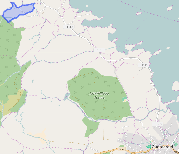
It is located at 53° 28′ 28″ N, 9° 24′ 23″ W.
Original OS map of this area
Ireland was first mapped in the 1840s. These original maps are available online.
Original OS maps at the Ordnance Survey of Ireland website
Below is a link to the Ordnance Survey of Ireland website. It displays the original OS map that was created in the 1840s.
Information from Google Maps:
You can use this link to find this townland on Google Maps.
Information from the National Monuments Service:
You can use this link to view a map of archaeological features. This link brings you to a website wherein you will have to search for your townland.
Archaeological map from the National Monuments Service
Curraghduff
I did not know what beauty was
‘Till I looked from the hills of Curraghduff
At the resting Corrib and its speckled islands
At Glann’s end the Hill of Doon
To count the sheep on the heathery slopes
To feed the horses in the stone walled paddocks
To listen to the flowing water of the mearing stream
As it tumbles to the lake to let the salmon escape
The seasons are toasted and exalted
The colours of nature bloom and are sampled
The call of the cuckoo heralding all is well
The pheasant’s cry just before its death
A majestic stag appears at dusk
Comes down the hill for better grass
Let’s off its mating roar following a doe’s scent
Its ancestors have done the same a thousand years before
I lock all this in my memory box
Let it out when the day is dark
When I sit by the fire and salute old friends
And write is all down for the grandchildren.
Jack Mc Cann
Note: The information in Italics is taken from “A Valley Remembers Glann’ printed in 2013.
Galway Library Website
http://places.galwaylibrary.ie/asp/fullresult.asp?id=52187
Townlands.ie Website
https://www.townlands.ie/galway/moycullen/kilcummin/letterfore/curraghduff-middle/


No Comments
Add a comment about this page