Clooshgereen
Antoinette Lydon


Clooshgareen is in the civil parish of Kilcummin. The civil Parish corresponds with the following Church of Ireland parish of Kilcummin, Galway West. In general the civil parish and the Church of Ireland parish are the same as is the case in the Kilcummin Oughterard area.
Clooshgereen is in the Electoral Division of Oughterard, in Civil Parish of Kilcummin, in the Barony of Moycullen, in the County of Galway
Irish form of Name: Cluais Ghéirín.
Translates to: auris Gerine, Gearins ear.
Parish: Kilcummin
Other Forms of the Name
Clooshgareen
Cluais Ghéirín
Cluais Ghéirin
Cloash Boundary Surveyors
Cluaskeareen Barony Cess Book
Cluashkeareen Local
Clusherin Barony Map
Other place names in this townland:
- Béalagrooaun Bridge (bridge)
county
barony
civil parish
townland
Cluais Chéirín/Clooshgereen
sub-units
Archival records
Area:
The land is very bad. It contains 895¾ acres of land and about 60 acres of which are under tillage with 17¾ acres of water. The remainder is mountain pasture and bog. There is nothing remarkable in this townland. It has a Trigl. point.
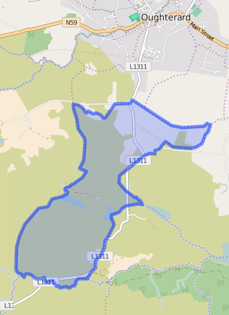
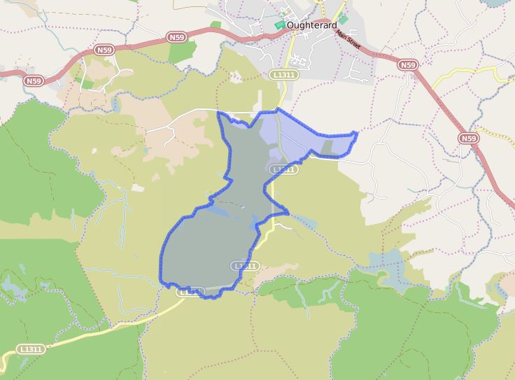
Boundaries:
Clooshgereen borders the following other townlands:
- Bunnagippaun to the south
- Carrowntober to the east
- Cregg to the north
- Luggakeeraun to the south
- Magheramore to the east
- Rusheeny to the west
Some other placenames in or near this townland are …
- Béalagrooaun Bridge (bridge)
Down’s Survey
The Down Survey is a mapped survey. Using the Civil Survey as a guide, teams of surveyors, mainly former soldiers, were sent out under Petty’s direction to measure every townland to be forfeited to soldiers and adventurers. The resulting maps, made at a scale of 40 perches to one inch (the modern equivalent of 1:50,000), were the first systematic mapping of a large area on such a scale attempted anywhere. The primary purpose of these maps was to record the boundaries of each townland and to calculate their areas with great precision. The maps are also rich in other detail showing churches, roads, rivers, castles, houses and fortifications. Most towns are represented pictorially and the cartouches, the decorative titles, of each map in many cases reflect a specific characteristic of each barony. (http://downsurvey.tcd.ie)
Townland of CLOOSHGEREEN
Down Survey Name: Mountain
1670 Owner(s): Martin, Richard (Catholic); Clanrickard, Earl of (Protestant)
County: Galway
Barony: Muckullin
Parish: Killcumyn
The Down Survey website will tell you who owned this townland in 1641 (pre Cromwell) and in 1671 (post Cromwell).
The Tithe Applotment Books
About the Records
Tithes were a tax on agricultural produce which was payable by the occupiers of agricultural land. They were the main source of income for the parish clergy of the Church of Ireland (the largest Protestant church and the church established by law). However, in many parishes a large part of the tithes were ‘appropriate’, which meant that they were payable to a bishop, cathedral chapter or other ecclesiastical recipient, or were ‘impropriate’, which generally meant that they were payable to a local landowner. The parishes used in the Tithe Applotment Books are civil or Church of Ireland parishes, which often differ in name and territory from Catholic parishes, Acts of Parliament of 1823 and 1832 provided for the conversion of tithes into a fixed charge on land, and specified the average price of wheat or oats in the parish in the seven years before 1821 as the basis on which the tithes would be calculated. They also extended the application of tithes to pasture, where previously they had been levied only on tillage.
This change in the law resulted in the valuation of individual holdings in almost all parishes containing agricultural land, in order to assess the portion of the tithes for which each occupier of land would be liable. The apportionment was recorded for each Church of Ireland parish in a Tithe Composition Applotment Book. The information was collected and the amounts were calculated by two Parochial Commissioners, one of whom was appointed by the cess-payers of the parish and the other by the relevant Diocese of the Church of Ireland. This procedure was carried out in over 2,500 parishes between the years 1823 and 1837.
The Tithe Applotment Books are in a variety of formats, from a few pages sewn together to elaborately bound volumes. In most cases they are written in manuscript throughout, although some consist of manuscript entries on printed questionnaires. The information in the books is broadly uniform and generally includes at least the name of occupier; the size of holding, the valuation and the tithe payable. In some cases more detailed information is provided. Some volumes have maps and most have certificates and correspondence attached.
The sub-divisions of the parish were recorded. Some of these subdivisions, such as ploughlands, ceased to be in official use after the six inch survey of the Ordnance Survey was completed in the 1840s. Only productive land was subject to tithe, and the books usually distinguish between this tithable land and untithable land such as roads or mountains. Tithable land was in some cases classified by quality, and a money value was given to each class. In some cases the proportion of tithe payable to the rector, vicar or lay proprietor of the tithes was set out. The column for observations was sometimes completed, with information about commonage, for example.
There are a number of other points that should be noted. The acreages given in the Tithe Applotment Books are in Irish or Plantation measure, which is 1.62 times larger than statute measure. Only occupiers of land at the time of the tithe composition are recorded, so not all heads of households living in a parish at the time are included. Only rural areas are systematically covered, although inhabitants of towns who held plots of cultivable land are included. The equivalent tax in urban areas, Minister’s Money, has left few records.
The Tithe Applotment Books are an important source of information for a wide variety of researchers of pre-Famine Ireland. They provide the first surviving national list of the occupiers of land, and are used by genealogists as a partial substitute for returns of the 1821 and 1831 censuses of population, which were destroyed in 1922. They also record information on the quality of land, and provide information on pre-Ordnance Survey territorial divisions, some of which were not recognised after the 1840s.
The National Archives hold the original Tithe Applotment Books only for the twenty-six counties of the Republic of Ireland. The books for the six counties of Northern Ireland are held in the Public Record Office of Northern Ireland in Belfast.
(http://titheapplotmentbooks.nationalarchives.ie/search/tab/aboutmore.jsp)
Tithes Applotment 1829
John Burke, James Gaughagan, Mark Molony & Patt Clancy had a total of 40 acres of land, 20 acres of 2nd quality land with a payment of 1s, 20 acres of 3rd quality land with a payment of 3d.
The Tithes payments went to Richard Martin Esq. James Daly & John Wilson.
Griffith’s Valuation
In Griffith’s valuation the area was 895 acres, 2 rood & 24 perch of land value £26 10s 0d. Value of Buildings £1 10s 0d with a total rateable value of £28 0s 0d.
Occupier of Land – William Kelly
Immediate Lessors: In fee. “in fee”, meaning that the occupier is also the legal owner of the property.
http://www.askaboutireland.ie/griffith-valuation/index.xml?action=doNameSearch&PlaceID=559789
Out Offices and Land
The out office was a farm building, a cow house, piggery or barn. The land was very poor and sterile and people were always poverty-stricken. At this time most tenants were trying to eke out a living on 5 acres or less and a farmer needed at least 15.3 acres to survive.
Poor Law Union Ireland
In Ireland the Poor Relief Act of 1838 divided into districts or “unions” in which the local taxable inhabitants were to be financially responsible for all paupers in the area. In 1898 the Poor Law Union was adopted as the basic administrative division in place of the civil parish and barony. Further subdivision into 828 registration districts and 3,751 district electoral divisions followed. Townlands were not arranged according to these divisions with parish and barony retained as a means to make comparisons with records gathered before 1898.
The 1838 Act
The main provisions of the 1838 Act were:
- The extension of the existing Poor Law Commissioners’ powers to Ireland, with the appointment of Assistant Commissioners who were to implement the Act in Ireland.
- The division of the country into Poor Law Unions based on Irish electoral divisions which were themselves made up from townlands.
- The creation of a Board of Guardians for each Union, two-thirds of whom were to be elected, the other third to be appointed ex officio.
- The setting up of a workhouse in each Union.
- The collection of a local poor-rate to finance the system.
- Assistance for emigration.
Initially, 130 Unions were created, based upon 2,049 electoral divisions. The divisions were composed of townlands, a peculiarly Irish unit, traditionally of 120 Irish acres in area. (Between 1848 and 1850, an additional 33 Unions were created by subdividing and reorganizing the boundaries of some existing Unions, particularly in the west of the country.
Boards of Guardians were elected annually on 25th March. Only rate-payers were eligible for election, which effectively disenfranchised most of the native Irish who were usually tenants at this time. Rate-payers were allowed between one and six votes depending on the size of a valuation of their property.
Townlands
A town land is one of the smallest land divisions in Ireland. They range in size from a few acres to thousands of acres. Many are Gaelic in origin, but some came into existence after the Norman invasion 1169. Clooshgareen is a town land.
Population & Census Information
- The Tithe Applotment Books
- Griffith’s Valuation
- 1901 Census
- 1911 Census
List of nineteenth century and early twentieth century inhabitants.
Census 1841-1891
1841 – 6 houses with 39 people living in Clooshgareen.
1851 – 3 houses with 25 people.
1861 – 6 houses with 31 people.
1871- 3 houses with 15 people.
1881 – 4 house with 27 people (13 males, 14 females). There were 11 out buildings. The valuation of Houses & Land in 1881 was £36.
1891 – 5 house (4 inhabited & 1 uninhabited) with 20 people (9 males, 11 females). There were 11 out buildings. The valuation of Houses & Land in 1891 was £28.
1901 Census Clooshgareen
This is a return of the member of the family, their Visitors, Boarders, and Servants who slept or abode in their house on the night of 31st of March 1901 in Clooshgareen. There were 4 houses listed in the townland of Clooshgareen. All 17 people living in Clooshgareen were Roman Catholics.
All 17 People (9 Males/8 Females) that lived in Clooshgareen were born in Co. Galway.
Enumerators Extract
http://www.census.nationalarchives.ie/reels/nai000840645/
There were a total of 5 farm buildings and out offices which included cow houses, piggeries and a calf house.
Return of Out Offices & Farm Steading
http://www.census.nationalarchives.ie/reels/nai000840647/
Class of House: The class of house depended on the materials used in the roof, walls, number of rooms and number of front windows. A 1st class house was considered the highest standard.
Walls of the houses: The walls were of stone, brick, and concrete or of mud, wood or other perishable material. The houses in Clooshgereen were built of stone, brick or concrete. There were no mud cabins.
House Occupancy: 3 houses were occupied & 1 house was uninhabited on the night of the census.
House & Building Return
http://www.census.nationalarchives.ie/reels/nai000840646/
House 1
John Walsh aged 43 was head of the family; married to Anne aged 32, they lived with their children Mary aged 7, Patk (Patrick) aged 5, Thomas aged 4, Bridget aged 3 & Anne aged 1.
John was a farmer, Mary & Patrick were scholars. John, Anne & Mary could read & write and spoke Irish & English. Patrick could read. Thomas, Bridget & baby Anne could not read. All the family was Roman Catholic.
They lived in a 3rd class house with 2 rooms & 2 front windows. They had a cow house, a calf house & a piggery. This premise was a Private Dwelling.
http://www.census.nationalarchives.ie/pages/1901/Galway/Oughterard/Clooshgereen/1394599/
House 2
John Connor aged 67 was head of the family; married to Margaret aged 60, they lived with their children Thomas aged 19, Kate aged 18 & Joseph aged 16, all single.
John was a farmer, Thomas & Joseph were agricultural labourers; Kate was a farmer’s daughter. John could read; the rest of the family could not read. The entire household spoke Irish & English.
They lived in a 3rd class house with 2 rooms & 1 front window. They had a 2 Cow houses. This premise was a Private Dwelling.
http://www.census.nationalarchives.ie/pages/1901/Galway/Oughterard/Clooshgereen/1394600/
House 3
Patk (Patrick) Connor aged 40 was head of the family; a widower, he lived with his children Michl (Michael) aged 10, Margaret aged 7, Ellen aged 5 & John aged 2.
Patrick was a farmer, Patrick & Michael spoke Irish & English. The entire family could not read or write.
They lived in a 3rd class house with 2 rooms & no front windows. They had no outbuildings. This premise was a Private Dwelling.
http://www.census.nationalarchives.ie/pages/1901/Galway/Oughterard/Clooshgereen/1394601/
House 4
Uninhabited
Census 1911 – Clooshgareen
This is a return of the Members of the families in Clooshgareen, their visitors, boarders and servants who slept or abode in the house on the night of Sunday 2nd April 1911.
There were 4 houses listed in the Townland of Clooshgareen with 18 people 10 Males & 8 Females.
18 People that lived in Clooshgareen were born included Co. Galway & Co. Limerick.
There were a total of 5 farm buildings and out offices which included a stable & cow houses.
Enumerators Extract
http://www.census.nationalarchives.ie/reels/nai002435357/
House & Building Return
http://www.census.nationalarchives.ie/reels/nai002435359/
Out Offices & Farm Steadings
http://www.census.nationalarchives.ie/reels/nai002435361/
House 1
John Burke aged 37 was head of the family; married to Agnes aged 28.
John was a land owner; he was born in Co. Galway. Agnes was born in co. Limerick. John and Agnes could read & write, they were married for 11 years.
They lived in a 2nd class house with 2 rooms & 2 front windows. They had a cow house. This premise was a Private Dwelling.
http://www.census.nationalarchives.ie/pages/1911/Galway/Oughterard/Clooshgereen/912280/
House 2
John Walsh aged 54 was head of the family; a widower. He lived with his children Mary aged 16, Pat aged 15, Thomas aged 13, Bridget aged 11, Annie aged 10, John aged 9, Nora aged 7, Peter aged 5 & Bryan aged 2.
John was a farmer; he could not read he spoke Irish & English; he was married for 17 years, having 10 children with 9 still living at the time of the census. Mary could read & write and spoke Irish & English. Pat could read & write. Thomas, Bridget, Annie, John & Nora were scholars, they could read & write. Peter & Bryan could not read.
They lived in a 2nd class house with 2 rooms & 2 front windows. They had a cow house & a stable. This premise was a Private Dwelling.
http://www.census.nationalarchives.ie/pages/1911/Galway/Oughterard/Clooshgereen/912281/
House 3
Thomas Connor aged 30 was head of the family; married to Barbara aged 29. No occupation given for Thomas. Thomas cannot read or write. Barbara could read or write. They both spoke Irish & English. They were married for 2 years.
They lived in a 3rd class house with 2 rooms & 2 front windows. They had a cow house. This premise was a Private Dwelling.
http://www.census.nationalarchives.ie/pages/1911/Galway/Oughterard/Clooshgereen/912282/
House 4
Patrick Connor aged 48 was head of the family; a widower. He lived with his children Michael aged 20, Maggie aged 17 & Ellie aged 14.
Patrick was a farmer; Michael was a farmer’s son. Patrick, Michael & Maggie could not read. Ellie could read & write. The entire household spoke Irish & English.
They lived in a 4th class house with 1 room & 1 front window. They had a cow house. This premise was a Private Dwelling.
http://www.census.nationalarchives.ie/pages/1911/Galway/Oughterard/Clooshgereen/912283/
Church records of births, deaths and marriages:
Church records of births, deaths and marriages are available online at http://www.rootsireland.ie. To search these records you will need to know the ‘church parish’ rather than the ‘civil parish’. (The civil parish is the pre-reformation parish and was frequently used as a unit of administration in the past.)
Clooshgareen is in the civil parish of Kilcummin.
Catholic parish:
This civil parish corresponds with the following Roman Catholic parish or parishes.
- Clonbern & Kilkerrin in Galway East.
- Carraroe in Galway West.
- Kilannin in Galway West.
- Kilcummin/Oughterard in Galway West.
- Rosmuc in Galway West.
Church of Ireland parish:
This civil parish corresponds with the following Church of Ireland parish.
- Kilcummin in Galway West.
In general, the civil parish and the Church of Ireland parish are the same, but, this is not always the case.
Maps:
It is located at 53° 24′ 7″ N, 9° 20′ 24″ W.
Clooshgareen
Ireland was first mapped in the 1840s. These original maps are available online.
Below is a link to the Ordnance Survey of Ireland website. It displays the original OS map that was created in the 1840s.
Information from Google Maps:
Information from the National Monuments Service:
You can use this link to view a map of archaeological features. This link brings you to a website wherein you will have to search for your townland.
Archaeological map from the National Monuments Service
Townlands.ie Website
http://www.townlands.ie/galway/moycullen/kilcummin/oughterard-ed/clooshgereen/
Galway Library Website
http://places.galwaylibrary.ie/asp/fullresult.asp?id=52081


No Comments
Add a comment about this page