Carrowndulla
Antoinette Lydon


Carrowndulla is in the civil parish of Kilcummin. The civil Parish corresponds with the following Church of Ireland parish of Kilcummin, Galway West. In general, the civil parish and the Church of Ireland parish are the same as is the case in the Kilcummin Oughterard area.
Carrowndulla is in the Electoral Division of Oughterard, in Civil Parish of Kilcummin, in the Barony of Moycullen, in the County of Galway
The Irish name for Carrowndulla is Ceathrú an Dola
Translation: flooded quarter
Parish: Kilcummin
View all place names in this civil parish.
Other Forms of the Name with the authority source Carrowndulla
Ceathramhadh an dtolla
- an dulla
Carhoondolla Boundary Surveyor
Caherundola Barony Cess book
Carrowinthollow County Map
Carhooandollo
Carhooanthuilla or flooded quarter Local
Carrowinthollow Barony Map
Area:
Carrowndulla is in the eastern part of the parish. Bounded on the North by Meagherabeg, on the West by Meagheramore, and Killannin Parish, and on the South and East by Kilannin Parish.
The land not good, it contains 156¼ acres the quarter part of which is under tillage, but it is of a very inferior quality. There are 17 acres of water included in this area. There is nothing remarkable in this townland, but an ancient fort, situated near its southern boundary.
Boundaries
Carrowndulla borders the following other townlands:
- Buffy to the west
- Drimneen to the east
- Killaguile to the east
- Raha to the north
Other placenames in this townland:
Some other placenames in or near this townland are…
- Knocknalecka (trigonometrical station)
Landlord
Proprietor Thomas B. Martin, Esq., Ballinahinch.
Thomas B. Martin of Ballynahinch Castle.
Information on the owner’s family from the Landed Estates Database;
Thomas B. Martin is a member of the Martin (Ross) family.
Martin (Ross) – The Martin family were established beside Ross Lake in the barony of Moycullen, county Galway, from the late 16th century, where they purchased land from the O’Flahertys. They were Royalist supporters and were dispossessed of their property in the city of Galway by the Cromwellians. Robert Martin received a grant of 2,909 acres in the barony of Moycullen, by patent dated 21 Aug 1677. Jasper Martin of Ross, who died in 1700, had two sons Jasper and Richard, from whom descend the two branches of the family settled at Ross and Ballynahinch. Nicholas Martin, who died in 1811, married Elizabeth O’Hara, daughter of Robert O’Hara of Lenaboy, and according to Burke’s ”Landed Gentry”, a grandniece of James O’Hara, 2nd Baron Tyrawley. Their grandson, James Martin of Ross, had sixteen children from his two marriages. His daughter, Maud, married H. Callwell and they were the parents of the author, J. M. Callwell. The youngest daughter of James Martin was Violet Florence Martin of the well-known literary team Somerville and Ross. The Martins of Ross owned 5,767 acres in county Galway in the 1870s. They advertised the sale of their estate in the Landed Estates’ Court in May 1885.
Information from the Down Survey Website:
Townland of CARROWNDULLA
Down Survey Name: Carhundolla
1641 Owner(s): Lynch, Nicholas More (Catholic)
1670 Owner(s): Martin, Robert (Catholic)
County: Galway
Barony: Muckullin
Parish: Killcumyn
Unprofitable land: 40 plantation acres
Profitable land: 52 plantation acres
Forfeited: 52 plantation acres
The Down Survey website will tell you who owned this townland in 1641 (pre Cromwell) and in 1671 (post Cromwell).
http://downsurvey.tcd.ie/landowners.php#mc=53.39271,-9.29191&z=14
The Tithe Applotment Books:
About the Records
Tithes were a tax on agricultural produce which was payable by the occupiers of agricultural land. They were the main source of income for the parish clergy of the Church of Ireland (the largest Protestant church and the church established by law). However, in many parishes a large part of the tithes were ‘appropriate’, which meant that they were payable to a bishop, cathedral chapter or other ecclesiastical recipient, or were ‘impropriate’, which generally meant that they were payable to a local landowner. The parishes used in the Tithe Applotment Books are civil or Church of Ireland parishes, which often differ in name and territory from Catholic parishes, Acts of Parliament of 1823 and 1832 provided for the conversion of tithes into a fixed charge on land, and specified the average price of wheat or oats in the parish in the seven years before 1821 as the basis on which the tithes would be calculated. They also extended the application of tithes to pasture, where previously they had been levied only on tillage.
This change in the law resulted in the valuation of individual holdings in almost all parishes containing agricultural land, in order to assess the portion of the tithes for which each occupier of land would be liable. The apportionment was recorded for each Church of Ireland parish in a Tithe Composition Applotment Book. The information was collected and two Parochial Commissioners calculated the amounts, one of who was appointed by the cess-payers of the parish and the other by the relevant Diocese of the Church of Ireland. This procedure was carried out in over 2,500 parishes between the years 1823 and 1837.
The Tithe Applotment Books are in a variety of formats, from a few pages sewn together to elaborately bound volumes. In most cases they are written in manuscript throughout, although some consist of manuscript entries on printed questionnaires. The information in the books is broadly uniform and generally includes at least the name of occupier, the size of holding, the valuation and the tithe payable. In some cases more detailed information is provided. Some volumes have maps and most have certificates and correspondence attached.
The sub-divisions of the parish were recorded. Some of these subdivisions, such as ploughlands, ceased to be in official use after the six-inch survey of the Ordnance Survey was completed in the 1840s. Only productive land was subject to tithe, and the books usually distinguish between this tithable land and untithable land such as roads or mountains. Tithable land was in some cases classified by quality, and a money value was given to each class. In some cases the proportion of tithe payable to the rector, vicar or lay proprietor of the tithes was set out. The column for observations was sometimes completed, with information about commonage, for example.
There are a number of other points that should be noted. The acreages given in the Tithe Applotment Books are in Irish or Plantation measure, which is 1.62 times larger than statute measure. Only occupiers of land at the time of the tithe composition are recorded, so not all heads of households living in a parish at the time are included. Only rural areas are systematically covered, although inhabitants of towns who held plots of cultivable land are included. The equivalent tax in urban areas, Minister’s Money, has left few records.
The Tithe Applotment Books are an important source of information for a wide variety of researchers of pre-Famine Ireland. They provide the first surviving national list of the occupiers of land, and are used by genealogists as a partial substitute for returns of the 1821 and 1831 censuses of population, which were destroyed in 1922. They also record information on the quality of land, and provide information on pre-Ordnance Survey territorial divisions, some of which were not recognised after the 1840s.
The National Archives hold the original Tithe Applotment Books only for the twenty-six counties of the Republic of Ireland. The books for the six counties of Northern Ireland are held in the Public Record Office of Northern Ireland in Belfast. (http://titheapplotmentbooks.nationalarchives.ie/search/tab/aboutmore.jsp)
Tithe Applotment Carrowndulla
Laurence Connely, John, Connely, Edmd Mealy, Matt Molloy & Mark Newell had a total of 80 acres, 10 acre of of 1st quality land with a payment of 1s 3d, 17 acres of 2nd quality land with a payment of 1s, 13 acre of 3rd quality land with a payment of 3d, 20 acres of 4th quality land with a payment of ½d and 10 acres of 5th quality land with a payment of ⅛d.
The Tithes payments went to Richard Martin Esq. Rev. James Daly & Rev. John Wilson.
http://titheapplotmentbooks.nationalarchives.ie/reels/tab//004587459/004587459_00437.pdf
Griffiths Valuation
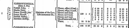
Patrick Fahy, Martin Fahy, James Newwll, Patrick Molloy & Matthias Molloy were the occupiers of the land. The Directors of the Law Life Assurance Company were the Immediate Lessor. The total area was 156 acres, 0 rood & 29 perch of houses, offices, land and water. The valuation of the land was £32 10s 0d, Buildings £2 5s 0d. Total £34 15s 0d.
http://www.askaboutireland.ie/griffith-valuation/index.xml?action=doNameSearch&PlaceID=559704
Out Offices and Land
The out office was a farm building, a cow house, piggery or barn. The land was very poor and sterile and people were always poverty-stricken. At this time most tenants were trying to eke out a living on 5 acres or less and a farmer needed at least 15.3 acres to survive.
Poor Law Union Ireland
In Ireland the Poor Relief Act of 1838 divided into districts or “unions” in which the local taxable inhabitants were to be financially responsible for all paupers in the area. In 1898 the Poor Law Union was adopted as the basic administrative division in place of the civil parish and barony. Further subdivision into 828 registration districts and 3,751 district electoral divisions followed. Townlands were not arranged according to these divisions with parish and barony retained as a means to make comparisons with records gathered before 1898.
The 1838 Act
The main provisions of the 1838 Act were:
- The extension of the existing Poor Law Commissioners’ powers to Ireland, with the appointment of Assistant Commissioners who were to implement the Act in Ireland.
- The division of the country into Poor Law Unions based on Irish electoral divisions which were they made up from townlands.
- The creation of a Board of Guardians for each Union, two-thirds of whom were to be elected, the other third to be appointed ex officio.
- The setting up of a workhouse in each Union.
- The collection of a local poor-rate to finance the system.
- Assistance for emigration.
Initially, 130 Unions were created, based upon 2,049 electoral divisions. The divisions were composed of townlands, a peculiarly Irish unit, traditionally of 120 Irish acres in area. (Between 1848 and 1850, an additional 33 Unions were created by subdividing and reorganizing the boundaries of some existing Unions, particularly in the west of the country.
Boards of Guardians were elected annually on 25th March. Only ratepayers were eligible for election, which effectively disenfranchised most of the native Irish who were usually tenants at this time. Ratepayers were allowed between one and six votes depending on the size of a valuation of their property.
Townlands
A town land is one of the smallest land divisions in Ireland. They range in size from a few acres to thousands of acres. Many are Gaelic in origin, but some came into existence after the Norman invasion 1169. Carrowndulla is a Townland.
Population and Census Information
People who lived here:
You can retrieve a list of people who lived in this townland from 1827 to 1911. This list is compiled from the following resources.
- The Tithe Applotment Books
- Griffith’s Valuation
- 1901 Census
- 1911 Census
List of nineteenth century and early twentieth century inhabitants.
Census 1841 – 1911
1841 28 houses with 130 people living in Carrowndulla.
1851 14 houses with 70 people.
1861 15 houses with 76 people.
1871 16 houses with 47 people
1881 10 houses with 21 people (21 males & 10 females). 5 houses were occupied and 5 were unoccupied. There was 2 out offices/farm steadings. The valuation of Houses & Land in 1881 was £33 15s 0d.
1891 5 houses with 13 people (6 males & 7 females). 4 houses were occupied and 1 was unoccupied. There was 4 out offices/farm steadings. The valuation of Houses & Land in 1881 was £33 10s 0d.
1901 Census
This is a return of the member of the family, their Visitors, Boarders, and Servants who slept or abode in their house on the night of 31st of March 1901 in Carrowndulla. There were 5 houses listed in the townland of Carrowndulla. 13 (6 females/ 7 males) were all Roman Catholics. All the people that lived in Carrowndulla were born in Co. Galway.
There were a total of 5 farm buildings and out offices which included stable, cow houses & piggeries.
Class of House: The class of house depended on the materials used in the roof, walls, number of rooms and number of front windows. A 1st class house was considered the highest standard.
Walls of the houses: The walls were of stone, brick, and concrete or of mud, wood or other perishable material. The house in Carrowndulla was built of stone, brick or concrete. There were no mud cabins.
Enumerators Extract
http://www.census.nationalarchives.ie/reels/nai000840623/
House & Building Return
http://www.census.nationalarchives.ie/reels/nai000840624/
Return of Out Offices & Farm Steadings
http://www.census.nationalarchives.ie/reels/nai000840625/
House 1
Bridget Newell aged 65 was head of the family; a widow, she lived with her son James aged 29, single.
Bridget was a farmeress and James was a farmer’s son. Briget could not read; James could read and write; both spoke Irish & English.
They lived in a 3rd class house with 2 rooms and no front window. They had a cow house & a piggery.
http://www.census.nationalarchives.ie/pages/1901/Galway/Oughterard/Carrowndulla/1394589/
House 2
John Lydon aged 38 was head of family, he lived with his brother Thomas aged 36, both single.
John was a herd and Thomas was a herds brother. John could read and write; Thomas could not read. Both spoke Irish & English.
They lived in a 3rd class house with 2 rooms and 1 front window. They had a piggery.
http://www.census.nationalarchives.ie/pages/1901/Galway/Oughterard/Carrowndulla/1394590/
House 3
Sarah Hanly aged 60 was head of the family; a widow. She lived with her son John aged 30.
Sarah was a housekeeper and John was an agricultural labourer. They could not read. Sarah spoke only Irish. John spoke Irish & English.
They lived in a 4th class house with 1 room and no front window. They had no out buildings.
http://www.census.nationalarchives.ie/pages/1901/Galway/Oughterard/Carrowndulla/1394591/
House 4
Patk Fahy aged 40 was head of the family, married to Bridget aged 40. They lived with their children Maggie aged 12, Mary aged 10, Martin aged 8, Bridget aged 6 and Thomas aged 3.
Patk was a farmer. Maggie, Mary & Martin were scholars. Patk, Maggie & Mary could read and write. Bridget (mother), Bridget (daughter) and Thomas could not read. Martin could read. Patk spoke Irish & English. Bridget (mother) spoke only Irish. There is no record on the census return of what languages the children spoke.
They lived in a 2nd class house with 2 rooms and 3 front windows. They had a cow house.
http://www.census.nationalarchives.ie/pages/1901/Galway/Oughterard/Carrowndulla/1394592/
House 5
This was a Cornmill. It had a stable. This information was taken from the House & Building Return.
1911 Census
This is a return of the Members of the families in Carrowndulla, their visitors, boarders and servants who slept or abode in the house on the night of Sunday 2nd April 1911.
There were 5 houses listed in the Townland of Carrowndulla. Of the people living in Carrowndulla all 27(15 males/12 females) were Roman Catholics.
People that lived in Carrowndulla were born included Co. Galway. There were a total of 8 farm buildings and out offices included a stable, barn, shed & cow houses.
Enumerators Extract
http://www.census.nationalarchives.ie/reels/nai002435321/
House & Building Returns
http://www.census.nationalarchives.ie/reels/nai002435321/
Out Offices & Farm Steadings
http://www.census.nationalarchives.ie/reels/nai002435325/
House 1
Patrick Fahy aged 58 was head of the family, married to Bridget aged 54. They lived with their children Mary aged 20, Martin aged 18, Bridget aged 16 and Thomas aged 14.
Patrick was a farmer. Patrick, Mary, Martin, Bridget (daughter) and Thomas could read and write. Patrick, Mary, Martin, Bridget & Thomas spoke Irish & English. Bridget (mother) could not read or write, she spoke only Irish.
Patrick & Bridget were married for 23 years; they had 5 children with all 5 still living at the time of the census.
They lived in a 3rd class house with 2 rooms and 1 front windows. They had a cow house and a piggery.
http://www.census.nationalarchives.ie/pages/1911/Galway/Oughterard/Carrowndulla/912274
House 2
John Lyden aged 50 was head of family, he lived with his brother Thomas aged 48, both single.
John was a herd. John & Thomas could not read and write. Both spoke Irish & English.
They lived in a 3rd class house with 1 room and 1 front window. They had a fowl house.
There surname was listed as Lydon in the 1901 Census and is the most common spelling of the surname in this area.
http://www.census.nationalarchives.ie/pages/1911/Galway/Oughterard/Carrowndulla/912275/
House 3
Bridget Newell aged 74 was head of the family; a widow, she lived with her son James aged 38, single.
Bridget was a farmer and James was a farmer’s son. Briget could not read; James could read and write; both spoke Irish & English.
They lived in a 4th class house with 1 room and no front window. They had no outbuildings.
Bridget was married for 19 years; she had 4 children with 1 still living at the time of the census.
http://www.census.nationalarchives.ie/pages/1911/Galway/Oughterard/Carrowndulla/912276/
People who lived here:
You can retrieve a list of people who lived in this townland from 1827 to 1911. This list is compiled from the following resources.
- The Tithe Applotment Books
- Griffith’s Valuation
- 1901 Census
- 1911 Census
List of nineteenth century and early twentieth century inhabitants.
Church records of births, deaths and marriages:
Church records of births, deaths and marriages are available online at http://www.rootsireland.ie. To search these records, you will need to know the ‘church parish’ rather than the ‘civil parish’. (The civil parish is the pre-reformation parish and was frequently used as a unit of administration in the past.)
Carrowndulla is in the civil parish of Kilcummin.
Catholic parish:
This civil parish corresponds with the following Roman Catholic parish or parishes.
- Clonbern & Kilkerrin in Galway East.
- Carraroe in Galway West.
- Kilannin in Galway West.
- Kilcummin/Oughterard in Galway West.
- Rosmuc in Galway West.
Church of Ireland parish:
This civil parish corresponds with the following Church of Ireland parish.
- Kilcummin in Galway West.
In general, the civil parish and the Church of Ireland parish are the same, but this is not always the case.
Map
It is located at 53° 23′ 31″ N, 9° 17′ 32″ W.
Original OS map of this area
Ireland was first mapped in the 1840s. These original maps are available online.
Original OS maps at the Ordnance Survey of Ireland website
Below is a link to the Ordnance Survey of Ireland website. It displays the original OS map that was created in the 1840s.
Information from Google Maps:
You can use this link to find this townland on Google Maps.
Information from the National Monuments Service:
You can use this link to view a map of archaeological features. This link brings you to a website wherein you will have to search for your townland.
Archaeological map from the National Monuments Service
Townlands.ie Website
http://www.townlands.ie/galway/moycullen/kilcummin/oughterard/carrowndulla/
Galway Library Website
http://places.galwaylibrary.ie/asp/fullresult.asp?id=52044


No Comments
Add a comment about this page