Canrawer West
Treasa NicDhonncha & Antoinette Lydon


Canrawer West is in the civil parish of Kilcummin. The civil parish corresponds with the following Church of Ireland parish of Kilcummin, Galway West. In general, the civil parish and the Church of Ireland parish are the same as is the case in the Kilcummin Oughterard area.
Irish Form of Name: Ceann Ramhar
Translation: thick head.
Canrawer West is in the Electoral Division of Oughterard, in Civil Parish of Kilcummin, in the Barony of Moycullen, in the County of Galway
O’Donovan’s Field Name Books
Other Forms of the Name:
Kanrawer West Kanrawer West Boundary Surveyor Canrawer Barony Cess Book N. & W. Caneraver alias Canrower J. O’Flaherty, Esq., Proprietor Canrawer West Local
Description:
Present proprietor Captain O’Flaherty, Lemonfield. Containing 140 acres of land about 60 acres under tillage and 6½ acres composed of water, the remainder is bog. There is a corn mill, Spa Well, Waterfall and Eel Weir, the two former are close to its N.W. boundary and the two latter on it, also a cave a and village near its eastern boundary.
Situation:
In the northern extremity of the parish.
This is a list of townlands that share a border with this townland.
Proprietor:
Captain O’Flaherty of Lemonfield
O’Flaherty is a member of the O’Flahertie (Lemonfield) family.
Landed Estates Database:
The O’Flaherties of Lemonfield are descended from the O’Flaherties of Aughnenure Castle near Oughterard, county Galway. Their estate was in the parish of Kilcummin, barony of Moycullen, county Galway, and Lemonfield, close to the village of Oughterard, was their seat from the mid18th century. There are some 17th and 19th century records relating to them in the Westport Papers. The O’Flahertie estate of over 4500 acres was advertised for sale in 1854 and a reduced acreage of 2346 acres in 1864. Both rentals included lead mines and a black marble quarry. The Irish Times reports that the 1864 sale saw many of the lots bought by a Mr. Carpenter. In the 1870s the O’Flahertie’s owned 2340 acres in county Galway. By March 1916 they had accepted offers from the Congested Districts’ Board for parts of their estate.
Down Survey
The Down Survey is a mapped survey. Using the Civil Survey as a guide, teams of surveyors, mainly former soldiers, were sent out under Petty’s direction to measure every townland to be forfeited to soldiers and adventurers. The resulting maps, made at a scale of 40 perches to one inch (the modern equivalent of 1:50,000), were the first systematic mapping of a large area on such a scale attempted anywhere. The primary purpose of these maps was to record the boundaries of each townland and to calculate their areas with great precision. The maps are also rich in other detail showing churches, roads, rivers, castles, houses and fortifications. Most towns are represented pictorially and the cartouches, the decorative titles, of each map in many cases reflect a specific characteristic of each barony. (http://downsurvey.tcd.ie)
Down Survey Information on Canrawer West
Down Survey Name: Canrowre 1641 Owner(s): Clanrickard, Earl of (Protestant) 1670 Owner(s): Clanrickard, Earl of (Protestant) County: Galway Barony: Muckullin Parish: Killcumyn Unprofitable land: 106 plantation acres Profitable land: 54 plantation acres Forfeited: 54 plantation acres
The Tithe Applotment Books
About the Records
Tithes were a tax on agricultural produce which was payable by the occupiers of agricultural land. They were the main source of income for the parish clergy of the Church of Ireland (the largest Protestant church and the church established by law). However, in many parishes a large part of the tithes were ‘appropriate’, which meant that they were payable to a bishop, cathedral chapter or other ecclesiastical recipient, or were ‘impropriate’, which generally meant that they were payable to a local landowner. The parishes used in the Tithe Applotment Books are civil or Church of Ireland parishes, which often differ in name and territory from Catholic parishes,
Acts of Parliament of 1823 and 1832 provided for the conversion of tithes into a fixed charge on land, and specified the average price of wheat or oats in the parish in the seven years before 1821 as the basis on which the tithes would be calculated. They also extended the application of tithes to pasture, where previously they had been levied only on tillage.
This change in the law resulted in the valuation of individual holdings in almost all parishes containing agricultural land, in order to assess the portion of the tithes for which each occupier of land would be liable. The apportionment was recorded for each Church of Ireland parish in a Tithe Composition Applotment Book. The information was collected and the amounts were calculated by two Parochial Commissioners, one of whom was appointed by the cess-payers of the parish and the other by the relevant Diocese of the Church of Ireland. This procedure was carried out in over 2,500 parishes between the years 1823 and 1837.
The Tithe Applotment Books are in a variety of formats, from a few pages sewn together to elaborately bound volumes. In most cases they are written in manuscript throughout, although some consist of manuscript entries on printed questionnaires. The information in the books is broadly uniform and generally includes at least the name of occupier; the size of holding, the valuation and the tithe payable. In some cases more detailed information is provided. Some volumes have maps and most have certificates and correspondence attached.
The sub-divisions of the parish were recorded. Some of these subdivisions, such as ploughlands, ceased to be in official use after the six-inch survey of the Ordnance Survey was completed in the 1840s. Only productive land was subject to tithe, and the books usually distinguish between this tithable land and untithable land such as roads or mountains. Tithable land was in some cases classified by quality, and a money value was given to each class. In some cases, the proportion of tithe payable to the rector, vicar or lay proprietor of the tithes was set out. The column for observations was sometimes completed, with information about commonage, for example.
There are a number of other points that should be noted. The acreages given in the Tithe Applotment Books are in Irish or Plantation measure, which is 1.62 times larger than statute measure. Only occupiers of land at the time of the tithe composition are recorded, so not all heads of households living in a parish at the time are included. Only rural areas are systematically covered, although inhabitants of towns who held plots of cultivable land are included. The equivalent tax in urban areas, Minister’s Money, has left few records.
The Tithe Applotment Books are an important source of information for a wide variety of researchers of pre-Famine Ireland. They provide the first surviving national list of the occupiers of land, and are used by genealogists as a partial substitute for returns of the 1821 and 1831 censuses of population, which were destroyed in 1922. They also record information on the quality of land, and provide information on pre-Ordnance Survey territorial divisions, some of which were not recognised after the 1840s.
The National Archives hold the original Tithe Applotment Books only for the twenty-six counties of the Republic of Ireland. The books for the six counties of Northern Ireland are held in the Public Record Office of Northern Ireland in Belfast. (http://titheapplotmentbooks.nationalarchives.ie/search/tab/aboutmore.jsp)
Tithe Applotment Record for Canrawer West
Landholders
Listed in the Tithe Applotment book for Canrawer West in 1829 were: Martin Naughton, Michl Comy, Michael Walsh and James Walsh.
Land Liable for Tithe
The total land liable for tithes in Canrawer West was 20 acres. This was broken up into five separate columns according to the quality of land. In Canrawer West there was no 1st or 5th quality land.
- 7 acres of 2nd rate quality land with a tithe of 1s per acre.
- 7 acres of 3rd rate quality land with a tithe of 3d per acre.
- 6 acres of 4th rate quality land with a tithe of ½ d per acre.
Tithes Payable
The proportion of tithes payable to Richard Martin Esq. was 4s 6d per acre, the proportion of tithes payable to Reverend James Daly was 2s 3d, and the proportion of tithes payable to Reverend John Wilson was 2s 3d.
http://titheapplotmentbooks.nationalarchives.ie/search/tab/results.jsp?county=Galway&parish=Kilcummin&townland=West Kanerour&search=Search&sort=last_name_sort
http://titheapplotmentbooks.nationalarchives.ie/reels/tab//004587459/004587459_00442.pdf
Griffith’s Valuation 1850s
In Griffith’s Valuation the area prior to exemptions was 146 acres 2 roods and 7 perches with a land value of £22 1s 0d and a building value of £25 10s 0d with a total value of £48. The Excise Barrack, yard and Garden was exempt and consisted of 20 perches with a building value of £4 17s 0d. the graveyard was also exempt and consisted of 1 acre and 3 perches with a land value of 10s. After that was deducted the total area was 145 acres 1 roods and 24 perches with a land value of £21 8s 0d and a total building value of £21 2s 0d with a total value of £42 10s 0d. The total area of water was 2 roods.
Occupiers of the Land:
There were 3 different Landlords of immediate leasers of the land
Landlord or immediate leaser – George F. Flahertie
The occupiers of the land at this time were: John Naughton, Michael Phillips, Michael Higgins, Patrick Naughton, Bridget Naughton, John Neville, Patrick Cooney, Edward Cooney, John Curley, William Hicks, Patrick Healey, Michael Walsh, Peter Walsh, Willaim Glynn, John Davis, Michael Walsh, Catherine Faherty, Peter Walsh and Guardians of the Poor of Oughterard Union.
Landlord or immediate leaser – William Glynn
The occupier of the land were: Board of Excise
Landlord or immediate leaser – Michael Walsh
The occupiers of the land were Ellen Dowd and Anne Devine
Ownership of Land and Property
John Naughton, Michael Phillips, Michael Higgins, Patrick Naughton, Bridget Naughton, John Neville, Patrick Cooney, Edward Cooney, John Curley, Patrick Healey, Michael Walsh, Catherine Faherty and Peter Walsh each owned a house and land. William Hicks owned a linen factory and land. Michael Walsh owned a house, corn mill and land. William Glynn owned land and a house and land. Peter Walsh and owned land. Ellen Dowd and Anne Devine owned a house each. The Board of Excise owned a Barrack, yard and garden consisting of 20 perches. The Guardian of the Poor of Oughterard Union owned a Graveyard consisting of 1 acre and 3 perches.
Annual Valuation
The total annual valuation of rateable property after exemptions were deducted in Canrawer West came to £42 10s 0d
Land Rates: John Naughton, Michael Phillips, Michael Higgins, Patrick Naughton, Bridget Naughton, John Neville, Edward Cooney, John Curley and John Davis each paid £1. Patrick Cooney paid £2. Willam Hicks and Michael Walsh paid 5s. Patrick Healey paid £2 10s. Peter Walsh paid £5. William Glynn paid 15s and 8 s. The Board of Excise paid 3s but was excempt. Michael Walsh and Peter Walsh each paid 10s. Guardians of the Poor of Oughterard Union paid 10s but was excempt. Catherine Faherty paid 5s/
Building Rates: John Naughton, Michael Phillips, Michael Higgins, Patrick Naughton, Bridget Naughton, John Neville, Edward Cooney and John Curley each paid 5s. Patrick Cooney paid 10s. William Hicks paid 15s. Patrick Healey paid 10s. Michael Walsh paid £1 5s. William Glynn paid 17s. The Board of Excise paid £4 17s but was exempt. Michael Walsh paid £1 10s. Ellen Dowd and Anne Devine each paid 15s. Catherine Faherty paid £1. Peter Walsh paid £2.
Out Offices and Land
The out office was a farm building, a cow house, piggery or barn. The land was very poor and sterile and people were always poverty-stricken. At this time most tenants were trying to eke out a living on 5acres or less and farmers needed at least 15.3 acres to survive.
Poor Law Union Ireland
In Ireland the Poor Relief Act of 1838 divided into districts or “unions” in which the local taxable inhabitants were to be financially responsible for all paupers in the area. In 1898 the Poor Law Union was adopted as the basic administrative division in place of the civil parish and barony. Further subdivision into 828 registration districts and 3,751 district electoral divisions followed. Townlands were not arranged according to these divisions with parish and barony retained as a means to make comparisons with records gathered before 1898.
The 1838 Act
The main provisions of the 1838 Act were:
- The extension of the existing Poor Law Commissioners’ powers to Ireland, with the appointment of Assistant Commissioners who were to implement the Act in Ireland.
- The division of the country into Poor Law Unions based on Irish electoral divisions which were themselves made up from townlands.
- The creation of a Board of Guardians for each Union, two-thirds of whom were to be elected, the other third to be appointed ex officio.
- The setting up of a workhouse in each Union.
- The collection of a local poor-rate to finance the system.
- Assistance for emigration.
Initially, 130 Unions were created, based upon 2,049 electoral divisions. The divisions were composed of townlands, a peculiarly Irish unit, traditionally of 120 Irish acres in area. (Between 1848 and 1850, an additional 33 Unions were created by subdividing and reorganizing the boundaries of some existing Unions, particularly in the west of the country.
Boards of Guardians were elected annually on 25th March. Only rate-payers were eligible for election, which effectively disenfranchised most of the native Irish who were usually tenants at this time. Rate-payers were allowed between one and six votes depending on the size of a valuation of their property.
Census 1881/ 1891
The Table shows that there were 4 Registrar’s Districts and Electoral Divisions in the Oughterard Poor Law Union. The total area of the whole Union was 172,289 acres. The table gives the number of houses and the population for each district from 1841, 1851, 1861, 1871, 1881, to 1891.The divisions of the Oughterard Union were Kilcummin, Letterfore, Oughterard and Wormhole. The total numbers of houses listed in 1841 were 4,465 and by 1881 there were 3,641 houses. The population in 1871 was 19,572 and by 1891 it was 18,975.
Townlands
A town land is one of the smallest land divisions in Ireland. They range in size from a few acres to thousands of acres. Many are Gaelic in origin, but some came into existence after the Norman invasion 1169. Canrawer West is a townland.
Population & Census Information
People who lived here:
You can retrieve a list of people who lived in this townland from 1827 to 1911. This list is compiled from the following resources.
- The Tithe Applotment Books
- Griffith’s Valuation
- 1901 Census
- 1911 Census
List of nineteenth century and early twentieth century inhabitants of this townland.
1841-1891 Census
1841 – 14 houses with 69 people living in Canrawer West
1851 – 19 houses with 88 people,
1861 – 18 houses with 87 people,
1871 – 16 houses with 86 people,
1881- 20 houses (15 inhabited) with 80 people (38 males, 42 females). There were 15 outbuildings.
The valuation of Houses & Land in 1881 was £46 13s 0d.
1891 – 18 houses (18 inhabited) with 84 people (41 males, 43 females). There were 6 outbuildings.
The valuation of Houses & Land in 1891 was £41 2s 0d.
1901 Census
This is a return of the members of the family, their Visitors, Boarders, Servants who slept or abode in their house on the night of Sunday March 31st 1901 in Canrawer West.
General Information
There were 20 buildings listed in the townland of Canrawer West. All the houses were listed as private dwellings and were occupied by 1 family. 5 of the houses were not occupied.
http://www.census.nationalarchives.ie/reels/nai000840583/
http://www.census.nationalarchives.ie/reels/nai000840584/
Farm Buildings and Out Offices
There were 13 out offices and farm steadings in the townland. Page 2 from the Out is not available on the National Archives of Ireland Website, this page contains the details on the outbuildings for houses 16 through to 21.
http://www.census.nationalarchives.ie/reels/nai000840585/
Description of the Houses
Class of House: The class of house depended on the materials used in the roof, walls, number of rooms and number of front windows. A 1st class house was considered the highest standard.
Walls of the houses: The walls were of stone, brick, and concrete or of mud, wood or other perishable material. The houses in Canrawer West were built of stone, brick or concrete. There were no mud cabins.
Roofs: Roofs were of slate, iron, tiles, thatch, wood or other perishable material. 7 of the buildings had roofs of thatch, wood or perishable material. They were most likely thatched. The other buildings were of slate, iron or tile.
House Occupancy
All of the buildings were listed as private dwellings and were occupied by 1 family. 5 of the houses were uninhabited. The people listed as the head of the family was also listed as the lawful landholder with the exception of house No. 1, 4, 6, 7, 8, 9, 11 and 16 (see below). There was a total population of 79, with 41 males and 38 females residing in the townland. Everyone was Roman Catholic. Everyone, apart from 1 person who was born in England, was born in Co Galway.
Enumerator’s Extract
http://www.census.nationalarchives.ie/reels/nai000840582/
House No. 1 (3 occupants)
John Joyce aged 62 was the head of the family. He was a stonemason and had 1 piggery. John was a widower and lived with his sons John aged 32 who was also a stonemason and Thomas aged 27 who was a postman. They were both single. John and his son John could not read, Thomas could read and write. They all spoke Irish and English. They were all Born in Ardnasella in Co Galway. They lived in a class 3 house with 1 front window. 3 people occupied 2 available rooms. The legal landholder was John P O’Flahertie.
http://www.census.nationalarchives.ie/pages/1901/Galway/Oughterard/Canrower_West/1394566/
House No. 2 (0 occupants)
The house was not inhabited. The legal landholder was Thomas F. Naughton.
House No. 3 (5 occupants)
Thomas Devaney aged 29 was the head of the family. He lived with his wife Bridget aged 26. Thomas was an Agricultural Labourer and had no out buildings. Also living in the house were his son Joseph aged 6 and his daughters Mary aged 5 and Kate aged 1. Joseph and Mary were scholars. Thomas and Bridget could read and write and spoke Irish and English. The children could not read and Joseph and Mary spoke English. Kate was listed as not talking. They lived in a class 3 house with no front windows listed. 5 people occupied 3 available rooms.
http://www.census.nationalarchives.ie/pages/1901/Galway/Oughterard/Canrower_West/1394567/
House No. 4 (2 occupants)
Patrick Faherty aged 60 was the head of the family. He lived with his wife Bridget aged 50. Patrick was a labourer and Bridget was a housekeeper. They had no out buildings. They could not read and write and they spoke Irish and English. They lived in a class 3 house with no front windows listed. 2 people occupied 1 available room. They legal landholder was John P. O’Flahertie.
http://www.census.nationalarchives.ie/pages/1901/Galway/Oughterard/Canrower_West/1394568/
House No. 5 (0 occupants)
The house was not inhabited. The legal landholder was John P. O’Flahertie.
House No. 6 (4 occupants)
Peter Walsh aged 71 was the head of the family. He lived with his wife aged 64. Peter was a labourer and Margaret was a housekeeper. He had 1 piggery. Also living in the house were his son Tom aged 27 who was a labourer and his daughter Maggie aged 29 who was a dressmaker. They were both unmarried. Peter spoke Irish, Margaret, Tom and Maggie spoke Irish and English. Neither Peter nor Margaret could read, Tom and Maggie could read and write. They lived in a class 3 house with no front window listed. 4 people occupied 2 available rooms. The legal landholder was John P. O’Flahertie.
http://www.census.nationalarchives.ie/pages/1901/Galway/Oughterard/Canrower_West/1394569/
House No. 7 (3 occupants)
Pat Keeler aged 40 was the head of the family. He was a butcher and had no out building. Pat was not married and lived with his sister Barbara Welby aged 38 and his nephew John Ryan aged 17. Barbara was a widow and worked as a washer woman. John was a labourer. Pat and John could read and write, Barbara could not read. They all spoke Irish and English. They lived in a class 3 house with no front window listed. 3 people occupied 1 available room. The legal landholder was John P. O’Flahertie.
http://www.census.nationalarchives.ie/pages/1901/Galway/Oughterard/Canrower_West/1394570/
House No. 8 (9 occupants)
Martin Halloran aged 36 was the head of the family. He lived with his wife Sarah aged 36. Martin was an agricultural labourer and Sarah was a house keeper. He had 1 piggery. Also living in the house were his son Patrick aged 15, daughters Anne aged 13, and Mary aged 10, son Edmund aged 7, daughter Bridget aged 5 and sons Michael aged 4 and Martin aged 3. Patrick was an agricultural labourer, the rest of the children, apart from Martin, were scholars. Martin, Sarah, Patrick and the three youngest children could not read. Edmund could read, Anne and Mary could read and write. Martin, Sarah, Patrick, Anne and Mary spoke Irish and English. This information is not given for the rest of the children. They lived in a class 3 house with no front window listed. 9 people occupied 2 available rooms. The legal landholder was John P. O’Flahertie.
http://www.census.nationalarchives.ie/pages/1901/Galway/Oughterard/Canrower_West/1394571/
House No. 9 (5 occupants)
Martin Murray aged 31 was the head of the family. He lived with his wife Mary aged 27. Martin was a general labourer and Mary was a housekeeper. He had no out building. Also living in the house were his daughter Mary aged 6 and his sons Christy aged 4 and Patrick aged 2. Mary was a scholar. Martin and his daughter Mary could read, his wife and sons could not read. Martin and Mary spoke Irish and English; this information is not given for the children. 5 people occupied 2 available rooms. The legal landholder was John P. O’Flahertie.
http://www.census.nationalarchives.ie/pages/1901/Galway/Oughterard/Canrower_West/1394572/
House No. 10 (0 occupants)
The house was not inhabited. The legal landholder was John P. O’Flahertie.
House No. 11 (2 occupants)
Henry Green aged 65 was the head of the family. He was born in England. Henry lived with his wife Margaret aged 60. He was a general labourer and Margaret was a housekeeper. He had no out building. Neither of them could read. Margaret spoke Irish and England. The language information for Henry was not filled in. Henry was blind in his left eye. They lived in a class 3 house with 1 front window. 2 people occupied 1 available room.
http://www.census.nationalarchives.ie/pages/1901/Galway/Oughterard/Canrower_West/1394573/
House No. 12 (3 occupants)
Patrick Hefferan aged 29 was the head of the family. He lived with his wife Nappie aged 35. Patrick was a labourer and Nappie was a dressmaker. He had 1 barn. Also living in the house was his daughter Mary aged 8. Mary was a scholar. Everyone in the house could read and write. They all spoke English, Nappie and Mary spoke Irish and English. They lived in a class 2 house with 2 front windows. 3 people occupied 2 available rooms.
http://www.census.nationalarchives.ie/pages/1901/Galway/Oughterard/Canrower_West/1394574/
House No. 13 (0 occupants)
The house was not inhabited. The legal landholder was John Thomas Newell.
House No. 14 (6 occupants)
Edmond Cooney aged 72 was the head of the family. He lived with his wife Honor aged 68. Edmond was a farmer and had 1 piggery. Also living in the house was his daughter Mary Faherty aged 23 and his son in law James Faherty aged 26. Mary was a housekeeper and James was an agricultural labourer. Edmond’s granddaughter Bridget Faherty aged 2 and his grandson Patrick Faherty aged 5 months also lived in the house. James and Mary could read and write no one else could read. Everyone apart from the children spoke Irish and English. They lived in a class 3 house with 1 front window. 6 people occupied 2 available rooms.
http://www.census.nationalarchives.ie/pages/1901/Galway/Oughterard/Canrower_West/1394575/
House No. 15 (2 occupants)
Bridget Devaney aged 79 was the head of the family. She was a housekeeper and had no out building. Bridget was a widow and lived with her daughter Mary aged 50. Mary was not married and worked as a general servant domestic. They could not read and they both spoke Irish and English. They lived in a class 3 house with no front window listed. 2 people occupied 2 available rooms.
http://www.census.nationalarchives.ie/pages/1901/Galway/Oughterard/Canrower_West/1394576/
House No. 16 (4 occupants)
Martin Phillips aged 60 was the head of the family. He lived with his wife Mary aged 60. Martin was an agricultural labourer and Mary was housekeeper. He had no out building. Also living in the house were his daughter Mary aged 30 and his son John aged 26. Mary worked as a washer woman and John was an agricultural labourer. They were both unmarried Only John could read and write, no one else could read. They all spoke Irish and English. They lived in a class 4 house with no front window listed. 4 people occupied 1 available room. The legal landholder was John P. O’Flahertie.
http://www.census.nationalarchives.ie/pages/1901/Galway/Oughterard/Canrower_West/1394577/
House No. 17 (12 occupants)
John Naughton aged 46 was the head of the family. He lived with his wife Bridget aged 42. John was a farmer and had 2 outbuildings. Also living in the house were his son Patrick aged 18, his daughter Mary aged 16, his sons Michael aged 14 and Peter aged 13, his daughters Bridget aged 11, Margaret aged 9 and Ellen aged 7, his sons John aged 5 and Hugh aged 3 and his daughter Hanoria aged 6 months. They lived in a class 2 house with 3 front windows. 12 people occupied 3 available rooms. Patrick worked as an agricultural labourer, Mary and Michael were listed as a farmer’s daughter and son and all the other children apart from the two youngest were scholars. Everyone in the house apart from the three youngest children could read and write. John could read. Everyone apart from the three youngest children spoke Irish and English. They lived in a class 2 house with 3 front windows. 12 people occupied 3 available rooms.
http://www.census.nationalarchives.ie/pages/1901/Galway/Oughterard/Canrower_West/1394579/
House No. 18 (3 occupants)
Patrick Rubbary aged 65 was the head of the family. He lived with his wife Julia aged 65. Patrick was an agricultural labourer and Julia was a housekeeper. He had 2 outbuildings. Also living in the house was his son Martin aged 30. Martin was not married and also worked as an agricultural labourer. Neither Patrick nor Julia could read, Patrick could read and write. Everyone spoke Irish and English. They lived in a class 3 house with no front window listed. 3 people occupied 2 available rooms.
http://www.census.nationalarchives.ie/pages/1901/Galway/Oughterard/Canrower_West/1394579/
House No. 19 (11 occupants)
Michael Naughton aged 50 was the head of the family. He lived with his wife Mary aged 42. Michael was a farmer and had 4 outbuildings. Also living in the house were his sons John aged 19, David aged 17 and Peter aged 15, his daughters Hannah Maria aged 14, Sarah aged 11 and Ellen aged 10, his sons Michael aged 9, Patrick aged 7 and Thomas aged 4. John and David worked as agricultural labourers, Peter was a farmer’s son and the rest of the children apart from the youngest, Thomas, were scholars. Michael and his son Patrick could read, Mary and her son Thomas could not read, everyone else could read and write. Everyone apart from the three youngest children spoke Irish and English. This information is not given for the youngest children. They lived in a class 3 house with 1 front window. 11 people occupied 3 available rooms.
http://www.census.nationalarchives.ie/pages/1901/Galway/Oughterard/Canrower_West/1394580/
House No. 20 (5 occupants)
Thomas Newell aged 50 was the head of the family. He lived with his wife Kate aged 45. Thomas was a farmer and had 2 outbuildings. Also living in the house were his daughters Margaret aged 19, Ellen aged 15 and Honor aged 13. Margaret was a farmer’s daughter and Ellen and Honor were scholars. Neither Thomas nor Kate could read, their daughters could read and write. Everyone spoke Irish and English. They lived in a class 4 house with no front window listed. 5 people occupied 1 available room.
http://www.census.nationalarchives.ie/pages/1901/Galway/Oughterard/Canrower_West/1394581/
House No. 21 (0 occupants)
The house was not inhabited. The legal landholder was John P. O’Flahertie.
Church records of births, deaths and marriages:
Church records of births, deaths and marriages are available online at http://www.rootsireland.ie To search these records, you will need to know the ‘church parish’ rather than the ‘civil parish’. (The civil parish is the pre-reformation parish and was frequently used as a unit of administration in the past.)
Canrawer West is a townland.
Roman Catholic parishes:
This civil parish corresponds with the following Roman Catholic parish or parishes.
- Carraroe
- Kilannin
- Kilcummin/Oughterard
- Rosmuc
Church of Ireland parishes:
This civil parish corresponds with the following Church of Ireland parish.
- Kilcummin
In general, the civil parish and the Church of Ireland parish are the same, but, this is not always the case.
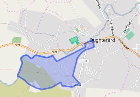
Maps
It is located at 53° 25′ 23″ N, 9° 20′ 11″ W.
Original OS map of this area. Ireland was first mapped in the 1840s. These original maps are available online.
Original OS maps at the Ordnance Survey of Ireland website.
Below is a link to the Ordnance Survey of Ireland website. It displays the original OS map that was created in the 1840s.
Information from Google Maps. You can use this link to find this townland on Google Maps.
Information from the National Monuments Service.
You can use this link to view a map of archaeological features. This link brings you to a website wherein you will have to search for your townland.
Archaeological map from the National Monuments Service
Galway Library Website
http://places.galwaylibrary.ie/place/52504
Townlands.ie Website
https://www.townlands.ie/galway/moycullen/kilcummin/oughterard/canrawer-west/


No Comments
Add a comment about this page