Canrawer East
Text - Treasa NicDhonncha & Hyperlinks - Antoinette Lydon


Canrawer East (changed from Kanrawer) is in the civil parish of Kilcummin. The civil parish corresponds with the following Church of Ireland parish of Kilcummin, Galway West. In general, the civil parish and the Church of Ireland parish are the same as is the case in the Kilcummin Oughterard area.
Irish Form of Name: Ceann Ramhar
Translation: thick head
Canrawer East is in the Electoral Division of Oughterard, in Civil Parish of Kilcummin, in the Barony of Moycullen, in the County of Galway
O’Donovan’s Field Name Books
Other Forms of the Name:
Canrawer [changed from Kanrawer]
Ceann Ramhar Cean Ramhar
Kanrawer East Boundary Surveyor
Canrawer Barony Cess Book
Canrower County Map
Canrawer or fat head Local
North East Canerour Rector of Kilcummin
Canrower Barony Map
Comment:
Compare and make all the Cans agree
Description:
Present Proprietor Captain O’Flaherty, Canrauer East is part of the townland of Billimore or Millimore, a herd lives in it to herd for the village. Contains 15 acres all under plantation. There is a Roman Catholic Chapel together with the residence of the Rev. P. W. Kirwan, P.P., both situated in the eastern part of the townland.
Situation:
In the Northern extremity of the parish. Bounded on the N. by Carhoomaanagh, on the N.W. by Clare and Clare Mount, on the S. E. by Kanrauwer W., and on the S.W. by Kanrauwer.
This is a list of townlands that share a border with this townland.
Some other placenames in or near this townland are…
- Cushmeagnacally (rock)
Proprietor: Captain O’Flaherty of Lemonfield
O’Flaherty is a member of the O’Flahertie (Lemonfield) family.
Landed Estates Database:
The O’Flahertie’s of Lemonfield are descended from the O’Flahertie’s of Aughnanure Castle near Oughterard, county Galway. Their estate was in the parish of Kilcummin, barony of Moycullen, county Galway, and Lemonfield, close to the village of Oughterard, was their seat from the mid18th century. There are some 17th and 19th century records relating to them in the Westport Papers. The O’Flahertie estate of over 4500 acres was advertised for sale in 1854 and a reduced acreage of 2346 acres in 1864. Both rentals included lead mines and a black marble quarry. The Irish Times reports that the 1864 sale saw many of the lots bought by a Mr. Carpenter. In the 1870s the O’Flahertie’s owned 2340 acres in county Galway. By March 1916 they had accepted offers from the Congested Districts’ Board for parts of their estate.
The Tithe Applotment Books
About the Records
Tithes were a tax on agricultural produce which was payable by the occupiers of agricultural land. They were the main source of income for the parish clergy of the Church of Ireland (the largest Protestant church and the church established by law). However, in many parishes a large part of the tithes was ‘appropriate’, which meant that they were payable to a bishop, cathedral chapter or other ecclesiastical recipient, or were ‘impropriate’, which generally meant that they were payable to a local landowner. The parishes used in the Tithe Applotment Books are civil or Church of Ireland parishes, which often differ in name and territory from Catholic parishes,
Acts of Parliament of 1823 and 1832 provided for the conversion of tithes into a fixed charge on land, and specified the average price of wheat or oats in the parish in the seven years before 1821 as the basis on which the tithes would be calculated. They also extended the application of tithes to pasture, where previously they had been levied only on tillage.
This change in the law resulted in the valuation of individual holdings in almost all parishes containing agricultural land, in order to assess the portion of the tithes for which each occupier of land would be liable. The apportionment was recorded for each Church of Ireland parish in a Tithe Composition Applotment Book. The information was collected and the amounts were calculated by two Parochial Commissioners, one of whom was appointed by the cess-payers of the parish and the other by the relevant Diocese of the Church of Ireland. This procedure was carried out in over 2,500 parishes between the years 1823 and 1837.
The Tithe Applotment Books are in a variety of formats, from a few pages sewn together to elaborately bound volumes. In most cases they are written in manuscript throughout, although some consist of manuscript entries on printed questionnaires. The information in the books is broadly uniform and generally includes at least the name of occupier; the size of holding, the valuation and the tithe payable. In some cases, more detailed information is provided. Some volumes have maps and most have certificates and correspondence attached.
The sub-divisions of the parish were recorded. Some of these subdivisions, such as ploughlands, ceased to be in official use after the six-inch survey of the Ordnance Survey was completed in the 1840s. Only productive land was subject to tithe, and the books usually distinguish between this tithable land and untithable land such as roads or mountains. Tithable land was in some cases classified by quality, and a money value was given to each class. In some cases, the proportion of tithe payable to the rector, vicar or lay proprietor of the tithes was set out. The column for observations was sometimes completed, with information about commonage, for example.
There are a number of other points that should be noted. The acreages given in the Tithe Applotment Books are in Irish or Plantation measure, which is 1.62 times larger than statute measure. Only occupiers of land at the time of the tithe composition are recorded, so not all heads of households living in a parish at the time are included. Only rural areas are systematically covered, although inhabitants of towns who held plots of cultivable land are included. The equivalent tax in urban areas, Minister’s Money, has left few records.
The Tithe Applotment Books are an important source of information for a wide variety of researchers of pre-Famine Ireland. They provide the first surviving national list of the occupiers of land, and are used by genealogists as a partial substitute for returns of the 1821 and 1831 censuses of population, which were destroyed in 1922. They also record information on the quality of land, and provide information on pre-Ordnance Survey territorial divisions, some of which were not recognised after the 1840s.
The National Archives hold the original Tithe Applotment Books only for the twenty-six counties of the Republic of Ireland. The books for the six counties of Northern Ireland are held in the Public Record Office of Northern Ireland in Belfast. (http://titheapplotmentbooks.nationalarchives.ie/search/tab/aboutmore.jsp)
Tithe Applotment Record for Canrawer East
Landholders
Listed in the Tithe Applotment book for Canrawer East in 1829 on James Lambert Esq’s estate were; John McDonagh, Martin Lydon, Martin Donahoe, John Donahoe, John Landy,
Land Liable for Tithe
The total land liable for tithes in Canrawer East was 15 acres. This was broken up into five separate columns according to the quality of land. In Canrawer East the 4th and 5th rate quality land was left blank.
o 5 acres of 1st rate quality land with a tithe of 1s 6d per acre.
o 5 acres of 2nd rate quality land with a tithe of 1s per acre.
o 5 acres of 3rd rate quality land with a tithe of 3d per acre.
Tithes Payable
The proportion of tithes payable to Richard Martin Esq. was 6s 10 1/2d, the proportion of tithes payable to Reverend James Daly was 3s 5 1/4d, and the proportion of tithes payable to Reverend John Wilson was 3s 5 1/4d.
Information from Down Survey
The Down Survey is a mapped survey. Using the Civil Survey as a guide, teams of surveyors, mainly former soldiers, were sent out under Petty’s direction to measure every townland to be forfeited to soldiers and adventurers. The resulting maps, made at a scale of 40 perches to one inch (the modern equivalent of 1: 50,000), were the first systematic mapping of a large area on such a scale attempted anywhere. The primary purpose of these maps was to record the boundaries of each townland and to calculate their areas with great precision. The maps are also rich in other detail showing churches, roads, rivers, castles, houses and fortifications. Most towns are represented pictorially and the cartouches, the decorative titles, of each map in many cases reflect a specific characteristic of each barony. (http://downsurvey.tcd.ie)
Townland of CANRAWER EAST
Down Survey Name: Canrowre
1641 Owner(s): Clanrickard, Earl of (Protestant)
1670 Owner(s): Clanrickard, Earl of (Protestant)
County: Galway Barony: Muckullin
Parish: Killcumyn
The down survey website will tell you who owned this townland in 1641 (pre Cromwell) and in 1671 (post Cromwell).
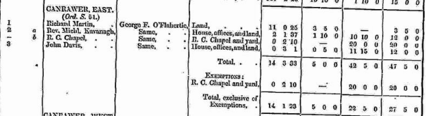
Griffith’s Valuation 1850s
In Griffith’s Valuation the area prior to exemptions was 14 acres 3 roods and 33 perches with a land value of £5 and a building value of £42 5s 0d with a total value of £47 5s 0 d. The R.C. Chapel was exempt and consisted of 2 roods 10 perches with a building value of £20. After that was deducted the total area was 14 acres 1 roods and 23 perches with a land value remaining at £5 and a total building value of £22 5s 0d with a total value of £27 5s 0d.
Occupiers of the Land:
The occupiers of the land at this time were: Richard Martin, Rev. Michl. Kavanagh, John Davis and an R.C. Chapel.
The Landlord or immediate leasers was George F. Flahertie
Ownership of Land and Property
Richard Martin owned 11 acres 0 roods and 25 perches of land, Rev. Michl Kavanagh owned a house, 2 acres 1 rood and 37 perches of land and offices, John Davis owned a house, 3 roods and 1 perch of land and offices, the RC. Chapel consisted of a Chapel and a yard with an area of 2 roods and 10 perches.
Annual Valuation
The total annual valuation of rateable property after exemptions were deducted in Canrawer came to £27 5s 0d.
Land Rates: Richard Martin paid £3 5s 0d, Rev. Michl Kavanagh paid £1 10s 0d and John Davis paid £0 5s 0d
Building Rates: Michl Kavanagh paid £10 10s 0d, John Davis paid £11, 15s 0d and the R.C. Chapel was valued at £20 but was exempt.
View the heads of households in the townland at this time.
http://www.askaboutireland.ie/griffith-valuation/index.xml?action=doNameSearch&PlaceID=559668
Out Offices and Land
The out office was a farm building, a cow house, piggery or barn. The land was very poor and sterile and people were always poverty-stricken. At this time most tenants were trying to eke out a living on 5 acres or less and farmers needed at least 15.3 acres to survive.
Poor Law Union Ireland
In Ireland the Poor Relief Act of 1838 divided into districts or “unions” in which the local taxable inhabitants were to be financially responsible for all paupers in the area. In 1898 the Poor Law Union was adopted as the basic administrative division in place of the civil parish and barony. Further subdivision into 828 registration districts and 3,751 district electoral divisions followed. Townlands were not arranged according to these divisions with parish and barony retained as a means to make comparisons with records gathered before 1898.
The 1838 Act
The main provisions of the 1838 Act were:
o The extension of the existing Poor Law Commissioners’ powers to Ireland, with the appointment of Assistant Commissioners who were to implement the Act in Ireland.
o The division of the country into Poor Law Unions based on Irish electoral divisions which were themselves made up from townlands.
o The creation of a Board of Guardians for each Union, two-thirds of whom were to be elected, the other third to be appointed ex officio.
o The setting up of a workhouse in each Union.
o The collection of a local poor-rate to finance the system.
o Assistance for emigration.
Initially, 130 Unions were created, based upon 2,049 electoral divisions. The divisions were composed of townlands, a peculiarly Irish unit, traditionally of 120 Irish acres in area. (Between 1848 and 1850, an additional 33 Unions were created by subdividing and reorganizing the boundaries of some existing Unions, particularly in the west of the country.
Boards of Guardians were elected annually on 25th March. Only rate-payers were eligible for election, which effectively disenfranchised most of the native Irish who were usually tenants at this time. Rate-payers were allowed between one and six votes depending on the size of a valuation of their property.
Townlands
A town land is one of the smallest land divisions in Ireland. They range in size from a few acres to thousands of acres. Many are Gaelic in origin, but some came into existence after the Norman invasion 1169. Canrawer East is a townland.
1841-1891 Census
1841 – 1 house with 4 people
1851-1891 – Nothing listed as the townland was included in the Census for the town of Oughterard.
1901 Census
This is a return of the members of the family, their Visitors, Boarders, Servants who slept or abode in their house on the night of Sunday March 31st 1901 in Canrawer East.
General Information
There were 12 buildings listed in the townland of Canrawer. 9 of the houses were inhabited. Building no. 1 was a public house, building no.3 was a shop, building no. 4 was a private dwelling but uninhabited, building no. 9 was a R.C. Convent, building no. 10 was an Industrial School, building no. 11 was a Convent National School, building no. 12 was a R.C. Chapel.
http://www.census.nationalarchives.ie/reels/nai000841049/
Farm Buildings and Out Offices
There were 21 out offices and farm steadings in the townland. These were; Stables, coach houses, cow houses, a dairy, piggeries, fowl houses, barns, a turf house, a workshop and a shed.
http://www.census.nationalarchives.ie/reels/nai000841050/
Description of the Houses
Class of House: The class of house depended on the materials used in the roof, walls, number of rooms and number of front windows. A 1st class house was considered the highest standard.
Walls of the houses: The walls were of stone, brick, and concrete or of mud, wood or other perishable material. The houses in Canrawer were built of stone, brick or concrete. There were no mud cabins.
Roofs: Roofs were of slate, iron, tiles, thatch, wood or other perishable material. 3 of the buildings had roofs of thatch, wood or perishable material. They were most likely thatched. The other buildings were of slate, iron or tile.
House Occupancy
6 of the 12 buildings were listed as private dwellings and were occupied by 1 family. House no. 1 was listed as a public house and was occupied by 1 family. House no. 3 was a shop and was occupied by 1 family. House no. 4 was uninhabited. House no. 9 was listed as a R.C. Convent and was inhabited by 1 family. Building no. 10 was listed as an Industrial School and was inhabited by 1 family. Building no.11 was a Convent National School and building no. 12 was a R.C. Chapel, both were uninhabited. The people listed as the head of the family was also listed as the lawful landholder with the exception of house No. 6 (see below). There was a total population of 80, with 12 males and 68 females residing in the townland. Everyone was Roman Catholic. Not everyone was born in Co Galway.
http://www.census.nationalarchives.ie/reels/nai000841048/
House No. 1 (5 occupants) Public House
Thomas Fahy Naughton aged 64 was the head of the family. He lived with his wife Eleanor aged 46. Thomas was a hotel keeper and C and C. He had 4 out buildings, 1 stable, 1 cow house, 1 fowl house and 1 turf house. His daughter Sarah Ellen Naughton aged 27 also lived in the house. Sarah was a house manageress and was born in Co Monaghan. She was not married. Also living in the house was James Phillips aged 22 and Mary Faherty aged 20. James was a messenger servant and Mary was a domestic servant. They were both unmarried. Everyone in the house could read and write and they all spoke Irish and English. They lived in a class 1 house with 7 front windows. 5 people occupied 17 available rooms.
http://www.census.nationalarchives.ie/pages/1901/Galway/Oughterard/Carrower_East/1394792/
House No. 2 (3 occupants)
Michael Walsh aged 39 was the head of the family. He was a carpenter and had 6 out buildings, 2 cow houses, 1 piggery, 1 fowl house, 1 work shop and 1 shed. Michael was not married and lived with his brother John aged 36 and his sister Mary aged 30. John was a farmer and Mary was a house keeper. They were both unmarried. Everyone could read and write and they all spoke Irish and English. They lived in a class 2 house with 5 front windows. 3 people occupied 6 available rooms.
http://www.census.nationalarchives.ie/pages/1901/Galway/Oughterard/Carrower_East/1394793/
House No. 3 (4 occupants) Shop
Michael Walsh aged 60 was the head of the family. He lived with his wife Bridget aged 50. Michael was a shop keeper and had 2 out buildings, 1 piggery and 1 barn. Also living in the house were his son Laurence J aged 17 who was an assistant shop keeper and his mother in law Bridget McDonagh aged 82. Bridget had no occupation and was a widow. Michael could read, his wife and son could read and write and his mother in law could not read. They all spoke Irish and English. They lived in a class 2 house with 3 front windows. 4 people occupied 2 available rooms.
http://www.census.nationalarchives.ie/pages/1901/Galway/Oughterard/Carrower_East/1394794/
House No. 4 (0 occupants)
David O’Dowd was the legal landholder of the property. The house was uninhabited.
House No. 5 (6 occupants)
Michael Walsh aged 40 was the head of the family. He lived with his wife Mary Anne aged 36. Mary Anne was born in Co Dublin. Michael was a tailor and Mary Anne was a teacher. He had no out buildings. Also living in the house were his sons Patrick aged 17, Timothy aged 15 and Michael aged 13 and his daughter Carmella aged 11. Patrick and Timothy were tailors. Michael and Carmella were attending school. Everyone could read and write and they all spoke Irish and English. They lived in a class 3 house with 2 front windows, 6 people occupied 2 available rooms.
Timothy Walsh Connaught Rangers Died: Friday 21 January 1916 aged 32 Iraq
http://www.census.nationalarchives.ie/pages/1901/Galway/Oughterard/Carrower_East/1394795/
House No. 6 (3 occupants)
Anne Coneely aged 82 was the head of the family.She had no profession or occupation. She had no out buildings. Anne was a widow and lived with her daughter Bridget aged 56 and her granddaughter Anne O’Brien aged 20. Bridget was not married and had no profession or occupation. Bridget was blind. Anne was unmarried and was a house keeper. Neither Anne nor Bridget could read, Anne O’Brien could read and write. They all spoke Irish and English. They lived in a class 3 house with 1 front window. 3 people occupied 2 available rooms. Bridget Coneely was listed as the legal land holder and head of the family on the House and Building Return Form.
http://www.census.nationalarchives.ie/pages/1901/Galway/Oughterard/Carrower_East/1394796/
House No. 7 (1 occupant)
Kate Clancy aged 60 was the head of the house. Kate was a widow and lived alone. She was a general domestic servant and had no out buildings. Kate could not read and spoke Irish and English. She lived in a class 2 house with 2 front windows. 1 person occupied 2 available rooms. Redmond McDonagh was the legal land holder of the property.
http://www.census.nationalarchives.ie/pages/1901/Galway/Oughterard/Carrower_East/1394797/
House No. 8 (3 occupants)
Redmond McDonagh aged 60 was the head of the family. Redmond was the Parish Priest. He had 6 out buildings, 1 stable, 2 coach houses, 1 cow house, 1 piggery and 1 barn. He lived with John Keeley aged 45 who was the curate and Catherine Conneely aged 50 who was a servant. Redmond and John could read and write, Catherine could read. They all spoke Irish and English. They lived in a class 2 house with 5 front windows. 3 people occupied 9 available rooms.
http://www.census.nationalarchives.ie/pages/1901/Galway/Oughterard/Carrower_East/1394798/
House No. 9 (15 occupants) Roman Catholic Convent
Mary Clader aged 61 was the head of the family. Mary was a Sister of Mercy and lived with other sisters, Aloysia Hogan aged 70, Mary Buchanan aged 52 who was born in Dublin, Mary Patrick aged 50 who was born in Co Mayo, Mary Catherine aged 48 who was born in Birr, Mary Bridget aged 41, Mary Attracta aged 30 who was born in Birr, Mary Brendan aged 29 who was born in Headford and Mary Rowland aged 23 who was born in Turen. Also living in the house were general servants, Norah Dillon aged 26 and Ellen Butler aged 54, seamstress Dora Grogan aged 48 who was born in Queen’s County, domestic Sabina Sullivan aged 24 and scholars Honor Gill aged 15 and Mary Connor aged 15. Sabina Sullivan was listed as deaf and dumb. Everyone could read and write and they all, apart from Sabina, spoke English. Mary Rowland spoke Irish and English. They had no out buildings. They lived in a class 1 house with 16 front windows. 15 people occupied 17 available rooms.
http://www.census.nationalarchives.ie/pages/1901/Galway/Oughterard/Carrower_East/1394799/
House No. 10 (40 occupants) Industrial School
Mary Clader was listed as the head of the family and legal land holder of the property on the House and Building Return Form. There were 40 girls living in the industrial school. The eldest was 17 and the youngest was 6. They were Kate Moran aged 13, Ann Couroy aged 13, Maria McDonagh aged 11, Barbar Nee aged 9, Ann Dowens aged 9, Bridget Hynes aged 11, Mary Walsh aged 10, Kate Folan aged 10, Mary Duanny aged 14, Chrissie Delaney aged 13, Mary Welby aged 14, Rose Burges aged 11, Bridget Connor aged 7, Barbara Welby aged 8, Kate Rowland aged 9, Mary Connor aged 9, Bridget Connor aged 14, Maria Henderson aged 14, Norah Collins aged 15, Mary Hickey aged 15, Mary Newell aged 14, Alice Newell aged 11, Jessie Graham aged 13, Anne Connolly aged 13, Maggie Finegan aged 13, Sarah Coyne aged 12, Lizzie Coyne aged 10, Mary E Faherty aged 11, Bridget Newell aged 9, Mary Moran aged 14, Alice Rowland aged 10, Ellen Rally aged 9, Bridget O’Donnell aged 10, Agnes O’Donnell aged 11, Bridget Barrett aged 11, Kate Barrett aged 10, Mary Walsh aged 9, Mary A O’Donnell aged 17, Sabina Fully aged 11, and Katie Welley aged 6. Everyone could read and write apart from the youngest, Katie Welley who could read only. Thy all spoke English. They lived in a class 1 house with 18 front windows. 40 people occupied 10 available rooms.
http://www.census.nationalarchives.ie/pages/1901/Galway/Oughterard/Carrower_East/1394800/
House No. 11 (0 occupants) Convent National School
Mary Clader was the legal landholder.
House No. 12 (0 occupants) Roman Catholic Chapel
Redmond McDonagh was the legal landholder.
1911 Census
This is a return of the Members of families in Canrawer East, their visitors, boarders and servants who slept or abode in the house on the night of Sunday the 2nd of April 1911.
Description of the Houses: All the houses in Canrawer East were listed as private dwellings and were built of concrete or stone. All of the houses had roofs of slate, iron or tile, probably slate. The heads of the families were listed as the landholders except house no. 3 (see below). One family lived in each property. House no. 1 was a Convent School. The Class of the house depended on the material used in the roof, walls, number of rooms and number of front windows. Most of the houses came under “2’ in the census form meaning that there could be 2, 3, or 4, rooms in the house. One house came under ‘1’ which meant there was 1 room in the house.
Enumerators Extract
http://www.census.nationalarchives.ie/reels/nai002436211/
http://www.census.nationalarchives.ie/reels/nai002436212/
House & Building Return
http://www.census.nationalarchives.ie/reels/nai002436213/
Out Office & Farm Steadings
http://www.census.nationalarchives.ie/reels/nai002436215/
General Information
3 of the 4 buildings were listed as private dwellings and all of the houses were occupied by 1 family. They were all Roman Catholics and the head of the family was the landholder except house no. 3. There were a total of 24 people living in the village, 9 males and 15 females. Building no. 1 was a Convent School. There were a total of 7 farm buildings in the village. These were 2 stables, 3 cow houses, 1 barn and 1 shed.
House No. 1 (11 occupants) Convent School
M Clare Harty aged 50 was the head of the family. She was born in Co Tipperary and was a Sister of Mercy. Also living in the house were other members of the community, M Augustine Heslan aged 40 born in Co Clare, M Gongaga Molloy aged 30 born in Co Mayo, M Clan Shepine aged 26 born in Co Clare, M Agnes Sweeney born in Co Tipperary, M Angelea Walsh aged 24 born in Co Mayo and M Vincent Sharkey aged 35 born in Co Roscomon. Also living in the house were general servants Mary Healy aged 19, Agnee Hagan aged 14 born in Co Dublin and Margaret Glynn aged 21. Cecelia Patterson aged 86 was a border in the house. She was born in Co Dublin. Everyone could read and write. Everyone spoke Irish and English. This information is not given for M Clare Harty, M Augustine Heslan, Agnee Hagan and Cecelia Patterson. They lived in a class 1 house with 12 front windows. 11 people occupied 9 available rooms. They had a cow house, a barn and a shed.
http://www.census.nationalarchives.ie/pages/1911/Galway/Oughterard/Canrawer_East__Main_St_/471423/
House No. 2 (2 occupants)
Redmond McDonagh aged 71 was the head of the family. He was the Parish Priest and lived with Harry Geale aged 21 who was a general servant and single. They had a stable and a cow house. They could both read and write and they both spoke Irish and English. They lived in a class 2 house with 4 front windows. 2 people occupied 7 available rooms.
http://www.census.nationalarchives.ie/pages/1911/Galway/Oughterard/Canrawer_East__Main_St_/471424/
House No. 3 (1 occupant)
Catherine Clancy aged 73 was the head of the family. Catherine’s occupation was listed as ‘in charge of the church’. She was married for 50 years and had 1 child born alive and 1 child still living. She lived alone and had no out buildings. she could not read and spoke Irish. She lived in a class 3 house with 1 front window. 1 person occupied 1 available room. Rev. Redmond McDonagh was the legal landholder of the property.
http://www.census.nationalarchives.ie/pages/1911/Galway/Oughterard/Canrawer_East__Main_St_/471425/
House No. 4 (10 occupants)
Peter Henry Joyce aged 43 was the head of the family. He was a Clerk of Union tc. He had a stable and a cow house. Peter lived with his wife Cecilia Mary aged 36. They were married for 14 years and had 7 children born alive and 7 children still living. Also living in the house were his daughter Olive Margh Mary aged 13 and his sons Arthur deBurgh aged 12, John Patrick aged 11, Leo Henry Michael aged 10, Frederick Noel aged 7, Alfred Thomas Joseph aged 4 and Edward Cecil aged 1. All the children apart from the 2 youngest were scholars. Elizabeth Mulley aged 17 also lived in the house. She was a general servant domestic. Everyone except the 2 youngest children could read and write. They all spoke Irish and English except for Cecilia Mary and her 2 youngest children, this information was not given for them. They lived in a class 2 house with 5 front windows. 10 people occupied 5 available rooms.
http://www.census.nationalarchives.ie/pages/1911/Galway/Oughterard/Canrawer_East__Main_St_/471426/
Church records of births, deaths and marriages:
Church records of births, deaths and marriages are available online at http://www.rootsireland.ie. To search these records, you will need to know the ‘church parish’ rather than the ‘civil parish’. (The civil parish is the pre-reformation parish and was frequently used as a unit of administration in the past.)
Canrawer East is in the civil parish of Kilcummin.
Roman Catholic parishes:
This civil parish corresponds with the following Roman Catholic parish or parishes.
- Carraroe
- Kilannin
- Kilcummin/Oughterard
- Rosmuc
Church of Ireland parishes:
This civil parish corresponds with the following Church of Ireland parish.
- Kilcummin
In general, the civil parish and the Church of Ireland parish are the same, but, this is not always the case.
Maps
It is located at 53° 25′ 33″ N, 9° 19′ 55″ W.
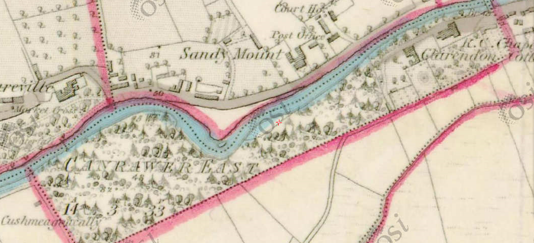
Original OS map of this area. Ireland was first mapped in the 1840s. These original maps are available online.
Canrawer [changed from Kanrawer]
Original OS maps at the Ordnance Survey of Ireland website.
Below is a link to the Ordnance Survey of Ireland website. It displays the original OS map that was created in the 1840s.
Canrawer [changed from Kanrawer]
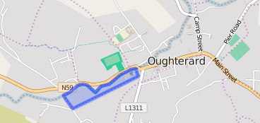
Information from Google Maps.
You can use this link to find this townland on Google Maps
Information from the National Monuments Service.
You can use this link to view a map of archaeological features. This link brings you to a website wherein you will have to search for your townland.
Archaeological map from the National Monuments Service
Galway Library Website
http://places.galwaylibrary.ie/place/52491
Townlands.ie Website
https://www.townlands.ie/galway/moycullen/kilcummin/oughterard/canrawer-east/


No Comments
Add a comment about this page