Ard
David Collins & Antoinette Lydon

Ard is in the civil parish of Kilcummin. The civil Parish corresponds with the following Church of Ireland parish of Kilcummin, Galway West. In general the civil parish and the Church of Ireland parish are the same as is the case in the Kilcummin Oughterard area.
Ard is in the Electoral Division of Oughterard, in Civil Parish of Kilcummin, in the Barony of Moycullen, in the County of Galway
Standard Name: Ard
Irish Form of Name: Árd
Translation: a height or hill
Parish:
Kilcummin
View all place names in this civil parish.
Other Forms of the Name with the authority source (if provided) in italics.
Ard
Árd
Ard Boundary Surveyor
Ard Barony Cess Book
Ard County Map
Ard Local
Ard Rector of Kilcummin
Ard Barony Map
Other placenames in this townland:
Some other place names in or near this townland are …
- Baurnahardia (point)
- Eagle Island No. 1 (rock)
- Eagle Island No. 2 (rock)
- Eagle Island No. 3 (rock)
- Grass Bush I. (island)
- Illaunnagapple (trigonometrical station)
- Moor Island No. 1 (rock)
Ard is situated in the northern extremity of the parish. Bounded on the N.E. and W. by Lough Corrib and S. by Ardnasillagh townland.
A list of townlands that share a border with this townland:
This is a list of townlands that share a border with this townland.
Information from Joyce’s Place Names
Translation according to P. W. Joyce
Ard, a height (or as an adjective high), entering so frequently into Irish names, has been already discussed in vol. i. p. 385 [reproduced below]. Other combinations will be examined here.
Ard is sometimes a noun meaning a height or hill, and sometimes an adjective, signifying high: cognate with Lat. Arduus. In both senses it enters extensively into Irish nomenclature; it forms the beginning of about 650 townland names; and there are at least as many more that contain it otherwise combined. There is a little town in Waterford, and about twenty-six townlands in different counties, called Ardmore, great height; but only two bear the correlative name, Ardbeg, little height. Ardglass in Down is called Ard-glas by the Four Masters, i.e. green height; which is also a usual townland name; and there are many places scattered over the country, called Ardkeen, that is, Ard-caein, beautiful height. Arderin in the Queen’s County is the highest of the Slieve Bloom range; and the inhabitants of the great central plain who gave it the name, signifying the height of Ireland, unaccustomes as they were to the view of high mountains, evidently believed it to be one of the principal elevations in the country. When ard is followed by tighe [tee], a house the final d is usually omitted; as in Artiferrall in Antrim, Ard-tighe-Fearghaill, the height of Farrell’s house; Artimacormick near Ballintoy, same county, the height of Mac Cormack’s house, etc. This word has two diminutives, airdin and ardán [ardeen, ardaun]; the former is not much in use, but it gives name to some places in Cork and Kerry, called Ardeen, and it forms a part of a few other names. The latter, under the different forms Ardan, Ardane, and Ardaun, all meaning little height or hillock, is by itself the name of several places in the midland counties; and it helps to form many others, such as Ardanreagh in Limerick, grey hillock; and Killinardan near Tallaght in Dublin, the church or wood of the little height.
Landlord
Proprietor: Arthur FFrench Esq. of Tyrone house
French (Tyrone) – Jeffrey French was granted various lands in counties Mayo, Galway, Roscommon and Clare by patent dated 10 Aug 1678. His brother Arthur French of Tyrone, county Galway, Mayor of Galway 1691, had 2 sons Christopher from whom descend the French/St George family of Tyrone and Arthur ancestor of the French family of Cloonyquin, parish of Elphin, barony of Roscommon, county Roscommon. Patrick French of Brook Lodge, parish of Killererin, barony of Clare, county Galway, was a younger son of Christopher of Tyrone. Burke writes that Arthur French, Christopher’s heir was involved in a case in the House of Lords 1764-1765 French v Caddell. In 1736 he married Olivia Usher sister of St George Usher St George of Headford, county Galway, created Baron St George of Hatley St George. Their son Christopher assumed the surname St George in 1774 in compliance with his great grandfather’s will.
Information from the Down Survey Website:
The Down Survey website will tell you who owned this townland in 1641 (pre Cromwell) and in 1671 (post Cromwell).
Townland of Ard
Down Survey Name: Mountain
1670 Owner(s): Martin, Richard (Catholic); Clanrickard, Earl of (Protestant)
County: Galway
Barony: Muckullin
Parish: Killcumyn
http://downsurvey.tcd.ie/landowners.php#mc=53.43079,-9.24355&z=14
The Tithe Applotment Books:
About the Records
Tithes were a tax on agricultural produce which was payable by the occupiers of agricultural land. They were the main source of income for the parish clergy of the Church of Ireland (the largest Protestant church and the church established by law). However, in many parishes a large part of the tithes were ‘appropriate’, which meant that they were payable to a bishop, cathedral chapter or other ecclesiastical recipient, or were ‘impropriate’, which generally meant that they were payable to a local landowner. The parishes used in the Tithe Applotment Books are civil or Church of Ireland parishes, which often differ in name and territory from Catholic parishes, Acts of Parliament of 1823 and 1832 provided for the conversion of tithes into a fixed charge on land, and specified the average price of wheat or oats in the parish in the seven years before 1821 as the basis on which the tithes would be calculated. They also extended the application of tithes to pasture, where previously they had been levied only on tillage.
This change in the law resulted in the valuation of individual holdings in almost all parishes containing agricultural land, in order to assess the portion of the tithes for which each occupier of land would be liable. The apportionment was recorded for each Church of Ireland parish in a Tithe Composition Applotment Book. The information was collected and the amounts were calculated by two Parochial Commissioners, one of whom was appointed by the cess-payers of the parish and the other by the relevant Diocese of the Church of Ireland. This procedure was carried out in over 2,500 parishes between the years 1823 and 1837.
The Tithe Applotment Books are in a variety of formats, from a few pages sewn together to elaborately bound volumes. In most cases they are written in manuscript throughout, although some consist of manuscript entries on printed questionnaires. The information in the books is broadly uniform and generally includes at least the name of occupier; the size of holding, the valuation and the tithe payable. In some cases more detailed information is provided. Some volumes have maps and most have certificates and correspondence attached.
The sub-divisions of the parish were recorded. Some of these subdivisions, such as ploughlands, ceased to be in official use after the six inch survey of the Ordnance Survey was completed in the 1840s. Only productive land was subject to tithe, and the books usually distinguish between this tithable land and untithable land such as roads or mountains. Tithable land was in some cases classified by quality, and a money value was given to each class. In some cases the proportion of tithe payable to the rector, vicar or lay proprietor of the tithes was set out. The column for observations was sometimes completed, with information about commonage, for example.
There are a number of other points that should be noted. The acreages given in the Tithe Applotment Books are in Irish or Plantation measure, which is 1.62 times larger than statute measure. Only occupiers of land at the time of the tithe composition are recorded, so not all heads of households living in a parish at the time are included. Only rural areas are systematically covered, although inhabitants of towns who held plots of cultivable land are included. The equivalent tax in urban areas, Minister’s Money, has left few records.
The Tithe Applotment Books are an important source of information for a wide variety of researchers of pre-Famine Ireland. They provide the first surviving national list of the occupiers of land, and are used by genealogists as a partial substitute for returns of the 1821 and 1831 censuses of population, which were destroyed in 1922. They also record information on the quality of land, and provide information on pre-Ordnance Survey territorial divisions, some of which were not recognised after the 1840s.
The National Archives hold the original Tithe Applotment Books only for the twenty-six counties of the Republic of Ireland. The books for the six counties of Northern Ireland are held in the Public Record Office of Northern Ireland in Belfast. (http://titheapplotmentbooks.nationalarchives.ie/search/tab/aboutmore.jsp)
Tithe Applotment – Ard
John Conneely, Michl Derrane, Martin McDonagh & Laurence Tollan had a total of 20 acres of land in Ard; 5 acres of 1st quality with a payment of 1s 6d, 5 acres of 2nd quality with a payment of 1s, 10 acres of 5th quality with a payment of ⅛d.
The Tithes payments went to Richard Martin Esq. the Reverend James Daly & the Reverend John Wilson.
Down Survey
The Down Survey is a mapped survey. Using the Civil Survey as a guide, teams of surveyors, mainly former soldiers, were sent out under Petty’s direction to measure every townland to be forfeited to soldiers and adventurers. The resulting maps, made at a scale of 40 perches to one inch (the modern equivalent of 1:50,000), were the first systematic mapping of a large area on such a scale attempted anywhere. The primary purpose of these maps was to record the boundaries of each townland and to calculate their areas with great precision. The maps are also rich in other detail showing churches, roads, rivers, castles, houses and fortifications. Most towns are represented pictorially and the cartouches, the decorative titles, of each map in many cases reflect a specific characteristic of each barony. http://downsurvey.tcd.ie/
Townland of ARD
Down Survey Name: Mountain
1670 Owner(s): Martin, Richard (Catholic); Clanrickard, Earl of (Protestant)
County: Galway
Barony: Muckullin
Parish: Killcumyn
Information from the Down Survey Website:
The Down Survey website will tell you who owned this townland in 1641 (pre Cromwell) and in 1671 (post Cromwell).
Information from Griffith’s Valuation 1855:
All the land is recorded as being leased by John Doig ‘In Fee’, meaning that the occupier is also the legal owner of the property. He occupied a House, offices and land 106 A 0R 29P with an annual rateable value of £28. 15s.
There are three parcels of land recorded and three tenants:
John Doig. House. Offices and land
Richard Thomas. House and land. £16
Peter McDonagh House £0. 10s.
Census 1881:
Area. 106 Acres. 0 Rood. 29 Perch.
View the heads of households in the townland at this time;
Out Offices and Land
The out office was a farm building, a cow house, piggery or barn. The land was very poor and sterile and people were always poverty-stricken. At this time most tenants were trying to eke out a living on 5acres or less and a farmer needed at least 15.3 acres to survive.
Poor Law Union Ireland
In Ireland the Poor Relief Act of 1838 divided into districts or “unions” in which the local taxable inhabitants were to be financially responsible for all paupers in the area. In 1898 the Poor Law Union was adopted as the basic administrative division in place of the civil parish and barony. Further subdivision into 828 registration districts and 3,751 district electoral divisions followed. Townlands were not arranged according to these divisions with parish and barony retained as a means to make comparisons with records gathered before 1898.
The 1838 Act
The main provisions of the 1838 Act were:
- The extension of the existing Poor Law Commissioners’ powers to Ireland, with the appointment of Assistant Commissioners who were to implement the Act in Ireland.
- The division of the country into Poor Law Unions based on Irish electoral divisions which were themselves made up from townlands.
- The creation of a Board of Guardians for each Union, two-thirds of whom were to be elected, the other third to be appointed ex officio.
- The setting up of a workhouse in each Union.
- The collection of a local poor-rate to finance the system.
- Assistance for emigration.
Initially, 130 Unions were created, based upon 2,049 electoral divisions. The divisions were composed of townlands, a peculiarly Irish unit, traditionally of 120 Irish acres in area. (Between 1848 and 1850, an additional 33 Unions were created by subdividing and reorganizing the boundaries of some existing Unions, particularly in the west of the country.
Boards of Guardians were elected annually on 25th March. Only rate-payers were eligible for election, which effectively disenfranchised most of the native Irish who were usually tenants at this time. Rate-payers were allowed between one and six votes depending on the size of a valuation of their property.
Population and Census Information
You can retrieve a list of people who lived in this townland from 1827 to 1911. This list is compiled from the following resources.
- The Tithe Applotment Books
- Griffith’s Valuation
- 1901 Census
- 1911 Census
List of nineteenth century and early twentieth century inhabitants.
Census 1841-1891:
1841 – 12 houses with 63 persons
1851 – 4 houses with 39 persons
1861 – 2 houses with 10 persons
1871 – 1 house with 12 persons
1881 – 1 house with 4 persons (1 male and 3 females). There were a total of 13 outbuildings. Total Valuation of Houses & Lands £48 10s 0d.
1891 – 1 house with 3 persons (1 male and 2 females). There were a total of 10 outbuildings. Total Valuation of Houses & Lands £48 10s 0d.
Census 1901:
This is a return of the members of the family, their Visitors, Boarders, and Servants who slept or abode in their house on the night of Sunday March 31st 1901 in Ard.
House Nos. and Surnames {1}:
House 1 Sparrow Dwelling of solid walls. 7 or more rooms. Solid roof. 2 windows. 2nd Class
Joseph James, 69yrs. Head of family. Irish Church. Born C. Wicklow. J.P. Land Agent. Read and write. Married
Louisa, 62yrs. Wife. Irish Church. Born C. Roscommon. Read and write. Married
Susan, 64yrs. Sister. Irish Church. Born C. Wexford. Read and write. Not married
Delia [Lambert], 22yrs. Servant. RC. Born C. Galway. General Servant domestic Read and write, speaks Irish and English. Not Married.
http://www.census.nationalarchives.ie/pages/1901/Galway/Oughterard/Ard/1394524
Census 1911:
This is a return of the Members of families in Ard, their visitors, boarders and servants who slept or abode in the house on the night of Sunday the 2nd of April 1911.
House 1 Sparrow Dwelling of solid walls. 11 more rooms. Solid roof. 2 windows. 1st Class
Joseph James, 79 yrs. Head of family. Church of Ireland. Farmer and Land Agent. Read and write, speaks English. widower. married 55yrs.
Susan Jane, 74yrs.Sister. Church of Ireland. Read and write, speaks English. Single
Bridget [Tucker], 36yrs. Servant. RC. Read and write, speaks Irish and English. Single
http://www.census.nationalarchives.ie/pages/1911/Galway/Oughterard/Ard/912212
Church records of births, deaths and marriages:
Church records of births, deaths and marriages are available online at http://www.rootsireland.ie. To search these records, you will need to know the ‘church parish’ rather than the ‘civil parish’. (The civil parish is the pre-reformation parish and was frequently used as a unit of administration in the past.)
Ard is in the civil parish of Kilcummin.
Catholic parish:
This civil parish corresponds with the following Roman Catholic parish or parishes.
- Clonbern & Kilkerrin in Galway East.
- Carraroe in Galway West.
- Kilannin in Galway West.
- Kilcummin/Oughterard in Galway West.
- Rosmuc in Galway West.
Church of Ireland parish:
This civil parish corresponds with the following Church of Ireland parish.
- Kilcummin in Galway West.
In general, the civil parish and the Church of Ireland parish are the same, but, this is not always the case.
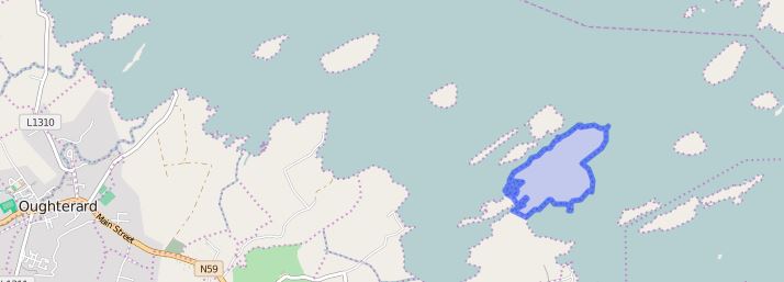
Maps
It is located at 53° 25′ 52″ N, 9° 14′ 39″ W.
Information from Google Maps:
You can use this link to find this townland on Google Maps.
Information from the National Monuments Service:
You can use this link to view a map of archaeological features. This link brings you to a website wherein you will have to search for your townland.
Archaeological map from the National Monuments Service
Townlands.ie Website
http://www.townlands.ie/galway/moycullen/kilcummin/oughterard/ard/


No Comments
Add a comment about this page