Annaghkeelaun
Antoinette Lydon

Annaghkeelaun is in the civil parish of Kilcummin. The civil Parish corresponds with the following Church of Ireland parish of Kilcummin, Galway West. In general the civil parish and the Church of Ireland parish are the same as is the case in the Kilcummin Oughterard area.
The Irish Form of Name: Eanach Caolain
Translation: Keelan’s marsh
Other Forms of the Name
Annaghkeelaun
Eanach Caolain
Annaghkeelaun Boundary Surveyor
Annaghkeelane Barony Cess Book
Unnagh Caolan Local
Boundaries:
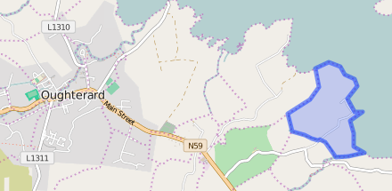
Annaghkeelaun is situated in the Northern extremity of the parish – bounded on the N. and E. by Lough Corrib, on the W. by Portacarron and Gurtreavagh, and on the S. by Knockillaree and Ardnasillagh.
Area:
Annaghkeelaun contains 145¾ acres of land of which about 70 acres of it is arable, the remainder is bog. Corribview House is situated close to the eastern shore of Lough Corrib. There is a quarry on the east side of an old road to the south of the house.
Placenames within townland:
Corribview (house) – The home of the Doig family in the Oughterard area, occupied by George Cottingham in 1855 who held it from John Doig. The house is now run as a B&B.
Previous proprietor/landlord:
Francis Blake (1641)
Forster (Blake Forster) – The Forster family were of English origin who first acquired property in Galway in the 1640s. The progenitor of the family in county Galway was Francis Forster who was the son of Thomas Forster of Hunsdon, Hertfordshire. He obtained the Clooneene/Ashfield property by Royal grant from Charles II dated 18 Aug 1677 and chose to live there from then on. Francis married Mary O’Donnellan, daughter of Sir James O’Donnellan. The family also had houses at Rathorpe and later at Fiddaun as well as in county Clare in the parishes of Kilfenora and Drumcreehy. Francis Forster, who inherited the estate in 1752, married Anastasia Blake of Menlough and the family became known as Blake-Forster. The estate at Ashfield passed from the Blake Forster family in the 1830s. The Abbeyknockmoy estate situated in the baronies of Tiaquin and Athenry, county Galway, also belonged to the Blake Forsters. Samuel Lewis writing in the 1830s refers to a grant of Abbeyknockmoy by James I to Valentine Blake in 1629. This estate of almost 4,000 acres was offered for sale in Oct 1851. A newspaper cutting with the rental in the National Archives records the purchase of the unsold portions of the estate by Dominick Donnellan and Richard C. McNevin, a relative and agent to the Blake Forsters. By the time of Griffith’s Valuation, a few years later, Donnellan and McNevin’s purchases were in the possession of Martin J. Blake of Ballyglunin and James Thorngate. In the 1870s Captain Francis Blake Forster owned 3,593 acres in county Galway and 1,308 acres in county Clare, while Robert Blake Forster of Corofin, county Clare, owned 572 acres in county Galway. In 1906 Marcella Blake Forster owned over 250 acres of untenanted land and a mansion house at Corr, in the barony of Longford. An offer from the Congested Districts Board on a small acreage owned by Miss M. L. Forster was accepted sometime after 1909.
Arthur French St. George of Tyrone House (c. 1850)
St. George – Richard St George, a member of a Cambridgeshire family, came to Ireland in the 17th century and was appointed Governor of the town of Athlone. His grandson Richard St George of Carrick on Shannon, county Leitrim, had 2 natural children, Richard St George founder of the Hatley Manor, county Leitrim branch of the family and Mary St George, who married James Mansergh and they were the parents of Colonel Richard Mansergh St George of Headford, county Galway. Members of the family served as High Sheriffs of Leitrim in the eighteenth century. Charles Manners St. George and his Swedish wife Christina were the owners of the St.George estate in Leitrim in the mid-19th century. Petronella Halberg, niece of Christina St George, married Charles Whyte of Newtown Manor and the Whytes inherited Hatley Manor and much of the St George property. The representative of Mrs. St. George are listed as the owners of over 1600 acres in 1876. The family also held lands in counties Offaly, Roscommon, Tipperary (629 acres in the parish of Donaghmore, barony of Iffa and Offa East) and Waterford where Christina St George is recorded as the owner of over 1000 acres. Over 300 acres of Sir John St. George’s estate in the latter county was offered for sale in the Landed Estates Court in June 1878. Sir Richard St. George of Tully is recorded as a member of the Grand Panel of county Roscommon in 1828. In 1852 the Roscommon portion of the estate in the barony of Moycarn was offered for sale in the Encumbered Estates court. This was the property of Richard Bligh St. George and Thomas Baldwin St. George. However, it appears not to have all been sold as Kate St. George was a principal lessor in the parish of Moore, barony of Moycarn, at the time of Griffith’s Valuation. Her property was sublet from the Bishop of Meath. In the 1870s she is recorded as owning over 1700 acres in county Roscommon and was resident at Cheltenham, England.
St. George (Tyrone House) – The St. George estate was centred on the house at Tyrone, parish of Drumacoo, barony of Dunkellin, built about 1779. This had originally been a French estate but the family assumed the title of St. George in 1774 due to inheritance from the St. George family of Hatley Manor, county Leitrim. In the 1830s A.F. St. George owned Tyrone House and Kilcolgan Castle, his agent was J. O’Hara. Wm. Griffith of Dublin also acted as an agent for the St. George estate. Arthur French St. George is described as a resident proprietor in 1824. In the early 19th century the St. Georges also owned large amounts of land in the baronies of Moycullen, Ballynahinch and Clare, which they advertised for sale in the early 1850s. Land in the barony of Clare had been acquired through Arthur French’s marriage with a Kirwan in the late 17th century. A portion of the St. George estate, situated in the barony of Longford, was offered for sale in the Encumbered Estates court in November 1853. In 1870s the family owned 15,777 acres in county Galway. By the early 1900s, however, some of the estate had been sold and the house at Tyrone had been left empty for long periods. In 1914 over 3000 acres of an estate described as St. George and Concannon was vested in the Congested Districts Board. Many members of the family are buried in a church-style mausoleum in the cemetery at Drumacoo.
The Tithe Applotment Books:
About the Records
Tithes were a tax on agricultural produce which was payable by the occupiers of agricultural land. They were the main source of income for the parish clergy of the Church of Ireland (the largest Protestant church and the church established by law). However, in many parishes a large part of the tithes were ‘appropriate’, which meant that they were payable to a bishop, cathedral chapter or other ecclesiastical recipient, or were ‘impropriate’, which generally meant that they were payable to a local landowner. The parishes used in the Tithe Applotment Books are civil or Church of Ireland parishes, which often differ in name and territory from Catholic parishes, Acts of Parliament of 1823 and 1832 provided for the conversion of tithes into a fixed charge on land, and specified the average price of wheat or oats in the parish in the seven years before 1821 as the basis on which the tithes would be calculated. They also extended the application of tithes to pasture, where previously they had been levied only on tillage.
This change in the law resulted in the valuation of individual holdings in almost all parishes containing agricultural land, in order to assess the portion of the tithes for which each occupier of land would be liable. The apportionment was recorded for each Church of Ireland parish in a Tithe Composition Applotment Book. The information was collected and the amounts were calculated by two Parochial Commissioners, one of whom was appointed by the cess-payers of the parish and the other by the relevant Diocese of the Church of Ireland. This procedure was carried out in over 2,500 parishes between the years 1823 and 1837.
The Tithe Applotment Books are in a variety of formats, from a few pages sewn together to elaborately bound volumes. In most cases they are written in manuscript throughout, although some consist of manuscript entries on printed questionnaires. The information in the books is broadly uniform and generally includes at least the name of occupier; the size of holding, the valuation and the tithe payable. In some cases more detailed information is provided. Some volumes have maps and most have certificates and correspondence attached.
The sub-divisions of the parish were recorded. Some of these subdivisions, such as ploughlands, ceased to be in official use after the six inch survey of the Ordnance Survey was completed in the 1840s. Only productive land was subject to tithe, and the books usually distinguish between this tithable land and untithable land such as roads or mountains. Tithable land was in some cases classified by quality, and a money value was given to each class. In some cases the proportion of tithe payable to the rector, vicar or lay proprietor of the tithes was set out. The column for observations was sometimes completed, with information about commonage, for example.
There are a number of other points that should be noted. The acreages given in the Tithe Applotment Books are in Irish or Plantation measure, which is 1.62 times larger than statute measure. Only occupiers of land at the time of the tithe composition are recorded, so not all heads of households living in a parish at the time are included. Only rural areas are systematically covered, although inhabitants of towns who held plots of cultivable land are included. The equivalent tax in urban areas, Minister’s Money, has left few records.
The Tithe Applotment Books are an important source of information for a wide variety of researchers of pre-Famine Ireland. They provide the first surviving national list of the occupiers of land, and are used by genealogists as a partial substitute for returns of the 1821 and 1831 censuses of population, which were destroyed in 1922. They also record information on the quality of land, and provide information on pre-Ordnance Survey territorial divisions, some of which were not recognised after the 1840s.
The National Archives hold the original Tithe Applotment Books only for the twenty-six counties of the Republic of Ireland. The books for the six counties of Northern Ireland are held in the Public Record Office of Northern Ireland in Belfast. (http://titheapplotmentbooks.nationalarchives.ie/search/tab/aboutmore.jsp)
Information from the Down Survey Website:
The Down Survey website will tell you who owned this townland in 1641 (pre Cromwell) and in 1671 (post Cromwell).
Townland of ANNAGHKEELAUN
Down Survey Name: Annagh & Gortdrisagh
1641 Owner(s): Blake, Francis (Catholic)
1670 Owner(s): Matthews, Francis (Protestant)
County: Galway
Barony: Muckullin
Parish: Killcumyn
Unprofitable land: 27 plantation acres
Profitable land: 52 plantation acres
Forfeited: 52 plantation acres
Griffiths Valuation 1850’s
In Griffith’s Valuation the area was 145 acres 3 rood 8 perches with a land value of £26 0s 0d. Value of Buildings was £7 0s 0d, and the total value is £33 0s 0d.
Occupiers of the Land
George Cottingham. John Doig was the Immediate Lessor.
Poor Law Union Ireland
In Ireland the Poor Relief Act of 1838 divided into districts or “unions” in which the local taxable inhabitants were to be financially responsible for all paupers in the area. In 1898 the Poor Law Union was adopted as the basic administrative division in place of the civil parish and barony. Further subdivision into 828 registration districts and 3,751 district electoral divisions followed. Townlands were not arranged according to these divisions with parish and barony retained as a means to make comparisons with records gathered before 1898.
The 1838 Act
The main provisions of the 1838 Act were:
- The extension of the existing Poor Law Commissioners’ powers to Ireland, with the appointment of Assistant Commissioners who were to implement the Act in Ireland.
- The division of the country into Poor Law Unions based on Irish electoral divisions which were themselves made up from townlands.
- The creation of a Board of Guardians for each Union, two-thirds of whom were to be elected, the other third to be appointed ex officio.
- The setting up of a workhouse in each Union.
- The collection of a local poor-rate to finance the system.
- Assistance for emigration.
Initially, 130 Unions were created, based upon 2,049 electoral divisions. The divisions were composed of townlands, a peculiarly Irish unit, traditionally of 120 Irish acres in area. (Between 1848 and 1850, an additional 33 Unions were created by subdividing and reorganizing the boundaries of some existing Unions, particularly in the west of the country.
Boards of Guardians were elected annually on 25th March. Only rate-payers were eligible for election, which effectively disenfranchised most of the native Irish who were usually tenants at this time. Rate-payers were allowed between one and six votes depending on the size of a valuation of their property.
Census 1881/ 1891
The Table shows that there were 4 Registrar’s Districts and Electoral Divisions in the Oughterard Poor Law Union. The total area of the whole Union was 172,289 acres. The table gives the number of houses and the population for each district from 1841, 1851, 1861, 1871, 1881, to 1891.The divisions of the Oughterard Union were Kilcummin, Letterfore, Oughterard and Wormhole. The total number of houses listed in 1841 was 4,465 and by 1881 there were 3,641 houses. The population in 1871 was 19,572 and by 1891 it was 18,975.
Census 1841/1851/1861/1871/1881
In 1841 there were 3 houses with 19 people living in Annaghkeelaun.
1851, 2 houses with 20 people,
1861, 5 houses with 24 people,
1871, 4 houses with 25 people &
1881 3 houses with 10 people (4 males, 6 females).
Townlands
A town land is one of the smallest land divisions in Ireland. They range in size from a few acres to thousands of acres. Many are Gaelic in origin, but some came into existence after the Norman invasion 1169. Annaghkeelaun is a townland.
Population & Census
You can retrieve a list of people who lived in this townland from 1827 to 1911. This list is compiled from the following resources.
- The Tithe Applotment Books
- Griffith’s Valuation
- 1901 Census
- 1911 Census
List of nineteenth century and early twentieth century inhabitants.
1901 Census Annaghkeelaun
This is a return of the members of the family, their Visitors, Boarders, and Servants who slept or abode in their house on the night of Sunday March 31st 1901 in Annaghkeelaun
There were 2 houses listed in the Townland of Annaghkeelaun. Of the people living in Annaghkeelaun all 6 were Roman Catholics.
People that lived in Annaghkeelaun were born in Co. Galway.
There were a total of 17 farm buildings and out offices which included stables, coach house, harness room, cow houses, calf houses, barns, piggeries, a dairy, a potato house & fowl houses.
Class of House: The class of house depended on the materials used in the roof, walls, number of rooms and number of front windows. A 1st class house was considered the highest standard.
Walls of the houses: The walls were of stone, brick, and concrete or of mud, wood or other perishable material. The houses in Annaghkeelaun were built of stone, brick or concrete. There were no mud cabins.
House Occupancy: 2 houses were occupied on the night of the Census.
George G Cottingham aged 50, head of the family married to Oliva A aged 30. They lived with their servants Mary Curter(Carter) aged 18, Tom Murray aged 30 & Patrick Nea aged 20. George was the County Coroner, Mary a domestic servant, Tom & Patrick were farm servants. George & Oliva were listed as educated. Mary, Tom & Patrick could read write & spoke Irish & English.
They lived in a 1st class house with 5 rooms and 10 front windows. They also had 2 Stables, 1 Coach House, 1 Harness room, 2 Cow houses, 2 Calf houses, 1 Dairy, 1 Piggery, 3 Fowl houses, 1 Barn, 1 Potato House & 1 Workshop. This premise was a Private Dwelling.
Mary Claney(Clancy) aged 59, a widow, lived alone, she was a farm servant, she could not read she spoke Irish & English.
She lived in a 4th class house with 1 room & no front window. She had 1 calf house. This premise was a Private Dwelling.
1911 Census Annaghkeelaun
This is a return of the Members of the families in Annaghkeelaun, their visitors, boarders and servants who slept or abode in the house on the night of Sunday 2nd April 1911.
There was 1 house listed in the Townland of Annaghkeelaun. The 4 (1 Male, 3 Females) people living in Annaghkeelaun were Roman Catholics.
People that lived in Annaghkeelaun were born included Co. Galway. There were a total of 12 farm buildings and out offices which included a coach house, store, stables, cow houses, barns, piggeries, and sheds.
Charles G Cattingham(Cottingham) aged 66, head of the family, married to Olive aged 43, they lived with their daughter Catherine Mary aged 9 & Julia Munly(Mealey/Melia) aged 19.
Charles was a ?(Coroner) & farmer, Mary Catherine a scholar & Julia a servant. The entire household could read & write. Charles spoke Irish & English. Charles & Olive were married for 11 years and had one child Mary Catherine.
They lived in a 1st class house with 5 rooms and 7 front windows. They also had 2 Stables, 1 Coach House, 1 Harness Room, 1 Cow house, 1 Calf house, 1 Piggery, 1 Fowl house, 1 Barn, 1 Work Shop & 1 Store. This premise was a Private Dwelling.
Church records of births, deaths and marriages:
Church records of births, deaths and marriages are available online at http://www.rootsireland.ie. To search these records you will need to know the ‘church parish’ rather than the ‘civil parish’. (The civil parish is the pre-reformation parish and was frequently used as a unit of administration in the past.)
Annaghkeelaun is in the civil parish of Kilcummin.
Catholic parish:
This civil parish corresponds with the following Roman Catholic parish or parishes.
- Clonbern & Kilkerrin in Galway East.
- Carraroe in Galway West.
- Kilannin in Galway West.
- Kilcummin/Oughterard in Galway West.
- Rosmuc in Galway West.
Church of Ireland parish:
This civil parish corresponds with the following Church of Ireland parish.
- Kilcummin in Galway West.
In general, the civil parish and the Church of Ireland parish are the same, but, this is not always the case.
Maps
Original OS map of this area :
Ireland was first mapped in the 1840s. These original maps are available online.
Original OS maps at the Ordnance Survey of Ireland website:
Below is a link to the Ordnance Survey of Ireland website. It displays the original OS map that was created in the 1840s.
Information from Google Maps:
You can use this link to find this townland on Google Maps.
Information from the National Monuments Service:
You can use this link to view a map of archaeological features. This link brings you to a website wherein you will have to search for your townland.
Archaeological map from the National Monuments Service
Galway Library
Link to Townlands.ie Website
http://www.townlands.ie/galway/moycullen/kilcummin/oughterard-ed/annaghkeelane/


No Comments
Add a comment about this page