

Introduction
Travel and transport is as old as civilisation, particularly by sea. The earliest inhabitants of Ireland came from overseas and they travelled widely within the country.
Celtic mythology indicates the extensive use of horse and chariot for persons travelling. The use of wheeled vehicles by the Celts would have required paved roads. Cormac Mac Art was King of Connaught and High King at Tara, 275-300 AD. Tradition attributes to him the five great roads of Ireland, which radiate from Tara to the north, south and west.
These may have been modelled on the dead-straight highways built by the Romans in Britain in the first century AD. Contact with Roman Britain would have taught the Irish the skills of road-building and their military and strategic importance.
These five great roads linked Tara and Dublin to different parts of Ireland, called An t-Slighe Mhór, Slighe Chualann, Sligh Mhídhluachra etc. The locations of the early roads depended to a great extent on the location of places of importance, for example royal seats, i.e. Tara, Rathcroghan, Aileach, Cashel and monasteries hospitable to visitors, i.e. Derry, Clogher, Durrow, Clonmacnoise, Roscrea etc.
An t-Slighe Mhór – The Great Road
This is a low ridge of sand hills (glacial gravel) called Esker Riada, which marks the dividing line between the north and south of Ireland, Leath Cuinn and Leath Mogha. It extended from Dublin to Galway on the west coast, and enabled journeys to be made across the bogland of the centre of Ireland. Some suggest that it was a pilgrimage road to Aran Islands of the saints – St. Enda. There was constant travel in the Middle Ages of lay and cleric, often on pilgrimage to Lough Derg.
Travel in Galway
When James Joyce visited Galway in 1912, he wrote that the names of some of the streets recorded their connection with Latin Europe, i.e. Madeira Street, Merchant Street, Spaniard’s Walk and Spanish Arch, Madeira Island.
During the Norman Conquest of the 12th century, Giraldus Cambrensis visited Galway. It was then only a small fishing village.
By the 15th century, it had become a centre of international trade, as its harbour bustled with foreign ships. From the 15th to the 18th century, Galway engaged in trade with France, Spain, Italy and Flanders. The trade was dominated by the fourteen leading Galway merchant families called the Tribes. The trade was in wine and other products. Travel by sea was much faster than overland.
In July 1538, Lord Leonard Grey, the Deputy of King Henry VIII, was the first Deputy to arrive in Galway. The Royal King’s Deputies regularly visited Galway for the rest of the 16th century.
In Tudor Ireland, roads were bad or non-existent. About 1580, Lord Deputy Sidney completed the bridge at Athlone, across the Shannon. The bridge over the Suck at Ballinasloe, which was the common passage to Galway, was built by Sir Nicholas Malby in the 1580s. In 1614, parliament passed the Highways Act, which made each parish responsible for the maintenance of its own roads.
Connemara in the Age of Cromwell, 17th Century
Galway was the last town to surrender to Cromwell’s forces in April, 1652. Inishboffin and the Aran Islands still held out under Irish and Royalist forces.
The Cromwellian campaign was launched from Galway. Six hundred soldiers were sent by land to subdue Iar-Chonnacht, or Connemara. The English soldiers marched west, through Oughterard, the fifty miles through the bogs of Connemara. This was the first time English soldiers ever penetrated into Connemara. The Aran Islands, Inishboffin and Clare Island, held by Irish and Royalist forces, were forced to surrender to Cromwell in February, 1653.
The Cromwellian soldiers planned to build a highway or road from Galway to Inishboffin, on the west coast of Connemara, to hold down Connemara, but none was built for the next 150 years. On 12th June, 1656, it was ordered that Lieutenant Colonel Hornor, Governor of the island of Inishboffin, Justice of the Peace, was to take care for the mending of the highway from Galway toward Inishboffin. The work was not effected because of the death of Cromwell in 1658 and the political changes with the restoration of Charles II soon after, in 1660.
Walter Macken, the novelist, who lived for fifteen years in Oughterard, wrote a historical novel, Seek the Fair Land, about Cromwellian Ireland. He describes Coote, Governor of Galway, with his forces, marching westwards through Connemara. They camp overnight at Moycullen, then visit Aughnanure Castle and Fough Castle in Oughterard, and onwards to Ballinahinch Castle, in the mid-17th century. They came under attack from the O’Flaherty clan on the march, who were on the side of the King against Cromwell.
Connemara in the 18th Century
By Act of Parliament, 1710, presentments (proposals) by the Grand Jury, which consisted of landlords and Justices of the Peace (JPs), were made fro the building and maintenance of the roads and bridges etc. Each barony had to bear the cost of maintaining its roads by the payment of a tax, called cess. This system remained in existence until the Local Government Act established elected County Councils in 1898.
During the 16th and 17th centuries, the only form of transport was on horseback or on foot. In the early 18th century, stage coaches travelled between the principal towns, radiating out from Dublin. By 1729, two stage coaches reached Athlone but none went as far as Galway.
The mail coaches began in 1789 and brought better and more regular passenger road services. In 1808, the first mail coach started from Dublin to Galway, with branches to Tuam, Castlebar and Westport. It had a double or treble guard armed with blunderbusses and pistols, because of the danger of being robbed by highwaymen. It set out from the Hibernian Hotel, Dawson St., Dublin each evening at 7.45 pm and took twenty-one hours to reach Galway.
From 1st June, 1832, the Galway-Oughterard mail coach travelled every day. The journey took three hours to the ‘spa town’. Although 1832 was the first time the dreaded cholera came to Galway, the advertisements in the Connaught Journal stated that Oughterard was free of cholera and encouraged people to visit the town and ‘spa’.
The Oughterard post office was opened in 1811 and Rosscahill in 1864. The postage from Oughterard to Dublin was 10d. The postmaster at Oughterard in the early years was Edmund O’Flaherty, a local landlord who also owned one of the two inns in the town.
The first mail coach operated from Galway to Clifden in 1837, a few years after the Oughterard-Clifden road had been completed. It also carried passengers and the journey took over seven hours.
In the early 18th century, much of the west of Ireland, and especially Connemara, was regarded as backward, uncivilised and a wasteland by opinion makers, and this opinion was to persist for most of the 18th century. It was the boast of Richard ‘Humanity Dick’ Martin (1754-1834) that the King’s writ (law) did not run beyond his gate lodge at Oughterard, which he said led to his thirty-mile avenue to Ballinahinch Castle.
Yet, by 1841, there was a population density of over 400 to the square mile along the coastline of Connemara, where most of the people had settled in earlier times, and along the south bank of Lough Corrib, from Galway through Oughterard, to Clonbur and Cong.
In 1825, the publication of the book Letters from the Highlands of Connemara put Connemara on the tourist map for the first time. It was written by the Blake family, who had settled in Renvyle in 1819, for an English audience, to encourage tourists to Connemara. It helped people to see that these wild Irish highlands of Connemara were not a savage wilderness but a place of beauty and welcome.
19th century travellers who visited Oughterard said the town was not in Connemara but the gateway to Connemara. Since Connemara was almost inaccessible due to lack of roads, very few ventured into it in the 18th century. Some of them described it from Galway.
Roderic O’Flaherty, the historian, in his description of Iar-Chonnacht (1684), does not describe modes of travel or transport. He wrote that Lough [Orbsen] (Corrib) was eight miles across and twelve miles in length, and that the distance from the river of Fough, Oughterard, to Galway was about twelve miles. James Hardiman, the historian of Galway who published his book in 1846, wrote that, for O’Flaherty, one mile was two modern British miles.
John O’Donovan, who visited Oughterard in 1839 for the Ordnance Survey, wrote that the reputed distance between Oughterard and Galway was fourteen Irish miles, but that O’Flaherty reckoned by the big Connaught miles. Most of the travellers accounts wrote that distances in Co. Galway were computed in Irish miles. Eleven Irish miles equalled fourteen English miles.
Travellers Accounts
Two English travellers described a visit to Moycullen in 1698 and 1709, i.e. John Dunton and William Molyneaux. Both came to visit Roderic O’Flaherty, the scholar and historian, who lived at Park, between Furbo and Spiddal.
In 1698, John Dunton wrote, “The tract of land westward of Galway is called Iar-Chonnacht, a wild mountainous country … I took a country fellow for a guide; otherwise, it would be impossible to travel, as in these mountains there are no inns or indeed roads … The next day, we betook ourselves to our horses … Some parts were so boggy that we had to dismount and lead our horses.”
William Molyneaux wrote about the same area, i.e. the barony of Moycullen, in 1709, “In all my life I never saw so strangely stony and wild a country … Nor could I conceive an inhabited country so destitute of all signs of people and art … Nothing appeared but stones and sea … Yet here, I hear, live multitudes of barbarous, uncivilised Irish, after their old fashions.”
In 1747, Stratford Eyre, Governor of Galway, said that there was no travelling by road beyond the town of Galway; beyond the West gate lay Iar-Chonnacht, a country inaccessible to wheeled carriages, inhabited by papists who supplied the markets with such necessities only as was brought on horse loads.
Judge Edward Willes visited Galway in 1761 on the Connaught Circuit (courts). He wrote that the bridge of Galway, built on a river, was the only entrance into Eyre Connaught, or Connemara.
He said this large tract of land was inhabited by the ancient Irish clan, the O’Flahertys, and other clans. They would never be made amenable to the law until roads were made through different parts of it. A good road was being made into the territory to a barracks eight or ten miles into the country from Galway. A hundred men from the garrison of Galway march there every week to protect the workmen, by an order of the Lord Lieutenant. When it was completed, the natives of the lawless country would be subdued and brought to obedience to the laws of the country.
This appears to be the building of the road from Galway to Oughterard in the mid-18th century. No doubt there was a rough path, suitable for horses and travellers on foot, long before that.
Oughterard town first appears on 18th century maps of Ireland. Sometimes Claremore is given for the town of Oughterard, which grew from the fair of Clareville, called Claremore in the late 17th and early 18th centuries, as recorded in the early almanacs.
In Moll’s 18th century map of Galway, the road from Galway to Oughterard is marked but no further roads from Oughterard into Connemara. A road around Lough Corrib is marked. There are no branch roads from Oughterard and Moycullen to the south seacoast, as they must have been paths in the 18th century. The old road from Glan to Castlekirk is not marked.
According to the Schools Folklore Collection (1937-38) for Oughterard, the old road from Oughterard to Glan existed for over 200 years and was there long before the Famine (1845-50).
Road Maps – 18th Century
The travellers by road in the coaching age had two useful reference books. In 1776, two mapmakers, George Taylor and Andrew Skinner, surveyed the roads of Ireland. They traced the routes and distances between the main towns, starting from Dublin, based on the 18th century milestones.
The map was published as a book in 1778 as The Maps of the Roads of Ireland. The Post Chaise Companion, based on this map and published in 1784, showed the road from Dublin to Galway via Banagher and described landlords seats. The policy of Taylor and Skinner was to survey every road fit for wheeled vehicles.
Oughterard was the terminus of the road into Connemara. After Oughterard, there was only a rough path or bridle road to Ballinahinch Castle, seat of the Martins. It was suitable for pedestrians or horses but not wheeled vehicles.
This map gives details of the road from Galway to Oughterard. It marks the landlords houses at Ross (Martins), Portacarron (French), Lemonfield (O’Flahertys) and Clareville (Martins). It also shows the old churches, rivers and byroads off the main road. It shows the old road to Oughterard turning right after Ross, through the townland of Fahy, and on to Laghtgarron by the road since called Barr An Fhearainn (the Top of the Farm). The new road to Oughterard across the bogland of Killola was built as a relief work during the Famine.
The military barracks in Oughterard is marked and Aughnanure as a castle in ruins.
The Traveller’s New Guide to Ireland 1815
This book gives the milestone distances from Dublin Castle to different places in Ireland.These milestones are given in the early road maps, such as Taylor’s and Skinner’s (1778). Some of these 18th century milestones are still visible and marked in parts of Co. Galway. A number of them are listed in this guide between Galway and Oughterard. The distances given are almost certainly Irish miles.
The book states that milestone 111 is situated at Moycullen Lake, on the right and overshadowed by the lofty pinnacle of the impending mountain. At milestone 112 stands Knockferry, near Lough Corrib. At milestone 114 are the three romantic lakes of Ross and the ruins of an old church on the right. At milestone 119 is Lemonfield. Oughterard town was a distance of 119¼ miles from Dublin.
The guide states that the road from Oughterard proceeds in continuation to Ballinahinch. The only high road from Ross barony is one winding from Cong through steep and craggy mountains to Oughterard.The rate of postage from Oughterard to Dublin at the time (1815) was 10d.
Other Accounts
Travellers who went beyond Oughterard into Connemara experienced great difficulties in travel. The young French nobleman De Latoenage had walked fourteen or fifteen miles from Galway to Sir John O’Flaherty at Lemonfield in 1796. After Oughterard, he used a horse supplied by Sir John to visit Richard Martin at Ballinahinch Castle.
He said that, after Oughterard, he was often obliged to dismount to avoid the quagmires, as he did not think the beast could bear a rider. It was not easy to find the way, as there was scarcely the appearance of a path and the cabins were few and far between, but the peasants he met were helpful and polite.
The novelist Maria Edgeworth, and her friend Sir Culling-Smith and his wife, had great difficulty in travelling the route in 1834. As the new road was not yet finished, they had to take the old bog road. Her friend Sir Culling-Smith insisted on travelling by carriage, with four horses and postillions. The horses and carriage foundered and sunk in the sloughs and steps on the route. They could only navigate the last mile by the assistance, for the horses and carriage, of a group of local men and boys, as far as Ballinahinch.
The Roads in the 19th Century
Hely Dutton, in his survey of Co. Galway (1824), wrote that the roads of this county are generally good, as the best material, either broken stones or good gravel, abounds in almost every part of it. He said that the road from Galway to Oughterard is wide and remarkably well made, but the loose stones that are permitted to roll about the road are a serious drawback to the pleasure of travelling.
This road dates from the mid-18th century, as described by Judge Willes in 1761. At that time, road building was carried on by the Grand Jury, consisting of local landlords of the barony, but the cost had to be borne by the ordinary people in a tax called cess. This system lasted through the 19th century.
Alexander Nimmo, the Scottish engineer, described the road from Galway to Oughterard in the early 1830s as a tolerable coach road. The mail car did the route at the time in three hours.
Hely Dutton wrote that, when Mr. D’Arcy went to reside at Clifden in 1816 he could scarcely ride into Connemara, especially after Oughterard, but now in 1820 he is enabled to drive a coach and four horses in hard from Galway to Clifden, a distance of nearly 50 miles. This was unlikely in 1820, according to other traveller’s reports.
The road network in Connemara was laid down by Alexander Nimmo, the Scottish engineer who arrived in Connemara in 1812 to survey the bogs west of Lough Corrib. He was appointed engineer of the Western District in 1821, which included Connemara. Due to his work, new roads began to penetrate Connemara in the early decades of the 19th century.
The road from Oughterard to Clifden, by Maam Cross, meant that settlement spread from the coast to the interior, which was almost empty of population.
The roads in Connemara, as well as promoting outward trade, facilitated tourism, so that tourists could view the beautiful and picturesque scenery of this romantic district. The Martins of Ballinahinch used to spend the winter at Clareville, Oughterard and summer at Ballinahinch Castle, due to the poor road conditions.
Up to the early 19th century, most of the population of Connemara lived along the coastline and on the west coast of Lough Corrib, from Galway through to Oughterard, Clonbur and Cong, with a very sparse population of about 300 families in the interior. Road building brought people into the interior of the country.Due to lack of roads, there was a special importance in the coastline trade of currachs and hookers, which brought turf from Connemara to Galway, the Aran Islands and north Clare. Turf was also brought by boat on Lough Corrib from Oughterard to Galway and between Oughterard and Cong.
Kelp made from seaweed was one of the most important industries in Connemara from 1700. It was exported by sea along the coast to other ports of Ireland, i.e. Cork and the textiles hinterland of Belfast. Iodine was manufactured from kelp.
When the Board of Public Works was established in 1832, one of its functions was to provide public relief works in time of economic distress or near-famine.
In 1818, Thomas B. Martin, assisted by John D’Arcy, obtained a presentment under the Grand Jury for a road to link the new town of Clifden to Galway. John D’Arcy, the landlord who founded Clifden, was interested in providing suitable roads as part of his plan to develop the new town of Clifden, begun in 1815 on the west coast of Connemara.
The part of this road between Oughterard and Clifden, instead of going over steep hills as the old road did, ran for nearly thirty miles with scarcely any difference in the level. The old road, or rough path, from Oughterard to Ballinahinch, ran close to where the railway line was built in 1895.
This new road was carried out largely as a relief work to provide employment in the economic crises which preceded the Famine. It was under the supervision of Alexander Nimmo, and his successor John Killaly, engineers of the Western District, and was completed in 1834 after eighteen years.
There were also a number of other roads, bridges and piers completed in the barony of Moycullen, which provided employment for the people in the decades before the Famine. A local newspaper reported on June 12, 1824, that 600 persons were employed on building a road from Moycullen to Knockferry. They were paid five quarts of meal (oatmeal) made from oats each day, in lieu of money, and a similar amount for women. At that time, the report stated, there was no less than 1,276 working on one road, and 575 on another, in Connemara.
William M. Thackeray, the novelist, travelled through Connemara by mail car in 1842. A peasant told him that only thirty years before, i.e. 1812, Ballinahinch Lake was three days distance from Galway. The Galway Weekly Advertiser wrote on June 1st, 1825, “We would hardly wish our greatest enemy worse than to be obliged to travel in a four wheel carriage from Galway to Clifden.”
By the mid-1820s, the road from Spiddal across the hills to Moycullen, and on to Knockferry, was completed. The Connemara coast road from Spiddal to Costello Bay was being extended. By 1833, the road from Spiddal to Moycullen had cost £1,836. The road from Galway to Clifden cost £3,499-17s-4d. The road from Galway to Oughterard being improved cost £571-16s-11d. The new road from Oughterard to Clifden had cost £2,928.
Larkin’s Map of Co. Galway
William Larkin’s Grand Jury Map of Co. Galway (1819) was the most detailed map of the county until the Ordnance Survey maps of the 1830s. At that time, the Connemara road network was beginning under Alexander Nimmo, the Scottish engineer, with the support of the local landlords, T. B. Martin, John D’Arcy etc.
This map shows the old road from Galway to Oughterard, which branched off to the right at Ross, and on through Fahy townland, before the more direct new road through Killola bogland was constructed at the time of the Famine. Byroads, or secondary roads, are also marked, i.e. the road to Porridgetown and Ardnasalla, the road from Moyvoon to Aughnanure and the Portacarron road.
The main coast road from Spiddal westwards was incomplete, called Bóthar An Rí. There were no back roads across the hills from Moycullen or Oughterard to the south coast, apart from rough paths.
The lines drawn on Larkin’s map give the impression that there was a central Connemara road from Oughterard to Ballinahinch and Clifden. As already noted, this old road was only a rough path to Ballinahinch, which could only be negotiated by a horse and good rider in summer and was scarcely passable in winter.
The road along the south shore of Lough Corrib to Glan and Clonbur is marked as a developed road but it was only a rough byroad in 1819.
The map gives many features in the vicinity of Oughterard: townlands, bogs and islands of Lough Corrib.
A Topographical Dictionary of Ireland (Samuel Lewis, 1837)
Samuel Lewis produced a map for each county, which he described in his Dictionary. He put an emphasis on roads and communications. Lewis stated that in Co. Galway the roads were numerous and generally in excellent repair, as materials for making them were everywhere abundant and good.
Several new lines had been made through the western part of Connemara. One new line, commencing at Oughterard, proceeds by the lakes to Ballinahinch and Clifden, with numerous branches from it into the centre of the mountains. Another line passes from Clifden to Westport through the Killeries.
These lines seldom deviate from the level, although carried through the midst of the mountains, extending in all 127 miles.
The Oughterard-Clifden new road had been completed a few years before Lewis produced his work. The map of Co. Galway accompanying his Dictionary shows the roads completed in the vicinity of Oughterard and some of the byroads (the road from Spiddal to Moycullen and Knockferry, across the hills, had been completed by 1830).
His map traces a road from the south coast of the barony of Moycullen, near Cashlah Bay, across the hills, which links the road between Rosscahill and Oughterard, by Lough Buffy and the Drimnear river. This was an old road but is now only a rough path.The main trunk road network through Connemara had been laid down at the onset of the Famine, or by the late 1840s. A survey of 1844-45 stated that one excellent carriage road made a circuit of the whole coast of Connemara. Another linked Costello Bay and Galway, and there was a valuable road from Galway to Oughterard and to Clifden, with many subordinate roads and quays (piers).
Roads Built During the Famine
Road works took place during the Famine (1845-50) as public relief works. Their purpose was to provide employment for the poor and starving so that they could buy sufficient food (Indian meal) to feed themselves and their families, as the potato crop had failed.
The usual wages were 8d to 10d per day for adults, and one shilling per day in Moycullen parish during 1847.
These relief works took place in 1846-47 but only lasted for about eighteen months and were then ended, so that most of the roads begun remained unfinished.
The road works in the barony of Moycullen in 1846-47 were as follows: the Costello Bay road to the Oughterard-Seanafeistin road; the Knock road, near Spiddal, to Leiter and Doon; the Deerfield road to Ower; the Lettermore road to Goldenhead; the Rosmuck road; a line of road from Turlough to Collinamuck; and from Danesfield, Moycullen to Oughterard. These roads criss-crossed the barony of Moycullen.
In the vicinity of Oughterard, the relief works were: the new road to Glan; the road to Magheramore; and the road from Rosscahill to Kilaguile (New Line).
The official government records reported that from five to eight thousand were on the relief works in the barony of Moycullen, the whole of south Connemara, at different times during 1846-47. In June, 1846, 300 men were reported to be on the public works in the Oughterard district.
On the Costello Bay road to Oughterard-Seanafeistin, five miles at each end were made but the rest remained incomplete till the early 20th century.
Large numbers were employed on these relief works for periods in 1846-47 but they did not save people from starvation and death. The public works scheme failed. The wages were insufficient for large families. There were constant stoppages and, in the end, the system became unworkable. The public works were ended in July, 1847, and were not resumed.
For the rest of the Famine period, the people had to depend on their own resources to survive, or enter the workhouse.
The Ordnance Survey Maps
The Ordnance Survey was begun in the 1830s by two Royal Engineers, Thomas Larcom, its director, and Colonel Thomas Colby. The survey was carried out by army engineers and soldiers. The maps were drawn up by draughtsmen, using the most modern techniques for accuracy. By 1846, they had drawn up maps for the whole of Ireland at a scale of 6 inches to the statute mile.
John O’Donovan, a Gaelic scholar who visited Oughterard in 1839, compiled the Ordnance Survey Letters for each county. The survey’s main focus was maps but they also studied written records (ancient and modern), place names of townlands, and local history and traditions. Their sources of information were landlords, clergy, schoolmasters, farmers etc.
All modern maps of Ireland are based on the Ordnance Survey of the 19th century.
The first edition of the Ordnance Survey maps (1837-42) gives all the townlands by name (anglicised), and their acreage, in the parish of Oughterard. The town of Oughterard is shown spread out along the Owenriff river. All the main roads, byroads and paths are shown in the parishes of Oughterard and Kilannin, with many other features (old churches, holy wells, graveyards etc.).
The second edition of the Ordnance Survey maps (1899-1902) shows the changes that took place in the landscape after the Famine. It shows the new, direct road through the bogland of Killola to Oughterard. The Midland Great Western Railway, from Galway to Clifden, had opened in 1895, a few years before the survey. This map shows the railway station at Oughterard and the Union workhouse, which opened in October, 1849.
The Ordnance Survey Letters, Co. Galway (1838-39), by John O’Donovan, contains a map of the barony of Moycullen by Sir William Petty from 1655-57. It gives much detail of the barony in the mid-17th century but does not mark roads or paths. The boundaries between the parishes of Kilcummin, Kilannin and Moycullen are marked, as well as rivers, lakes and place names of some townlands.
Modes of Transport: Bianconi Cars (Charles Bianconi, 1785-1875)
A transport revolution was brought about in Ireland by Charles Bianconi, an Italian businessman called ‘King of the Roads’, who came to Ireland at the age of fifteen. The end of the Napoleonic Wars in 1815 flooded the market with cheap horses and cars, and Bianconi seized the opportunity and built up a network of services operated by coaches and horses.
He ran the first coach service from Clonmel to Cahir in 1815. By the early 1830s, his cars linked the main towns of Connaught, north and west. At his peak, he covered over 4,000 miles of road with a fleet of 900 horses and 67 cars, which were maintained at his vast stables and coach house near Clonmel. He was elected Mayor of Clonmel in 1844.
With the coming of the railways in the 1840s, he adapted his coach business to provide ‘feeder’ services between stations.
The Bianconi cars were elongated side cars, with passengers seated on either side (seven on each side). They were driven by four horses, travelled at eight to ten miles per hour, with a modest fare of 1¼d per mile from each passenger. They were affectionately known as ‘Bians’. He was given the contract to carry the mail, as well as passengers, because of his regular services.
In 1837, Bianconi began a service of one four-wheeled car, each way, every day, from Galway to Clifden, 49.5 miles from Eyre Square, Galway. When Bianconi retired in 1866, his agent, K. O’Brien of Galway, purchased this service and kept it in operation until the Galway-Clifden railway was opened in 1895.
Most passengers were satisfied with the Bianconi long cars, as it was the only means of transport at the time and the fare was cheap. In 1870, a single fare from Galway to Clifden was 7s-6d, plus whip money for the driver, and the journey took seven hours. There was no covering on the cars, so a supply of rugs and waterproofs was essential.
In 1858, a German traveller, Rodenberg, set out from Galway to Clifden. He said that the only means of transport was provided by Bianconi Royal Carriages. The travel by this means was absolute torture for Rodenberg. They did not provide proper footrests, so that your feet kept dangling in the air. The wheels were not protected by mudguards and passengers got splashed all over. At the slightest incline, the passengers had to alight. He said that the arrival of the daily Bianconi seemed to be the only diversion for the people of Oughterard. A group of people congregated around the car.
There are descriptions from near Oughterard and Moycullen of the Bianconi car and its arrival. Francis B. Head, an English travel writer, described the car which he met at Oughterard in 1852:
“Near Oughterard, we met one of Bianconi’s jovial, well-appointed cars, on one side of which sat, very comfortably together, like a couple of hooded crows on a rail, two fine, ruddy, powerful-looking priests – next to them were two English tourist ladies; then, of course, two young tourist gentlemen; and on the opposite bench, dos-a-dos to priests, ladies and company, half a dozen more of His Majesty’s subjects, all evidently in search of the picturesque.”
Daisy Burke, later the Countess of Fingal, grew up in Moycullen in the 1860s. She described the coming of the Bianconi car to Moycullen and its effects:
“Then comes the trot-trot of horses hooves. The Bianconi car goes from Galway to Clifden, carrying passengers and mails, our touch with the world. The mail, carried in the well of the long car, brought regular money home from America to make life easier for the old people. When the long car brought parcels besides the mail, the conductor was a sort of general manager for the people of the village, with food supplies, tea, sugar, tobacco etc.
The arrival of the Bianconi long car was the great event of the day in all the villages through which it passed and the whole population would turn out to receive it. Presently, the horses are whipped up again. I hear the sound of wheels and the car goes on its immense journey to Oughterard, where the horses are changed, and takes the road that had been once ‘Richard Martin’s Avenue’ to Clifden and the coast.”
Guidebooks
Account of Mr. and Mrs. S. C. Hall
Mr. and Mrs. S. C. Hall, travel writers, visited Oughterard in 1841 and again in 1852. Among their books were four Handbooks for Ireland, one volume of which was The West and Connemara. The books encouraged tourism and visitors to the west of Ireland.
In 1852, they wrote that:
“For a long time Connemara was utterly unknown to the English, or even the Irish themselves. There was hardly any road over which wheeled carriages could pass. But now, roads have opened up in all directions through the district, and its mountains and glens made accessible to traffic.
On arrival at Galway, the tourist will pursue his course to Connemara either by Bianconi car, which makes the tour daily and carries fourteen passengers, or jaunting car. The Bianconi cars run twice a day through Oughterard to Clifden.
The two inns at Oughterard, Murphy’s and O’Flaherty’s, are at the two ends of the town and are but ‘so-so’; the former has advantage over the latter and they make up about twenty beds between them. There are inns at Oughterard (2), Maam (1), Recess (1), Ballinahinch (1) and Clifden (2) in Connemara, and the Halfway House between Oughterard and Clifden, and the charges are moderate.”
In the second half of the 19th century, tourist guides were published which gave information on tourist routes, car services, maps, inns, fares etc. The Midland Great Western Railway also published handbooks, even before the railway from Galway to Clifden was opened.
Black’s Guide to Galway, Connemara, Shannon and Lough Erne (1870)
This guide wrote that:
“Oughterard is about 17 miles by road from Galway. Though styled a post town, it is nothing more than a village.”
The guide describes Aughnanure Castle, the O’Flahertys, and Oughterard town and its neighbourhood. The guide stated that many tourists prefer to sail up the lake by steamer from Galway to Cong, and overland by hired car to Maam and on to the Halfway House, where the mail car can be intercepted.
After opening the railway to Galway, the Midland Great Western Company published handbooks and began to organise Connemara tours.
Handbooks to Connemara and the West of Ireland (Midland Great Western Railway, 1882)
“The tourist can reach Connemara by taking the daily four-wheeled public car from Galway to Recess and Clifden, and visit in easy stages by hired cars the various points of interest in the district. Steamers ply from Galway on Lough Corrib to and from Cong. The distance from Galway to Oughterard is 17 miles. It is picturesquely situated and contains 155 houses and 890 inhabitants on the river Owenriff.”
“Lough Corrib is about a mile distant from the town and boats can be obtained to cross the Lough to Cong, nine miles, fare 5s to 6s. A single fare from Galway to Clifden by car costs 7s-6d and takes seven hours from Eyre Square, 49½ miles. Cars can be hired by tourists stopping at Oughterard to explore the district.”
“The vicinity of Oughterard has here and there been planted with trees, which gives a Sylvan appearance rather exceptional in the western highlands.”
Black’s Guide to Galway and Connemara (1905)
It gives a description of Aughnanure Castle.
“Oughterard is a village 17 miles from Galway, of 810 inhabitants. The railway and the road runs from Galway to Clifden and the surface of the road is good. The village contains the Angler’s Hotel and Murphy’s Hotel. There are secondary roads along the coast to Inverin, a road from Costello Bay to Oughterard, and from Spiddal to Moycullen. The visitor can travel by steamer on Lough Corrib to Cong and then by car, via Clonbur and Maam, to Maam Cross, Recess and Clifden.”
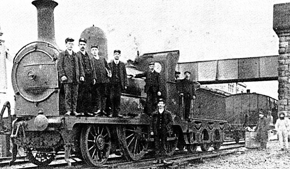
The Railways
The first train of the Midland Great Western Railway from Dublin to Galway began on 1st August, 1851. The mail (letters, etc.) arrived from Dublin by train in 5 hours and 10 minutes, and took 3 hours to reach Oughterard. Mail from Dublin dispatched at 8.20 am arrived at the post office in Oughterard at 4.10 pm, i.e. 8 hours over a distance of 151 miles.
The train fare from Dublin to Galway in 1851 was from 20s (First Class) to 6s (Fourth Class).
The first proposals for a railway from Galway to Clifden were made in the 1860s. Some favoured the route from Galway along the coast, with the greatest concentration of population. Others favoured the more direct route through Oughterard, although more sparsely populated.
In 1862, the railway had been projected from Galway to Oughterard and the local residents were most anxious to have it carried out. But the Law Life Society of London, an absentee landlord company, through whose estate twenty miles of the railway was to run, did not support the scheme, which caused delays in the 1860s. When Richard Berridge became owner of the former Martin estate in 1872, he and his son, Richard Junior, supported the railway scheme.
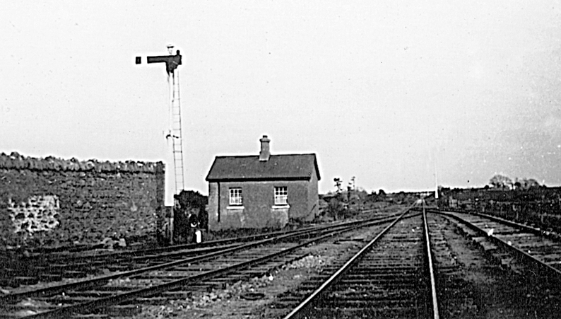
In the end, the Midland Great Western Railway Company undertook to build the line from Galway to Clifden via Oughterard, i.e. the inland route. The government granted £264,000 and the Midland Company £146,000 extra, plus £35,000 rolling stock, towards its cost. It was to be a single line with seven stations, Moycullen, Ross, Oughterard, Maam Cross etc.., with a cost of £5,000 a mile. It opened in 1895.
The purpose of the railway was to open the countryside and to promote tourism and fisheries in Connemara.
Major engineering works were the viaduct (bridge) over the Corrib river and the blasting of a 700-yard, 25-foot, section of rock at Oughterard. The railway gave large-scale employment along the line while it was being constructed, from 1890-95. A thousand were employed in 1890 and this increased later.
Wages during the construction were almost twice farm wages, at 14s per week compared to 8s to 9s per week for farm labourers. Several strikes along the line increased the wages from 12s per week to 14s and 15s per week.
The railway had three trains each way at first and one on Sundays. As it became popular with tourists, the Midland Great Western Railway Company started a Tourist Express in 1903, from Dublin to Clifden non-stop (the fastest ever on the line). In 1898, three years after the line was opened, the company built a fine hotel at Recess, overlooking Glendalough Lake.
The railway brought many tourists and anglers into Connemara but it served in the main for the transport of emigrants from Connemara to America and England. It provided easy transport of fish caught at Oughterard to the London markets and brought anglers and tourists to Oughterard for the mayfly season.
By 1907, there were three hotels in Oughterard but not sufficient rooms for all the visitors. Since 1900, an average number of 125 tourist anglers (fishermen) visited Oughterard each year. Some of them stayed for two months and spent a total of £14,000 in the district.
The railway ran along the south side of the road from Galway. By the 1930s, the line was not an economic success and was a heavy drain on the finances of the company. It had never paid its way and was finally closed on 2nd April, 1935. It was replaced by a fleet of buses.
The opening of the railway to Clifden in 1895 displaced the mail car services from the route but similar cars continued to bring the tourists onwards to Westport.
Train Fares
In June, 1898, the Galway Express gave details of the train fares and times (Railway Time Tables) on the Galway-Clifden route, as follows.
Cheap Excursion Tickets: On Sunday 19th June, 1898, a special train will run from Galway to Clifden. Return tickets at the following low fares.
Galway Departure: 10 am
Oughterard Arrive: 10.48
Clifden Arrive: 12 noon
Return Tickets: 1st Class – 5s-0d; 3rd Class – 2s-6d
Oughterard to Galway: 1s
Oughterard to Clifden: 4s
– Joseph Tatlow, Broadstone Station, Dublin
Oughterard to Dublin Excursion Return Tickets: Wednesday June 29th, 1898
1st Class – 20s-0d
3rd Class – 12s-6d
In 1911, there were special return tickets on market days, Wednesdays and Saturdays.
Ross to Galway: 1st Class – 2s-8d; 3rd Class – 1s-5d
Moycullen to Galway: 1st Class – 1s-8d; 3rd Class – 10d
Motorbus Passenger Services
Motorbus passenger services were provided to Ireland in 1904 and continued to grow. The speed of the Bianconi cars was between 6 and 7 miles per hour.
By 1910, motor services were freely available and, in 1911, the Midland Great Western Railway decided to operate a Clifden-Westport service, as well as a Galway-Oughterard-Clifden service.
Some of the travel writers who visited Oughterard in the first half of the 20th century travelled by train, motor, or bus.
The Galway-Clifden railway was called the Balfour Train, as Arthur Balfour, as Chief Secretary for Ireland, had brought forward the Act in parliament which established it.
The Irish Times of 2nd August, 2012, published a photograph of an early motor car (1898-99) at Ross House, home of the Martins, Co. Galway. It was three-wheeled, with two passengers (the driver and the passenger).
References
Nowlan, K. B., Travel and Transport in Ireland, Dublin, 1973
Curtis, E., A History of Ireland, London, 1936
Atlas of Irish History, London, 1973
Kelly, C., The Grand Tour of Galway
Hardiman, J., A History of the Town and County of the Town of Galway, 1820
McCurtain, M., Tudor and Stuart Ireland in Gill History of Ireland, Dublin, 1972
Kilroy, P., The Story of Connemara, Dublin, 1989
Hardiman, J. (Ed.), A Charographical Description of West of H. Iar Connaught by Roderic O’Flaherty (1684), Dublin, 1846
Macken, W., Seek the Fair Land
Maxwell, C., The Stranger in Ireland, Dublin, 1954
Thom’s Almanac and Directory, Dublin, 1819
The Connaught Journal, 14th June, 1832
Lewis, S., A Topographical Dictionary of Ireland, Vols. I and II, London, 1837
Blake, H., Letters from the Irish Highlands of Connemara, 1825
Lynam, S., Humanity Dick: A Biography of Richard Martin MP, 1754-1834, London, 1975
Daly, M. E., Social and Economic History of Ireland Since 1800, Dublin, 1981
MacLysaght, E., Irish Life in the 17th Century, Cork, 1950
The Letters of Chief Baron Willes to Earl of Warwick, 1757-62, 1990
The Dublin Almanac, 1761
Prendergast , M., Moll’s 18th Century Map of Galway, National Library of Ireland
Taylor and Skinner, Maps of the Roads of Ireland, 1778
The Post-Chaise Companion, 1784
Cummings, J., The Traveller’s New Guide to Ireland, Dublin, 1815
De Latoenage, A Frenchman’s Walk Through Ireland, 1796
Sommerville Large, P., The Irish Country House: A Social History
Dutton, H., A Statistical and Agricultural Survey of Co. Galway, Dublin, 1824
Edgeworth, M., A Tour of Connemara
Moody and Vaughan, Eighteenth Century Ireland
A New History of Ireland, 1986
West, N., Decoding the Landscape
Cawley and Scanlan, Connemara
Galway Weekly Advertiser, 24th June, 1824
Thackeray, W. M., The Irish Sketchbook, 1842
British Parliamentary Papers, Vol. 35, 1833
Larkin, W., Grand Jury Map of Co. Galway, 1819
The Parliamentary Gazeteer of Ireland, 1844-45
Parliamentary Papers – Distress Papers, No. 2649, 1846
Schools Folklore Collection (Oughterard Schools), 1937-38
Hickey, D. J. and Doherty, J. E., Dictionary of Irish History Since 1800, Dublin, 1980
Boylan, H., A Dictionary of Irish Biography, Dublin, 1977
Flanagan, P., Transport in Ireland, 1880-1910, Dublin, 1969
Head, F. B., A Fortnight in Ireland, 1852
Elizabeth, Countess of Fingal, Seventy Years Young, London, 1937
Hall, S. C. (Mr. and Mrs.), Handbooks for Ireland – The West and Connemara, London, 1853
Black’s Guide to Galway, Connemara, Shannon and Lough Erne, 1870 and 1905
M.G.W.R. Company, Handbook to Connemara and the West of Ireland, 1882
Thom’s Directory and Almanac, 1852
Tuthill, K. V., History Ireland (Winter), 1995
Semple, M., Reflections on Lough Corrib, Galway, 1974
Galway Express, 11th June, 1898


No Comments
Add a comment about this page