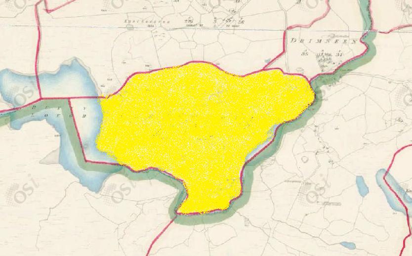
Carrowndulla
Townlands of Oughterard
By Paul Gibbons

Anglicized from Irish: Ceathrú an Dola or Ceathrú na dTuile
Translates to: “The Quarter of the Loop” or “The Flooded Quarter”
Etymology:
The term quarter when used in surveying and homesteading refers to a squarish tract of land which is roughly quarter a mile long on each side thus containing 160 acres (aka a quarter of a square mile). Carrowndulla although not square shaped does contain, as it was measured in the mid 1800s, just off 160 acres of land (over 156 acres). Although the official Irish name is recorded as ‘an dola’, it could also be anglicized from ‘na dtuile’, as they sound similar. The townland is bordered on the north-west by Lough Buffy and along its entire southern limit by the Drimneen River so it is therefore likely that the land was regularly flooded hence the name ‘the flooded quarter’. Alternatively the term ‘quarter of the loop’ could refer to the fact that the river loops around the area creating its southern boundary.
Size: 156 acres, 0 rods, 29 perchs
Siting:
In the northern part of the parish. Bounded on the north by Raha and Drimneen and on the south by Kilannin Parish (Buffy & Killaguile).
Description:
Land not bad. Contains 156 and a quarter acres, the quarter of which is under tillage but it is of a very inferior quality. There are 17 acres of water included in this area. There is nothing remarkable in this townland but an ancient fort is situated near its southern boundary.
Placenames within townland:
Knocknalecka (hill) – Translates to ‘hill of the flagstone’. A very high hill with a triangulation station on it.
Enclosure (arch. remains) – On a south facing hillslope overlooking the Drimneen River. Marked on the 1st ed. 6 inch map as a circular enclosure (diameter c. 20m) and referred to as an ancient fort in O’Donovan’s Field Name Book. No visible surface trace survives.
Corn mill – A mill located where the Drimneen River meets Carrowndulla Lough.
Carrowndulla Lough (lake) – A small lake to the south of Carrowndulla which forms part of the Drimneen Rover.
Previous propreitor/landlord:
Nicholas More Lynch (1641)
Robert Martin (1670)
Thomas B. Martin of Ballinahinch Castle (c. 1850)
Land Value (1857): £32 s.10 d.0
Buildings Value (1857): £2 s.5 d.0
Surnames attached to the townland (1857-1911):
Fahy, Newell, Molloy, Lydon, Hanly


Comments about this page
Carrowndulla Townland It appear that Carrowndulla became populated in the Cromwellian period. There are different stories as to the overall population. Local folklore indicates that it had a high percentage of weavers. The story is “What was shorn in the morning was worn in the evening”. Nicholas Martin of Ross Estate made a record in March, 1811 that he had let the “Lough field in Cnock an arim (Gortacarnaun) to Patrick Kelly and partners of Corindullow for one year at £9 -2 – 0. It measures 4 acres 1 rood and 36 perches”. 1841 census – Population 130 – 62 male and 68 female. Number of houses 28; 1851 census – Population 70 – 35 male and 35 female. Houses 14. Thomas Colville Scott carried out a survey of the Martin (Ballynahinch) Estate in 1853 on behalf of the Law Life Assurance Company who held the mortgage. He gives an account of a “Mathias Molloy” in Carrowndulla whom he met with on March 1st. It appears that he had earlier been briefed by the Estate Agent on Mr. Molloy. Apparently he was told that Mr. Molloy had a cottage, 20 acres of arable land and 200 acres of mountain grazing for the sum of £6 annually and was four years in arrears. Judgement had been obtained in the court against him and when he failed to respond the Sheriff sent his Officers to collect the sum due. On being approached by the Officers, Mr. Molloy pleaded that he did not have the amount sought. The Officers decided to carryout an inventory and found a bank book with a balance of £54, 50 stone of wool valued at £30, more cows and yearling cattle than he had accounted for, which were grazing on the mountain with the brand “M.M.”. Land record for 1867 shows that a “John Gannon” became joint tenant with Patrick Molloy. It appears that Patrick had taken over the holding and corn mill which was in the name of Mathias Molloy prior to this. 1901 census – Record of five families, but only three landholders. One landholder – Mary Walsh – is shown as the owner of the house occupied by John Lydon and his brother and also the corn mill. She is not shown as a resident. Sarah Hanly and her son occupy a house owned by Patrick Fahy. The Fahy Clan there are reputed to have come from the Gort area of South Galway. c1820 a branch settled in Gortacarnaun and another branch settled in Oughterard. Martin Fahy, son of Patrick and Bridget Barrett was the last member of that name in Carrowndulla. Jim Fahy 20-3-2014
Add a comment about this page