Lettercraff
Text - Mary Kyne, Hyperlinks - Antoinette Lydon


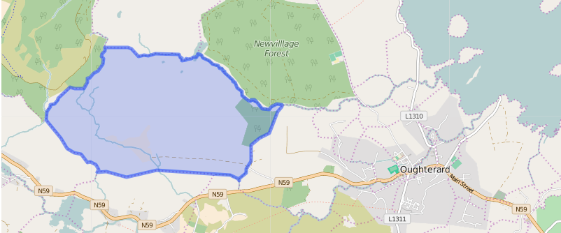
Lettercraff is in the civil parish of Kilcummin. The civil Parish corresponds with the following Church of Ireland parish of Kilcummin, Galway West. In general the civil parish and the Church of Ireland parish are the same as is the case in the Kilcummin Oughterard area.
It is a red heathy mountain, rocks and swamps. It contains 1,371¼ acres of land about 60 acres of which are under tillage, and 3 acres of water, the remainder is mountain pasture, two bye roads pass through the townland from East to West.
Lettercraff is in the Electoral Division of Oughterard, in Civil Parish of Kilcummin, in the Barony of Moycullen, in the County of Galway
Situation and Boundaries:
In the northern extremity of the parish.
Lettercraff borders the following other townlands:
- Ballynew to the east
- Barnagorteeny to the north
- Claremount to the east
- Derryerglinna to the west
- Glengowla East to the east
- Glengowla West to the south
- Letterfore to the west
Proprietor;
Irish Form of Name:
Leitir Cneamh
Translation:
Hillside of the wild garlic
Other Forms of the Name with the authority source (if provided) in italics
Lettercraff
Leitir Cneamh
Leitir cneamh
Lettercraff Boundary Surveyor
Letterknaff Barony Cess Book
Littercraw County Map
Lettercraff Local
Litterlugagh Mr. Griffiths Survey 1815
Litturlagagh Mr. Evans Survey 1760
Landlord:
Thomas B. Martin
of Ballynahinch Castle.
Thomas B. Martin is a member of the Martin (Ross) family.
Landlord: Thomas B. Martin
|
Information from the Down Survey Website:
The Down Survey is a mapped survey. Using the Civil Survey as a guide, teams of surveyors, mainly former soldiers, were sent out under Petty’s direction to measure every townland to be forfeited to soldiers and adventurers. The resulting maps, made at a scale of 40 perches to one inch (the modern equivalent of 1:50,000), were the first systematic mapping of a large area on such a scale attempted anywhere. The primary purpose of these maps was to record the boundaries of each townland and to calculate their areas with great precision. The maps are also rich in other detail showing churches, roads, rivers, castles, houses and fortifications. Most towns are represented pictorially and the cartouches, the decorative titles, of each map in many cases reflect a specific characteristic of each barony. (http://downsurvey.tcd.ie)
The Down Survey website will tell you who owned this townland in 1641 (pre Cromwell) and in 1671 (post Cromwell).
Townland of LETTERCRAFF
Down Survey Name: Littercalla
1641 Owner(s): French, Patrick (Catholic)
1670 Owner(s): Meredith, Sir Thomas (Protestant)
County: Galway
Barony: Muckullin
Parish: Killcumyn
Tithe Applotment Books:
About the Records
Tithes were a tax on agricultural produce which was payable by the occupiers of agricultural land. They were the main source of income for the parish clergy of the Church of Ireland (the largest Protestant church and the church established by law). However, in many parishes a large part of the tithes were ‘appropriate’, which meant that they were payable to a bishop, cathedral chapter or other ecclesiastical recipient, or were ‘impropriate’, which generally meant that they were payable to a local landowner. The parishes used in the Tithe Applotment Books are civil or Church of Ireland parishes, which often differ in name and territory from Catholic parishes, Acts of Parliament of 1823 and 1832 provided for the conversion of tithes into a fixed charge on land, and specified the average price of wheat or oats in the parish in the seven years before 1821 as the basis on which the tithes would be calculated. They also extended the application of tithes to pasture, where previously they had been levied only on tillage.
This change in the law resulted in the valuation of individual holdings in almost all parishes containing agricultural land, in order to assess the portion of the tithes for which each occupier of land would be liable. The apportionment was recorded for each Church of Ireland parish in a Tithe Composition Applotment Book. The information was collected and the amounts were calculated by two Parochial Commissioners, one of whom was appointed by the cess-payers of the parish and the other by the relevant Diocese of the Church of Ireland. This procedure was carried out in over 2,500 parishes between the years 1823 and 1837.
The Tithe Applotment Books are in a variety of formats, from a few pages sewn together to elaborately bound volumes. In most cases they are written in manuscript throughout, although some consist of manuscript entries on printed questionnaires. The information in the books is broadly uniform and generally includes at least the name of occupier; the size of holding, the valuation and the tithe payable. In some cases more detailed information is provided. Some volumes have maps and most have certificates and correspondence attached.
The sub-divisions of the parish were recorded. Some of these subdivisions, such as ploughlands, ceased to be in official use after the six inch survey of the Ordnance Survey was completed in the 1840s. Only productive land was subject to tithe, and the books usually distinguish between this tithable land and untithable land such as roads or mountains. Tithable land was in some cases classified by quality, and a money value was given to each class. In some cases the proportion of tithe payable to the rector, vicar or lay proprietor of the tithes was set out. The column for observations was sometimes completed, with information about commonage, for example.
There are a number of other points that should be noted. The acreages given in the Tithe Applotment Books are in Irish or Plantation measure, which is 1.62 times larger than statute measure. Only occupiers of land at the time of the tithe composition are recorded, so not all heads of households living in a parish at the time are included. Only rural areas are systematically covered, although inhabitants of towns who held plots of cultivable land are included. The equivalent tax in urban areas, Minister’s Money, has left few records.
The Tithe Applotment Books are an important source of information for a wide variety of researchers of pre-Famine Ireland. They provide the first surviving national list of the occupiers of land, and are used by genealogists as a partial substitute for returns of the 1821 and 1831 censuses of population, which were destroyed in 1922. They also record information on the quality of land, and provide information on pre-Ordnance Survey territorial divisions, some of which were not recognised after the 1840s.
The National Archives hold the original Tithe Applotment Books only for the twenty-six counties of the Republic of Ireland. The books for the six counties of Northern Ireland are held in the Public Record Office of Northern Ireland in Belfast. (http://titheapplotmentbooks.nationalarchives.ie/search/tab/aboutmore.jsp)
John Cooke, John Walker & John Mealy had 300 acres; 10 acres 2nd quality land with a payment of 1s, 10 acres 3rd quality land with a payment of 3d, 280 acres of 5th quality land with a payment of ⅛d. The Tithes payments went to Richard Martin Esq. James Daly & the Reverend John Wilson.
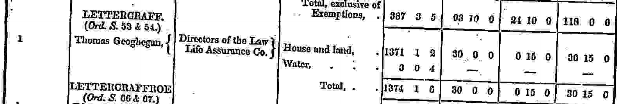
Griffiths Valuation 1850’s
In Griffith’s Valuation the area is 1371acres 1 rood 2perches while 3 acres and 4 perches was under water. The land value was £38 0s 0d. Value of Buildings is £0 15s 0d, and the total value is £30 15s 0d.
Occupiers of the Land: Thomas Geoghegan who had land and a house.
Landlord was The Directors of The Law Life Assurance co.
Ownership of Land and Property
Thomas Geoghegan owned a house and land.
http://www.askaboutireland.ie/griffith-valuation/index.xml?action=doNameSearch&PlaceID=560090
Census 1841-1891
1841 – 15 houses with 84 people
1851- 1 house with 10 people
1861 – 1 houses with 10 people
1871 – 1 house with No people
1881 – 2 houses with 6 people (1 males/5 females). 3 out buildings. Valuation of Land & Buildings £31 0s 0d.
1891 – 2 houses with 10 people (6 male/4 females). 4 out building. Valuation of Land & Buildings £31 0s 0d.
People who lived here:
You can retrieve a list of people who lived in this townland from 1827 to 1911. This list is compiled from the following resources.
- The Tithe Applotment Books
- Griffith’s Valuation
- 1901 Census
- 1911 Census
List of nineteenth century and early twentieth century inhabitants.
In general, the civil parish and the Church of Ireland parish are the same, but; this is not always the case.
Out Offices and Land
The out office was a farm building, a cow house, piggery or barn. The land was very poor and sterile and people were always poverty-stricken. At this time most tenants were trying to eke out a living on 5acres or less and a farmer needed at least 15.3 acres to survive.
Clachan: The Irish is ‘Clochán’. The houses in Lettercraff formed a Clachan. A clachan was a small traditional settlement common in Ireland until the middle of the 20th century. They usually lacked a church, post office or other formal building. The origin is unknown but it is likely that they are of ancient root most likely dating to medieval times.
The Lettercraff clachan was a cluster of small single storey farmers’ cottages built on poor land. They were related to the rundale system of farming. According to David Lloyd, The Great Famine 1845–1849 caused such disruption to the social system that the clachans virtually disappeared.
People living in Clachans had the support of a tight knit community.
In some cases the clachans have evolved into holiday villages or one or two houses have been taken over turning smaller houses into agricultural outhouses.
Poor Law Union Ireland
In Ireland the Poor Relief Act of 1838 divided into districts or “unions” in which the local taxable inhabitants were to be financially responsible for all paupers in the area. In 1898 the Poor Law Union was adopted as the basic administrative division in place of the civil parish and barony. Further subdivision into 828 registration districts and 3,751 district electoral divisions followed. Townlands were not arranged according to these divisions with parish and barony retained as a means to make comparisons with records gathered before 1898.
The 1838 Act
The main provisions of the 1838 Act were:
- The extension of the existing Poor Law Commissioners’ powers to Ireland, with the appointment of Assistant Commissioners who were to implement the Act in Ireland.
- The division of the country into Poor Law Unions based on Irish electoral divisions which were themselves made up from townlands.
- The creation of a Board of Guardians for each Union, two-thirds of whom were to be elected, the other third to be appointed ex officio.
- The setting up of a workhouse in each Union.
- The collection of a local poor-rate to finance the system.
- Assistance for emigration.
Initially, 130 Unions were created, based upon 2,049 electoral divisions. The divisions were composed of townlands, a peculiarly Irish unit, traditionally of 120 Irish acres in area. (Between 1848 and 1850, an additional 33 Unions were created by subdividing and reorganizing the boundaries of some existing Unions, particularly in the west of the country.
Boards of Guardians were elected annually on 25th March. Only rate-payers were eligible for election, which effectively disenfranchised most of the native Irish who were usually tenants at this time. Rate-payers were allowed between one and six votes depending on the size of a valuation of their property.
Townlands
A town land is one of the smallest land divisions in Ireland. They range in size from a few acres to thousands of acres. Many are Gaelic in origin, but some came into existence after the Norman invasion 1169. Lettercraff is a townland.
1901 Census Lettercraff
This is a return of the members of the family, their Visitors, Boarders and Servants who slept or abode in their house on the night of Sunday March 31st 1901 in Lettercraff.
Here were 2 houses listed in the Townland of Lettercraff. The people were all Roman Catholics and they were born in County Galway. There were 6 in total of farm buildings and out offices which included, stables, cow houses and piggeries.
Class of House: The class of house depended on the materials used in the roof, walls, number of rooms and number of front windows. A 1st class house was considered the highest standard.
Walls of the houses: The walls were of stone, brick, concrete or of mud, wood or other perishable material. The houses in Lettercraff were built of stone, brick or concrete. There were no mud cabins.
Roofs: Roofs were of slate, iron, tiles, thatch, wood or other perishable material. The roofs of houses were of thatch, wood or perishable material. Most likely they were thatched as there was ample reeds for thatching in the lakes.
House Occupancy: Each of the 2 houses was occupied by one family.
Enumerators Extract
http://www.census.nationalarchives.ie/reels/nai000840808/
House & Building Returns
http://www.census.nationalarchives.ie/reels/nai000840809/
Out Offices & Farm Steadings
http://www.census.nationalarchives.ie/reels/nai000840810/
The people listed as Head of the Family were also listed as the lawful Landholder of the property.
John Geoghegan aged 54 was head of the family. Living with him was his wife Bridget 48 and children Andrew 25, Bridget 24, Mary 20, Pat 17, Barbara 15 and Mark 8. John was a farmer who didn’t read or write but the rest of the family could. The family spoke Irish and English. The children were all single and their occupation was listed as sons and daughters of the farmer John. Barbara and Mark were scholars. They lived in a Class 3 house with 2 front windows. 8 persons occupied 3 available rooms. They had a stable, cow house and piggery.
House 2:
Mark Geoghegan head of the family aged 40, a farmer, lived with his wife Mary 25, his mother Ellen age 80 a widow who didn’t read and spoke only Irish, his sister Mary 32 and his young son Thomas 2 and baby Martin 4 months. Mark’s niece Mary Geoghegan aged 19 a domestic servant lived with them. The family spoke Irish and English. The family could read and write. They lived in a Class 2 house with 4 front windows. 7 persons occupied 4 available rooms. They had a stable, a cow house and piggery.
http://www.census.nationalarchives.ie/pages/1901/Galway/Oughterard/Lettercraff/1394697/
Lettercraff Census 1911
This is a return of the Members of families in Lettercraff, their visitors, boarders and servants who slept or abode in the house on the night of Sunday the 2nd of April 1911.
Description of the Houses
All the houses in Lettercraff were listed as private dwellings and were built of concrete or stone. The roofs of the houses were of wood, thatch or other perishable material. Most likely they were thatched. The head of the family were listed as the landholders. One family lived in each property. The Class of the house depended on the material used in the roof, walls, number of rooms and number of front windows. Most of the houses came under “2’ in the census form meaning that there could be 2, 3, or 4, rooms in the house.
Enumerators Extract
http://www.census.nationalarchives.ie/reels/nai002435679/
House & Building Returns
http://www.census.nationalarchives.ie/reels/nai002435681/
Out Offices & Farm Steadings
http://www.census.nationalarchives.ie/reels/nai002435683/
The two houses were private dwellings and they were Roman Catholics. There were 8 males and 6 females in the village
House 1:
John Geoghegan a farmer aged 70, lived with his wife Bridget 60 and their children Bridget 32, Andrew 30 and Mark 20. John and Bridget didn’t read or write but their children were literate. The family spoke Irish and English. They were 34 years married and 10 children were born alive and 7 were still living. The children living with them were single and their occupation was listed as farmer’s sons and daughter. They lived in a Class 2 house with 3 front windows. They had 2 stables, 2 cow houses and a piggery. 5 persons occupied 3 available rooms.
http://www.census.nationalarchives.ie/pages/1911/Galway/Oughterard/Lettercraff/471278/
House 2:
Ellen Geoghegan, a widow aged 96 was head of the family. Her son Mark 61 a farmer and his wife Mary and children Thomas 12, Martin 10, Mark 6, Barbara 4, Patrick 2 and Ellen’s daughter Mary Geoghegan aged 52 and single lived with the family. Ellen spoke Irish and didn’t read or write. Mark and Mary and their family could read and write and they spoke Irish and English. They were married 14 years with 6 children born alive and 5 still living. They lived in a Class 2 house with 4 front windows. They had a stable, cow house and a piggery. The family of 9 persons occupied 3 available rooms.
http://www.census.nationalarchives.ie/pages/1911/Galway/Oughterard/Lettercraff/471279/
Note: There is no evidence of the Kierlers, Kellys, Mc Graths, O’Malleys, Mac Keals, Lees or Cloherty’s in the 1901 or 1911 census.
Church records of births, deaths and marriages:
Church records of births, deaths and marriages are available online at http://www.rootsireland.ie. To search these records you will need to know the ‘church parish’ rather than the ‘civil parish’. (The civil parish is the pre-reformation parish and was frequently used as a unit of administration in the past.)
Lettercraff is in the civil parish of Kilcummin.
Catholic parish:
This civil parish corresponds with the following Roman Catholic parish or parishes.
- Clonbern & Kilkerrin in Galway East.
- Carraroe in Galway West.
- Kilannin in Galway West.
- Kilcummin/Oughterard in Galway West.
- Rosmuc in Galway West.
Church of Ireland parish:
This civil parish corresponds with the following Church of Ireland parish.
- Kilcummin in Galway West.
In general, the civil parish and the Church of Ireland parish are the same, but, this is not always the case.
Maps
It is located at 53° 26′ 8″ N, 9° 23′ 14″ W.
Original OS map of this area
Ireland was first mapped in the 1840s. These original maps are available online.
Original OS maps at the Ordnance Survey of Ireland website
Below is a link to the Ordnance Survey of Ireland website. It displays the original OS map that was created in the 1840s.
Information from Google Maps:
Information from the National Monuments Service:
Archaeological map from the National Monuments Service
Information from the Galway Library Website
http://places.galwaylibrary.ie/asp/fullresult.asp?id=52872
Townlands.ie Website
http://www.townlands.ie/galway/moycullen/kilcummin/oughterard-ed/lettercraff/
Deserted Village of Lettercraff ( Leitir Creamha)
The Geoghegan Ancestory
The late Jackie Geoghegan’s (Glengowla) family moved to a place called Lettercraff (Leitir Creamha) after the Great Famine in the mid nineteen century.
It is a beautiful valley a few miles long north west of the village of Oughterard. His great grandfather Tómas Geoghegan, married a woman from Leirtie Mór na Coille and built a house in the valley beside the Bunowen River. One of his sons John (Jackie’s grandfather), built his house a few feet from his parents home and most of his dwelling still stands today.
The Old Galway to Clifden Track
The track that runs through Lettercraff was the old Clifden Road where the “Pony Express” travelled all those years ago. As you head into the valley up to your right you can see the remains of some of the old houses that were deserted during famine times.
Lettercraff Families
There were up to twenty families living there. Kierlers, Kellys, Mc Graths, O Malleys, Mac Keals, Lees and the Clohertys. The Mac Keals owned a public house (Sibeen) on the old Connemara road. At a later stage it is believed that twenty-three other families immigrated to America from this village in one week.
Around the time of the famine one man, Martin Kelly began laying the outline for a house, which you can still see to this day.
New Clifden to Galway Road
I later visited a local man Pat Gibbons, who lives in Derrybeg, Maam Cross who told me he was involved in the laying of the present day Clifden Road. It was started back in the late 1920’s when the workers had to break the stones with small hammers and received 2 shillings and 6 pence for every tonne. The road was tarred in 1932.
The Demise of Lettercraff
Lettercraff is uninhabited now. The only sounds are those of the birds and the sheep who roam the mountainside through the few derelict houses where families once lived, but it is still a beautiful place where one can get lost in time.
“But dotted on the hillside green,
Small sad ruins may yet be seen,
Ivy covered stones still stand
Mute testimony of a ravished land.
And drills are clearly shown
The seed, that when full grown
provided food for our forebears,
‘Til dread famine stalked this land”. Imelda Brooks


Comments about this page
I am researching Thomas Evans my great grandfather married to Mary Jane Colvin 26th dec 1873 spiddal church of Ireland and son of Arthur Evans. I have very little information other than these details.
I have sent you some information by email
Add a comment about this page