Lackavrea
Text - Mary Kyne, Hyperlinks/Maps - Antoinette Lydon


Lackavrea is in the civil parish of Kilcummin. The civil Parish corresponds with the following Church of Ireland parish of Kilcummin, Galway West. In general, the civil parish and the Church of Ireland parish are the same as is the case in the Kilcummin Oughterard area.
The Irish form of the name is: Leac Aimréidhe
Translation: – rough flag
Civil Parish: Kilcummin View all place names in this civil parish.
Lackavrea is in the Electoral Division of Letterfore, in Civil Parish of Kilcummin, in the Barony of Moycullen, in the County of Galway
Other forms of name.
Lackavrea Leac Aimréidhe Leic aimhréidhe Lackavra Boundary Surveyor Leckavrea Barony Cess Book Leckamhra County Map Leckamrea, rugged rocky mountain Local Lacnavoran Mr. Griffiths Survey 1815 Lacnavara Mr. Evans Survey 1760
Comment: (is a remarkable mountain) Prond. Lack-av-ray
Description: A rugged and intricate rocky mountain. It contains 1,465½ acres of land. There is about 20 acres of arable and 190¼ acres of water, the remainder rugged mountain pasture. Lough Illaun forms part of the Southern boundary, also a large road the centre of which forms its Western boundary.
Situation: It is situated in the northern extremity of the parish. Bounded on the N. and E. by the parish of Ross and Lough Corrib, W. by Shannafola and S. by Lurgan, Derreennagusfur and Derryherbert townlands.
This is a list of townlands that share a border with this townland.
Some other placenames in or near this townland are…
- Carrow Rock (rock) – Ceathramha –a quarter – a barren rock situated N. of the townland of Lackavrea. There are several rocks on the S.E. and W. of the island. Situated in Lough Corrib but belongs to the townland of Lackavra.
- Cow Island (island) Contains ¾ chains of rough pasture, situated N. of Lackavrea townland and West of Roughillaun in Lough Corrib
- Falmore River (stream) Fál Mór – great ditch hedge or enclosure – a stream in the townland of Lackavrea and has its source in Loughanellaun and empties into Lough Corrib.
- Fish Island (rock) A barren rock situated N. of the townland of Lackavrea in Lough Corrib.
- Maamee Lough (lake) Mám Aodha – Hugh’s Maam or elevated pass – a considerable Lough of 681/4 acres with 4 small islands covered with brushwood. Situated on the boundary between Lackavrea and Shannafola townlands on the east side of the road heading from Butler’s Lodge to Maam.
- Roughillaun (island) red island. It contains3/4 acres of rough pasture situated N. of Lackavrea and E. of Cow Island in Lough Corrib but belongs to the townland of Lackavrea.
Landlord
Proprietor: Arthur French St. George
o St. George – Richard St George, a member of a Cambridgeshire family, came to Ireland in the 17th century and was appointed Governor of the town of Athlone. His grandson Richard St George of Carrick on Shannon, county Leitrim, had 2 natural children, Richard St George founder of the Hatley Manor, county Leitrim branch of the family and Mary St George, who married James Mansergh and they were the parents of Colonel Richard Mansergh St George of Headford, county Galway. Members of the family served as High Sheriffs of Leitrim in the eighteenth century. Charles Manners St. George and his Swedish wife Christina were the owners of the St. George estate in Leitrim in the mid-19th century. Petronella Halberg, niece of Christina St George, married Charles Whyte of Newtown Manor and the Whyte’s inherited Hatley Manor and much of the St George property. The representative of Mrs. St. George is listed as the owners of over 1600 acres in 1876. The family also held lands in counties Offaly, Roscommon, Tipperary (629 acres in the parish of Donaghmore, barony of Iffa and Offa East) and Waterford where Christina St George is recorded as the owner of over 1000 acres. Over 300 acres of Sir John St. George’s estate in the latter county was offered for sale in the Landed Estates Court in June 1878. Sir Richard St. George of Tully is recorded as a member of the Grand Panel of county Roscommon in 1828. In 1852 the Roscommon portion of the estate in the barony of Moycarn was offered for sale in the Encumbered Estates court. This was the property of Richard Bligh St. George and Thomas Baldwin St. George. However, it appears not to have all been sold as Kate St. George was a principal lessor in the parish of Moore, barony of Moycarn, at the time of Griffith’s Valuation. Her property was sublet from the Bishop of Meath. In the 1870s she is recorded as owning over 1700 acres in county Roscommon and was resident at Cheltenham, England.
o St. George (Tyrone House) – The St. George estate was centred on the house at Tyrone, parish of Drumacoo, barony of Dunkellin, built about 1779. This had originally been a French estate but the family assumed the title of St. George in 1774 due to inheritance from the St. George family of Hatley Manor, county Leitrim. In the 1830s A.F. St. George owned Tyrone House and Kilcolgan Castle, his agent was J. O’Hara. Wm. Griffith of Dublin also acted as an agent for the St. George estate. Arthur French St. George is described as a resident proprietor in 1824. In the early 19th century the St. Georges also owned large amounts of land in the baronies of Moycullen, Ballynahinch and Clare, which they advertised for sale in the early 1850s. Land in the barony of Clare had been acquired through Arthur French’s marriage with a Kirwan in the late 17th century. A portion of the St. George estate, situated in the barony of Longford, was offered for sale in the Encumbered Estates court in November 1853. In 1870s the family owned 15,777 acres in county Galway. By the early 1900s, however, some of the estate had been sold and the house at Tyrone had been left empty for long periods. In 1914 over 3000 acres of an estate described as St. George and Concannon was vested in the Congested Districts Board. Many members of the family are buried in a church-style mausoleum in the cemetery at Drumacoo.
Information from the Down Survey Website.
The Down Survey is a mapped survey. Using the Civil Survey as a guide, teams of surveyors, mainly former soldiers, were sent out under Petty’s direction to measure every townland to be forfeited to soldiers and adventurers. The resulting maps, made at a scale of 40 perches to one inch (the modern equivalent of 1: 50,000), were the first systematic mapping of a large area on such a scale attempted anywhere. The primary purpose of these maps was to record the boundaries of each townland and to calculate their areas with great precision. The maps are also rich in other detail showing churches, roads, rivers, castles, houses and fortifications. Most towns are represented pictorially and the cartouches, the decorative titles, of each map in many cases reflect a specific characteristic of each barony. (http://downsurvey.tcd.ie)
Townland of LACKAVREA
Down Survey Name: Leatry
1641 Owner(s): Lynch, Thomas (Catholic)
1670 Owner(s): Martin, Richard (Catholic)
County: Galway
Barony: Muckullin
Parish: Killcumyn
Unprofitable land: 15 plantation acres
Profitable land: 23 plantation acres
Forfeited: 23 plantation acres
The down survey website will tell you who owned this townland in 1641 (pre Cromwell) and in 1671 (post Cromwell).
Down Survey Website
The Tithe Applotment Books
About the Records
Tithes were a tax on agricultural produce which was payable by the occupiers of agricultural land. They were the main source of income for the parish clergy of the Church of Ireland (the largest Protestant church and the church established by law). However, in many parishes a large part of the tithes was ‘appropriate’, which meant that they were payable to a bishop, cathedral chapter or another ecclesiastical recipient, or were ‘impropriate’, which generally meant that they were payable to a local landowner. The parishes used in the Tithe Applotment Books are civil or Church of Ireland parishes, which often differ in name and territory from Catholic parishes, Acts of Parliament of 1823 and 1832 provided for the conversion of tithes into a fixed charge on land, and specified the average price of wheat or oats in the parish in the seven years before 1821 as the basis on which the tithes would be calculated. They also extended the application of tithes to pasture, where previously they had been levied only on tillage.
This change in the law resulted in the valuation of individual holdings in almost all parishes containing agricultural land, in order to assess the portion of the tithes for which each occupier of land would be liable. The apportionment was recorded for each Church of Ireland parish in a Tithe Composition Applotment Book. The information was collected and the amounts were calculated by two Parochial Commissioners, one of whom was appointed by the cess-payers of the parish and the other by the relevant Diocese of the Church of Ireland. This procedure was carried out in over 2,500 parishes between the years 1823 and 1837.
The Tithe Applotment Books are in a variety of formats, from a few pages sewn together to elaborately bound volumes. In most cases they are written in manuscript throughout, although some consist of manuscript entries on printed questionnaires. The information in the books is broadly uniform and generally includes at least the name of occupier; the size of holding, the valuation and the tithe payable. In some cases, more detailed information is provided. Some volumes have maps and most have certificates and correspondence attached.
The sub-divisions of the parish were recorded. Some of these subdivisions, such as plough lands, ceased to be in official use after the six-inch survey of the Ordnance Survey was completed in the 1840s. Only productive land was subject to tithe, and the books usually distinguish between this tithable land and untithable land such as roads or mountains. Tithable land was in some cases classified by quality, and a money value was given to each class. In some cases, the proportion of tithe payable to the rector, vicar or lay proprietor of the tithes was set out. The column for observations was sometimes completed, with information about commonage, for example.
There are a number of other points that should be noted. The acreages given in the Tithe Applotment Books are in Irish or Plantation measure, which is 1.62 times larger than statute measure. Only occupiers of land at the time of the tithe composition are recorded, so not all heads of households living in a parish at the time are included. Only rural areas are systematically covered, although inhabitants of towns who held plots of cultivable land are included. The equivalent tax in urban areas, Minister’s Money, has left few records.
The Tithe Applotment Books are an important source of information for a wide variety of researchers of pre-Famine Ireland. They provide the first surviving national list of the occupiers of land, and are used by genealogists as a partial substitute for returns of the 1821 and 1831 censuses of population, which were destroyed in 1922. They also record information on the quality of land, and provide information on pre-Ordnance Survey territorial divisions, some of which were not recognized after the 1840s.
The National Archives hold the original Tithe Applotment Books only for the twenty-six counties of the Republic of Ireland. The books for the six counties of Northern Ireland are held in the Public Record Office of Northern Ireland in Belfast. (http://titheapplotmentbooks.nationalarchives.ie/search/tab/aboutmore.jsp)
No information available.
Griffiths Valuation 1850’s
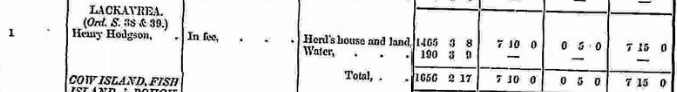
In Griffith’s Valuation the area is 1465acres 3rood 8 perches with a land value of £7 10s 0d. Value of Buildings is 5s 0d, and the total value is £7 15s 0d. Water 190 acres 3 rood 9perches
Occupiers of the Land: Henry Hodgson was listed as occupier and immediate lessor.
http://www.askaboutireland.ie/griffith-valuation/index.xml?action=doNameSearch&PlaceID=559073
View the heads of households in the townland at this time.
Landlord
o Hodgson – The Hodgson family came to Ireland from Whitehaven in Cumberland, England and were mine owners in Avoca, county Wicklow before they moved west in the mid-19th century. Pádraig Lane writes that they spent over £22,000 buying 2,800 acres in the Galway area from George F. O’Flahertie, Robert H. Eyre, William H. Gregory, Charles Blake, the Reverend T. Kelly and Christopher St. George. They mined copper and lead on their estate in the west of Ireland, which was mainly located in the parish of Kilcummin, barony of Moycullen, county Galway. By the time of Griffith’s Valuation, they held eleven townlands in the parish, some of which had previously belonged to the St George family. In 1852 Henry Hodgson bought Merlin Park from the sale of the estate of Charles Blake in the Encumbered Estates’ Court. The Merlin Park estate of 1,109 acres, including the marble quarries at Dohiskey, and some land at Castle Waller (321 acres) in county Tipperary, were advertised for sale in the Landed Estates’ Court in 1868 but it was not until 1876 that the Waithmans bought the Merlin Park estate. Henry Hodgson still owned over 17,000 acres in county Galway in the early 1870s. http://www.currarevagh.com/
Ownership of Land and Property
Henry Hodgson owned land, water and a herd’s house.
Out Offices and Land
The out office was a farm building, a cow house, piggery or barn. The land was very poor and sterile and people were always poverty-stricken. At this time most tenants were trying to eke out a living on 5acres or less and a farmers needed at least 15.3 acres to survive.
Poor Law Union Ireland
In Ireland the Poor Relief Act of 1838 divided into districts or “unions” in which the local taxable inhabitants were to be financially responsible for all paupers in the area. In 1898 the Poor Law Union was adopted as the basic administrative division in place of the civil parish and barony. Further subdivision into 828 registration districts and 3,751 district electoral divisions followed. Townlands were not arranged according to these divisions with parish and barony retained as a means to make comparisons with records gathered before 1898.
The 1838 Act
The main provisions of the 1838 Act were:
- The extension of the existing Poor Law Commissioners’ powers to Ireland, with the appointment of Assistant Commissioners who were to implement the Act in Ireland.
- The division of the country into Poor Law Unions based on Irish electoral divisions which were themselves made up from townlands.
- The creation of a Board of Guardians for each Union, two-thirds of whom were to be elected, the other third to be appointed ex officio.
- The setting up of a workhouse in each Union.
- The collection of a local poor-rate to finance the system.
- Assistance for emigration.
Initially, 130 Unions were created, based upon 2,049 electoral divisions. The divisions were composed of townlands, a peculiarly Irish unit, traditionally of 120 Irish acres in area. (Between 1848 and 1850, an additional 33 Unions were created by subdividing and reorganizing the boundaries of some existing Unions, particularly in the west of the country.
Boards of Guardians were elected annually on 25th March. Only rate-payers were eligible for election, which effectively disenfranchised most of the native Irish who were usually tenants at this time. Rate-payers were allowed between one and six votes depending on the size of a valuation of their property.
Townlands
A town land is one of the smallest land divisions in Ireland. They range in size from a few acres to thousands of acres. Many are Gaelic in origin, but some came into existence after the Norman invasion 1169. Lackavrea is a townland.
Population & Census Information
People who lived here:
You can retrieve a list of people who lived in this townland from 1827 to 1911. This list is compiled from the following resources.
- The Tithe Applotment Books
- Griffith’s Valuation
- 1901 Census
- 1911 Census
List of nineteenth century and early twentieth century inhabitants of this townland.
1841-1891 Census
1841 – 2 houses with 9 people
1851 – No one living in the townland
1861 – 2 houses with 8 people
1871 – 2 houses with 12 people
1881 – 2 houses (1 inhabited) with 7 people (4 males, 3 females). There was 1 outbuilding.
The valuation of Houses & Land in 1881 was £8 0s 0d.
1891 – 1 house (1 inhabited) with 5 people (3 males, 2 females). There were 5 outbuildings.
The valuation of Houses & Land in 1891 was £8 0s 0d.
Census Lackavrea 1901
This is a return of the members of the Barrett family who slept or abode in their house on the night of Sunday March 31st 1901 in Lackavrea
There was 1 house listed in the Townland of Lackavrea. The people were all Roman Catholics and they were born in County Galway. There were 3 in total of farm buildings and out offices which included a cow house and piggery.
Class of House: The class of house depended on the materials used in the roof, walls, number of rooms and number of front windows. A 1st class house was considered the highest standard.
Walls of the houses: The walls were of stone, brick, concrete or of mud, wood or other perishable material. The house in Lackavrea was built of stone, brick or concrete. It was not a mud cabin.
Landholder of the property was Harry Hodgson. The roof was of slate, iron, tiles, thatch, wood or other perishable material. It was most likely thatched as there were ample reeds for thatching in the lakes.
House Occupancy: One family occupied the private dwelling.
Enumerators Extract
http://www.census.nationalarchives.ie/reels/nai000840395/
House & Building Return
http://www.census.nationalarchives.ie/reels/nai000840396/
Out Office & Farm Steading
http://www.census.nationalarchives.ie/reels/nai000840397/
House 1: Thomas Barrett head of the family a shepherd aged 68 lived with his wife Mary 62 and their son Thomas 25 who was single and listed as a shepherd’s son. They didn’t read or write but they spoke Irish and English. They lived in a Class 3 house with 2 front windows. 3 persons occupied 3 available rooms. They had a cow house and a piggery.
http://www.census.nationalarchives.ie/pages/1901/Galway/Letterfore/Lackavrea/1394495/
Lackavrea Census 1911
This is a return of the Members of the Barrett Family in Lackavrea, their visitors, boarders and servants who slept or abode in the house on the night of Sunday the 2nd of April 1911.
Description of the Houses
The house in Lackavrea was listed as private dwelling and was built of concrete or stone. The roof of the house was of wood, thatch or other perishable material. Most likely it was thatched. One family lived in the property. The Class of the house depended on the material used in the roof, walls, number of rooms and number of front windows. Most houses in the area came under “2’ in the census form meaning that there could be 2, 3, or 4, rooms in the house.
Enumerators Extract http://www.census.nationalarchives.ie/reels/nai002434988/
House & Building Return
http://www.census.nationalarchives.ie/reels/nai002434990/
Out Office & Farm Steading
http://www.census.nationalarchives.ie/reels/nai002434992/
House1; Thomas Barrett head of the family aged 33 was a herdsman who lived with his wife Julia aged 31 and their children Patrick 6, Mary 4, John 2 and Thomas 1. They didn’t read or write but they spoke Irish and English. They lived in a Class 3 house with 2 front windows. They were married 7 years and 4 children were born alive and 4 were still living. They had 2 cow houses. 6 persons occupied 1 available room. Henry Hodgson was the lawful landowner.
http://www.census.nationalarchives.ie/pages/1911/Galway/Letterfore/Lackavrea/912191/
Church records of births, deaths and marriages:
Church records of births, deaths and marriages are available online at http://www.rootsireland.ie. To search these records, you will need to know the ‘church parish’ rather than the ‘civil parish’. (The civil parish is the pre-reformation parish and was frequently used as a unit of administration in the past.)
Lackavrea is in the civil parish of Kilcummin.
Roman Catholic parishes:
This civil parish corresponds with the following Roman Catholic parish or parishes.
- Carraroe
- Kilannin
- Kilcummin/Oughterard
- Rosmuc
Church of Ireland parishes:
This civil parish corresponds with the following Church of Ireland parish.
- Kilcummin
In general, the civil parish and the Church of Ireland parish are the same, but, this is not always the case.
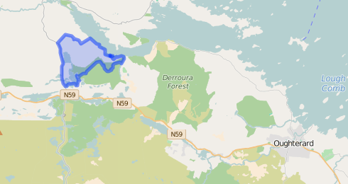
Map
It is located at 53° 28′ 36″ N, 9° 31′ 35″ W.
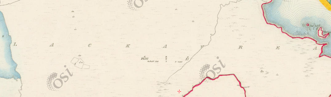
Original OS map of this area.
Ireland was first mapped in the 1840s. These original maps are available online.
Original OS maps at the Ordnance Survey of Ireland website. Below is a link to the Ordnance Survey of Ireland website. It displays the original OS map that was created in the 1840s. Lackavrea
Information from Google Maps. You can use this link to find this townland on Google Maps.
Information from the National Monuments Service. You can use this link to view a map of archaeological features. This link brings you to a website wherein you will have to search for your townland.
Archaeological map from the National Monuments Service
Galway Library Website
http://places.galwaylibrary.ie/place/52837
Townlands.ie Website
https://www.townlands.ie/galway/moycullen/kilcummin/letterfore/lackavrea/


Comments about this page
Regarding query by Sandra Heaney, this information should be available in the Cancelled Books of the Irish Land Valuations at Block 2 , Irish Life Building, Lower Abbey Street, Dublin 1. Near Luas Stop
http://www.valoff.ie – Email info@valoff.ie – Tel. 353 1 8171000
Regards,
Im trying to find out in what year did the Barrett family aquire ownership of this land off Henry hodgson? Can someone help?
Add a comment about this page