Derroogh North
Antoinette Lydon


Derroogh North is in the civil parish of Kilcummin. The civil Parish corresponds with the following Church of Ireland parish of Kilcummin, Galway West. In general, the civil parish and the Church of Ireland parish are the same as is the case in the Kilcummin Oughterard area.
Derroogh North is in the Electoral Division of Turlough, in Civil Parish of Kilcummin, in the Barony of Moycullen, in the County of Galway
Information from O’Donovan’s Field Name Books
Irish Form of Name: Doireadh mhagh
Translation: oak plain
Parish: Kilcummin
View all place names in this civil parish.
Other Forms of the Name with the authority source (if provided) in italics.
Derroogh
Doireadh mhagh
Derroo
Derroogh North Boundary Surveyor
Derraght County Map
Derroogh North Local
Derraght Barony Map
Comment:
Doireadh, prond. as if Doir-Mhagh
This is a list of townlands that share a border with this townland.
Other placenames in this townland:
- Derroughter (trigonometrical station)
- Keeraunaderroogh (hill)
Description:
Derroogh North contains 1,143¾ acres of land all mountain bog except about 40 acres of tillage and pasture. A bye road passes through its centre. It also contains 88½ acres of water.
Landlord: James Blake of Tullagh
Information on the owner’s family from the Landed Estates Database
James Blake is a member of the Blake (Drum, Tully and Gortnamona) family.
- Blake (Drum, Tully & Gortnamona)– In his genealogy of the Blakes of Drum, Tully and Gortnamona, Martin J. Blake refers to a grant dated 22 Aug 1677 of the lands of Drum and others in the barony of Moycullen, county Galway, to Walter Blake. A descendant, Patrick Blake of Drum, was Mayor of Galway in 1771 and his eldest son, Valentine, married Anne Burke of Gortnamona, near Ballinasloe. About 500 acres belonging to the Blakes, devisees of Nicholas A. Burke, in the baronies of Leitrim, Longford and Clonmacnowen, were advertised for sale in July 1853. This family of Blakes owned a large estate in the parishes of Killannin, Kilcummin and Moycullen, barony of Moycullen, county Galway, at the time of Griffith’s Valuation. In the 1870s Valentine [Fitzpatrick] Blake of Gortnamona is recorded as the owner of 17,335 acres in county Galway though Walford notes that he had died in 1870 and his son, Valentine Blake, born in 1868, was a Ward in Chancery.
Information from the Down Survey Website:
The Down Survey is a mapped survey. Using the Civil Survey as a guide, teams of surveyors, mainly former soldiers, were sent out under Petty’s direction to measure every townland to be forfeited to soldiers and adventurers. The resulting maps, made at a scale of 40 perches to one inch (the modern equivalent of 1:50,000), were the first systematic mapping of a large area on such a scale attempted anywhere. The primary purpose of these maps was to record the boundaries of each townland and to calculate their areas with great precision. The maps are also rich in other detail showing churches, roads, rivers, castles, houses and fortifications. Most towns are represented pictorially and the cartouches, the decorative titles, of each map in many cases reflect a specific characteristic of each barony. (http://downsurvey.tcd.ie)
The Down Survey website will tell you who owned this townland in 1641 (pre Cromwell) and in 1671 (post Cromwell).
Townland of DERROOGH NORTH
Down Survey Name: Derrimore
1641 Owner(s): O’Flahartye, Syralagh (Catholic)
1670 Owner(s): Meredith, Sir Thomas (Protestant)
County: Galway
Barony: Muckullin
Parish: Killcumyn
The Tithe Applotment Books
About the Records
Tithes were a tax on agricultural produce which was payable by the occupiers of agricultural land. They were the main source of income for the parish clergy of the Church of Ireland (the largest Protestant church and the church established by law). However, in many parishes a large part of the tithes were ‘appropriate’, which meant that they were payable to a bishop, cathedral chapter or other ecclesiastical recipient, or were ‘impropriate’, which generally meant that they were payable to a local landowner. The parishes used in the Tithe Applotment Books are civil or Church of Ireland parishes, which often differ in name and territory from Catholic parishes, Acts of Parliament of 1823 and 1832 provided for the conversion of tithes into a fixed charge on land, and specified the average price of wheat or oats in the parish in the seven years before 1821 as the basis on which the tithes would be calculated. They also extended the application of tithes to pasture, where previously they had been levied only on tillage.
This change in the law resulted in the valuation of individual holdings in almost all parishes containing agricultural land, in order to assess the portion of the tithes for which each occupier of land would be liable. The apportionment was recorded for each Church of Ireland parish in a Tithe Composition Applotment Book. The information was collected and the amounts were calculated by two Parochial Commissioners, one of whom was appointed by the cess-payers of the parish and the other by the relevant Diocese of the Church of Ireland. This procedure was carried out in over 2,500 parishes between the years 1823 and 1837.
The Tithe Applotment Books are in a variety of formats, from a few pages sewn together to elaborately bound volumes. In most cases they are written in manuscript throughout, although some consist of manuscript entries on printed questionnaires. The information in the books is broadly uniform and generally includes at least the name of occupier; the size of holding, the valuation and the tithe payable. In some cases more detailed information is provided. Some volumes have maps and most have certificates and correspondence attached.
The sub-divisions of the parish were recorded. Some of these subdivisions, such as ploughlands, ceased to be in official use after the six inch survey of the Ordnance Survey was completed in the 1840s. Only productive land was subject to tithe, and the books usually distinguish between this tithable land and untithable land such as roads or mountains. Tithable land was in some cases classified by quality, and a money value was given to each class. In some cases the proportion of tithe payable to the rector, vicar or lay proprietor of the tithes was set out. The column for observations was sometimes completed, with information about commonage, for example.
There are a number of other points that should be noted. The acreages given in the Tithe Applotment Books are in Irish or Plantation measure, which is 1.62 times larger than statute measure. Only occupiers of land at the time of the tithe composition are recorded, so not all heads of households living in a parish at the time are included. Only rural areas are systematically covered, although inhabitants of towns who held plots of cultivable land are included. The equivalent tax in urban areas, Minister’s Money, has left few records.
The Tithe Applotment Books are an important source of information for a wide variety of researchers of pre-Famine Ireland. They provide the first surviving national list of the occupiers of land, and are used by genealogists as a partial substitute for returns of the 1821 and 1831 censuses of population, which were destroyed in 1922. They also record information on the quality of land, and provide information on pre-Ordnance Survey territorial divisions, some of which were not recognised after the 1840s.
The National Archives hold the original Tithe Applotment Books only for the twenty-six counties of the Republic of Ireland. The books for the six counties of Northern Ireland are held in the Public Record Office of Northern Ireland in Belfast. (http://titheapplotmentbooks.nationalarchives.ie/search/tab/aboutmore.jsp)
No information in The Tithe Applotment Books for Derroogh North.
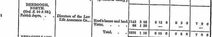
Griffith’s Valuation
Area: Land & Buildings – 1143 acres 3 rood 26 perches. Water 88 acres 1 rood 30 perches
In Griffith’s Valuation the land value is £6 15s 0d. The value of the buildings is £0 5s 0d. Total Valuation £7 0s 0d.
Occupiers of the Land: Patrick Joyce.
Immediate Lessor: The Directors of the Law life company.
http://www.askaboutireland.ie/griffith-valuation/index.xml?action=doNameSearch&PlaceID=560328
Poor Law Union Ireland
In Ireland the Poor Relief Act of 1838 divided into districts or “unions” in which the local taxable inhabitants were to be financially responsible for all paupers in the area. In 1898 the Poor Law Union was adopted as the basic administrative division in place of the civil parish and barony. Further subdivision into 828 registration districts and 3,751 district electoral divisions followed. Townlands were not arranged according to these divisions with parish and barony retained as a means to make comparisons with records gathered before 1898.
The 1838 Act
The main provisions of the 1838 Act were:
- The extension of the existing Poor Law Commissioners’ powers to Ireland, with the appointment of Assistant Commissioners who were to implement the Act in Ireland.
- The division of the country into Poor Law Unions based on Irish electoral divisions which were themselves made up from townlands.
- The creation of a Board of Guardians for each Union, two-thirds of whom were to be elected, the other third to be appointed ex officio.
- The setting up of a workhouse in each Union.
- The collection of a local poor-rate to finance the system.
- Assistance for emigration.
Initially, 130 Unions were created, based upon 2,049 electoral divisions. The divisions were composed of town lands, a peculiarly Irish unit, traditionally of 120 Irish acres in area. (Between 1848 and 1850, an additional 33 Unions were created by subdividing and reorganizing the boundaries of some existing Unions, particularly in the west of the country.
Boards of Guardians were elected annually on 25th March. Only rate-payers were eligible for election, which effectively disenfranchised most of the native Irish who were usually tenants at this time. Rate-payers were allowed between one and six votes depending on the size of a valuation of their property.
Out Offices and Land
The out office was a farm building, a cow house, piggery or barn. The land was very poor and sterile and people were always poverty-stricken. At this time most tenants were trying to eke out a living on 5 acres or less and a farmer needed at least 15.3 acres to survive.
What is a townland?
A townland is one of the smallest land divisions in Ireland. They range in size from a few acres to thousands of acres. Many are Gaelic in origin, but some came into existence after the Norman invasion of 1169. Derroogh North is a townland.
Population & Census Information:
You can retrieve a list of people who lived in this townland from 1827 to 1911. This list is compiled from the following resources.
- The Tithe Applotment Books
- Griffith’s Valuation
- 1901 Census
- 1911 Census
List of nineteenth century and early twentieth century inhabitants.
1841-1891 Census
1841 – 1 house with 3 people
1851 – 1 house with 10 people
1861 – 1 house with 6 people
1871 – 1 house with 8 people
1881 – 1 house with 6 people (3 males/3 females). There was 1 outbuilding. Total Valuation of Houses & Lands £7 0s 0d.
1891 – 3 houses with 17 people (7 males/10 females). There was 3 Outbuildings. Total Valuation of Houses & Lands £7 0s 0d.
1841/1851 Old Age Pension Census Search Forms
An application was made by Costello from Deroogh in the Parish of Kilcummin in the Barony of Moycullen. Reference # Cen/S/2001. The surname Folan also appears on the application. Record was found for 1851.
An application was made by Costello from Deroogh in the Parish of Kilcummin in the Barony of Moycullen. Reference # Cen/S/2002. Record was found, no year indicated.
An application was made by Julia Costello. Address: Mrs Julia Folan, Laughmore, Spiddal, Co. Galway
Full Names of Father and Mother of the applicant: Mich & Maria Costello (Folan)
Residence in 1851: Townland: Derroogh N/S Parish: Kilcummin, Barony: Moycullen, County: Galway
The following names were found on the application: Mary 6, Julia 4, Mathew 1, Bridget, Nora, John, Bartly, Sarah & Michael.
Date of receipt: 11.10.21 Reference: CenS/11/2001 Application No. C/21 6385
Return searched by FW 12/10/21 Mich & Sally Costello md – 1840 Mary 6yrs, Judy 4 yrs, Mathew 1 year
Sheet 2 Mich & Mary Costello md – 1857 no children sheet 15
Other information (see attached application form)
Copy dispatched 26/10/21 3/- written on top right corner of application
1901 Census
This is a return of the members of the family, visitors, boarders or servants who slept or abode in their house on the night of Sunday March 31st 1901 in Derroogh North.
There was 1 house listed in the Townland of Derroogh North. The people were all Roman Catholics and they were born in County Galway. There were 2 males and 2 females in the townland and they all lived in a private dwelling. There were 3 in total of farm buildings and out offices which included, 2 cow houses a stable.
Enumerators Extract
http://www.census.nationalarchives.ie/reels/nai000839810/
House & Building Returns
http://www.census.nationalarchives.ie/reels/nai000839811/
Out Offices & Farm Steadings
http://www.census.nationalarchives.ie/reels/nai000839812/
House 1
Thomas Nee aged 28 was head of the family, married to Nora aged 20. They lived with their son Patrick aged 8 months & visitor Bridgie Keane aged 12.
Thomas was a herd; Nora was a housekeeper & Bridgie was a scholar. Thomas & Patrick could not read or write; Nora & Bridgie could read & write. Thomas, Nora & Bridgie spoke Irish & English.
They lived in a 3rd class house with 2 rooms and 2 front windows. They had a stable & 2 cow houses. This was a private dwelling. Thomas Francis Joyce was the landlord.
http://www.census.nationalarchives.ie/pages/1901/Galway/Turlough/Derroogh_North/1394094
1911 Census
There is no record of anyone living in Derroogh North in 1911.
http://www.census.nationalarchives.ie/pages/1911/Galway/Turlough/
Church records of births, deaths and marriages are available online at http://www.rootsireland.ie. To search these records, you will need to know the ‘church parish’ rather than the ‘civil parish’. (The civil parish is the pre-reformation parish and was frequently used as a unit of administration in the past.)
Derroogh North is in the civil parish of Kilcummin.
Catholic parish:
This civil parish corresponds with the following Roman Catholic parish or parishes.
- Clonbern & Kilkerrin in Galway East.
- Carraroe in Galway West.
- Kilannin in Galway West.
- Kilcummin/Oughterard in Galway West.
- Rosmuc in Galway West.
Church of Ireland parish:
This civil parish corresponds with the following Church of Ireland parish.
- Kilcummin in Galway West.
In general, the civil parish and the Church of Ireland parish are the same, but, this is not always the case.
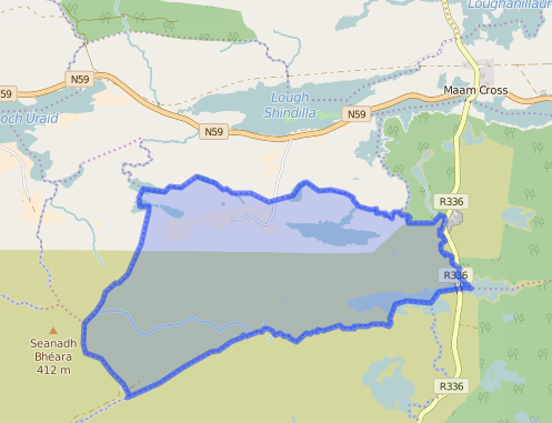
Maps
It is located at 53° 26′ 19″ N, 9° 34′ 28″ W.
Derroogh North is on Logainm.ie: Derroogh North
Original OS map of this area
Ireland was first mapped in the 1840s. These original maps are available online.
Original OS maps at the Ordnance Survey of Ireland website
Below is a link to the Ordnance Survey of Ireland website. It displays the original OS map that was created in the 1840s.
Information from Google Maps:
You can use this link to find this townland on Google Maps.
Information from the National Monuments Service:
You can use this link to view a map of archaeological features. This link brings you to a website wherein you will have to search for your townland.
Archaeological map from the National Monuments Service
Galway Library Website
http://places.galwaylibrary.ie/asp/fullresult.asp?id=52275
Townlands.ie Website
https://www.townlands.ie/galway/moycullen/kilcummin/turlough/derroogh-north/
Tim Robinson’s townland index for Connemara and the Aran Islands
https://digital.library.nuigalway.ie/islandora/object/nuigalway%3A2740


No Comments
Add a comment about this page