Derravonniff
Antoinette Lydon


Derravonniff is in the civil parish of Kilcummin. The civil parish corresponds with the following Church of Ireland parish of Kilcummin, Galway West. In general, the civil parish and the Church of Ireland parish are the same as is the case in the Kilcummin Oughterard area.
Derravonniff is in the Electoral Division of Camus, in Civil Parish of Kilcummin, in the Barony of Moycullen, in the County of Galway
Irish Form of Name: Doire Dhá Bhanbh
Civil Parish: Kilcummin View all place names in this civil parish.
Information from O’Donovan’s Field Name Books
Other Forms of the Name with authority source (if provided) in italics:
Derravonniff [changed from Derrauvonniff – u crossed out]
Doire Dhá Bhanbh Doire dhá bhanbh
Derravanniff Barony Cess Book
Derraoonniv Boundary Surveyor
Derrywinniff County Map
Derravonnif Local
Description:
The land in Derravonniff is very bad and swampy. Contains 1,049¼ acres of land all mountain pasture, except about 20 acres of rocky tillage and 52½ acres of water, two roads pass through this townland.
Situation:
In the south western part of the parish, bounded on the N. by Cruckadaav, on the West by Glancoho, on the South by Camus Ooghter.
This is a list of townlands that share a border with this townland.
Some other placenames in or near this townland are…
- Bealnacurra (island)
- Belion Island stet. (island)
- Bunnahowna (rock)
- Burned Island (island)
- Cabbage Island (island)
- Carnagh Island (island)
- Carrickillaunnascalp (island)
- Heath Island (island)
- Illaunatuic (rock)
- Illaunnaginga (rock)
- Illaunnascalp (island)
- Loughaunweeny (lake)
- Loughknockaunawaddy (lake)
- Onnia Island (island)
- Otter Rock (rock)
- Potatoe Island (island)
- Rush Island (island)
- Rusheen Rock (rock)
- Screeb Bridge (bridge)
- Sheeaun Island (island)
Proprietor
Nicholas Lynch of Barna House
Information on the owner’s family from the Landed Estates Database;
Nicholas Lynch is a member of the Lynch (Barna) family.
Information from Joyce’s Place Names
Translation according to P. W. Joyce:
Derravonniff in Galway; Doire-dha-bhanbh [Der-aw-vonniff], oak wood of the two bonnivs or sucking-pigs. For two objects in names, see vol. i. p. 247 [reproduced below].
I never saw it stated that the number two was in Ireland considered more remarkable than any other; but from whatever cause it may have arisen, certain it is that there existed in the minds of the Irish people a distinctly marked predilection to designate persons or places, where circumstances permitted it, by epithets expressive of the idea of duality, the epithet being founded on some circumstance connected with the object named; and such circumstances were often seized upon to form a name in preference to others equally or more conspicuous. We have, of course, as they have in all countries, names with combinations of other numbers, and those containing the number three are very numerous; but the number two is met with many times more frequently than all the others put together. The Irish word for two that occurs in names is dá or dhá, both forms being used; dá is pronounced daw; but in the other form, dh, which has a peculiar and rather faint guttural sound, is altogether suppressed in modern names; the word dhá being generally represented by the vowel a, while in many cases modern contraction has obliterated every trace of a representatibe letter. It is necessary to bear in mind that dá or dhá generally causes aspiration, and in a few cases eclipses consonants and prefixes n to vowels (see pp. 19 and 21, supra). We find names involving the number two recorded in Irish history, from the most ancient authorities down to the MSS. of the seventeenth century, and they occur in proportion quite as numerously as at the present day; showing that this curious tendency is not of modern origin, but that it has descended, silent and unnoticed, from ages of the most remote antiquity. There is a village and parish in the north-west of Tipperary, on the shore of Lough Derg, now called Terryglass: its Irish name, as used in many Irish authorities, is Tir-da-ghlas, the territory of the two streams; and the identity of this with the modern Terryglass is placed beyond all doubt by a passage in the “Life of St. Fintan of Clonenagh”, which describes Tir-da-glas as “in the territory of Munster, near the River Shannon”. The great antiquity of this name is proved by the fact that it is mentioned by Adamnan in his “Life of St. Columba” (Lib. Ii., Cap. XXXVI.), written in the end of the seventh century; but according to his usual custom, instead of the Irish name, he gives the Latin equivalent: in the heading of the chapter it is called Ager duorum rivorum, and in the text Rus duum riculorum, either of which is a correct translation of Tir-da-ghlas. There is a subdivision of the townland of Clogher in the parish of Kilnoe, Clare, called Terryglass, which has the same Irish form and meaning as the other. In the Book of Leinster there is a short poem, ascribed to Finn Mac Cumhail, accounting for the name of Magh-da-ghéisí, in Leinster, the plain of the two swans; and the Dinnsenchus gives a legend about the name of the river Owendalulagh, which rises on the slope of Slieve Aughty, and flows into Lough Cooter near Gort in Galway. This legend states, that when Echghe [Ekte] a Dedannan lady, married Fergus Lusca, cup-bearer to the king of Connaught, she brought with her two cows, remarkable for their milk-bearing fruitfulness, which were put to graze on the banks of this stream; and from this cricumstance it was called Abhainn-da-loilgheach, the river of the two milch cows. According to the same authority, Slieve Aughty took its name from this lady – Sliabh-Echtghe, Echtghe’s mountain. Several other instances of names of this class, mentioned in ancient authorities, will be cited as I proceed. This word loilgheach appears in the name of a lake in the north of Armagh, near the south-west corner of Lough Neagh, called Derrylileagh, which means the derry or oak-grove of the milch cows. Though this peculiarity is not so common in personal as in local names, yet the number of persons mentioned in Irish writings whose names involve the number two, is sufficiently large to be very remarkable. The greater number of these names appear to be agnomina, which described certain peculiarities of the individuals, and which were imposed for the sake of distinction, after a fashion prevalent among most nations before the institution of surnames. (See Vol. II., Ch. IX.). One of the three Collas who conquered Ulster in the fourth century (see p. 137) was called Colla-da-Chrich, Colla of the two territories. Da-chrich was a favourable sobriquet and no doubt, in case of each individual, it records the fact of his connection, either by possession or residence, with two countries or districts; in case of Colla, it most probably refers to two territories in Ireland and Scotland, in the latter of which he lived some years in a state of banishment before his invasion of Ulster. In the Martyrology of Donegal there are nine different persons mentioned, called Fer-da-chrich, the man of the two territories. The word Dubh applied to a dark-visaged person is often followed by da; thus the Four Masters mention two persons named Dubh-da-bharc, the black (man) of the two ships; four, named Dubh-da-chrich; eight, Dubh-da-bhoireann (of the two stony districts?); two, Dubh-da-inbher, of the two estuaries; one, Dubh-da-ingean, of the two daughters; four, Dubh-da-leithe, of the two sides or parties; and two, Dubh-da-mhagh, of the two plains; and in the Martyrology of Donegal Dubh-da-locha, of the two lakes. Fiacha Muilleathan, king of Munster in the third century, was called Fer-da-liach, the man of the two sorrows, because his mother died and his father was killed in the battle of Magh Mucruimhe on the day of his birth. The father of Máine Mor, the ancestor of the Hy Many, was Eochaidh, surnamed Fer-da-ghiall, the man of the two hostages. Many more names might be cited, if it were necessary to extend this list; and while the number two is so common, we meet with few names involving any other number except three. It is very natural that a place should be named from two prominent objects forming part of it, or in connection with it, and names of this kind are occasionally met with in most countries. The fact that they occur in Ireland would not be considered remarkable, were it not for these two circumstances – first, they are, beyond all comparison, more numerous than could be reasonably expected; and secondly, the word dá is usually expressed, and forms part of the names. Great numbers of places are scattered here and there through the country whose names express position between two physical features, such as rivers, mountains, lakes, etc., those between two rivers being the most numerous. Killederdaowen in the parish of Duniry, Galway, is called in Irish, Coill-eder-da-abhainn, the wood between two rivers; and Killadrown, in the parish of Drumcullen, King’s County, is evidently the same word shortened by local corruption. Dromderaown in Cork, and Dromdiraowen in Kerry, are both modern forms of Druim-‘dir-dhá-abhainn, the ridge between two rivers, where the Irish dhá is represented by a in the present names. In Cloonederown, Galway – the meadow between two rivers – there is no representative of the dha, though it exists in the Irish name; and a like remark applies to Ballyederown (the townland between two rivers), an old castle situate in the angle where the rivers Funshion and Araglin in Cork mingle their waters. Coracow in the parish of Killaha, Kerry, is a name much shortened from its original Comhrac-dhá-inbhir, the large rushy place between two river mouths, otherwise called Ailbhe or Cluain-Ailbhe (Ailbhe’s meadow), now Clonalvy in the county Meath. With glaise (a stream) instead of abhainn, we have Ederdaglass, the name of two townlands in Fermanagh, meaning (a place) between two streams; and Drumederglass in Cavan, the ridge between two streams. Though all trace of da is lost in this name, it is preserved in the Down Survey, where the place is called Drumaderdaglass.
Information from the Down Survey Website:
The Down Survey is a mapped survey. Using the Civil Survey as a guide, teams of surveyors, mainly former soldiers, were sent out under Petty’s direction to measure every townland to be forfeited to soldiers and adventurers. The resulting maps, made at a scale of 40 perches to one inch (the modern equivalent of 1: 50,000), were the first systematic mapping of a large area on such a scale attempted anywhere. The primary purpose of these maps was to record the boundaries of each townland and to calculate their areas with great precision. The maps are also rich in other detail showing churches, roads, rivers, castles, houses and fortifications. Most towns are represented pictorially and the cartouches, the decorative titles, of each map in many cases reflect a specific characteristic of each barony. (http://downsurvey.tcd.ie)
The Down Survey website will tell you who owned this townland in 1641 (pre Cromwell) and in 1671 (post Cromwell).
Townland of DERRAVONNIFF
Down Survey Name: Drumynyfyny 1
641 Owner(s): O’Flaharty, Daniell (Catholic)
1670 Owner(s): Martin, Richard (Catholic); Jones, Sir Roger (Protestant)
County: Galway
Barony: Muckullin
Parish: Killcumyn
Profitable land: 23 plantation acres
Forfeited: 23 plantation acres
The Tithe Applotment Books
About the Records
Tithes were a tax on agricultural produce which was payable by the occupiers of agricultural land. They were the main source of income for the parish clergy of the Church of Ireland (the largest Protestant church and the church established by law). However, in many parishes a large part of the tithes was ‘appropriate’, which meant that they were payable to a bishop, cathedral chapter or other ecclesiastical recipient, or were ‘impropriate’, which generally meant that they were payable to a local landowner. The parishes used in the Tithe Applotment Books are civil or Church of Ireland parishes, which often differ in name and territory from Catholic parishes, Acts of Parliament of 1823 and 1832 provided for the conversion of tithes into a fixed charge on land, and specified the average price of wheat or oats in the parish in the seven years before 1821 as the basis on which the tithes would be calculated. They also extended the application of tithes to pasture, where previously they had been levied only on tillage.
This change in the law resulted in the valuation of individual holdings in almost all parishes containing agricultural land, in order to assess the portion of the tithes for which each occupier of land would be liable. The apportionment was recorded for each Church of Ireland parish in a Tithe Composition Applotment Book. The information was collected and the amounts were calculated by two Parochial Commissioners, one of whom was appointed by the cess-payers of the parish and the other by the relevant Diocese of the Church of Ireland. This procedure was carried out in over 2,500 parishes between the years 1823 and 1837.
The Tithe Applotment Books are in a variety of formats, from a few pages sewn together to elaborately bound volumes. In most cases they are written in manuscript throughout, although some consist of manuscript entries on printed questionnaires. The information in the books is broadly uniform and generally includes at least the name of occupier; the size of holding, the valuation and the tithe payable. In some cases, more detailed information is provided. Some volumes have maps and most have certificates and correspondence attached.
The sub-divisions of the parish were recorded. Some of these subdivisions, such as plough lands, ceased to be in official use after the six-inch survey of the Ordnance Survey was completed in the 1840s. Only productive land was subject to tithe, and the books usually distinguish between this tithable land and untithable land such as roads or mountains. Tithable land was in some cases classified by quality, and a money value was given to each class. In some cases, the proportion of tithe payable to the rector, vicar or lay proprietor of the tithes was set out. The column for observations was sometimes completed, with information about commonage, for example.
There are a number of other points that should be noted. The acreages given in the Tithe Applotment Books are in Irish or Plantation measure, which is 1.62 times larger than statute measure. Only occupiers of land at the time of the tithe composition are recorded, so not all heads of households living in a parish at the time are included. Only rural areas are systematically covered, although inhabitants of towns who held plots of cultivable land are included. The equivalent tax in urban areas, Minister’s Money, has left few records.
The Tithe Applotment Books are an important source of information for a wide variety of researchers of pre-Famine Ireland. They provide the first surviving national list of the occupiers of land, and are used by genealogists as a partial substitute for returns of the 1821 and 1831 censuses of population, which were destroyed in 1922. They also record information on the quality of land, and provide information on pre-Ordnance Survey territorial divisions, some of which were not recognized after the 1840s.
The National Archives hold the original Tithe Applotment Books only for the twenty-six counties of the Republic of Ireland. The books for the six counties of Northern Ireland are held in the Public Record Office of Northern Ireland in Belfast. (http://titheapplotmentbooks.nationalarchives.ie/search/tab/aboutmore.jsp)
Batholomew Conry, Patt Conry & Patrick Neigh are listed as having 4 acres of land (2 acres of 1st quality land with a payment of 1s 6d & 2 acres of 2nd quality land with a payment of 1s.)
Payment of Proportion of Tithes went to Richard Martin Esq, Rev. James Daly & Rev. John Wilson.
http://titheapplotmentbooks.nationalarchives.ie/reels/tab//004587459/004587459_00441.pdf
Griffith Valuation 1855
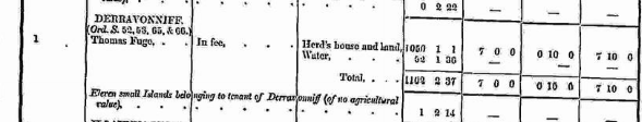
In Griffith’s Valuation the area was 1050 acres, 1 rood & 1 perch of land & buildings with a rateable value of £7-10s-0d. There was 52 acres 1 rood & 30 perch of Water in the townland.
Occupier: Thomas Fuge
Immediate Lessor: In fee.
“in fee”, meaning that the occupier is also the legal owner of the property.
View the heads of households in the townland at this time.
Poor Law Union Ireland
In Ireland the Poor Relief Act of 1838 divided into districts or “unions” in which the local taxable inhabitants were to be financially responsible for all paupers in the area. In 1898 the Poor Law Union was adopted as the basic administrative division in place of the civil parish and barony. Further subdivision into 828 registration districts and 3,751 district electoral divisions followed. Townlands were not arranged according to these divisions with parish and barony retained as a means to make comparisons with records gathered before 1898.
The 1838 Act
The main provisions of the 1838 Act were:
- The extension of the existing Poor Law Commissioners’ powers to Ireland, with the appointment of Assistant Commissioners who were to implement the Act in Ireland.
- The division of the country into Poor Law Unions based on Irish electoral divisions which were themselves made up from townlands.
- The creation of a Board of Guardians for each Union, two-thirds of whom were to be elected, the other third to be appointed ex officio.
- The setting up of a workhouse in each Union.
- The collection of a local poor-rate to finance the system.
- Assistance for emigration.
Initially, 130 Unions were created, based upon 2,049 electoral divisions. The divisions were composed of townlands, a peculiarly Irish unit, traditionally of 120 Irish acres in area. (Between 1848 and 1850, an additional 33 Unions were created by subdividing and reorganizing the boundaries of some existing Unions, particularly in the west of the country.
Boards of Guardians were elected annually on 25th March. Only rate-payers were eligible for election, which effectively disenfranchised most of the native Irish who were usually tenants at this time. Rate-payers were allowed between one and six votes depending on the size of a valuation of their property.
What is a townland?
A townland is one of the smallest land divisions in Ireland. They range in size from a few acres to thousands of acres. Many are Gaelic in origin, but some came into existence after the Norman invasion of 1169. Derravonniff [changed from Derrauvonniff – u crossed out] is a townland.
Population & Census Information
People who lived here:
You can retrieve a list of people who lived in this townland from 1827 to 1911. This list is compiled from the following resources.
- The Tithe Applotment Books
- Griffith’s Valuation
- 1901 Census
- 1911 Census
List of nineteenth century and early twentieth century inhabitants of this townland.
1841-1891 Census
1841 – 3 houses with 18 people living in Derravonniff
1851 – 3 houses with 9 people,
1861 – 1 house with 10 people,
1871 – 3 house with 29 people,
1881- 3 houses (3 inhabited) with 28 people (17 males, 11 females). There were 21 outbuildings.
The valuation of Houses & Land in 1881 was £85 0s 0d.
1891 – 4 houses (4 inhabited) with 23 people (12 males, 11 females). There were 9 outbuildings.
The valuation of Houses & Land in 1891 was £60 15s 0d.
1901 Census
This is a return of the members of the family, visitors, boarders or servants who slept or abode in their house on the night of Sunday March 31st 1901 in Derravonniff.
There were 6 houses (2 uninhabited) listed in the Townland of Derravonniff. 26 people (13 males and 13 females) lived in Derravonniff in the townland. 19 were Roman Catholic and 7 were Irish Church (Protestant Episcopalian). The people living in Derravonniff were born in Co. Galway, Co. Kilkenny & Co. Wicklow. There was a lunch house. There were 16 farm buildings and out offices which included stable, coach houses, harness room, cow houses, fowl house, turf house, kennel, laundry & a boat house.
Enumerators Extract
http://www.census.nationalarchives.ie/reels/nai000838157/
House & Building Return
http://www.census.nationalarchives.ie/reels/nai000838158/
Out Office & Farm Steadings
http://www.census.nationalarchives.ie/reels/nai000838159/
House 1
Martin Griffin aged 20 was head of the family; single. He lived his sister Bridget aged 25, also single.
Martin was a farmer and Bridget was a housekeeper. They could not read; both spoke Irish & English. They were Roman Catholic.
They lived in a 3rd class house with 2 rooms and 1 front window. They had a cow house & a piggery. This was a private dwelling.
http://www.census.nationalarchives.ie/pages/1901/Galway/Camus/Derravonniff/1393022/
House 2
Matthias Geoghegan aged 60 was head of the family; married to Kate aged 42. They lived with their children Bridget aged 14, Mary aged 12, Pat aged 10, Matthias aged 8, Peter aged 6, his widowed mother Bridget Geoghegan aged 99 and nephew John Walsh aged 35, single.
Matthias was a farmer; Kate was a farmer’s wife; the children were scholars; Bridget was a retired farmer & John was a farm servant. Matthias, Kate, Bridget & John could not read. The children could read & write. The entire household spoke Irish & English. They were Roman Catholic.
They lived in a 3rd class house with 2 rooms and 1 front window. They had a cow house & a piggery. This was a private dwelling.
http://www.census.nationalarchives.ie/pages/1901/Galway/Camus/Derravonniff/1393023/
House 3
John Geoghegan aged 70 was head of the family; married to Mary aged 45. They lived with their children Michael aged 20, John aged 18, Thomas aged 16, Kate aged 12, Julia aged 10, all single and daughter Bridget Naughton aged 25, married.
John was a farmer; Michael, John & Thomas were farmer’s sons; Kate & Julia were scholars and Bridget was a housekeeper. John, Mary & Bridget could not read. Michael, son John, Thomas, Kate & Julia could read & write. The entire family spoke Irish & English. They were Roman Catholic.
They lived in a 3rd class house with 2 rooms and 1 front window. They had a cow house & a piggery. This was a private dwelling.
http://www.census.nationalarchives.ie/pages/1901/Galway/Camus/Derravonniff/1393024/
House 4
James James aged 44 was head of the family; married to Maria aged 40. They lived with their children William aged 10, Adam aged 8, Laura aged 6, Sarah aged 4 & Maria aged 2.
James was a gamekeeper. Maria was a housekeeper. William, Adam, Laura & Sarah were scholars. James, Maria, William, Adam & Laura could read and write. Sarah & daughter Maria could not read. The family were members of the Irish Church. James, Maria & Adam were born in Co. Kilkenny. William, Laura, Sarah & Maria were born in Co. Wicklow.
They lived in a 3rd class house with 2 rooms and 1 front window. They had a kennel. This was a private dwelling.
http://www.census.nationalarchives.ie/pages/1901/Galway/Camus/Derravonniff/1393025/
1911 Census
This is a return of the member of the family, their Visitors, Boarders, and Servants who slept or abode in their house on the night of 31st of March 1901 in Derravonniff. There were 7 houses listed in the townland of Derravonniff. 27 (14 males/ 13 females), 22 Roman Catholics & 5 Presbyterians. The people that lived in Derravonniff were born in Co. Galway, Scotland & Co. Donegal.
There were a total of 21 farm buildings and out offices which included stable, coach houses, cow houses, dairy, fowl house, turf house, boiling house, stores, piggeries & sheds.
Enumerator’s Extract
http://www.census.nationalarchives.ie/reels/nai002430777/
House & Building Return
http://www.census.nationalarchives.ie/reels/nai002430779/
Out Office & Farm Steadings
http://www.census.nationalarchives.ie/reels/nai002430781/
House 1 (uninhabited)
It was a 1st class house with 6 rooms and 8 front windows. It was a private dwelling. It had a stable, coach house, cow house, dairy, fowl house, boiling house, turf house, 4 sheds, 2 stores & a laundry.
House 2
Angus Fraser aged 43 was head of the family; married to Jessie aged 44. They lived with their children Janet aged 12, Catherine aged 8 & Malcolm aged 3.
Angus was a gamekeeper. Janet & Catherine were scholars. Angus & Jessie spoke Irish & English; Janet, Catherine & Malcolm spoke only English. Angus, Jessie, Janet & Catherine could read & write. Malcolm could not read. The family were members of the Church of Scotland.
Angus & Jessie were married for 13 years; they had 5 children with 3 living at the time of the census. Angus, Jessie & Catherine were born in Scotland’ Janet was born in Co. Donegal & Malcolm was born in Co. Galway.
They lived in a 3rd class house with 2 rooms and 1 front window. This was a private dwelling.
http://www.census.nationalarchives.ie/pages/1911/Galway/Camus/Derravonniff/469825/
House 3
Martin Griffin aged 30 was head of the family; married to Mary aged 28. They lived with their children Mary aged 7, Bridget aged 5, Anne aged 4 & Colman aged 2.
Martin was a farmer. The family could not read; Martin & the children spoke only Irish. Mary (mother) spoke Irish & English. They were Roman Catholic.
Martin & Bridget were married for 8 years; they had 5 children with 4 living at the time of the census.
They lived in a 2nd class house with 2 rooms and 3 front windows. They had a cow house & a piggery. This was a private dwelling.
http://www.census.nationalarchives.ie/pages/1911/Galway/Camus/Derravonniff/469826/
House 4
John Geoghegan aged 75 was head of the family; married to Mary aged 68. They lived with their children Michael aged 31, Tom aged 25, Julia aged 20, all single and granddaughter Mary Naughton aged 8, & grandson Colman Naughton aged 6.
John & Michael were farmers. Tom was a gardener. John & Mary Naughton could not read. Michael could read & write. John, Michael, Tom, Julia, Mary Naughton & Colman spoke Irish & English. Mary Geoghegan spoke only Irish. They were Roman Catholic.
John & Mary had 12 children with 10 living at the time of the census.
They lived in a 3rd class house with 2 rooms and 2 front windows. They had a cow house & a piggery. This was a private dwelling.
http://www.census.nationalarchives.ie/pages/1911/Galway/Camus/Derravonniff/469827/
House 5
Matthias Geoghegan aged 68 was head of the family; married to Kate aged 67. They lived with their children Mary aged 23, Pat aged 22 & Peter aged 19.
Matthias was a farmer. Matthias & Kate could not read. Mary, Pat & Peter could read & write. The entire family spoke Irish & English. They were Roman Catholic.
Matthias & Kate were married for 28 years; they had 5 children with all 5 living at the time of the census.
They lived in a 3rd class house with 1 room and 2 front windows. They had a cow house & a piggery. This was a private dwelling.
http://www.census.nationalarchives.ie/pages/1911/Galway/Camus/Derravonniff/469828/
House 6
John Walsh aged 53 was head of the family; married to Bridget aged 47. They lived with their children Pater aged 7 & John aged 9 months.
John was a gardener & Peter was a scholar. The family could not read and spoke only Irish. They were Roman Catholic.
John & Bridget were married for 9 years; they had 3 children with 2 living at the time of the census.
They lived in a 3rd class house with 1 room and 2 front windows. They had a cow house & a piggery. This was a private dwelling.
http://www.census.nationalarchives.ie/pages/1911/Galway/Camus/Derravonniff/469829/
House 7 – Screebe Protestant Church.
Church records of births, deaths and marriages:
Church records of births, deaths and marriages are available online at http://www.rootsireland.ie To search these records, you will need to know the ‘church parish’ rather than the ‘civil parish’. (The civil parish is the pre-reformation parish and was frequently used as a unit of administration in the past.)
Derravonniff [changed from Derrauvonniff – u crossed out] is in the civil parish of Kilcummin.
Roman Catholic parishes:
This civil parish corresponds with the following Roman Catholic parish or parishes.
- Carraroe
- Kilannin
- Kilcummin/Oughterard
- Rosmuc
Church of Ireland parishes:
This civil parish corresponds with the following Church of Ireland parish.
- Kilcummin
In general, the civil parish and the Church of Ireland parish are the same, but, this is not always the case.
Maps
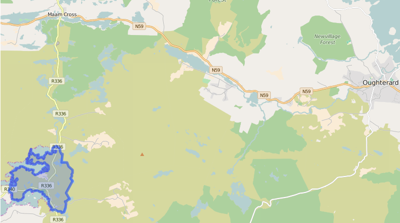
It is located at 53° 23′ 17″ N, 9° 33′ 9″ W.
Original OS map of this area. Ireland was first mapped in the 1840s. These original maps are available online.
Derravonniff [changed from Derrauvonniff – u crossed out]
Original OS maps at the Ordnance Survey of Ireland website.
Below is a link to the Ordnance Survey of Ireland website. It displays the original OS map that was created in the 1840s.
Derravonniff [changed from Derrauvonniff – u crossed out]
Information from Google Maps. You can use this link to find this townland on Google Maps.
Information from the National Monuments Service.
You can use this link to view a map of archaeological features. This link brings you to a website wherein you will have to search for your townland.
Archaeological map from the National Monuments Service
Galway Library Website
http://places.galwaylibrary.ie/place/52253
Townlands.ie Website
https://www.townlands.ie/galway/moycullen/kilcummin/camus/derravonniff/


No Comments
Add a comment about this page