Curraghduff West
Text - Mary Kyne, Hyperlinks - Antoinette Lydon


Curraghduff West is in the civil parish of Kilcummin. The civil Parish corresponds with the following Church of Ireland parish of Kilcummin, Galway West. In general the civil parish and the Church of Ireland parish are the same as is the case in the Kilcummin Oughterard area.
The Irish form of the name is Currach Dubh – black moor.
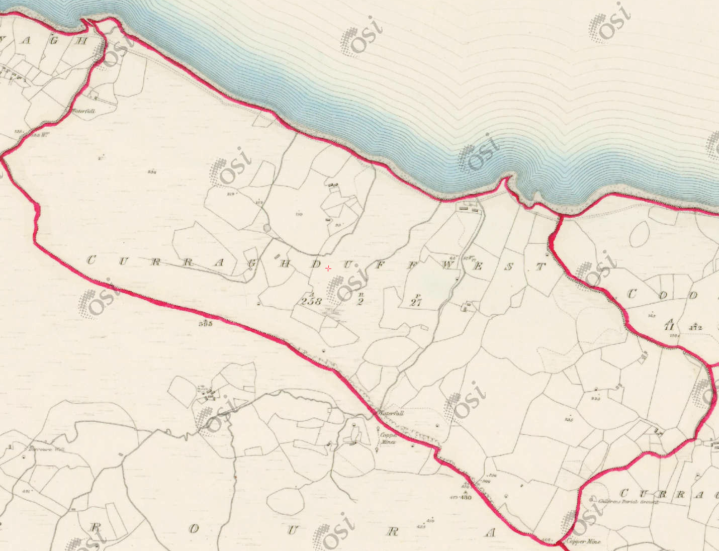
This large townland lies west of Curraghduff middle and Coosan and runs along the lake shore to Shannawagh. It is largely covered with native woodland and state forest.
Curraghduff West is in the Electoral Division of Letterfore, in Civil Parish of Kilcummin, in the Barony of Moycullen, in the County of Galway
1641 – The Earl of Clanrickard was the landlord.
1829 Tithe Applotment Books: The following names were listed; Patrick Gill, James Conner, Thos. Joyce, James Madden, William Right, Pall Staunton, Pall Sullivan, Mark Walsh and Patt Griffin – ( Pall could have been ‘Paul”)
Information From O’Donovan’s Field Name Books
Irish Form of Name: Currach Dubh
Translation: black moor
Parish: Kilcummin
Other Forms of the Name with the authority source (if provided) in italics.
Curraghduff
Currach Dubh
Curraghdhu West Boundary Surveyor
Currghduffe Barony Cess Book
Curraghduff West Local
Curraghduffe Inquis. Temp. Jac. I
Clynagh Island B. S. Sketch
Description:
Robert Martin, Esq., Ross, Proprietor. Land very bad stony and mountainous. Contains 258¾ acres about 150 acres under tillage and pasture, the remainder is boggy and mountain pasture, a precipice the top of which forms part of its southern boundary together with a water fall. Contains 102¾ acres of rough pasture situated S. of Innisheltia and N.W. of Drughillaunbeg.
Situation:
Situated in the Northern extremity of the parish. Bounded on the N. by Lough Corrib on the E. by Cossaun and Curraghdhu Middle, on the W. by Shannawagh and on the S. by Derroura townland. In the sea, it belongs to the townland of Russmuck.
Landlords
Martin (Ross) – The Martin family were established beside Ross Lake in the barony of Moycullen, county Galway, from the late 16th century, where they purchased land from the O’Flahertys. They were Royalist supporters and were dispossessed of their property in the city of Galway by the Cromwellians. Robert Martin received a grant of 2,909 acres in the barony of Moycullen, by patent dated 21 Aug 1677. Jasper Martin of Ross, who died in 1700, had two sons Jasper and Richard, from whom descend the two branches of the family settled at Ross and Ballynahinch. Nicholas Martin, who died in 1811, married Elizabeth O’Hara, daughter of Robert O’Hara of Lenaboy, and according to Burke’s ”Landed Gentry”, a grandniece of James O’Hara, 2nd Baron Tyrawley. Their grandson, James Martin of Ross, had sixteen children from his two marriages. His daughter, Maud, married H. Callwell and they were the parents of the author, J. M. Callwell. The youngest daughter of James Martin was Violet Florence Martin of the well known literary team Somerville and Ross. The Martins of Ross owned 5,767 acres in county Galway in the 1870s. They advertised the sale of their estate in the Landed Estates’ Martin (Ballynahinch) – A branch of the Anglo Norman family of Martin, one of the Tribes of Galway, was granted the O’Flaherty lands in the Connemara region in the mid 17th century. This family were a junior branch of the Martins of Ross and under the Acts of Settlement were granted vast estates in counties Galway, Mayo, Roscommon, Clare and Sligo. By a patent dated 1698 they were confirmed in the possession of their Connemara estate known as the Manor of Claremount by King William. The Westport Estate Papers document the sale of over 27,000 acres in the baronies of Moycullen and Ballynahinch by the trustees for the sale of Colonel John Browne’s estate to John Edwards for Richard Martin in 1699. The early generations of Martins lived at Birch Hall and Dangan, in the townland of Oranhill, parish of Rahoon, near Galway city. Richard Martin, better known as ‘Humanity Dick’, was the first member of the family to be reared as a Protestant. He was a famous duellist and founded the Society for the Prevention of Cruelty to Animals. Ballynahinch Castle was built in the centre of his estate. His son Thomas Martin died in 1847 during the Famine and Thomas’s only daughter and heir, Mary Laetita, inherited a heavily encumbered estate. She married her cousin, Arthur Gonne Bell, and died in New York in 1850. The Martin estates were offered for sale in two sections in 1849. Their property close to Galway town included Dangan, Corcullen, Bushypark and Killeen. Their Connemara estate was acquired by the Law Life Assurance Society in 1852, to whom it was heavily mortgaged. In 1853 the estate of almost 200,000 acres was surveyed by Thomas Colville Scott for a prospective buyer. Richard Martin, second son of Richard ‘Humanity Dick’ Martin of Ballynahinch, is recorded as holding five townlands in the parish of Killannin, barony of Moycullen, county Galway, at the time of Griffith’s Valuation although he emigrated to Canada in 1833. He was also recorded as the occupier of Clareville, a Martin home in the village of Oughterard. Many of his descendants still reside in Canada.
Information from the Down Survey Website:
The Down Survey is a mapped survey. Using the Civil Survey as a guide, teams of surveyors, mainly former soldiers, were sent out under Petty’s direction to measure every townland to be forfeited to soldiers and adventurers. The resulting maps, made at a scale of 40 perches to one inch (the modern equivalent of 1:50,000), were the first systematic mapping of a large area on such a scale attempted anywhere. The primary purpose of these maps was to record the boundaries of each townland and to calculate their areas with great precision. The maps are also rich in other detail showing churches, roads, rivers, castles, houses and fortifications. Most towns are represented pictorially and the cartouches, the decorative titles, of each map in many cases reflect a specific characteristic of each barony. http://downsurvey.tcd.ie/
The Down Survey website will tell you who owned this townland in 1641 (pre Cromwell) and in 1671 (post Cromwell).
Townland of CURRAGHDUFF WEST
Down Survey Name: Curragduffe
1641 Owner(s): O’Flahartye, Bryan (Catholic)
1670 Owner(s): Blake, Andrew (Protestant)
County: Galway
Barony: Muckullin
Parish: Killcumyn
Unprofitable land: 22 plantation acres
Profitable land: 45 plantation acres
Forfeited: 45 plantation acres
Down Survey Website
The Tithe Applotment Books
About the Records
Tithes were a tax on agricultural produce which was payable by the occupiers of agricultural land. They were the main source of income for the parish clergy of the Church of Ireland (the largest Protestant church and the church established by law). However, in many parishes a large part of the tithes were ‘appropriate’, which meant that they were payable to a bishop, cathedral chapter or other ecclesiastical recipient, or were ‘impropriate’, which generally meant that they were payable to a local landowner. The parishes used in the Tithe Applotment Books are civil or Church of Ireland parishes, which often differ in name and territory from Catholic parishes,
Acts of Parliament of 1823 and 1832 provided for the conversion of tithes into a fixed charge on land, and specified the average price of wheat or oats in the parish in the seven years before 1821 as the basis on which the tithes would be calculated. They also extended the application of tithes to pasture, where previously they had been levied only on tillage.
This change in the law resulted in the valuation of individual holdings in almost all parishes containing agricultural land, in order to assess the portion of the tithes for which each occupier of land would be liable. The apportionment was recorded for each Church of Ireland parish in a Tithe Composition Applotment Book. The information was collected and the amounts were calculated by two Parochial Commissioners, one of whom was appointed by the cess-payers of the parish and the other by the relevant Diocese of the Church of Ireland. This procedure was carried out in over 2,500 parishes between the years 1823 and 1837.
The Tithe Applotment Books are in a variety of formats, from a few pages sewn together to elaborately bound volumes. In most cases they are written in manuscript throughout, although some consist of manuscript entries on printed questionnaires. The information in the books is broadly uniform and generally includes at least the name of occupier; the size of holding, the valuation and the tithe payable. In some cases more detailed information is provided. Some volumes have maps and most have certificates and correspondence attached.
The sub-divisions of the parish were recorded. Some of these subdivisions, such as ploughlands, ceased to be in official use after the six inch survey of the Ordnance Survey was completed in the 1840s. Only productive land was subject to tithe, and the books usually distinguish between this tithable land and untithable land such as roads or mountains. Tithable land was in some cases classified by quality, and a money value was given to each class. In some cases the proportion of tithe payable to the rector, vicar or lay proprietor of the tithes was set out. The column for observations was sometimes completed, with information about commonage, for example.
There are a number of other points that should be noted. The acreages given in the Tithe Applotment Books are in Irish or Plantation measure, which is 1.62 times larger than statute measure. Only occupiers of land at the time of the tithe composition are recorded, so not all heads of households living in a parish at the time are included. Only rural areas are systematically covered, although inhabitants of towns who held plots of cultivable land are included. The equivalent tax in urban areas, Minister’s Money, has left few records.
The Tithe Applotment Books are an important source of information for a wide variety of researchers of pre-Famine Ireland. They provide the first surviving national list of the occupiers of land, and are used by genealogists as a partial substitute for returns of the 1821 and 1831 censuses of population, which were destroyed in 1922. They also record information on the quality of land, and provide information on pre-Ordnance Survey territorial divisions, some of which were not recognized after the 1840s.
The National Archives hold the original Tithe Applotment Books only for the twenty-six counties of the Republic of Ireland. The books for the six counties of Northern Ireland are held in the Public Record Office of Northern Ireland in Belfast. (http://titheapplotmentbooks.nationalarchives.ie/search/tab/aboutmore.jsp)
John Conner, Patrick Gill, Thos Joyce, James Maddin, William Right, Pall Staunton, Pall Sullivan & Mark Walsh are listed as having 100 acres of land (20 acres 2nd Quality with a payment of 1s, 20 acres 3rd Quality with a payment of 3d, 20 acres 4th Quality with a payment of ½ d & 20 acres 5th Quality with a payment of ⅛d.)
Payment of Proportion of Tithes went to Richard Martin Esq, Rev. James Daly & Rev. John Wilson.
Griffiths Valuation 1850’s
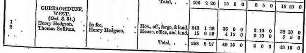
In Griffith’s Valuation the area is 258acres 2 roods 27 perches with a land value of £40 15s 0d and the value of buildings is £3, and the total value is £43 15s 0d.
Occupiers of the Land:
Henry Hodgson owned land, house, office and forge.
Thomas Sullivan owned a house, office and land
Landlord was Henry Hodgson
Annual Valuation
Henry Hodgson’s land 243acres 1rood 38 perches was rated £36 and buildings were rated £2 10s 0d.
Thomas Sullivan’s land 15acres 29 perches was rated £4 15s 0d and buildings were rated 10s.
http://www.askaboutireland.ie/griffith-valuation/index.xml?action=doNameSearch&PlaceID=558976
Out Offices and Land
The out office was a farm building, a cow house, piggery or barn. The land was very poor and sterile and people were always poverty-stricken. At this time most tenants were trying to eke out a living on 5acres or less and farmers needed at least 15.3 acres to survive.
Poor Law Union Ireland
In Ireland the Poor Relief Act of 1838 divided into districts or “unions” in which the local taxable inhabitants were to be financially responsible for all paupers in the area. In 1898 the Poor Law Union was adopted as the basic administrative division in place of the civil parish and barony. Further subdivision into 828 registration districts and 3,751 district electoral divisions followed. Townlands were not arranged according to these divisions with parish and barony retained as a means to make comparisons with records gathered before 1898.
The 1838 Act
The main provisions of the 1838 Act were:
- The extension of the existing Poor Law Commissioners’ powers to Ireland, with the appointment of Assistant Commissioners who were to implement the Act in Ireland.
- The division of the country into Poor Law Unions based on Irish electoral divisions which were themselves made up from townlands.
- The creation of a Board of Guardians for each Union, two-thirds of whom were to be elected, the other third to be appointed ex officio.
- The setting up of a workhouse in each Union.
- The collection of a local poor-rate to finance the system.
- Assistance for emigration.
Initially, 130 Unions were created, based upon 2,049 electoral divisions. The divisions were composed of townlands, a peculiarly Irish unit, traditionally of 120 Irish acres in area. (Between 1848 and 1850, an additional 33 Unions were created by subdividing and reorganizing the boundaries of some existing Unions, particularly in the west of the country.
Boards of Guardians were elected annually on 25th March. Only rate-payers were eligible for election, which effectively disenfranchised most of the native Irish who were usually tenants at this time. Rate-payers were allowed between one and six votes depending on the size of a valuation of their property.
Census 1881/ 1891
The Table shows that there were 4 Registrar’s Districts and Electorial Divisions in the Oughterard Poor Law Union. The total area of the whole Union was 172,289 acres. The table gives the number of houses and the population for each district from 1841, 1851, 1861, 1871, 1881, to 1891.The divisions of the Oughterard Union were Kilcummin, Letterfore, Oughterard and Wormhole. The total number of houses listed in 1841 were 4,465 and by 1881 there were 3,641 houses. The population in 1871 was 19,572 and by 1891 it was 18,975.
Townlands
A town land is one of the smallest land divisions in Ireland. They range in size from a few acres to thousands of acres. Many are Gaelic in origin, but some came into existence after the Norman invasion 1169. Curraghduff west is a townland and other place names in or near this townland are:
- Cappanamally (subdenomination)
- Killederdauowen (subdenomination)
Description: Killederdauowen
A subdenomination of West Curraghduff. Locally not known; was once a village.
Situation: In West Curraghduff townland.
Information From O’Donovan’s Field Name Books
Killederdauowen
Irish Form of Name: Coill Idir Dhá Abhainn
Translation: wood between two rivers
Other Forms of the Name with the authority source is in italics.
Killederdauowen
Coill Idir Dhá Abhainn
Coill Idir Dá Abhain
Killeragower Local
Kile-eidderauowen Local
Ancient name Killeragower T. H. O’Flaherty, Esq., Proprietor
Description:
A subdenomination thereof. Locality not known. Ancient name Kile edder an owen? or wood between two rivers, as there was actually a wood in it formerly.
Situation:
In Curraghduff townland.
Information From Joyce’s Place Names
Translation according to P. W. Joyce
Kill alone is the name of more than a score of places in various counties: in most cases it stands for cill, a church: but in some it is for coill, a wood.
Situated in what townland:
Killederdauowen is in the townland of Curraghduff West.
Population & Census Information
1841-1891 Census
1841: 5 houses with 28 people living in Curraghduff West.
1851: 3 houses with 15 people,
1861: 2 houses with 4 people,
1871: 2 houses with 16 person,
1881: 1 house with 6 people (1 male, 5 females). There was 1 out buildings. The valuation of Houses & Land in 1881 was £43 5s 0d.
1891: 2 house with 9 people (5 males, 4 females). There were 4 out buildings. The valuation of Houses & Land in 1891 was £42 5s 0d.
You can retrieve a list of people who lived in this townland from 1827 to 1911. This list is compiled from the following resources.
- The Tithe Applotment Books
- Griffith’s Valuation
- 1901 Census
- 1911 Census
List of nineteenth century and early twentieth century inhabitants of this townland.
1901 Census Curraghduff West
This is a return of the members of the family, visitors, boarders or servants who slept or abode in their house on the night of Sunday March 31st 1901 in Curraghduff West
There were 2 houses listed in the Townland of Curraghduff West. The people were all Roman Catholics and they were born in County Galway. There were 4 in total of farm buildings and out offices which 2 cow houses and 2 piggeries. There were 5 males and 6 females – a total of 11 persons living in the village at this time.
Class of House: The class of house depended on the materials used in the roof, walls, number of rooms and number of front windows. A 1st class house was considered the highest standard.
Walls of the houses: The walls were of stone, brick, and concrete or of mud, wood or other perishable material. The houses in Curraghduff were built of stone, brick or concrete. There were no mud cabins.
Landholder of the property unless otherwise stated was the lawful owner.
Roofs were of slate, iron, tiles, thatch, wood or other perishable material. The roofs of houses were of thatch, wood or perishable material. Most likely they were thatched as there were ample reeds for thatching in the lakes.
House Occupancy: Each of the 2 houses was occupied by one family.
The people listed as Head of the Family were also listed as the lawful Landholder of the property.
House 1: Barbara Sullivan a widow and farmer aged 60 was head of the family. Living with her was her son James a tailor aged 40 who was deaf and dumb and single, her son-in-law Martin Sullivan 39 married to her daughter Honor aged 29 and their children Mary 4, Bridget 3 and Barbara 1 also resided in the house. Martin Sullivan – Barbara’s husband was the lawful owner of the property. The family spoke Irish and English. Barbara, James and Martin didn’t read or write but Honor a housekeeper did read and write. 8 persons occupied 2 rooms. They lived in a Class 2 house with 3 front windows. They had a cowhouse and a piggery.
http://www.census.nationalarchives.ie/pages/1901/Galway/Letterfore/Curraghduff_West/1394460/
House 2: Patrick Sullivan A farmer aged 49 was head of the family. Living with him was his son Patrick 17 an agricultural farmhand and daughter Annie Mariah 16 a domestic worker. Patrick senior was born in Co. Galway but the children seem to have been born in Lankashire. They spoke Irish and English and they didn’t read or write. 3 persons occupied 2 rooms and they lived in a Class 2 house with 3 front windows. They had a cow house and a piggery.
http://www.census.nationalarchives.ie/pages/1901/Galway/Letterfore/Curraghduff_West/1394461/
Curraghduff West Census 1911
This is a return of the Members of families in Curraghduff West, their visitors, boarders and servants who slept or abode in the house on the night of Sunday the 2nd of April 1911.
Description of the Houses
All the houses in Curraghduff west were listed as private dwellings and were built of concrete or stone. The roofs of the houses were of wood, thatch or other perishable material. Most likely they were thatched. The head of the family were listed as the landholders. One family lived in each property. The Class of the house depended on the material used in the roof, walls, number of rooms and number of front windows. Most of the houses came under “2’ in the census form meaning that there could be 2, 3, or 4, rooms in the house.
17 persons lived in the townland – 12 males and 5 females.
House 1: Martin Sullivan a farmer aged 45 was head of the family. He lived with his wife Honor 38, Barbara 10, Patrick 9, Martin 7, Coleman 6, James 4, Sabiha 5 (could be Sabina), Bartley 3, Nora 2 and Joseph 1. They also had 2 other children Michael and Mary – (Glann Book). 11 persons occupied 2 rooms. The parents didn’t read or write but the older children did read and write. The family spoke Irish and English. They were married 14 years and 14 children were born alive and 12 children were still living. They lived in a class 2 house with 3 front windows. They didn’t seem to have any farm buildings.
Bartley took over the farm and lived there until 1976. Bartley was a great acordian player and singer. Bartley married Brigid Joyce from Glantrasna. They had 4 in family; Maureen, Bridie, Martin and Ann. His son Martin lives there now and has carried on the music tradition with some of his fine tinwhistle and flute playing on record. James Sullivan married Maria O ‘Brien from the neighbouring townland. Mary Rose Mons is their only daughter. Sabina married a man from Dublin named Mara. Their famous son P.J. was press secretary to the Taoiseach Charles J. Haughey.
http://www.census.nationalarchives.ie/pages/1911/Galway/Letterfore/Curraghduff__West/912157/
House 2; Barbara Sullivan a farmer and widow aged 76 was head of the family. Living with her was her son James aged 55 single and listed as a farmer’s son, John 89 her brother-in-law a widower and grandson Michael a scholar aged 7 also lived in the house. They lived in a class 2 house with 3 front windows. They spoke Irish and English but they didn’t read or write. 4 persons occupied 2 rooms. They had a cow-house.
http://www.census.nationalarchives.ie/pages/1911/Galway/Letterfore/Curraghduff__West/912156/
House 3: Patrick Sullivan a tenant farmer aged 59 was head of the family. He could read and write. Living with him was Anthony Mealie a servant aged 69 who didn’t read or write. Both men spoke Irish and English. Both were listed as being married. They lived in a class 2 house with 3 front windows. 2 people occupied 2 rooms. They had a cowhouse.
http://www.census.nationalarchives.ie/pages/1911/Galway/Letterfore/Curraghduff__West/912155/
There are three other houses which are holiday homes owned by John P. and Calire Alagheband, Michael and Barbara Bruglacher and Richard and Annie Arnold.
There was another Sullivan family in Curraghduff West living close to Curraghduff Middle. No record shows for them 1911 census. At that time John (Andre) Sullivan was at his uncle’s house in Farravaun. The family later moved to Loughgannon near Oughterard. John Andrew was a great athlete described as the best all-round athlete in the 3 parishes at running, jumping, cycling and football.
The local football pitch was at Faughnakill and also at Sratheeney in Currarevagh one of the biggest fields in Glann – 11acres.
Note: Script in italics is taken from ‘A Valley Remembers Glann’ 2013
Church records of births, deaths and marriages:
Church records of births, deaths and marriages are available online at http://www.rootsireland.ie. To search these records you will need to know the ‘church parish’ rather than the ‘civil parish’. (The civil parish is the pre-reformation parish and was frequently used as a unit of administration in the past.)
Curraghduff West is in the civil parish of Kilcummin.
Catholic parish:
This civil parish corresponds with the following Roman Catholic parish or parishes.
- Clonbern & Kilkerrin in Galway East.
- Carraroe in Galway West.
- Kilannin in Galway West.
- Kilcummin/Oughterard in Galway West.
- Rosmuc in Galway West.
Church of Ireland parish:
This civil parish corresponds with the following Church of Ireland parish.
- Kilcummin in Galway West.
In general, the civil parish and the Church of Ireland parish are the same, but, this is not always the case.
Maps
Original OS map of this area
Ireland was first mapped in the 1840s. These original maps are available online.
Original OS maps at the Ordnance Survey of Ireland website
Below is a link to the Ordnance Survey of Ireland website. It displays the original OS map that was created in the 1840s.
Information from Google Maps:
You can use this link to find this townland on Google Maps.
Information from the National Monuments Service:
You can use this link to view a map of archaelogical features. This link brings you to a website wherein you will have to search for your townland.
Archaeological map from the National Monuments Service
Galway Library Website
http://places.webworld.org/place/52184
Townlands.ie Website
https://www.townlands.ie/galway/moycullen/kilcummin/letterfore/curraghduff-west/


No Comments
Add a comment about this page