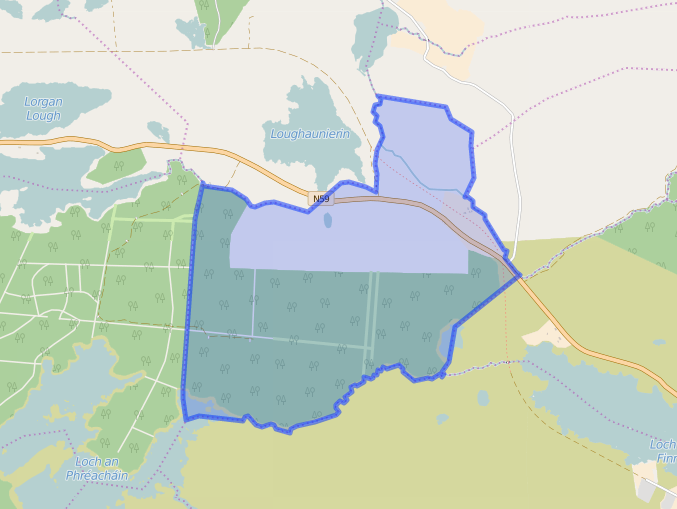
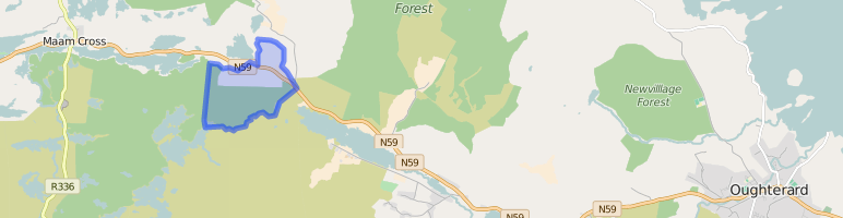
Bunnakill
Census Details
Mary Kyne & Antoinette Lydon


Bunnakill is in the civil parish of Kilcummin. The civil Parish corresponds with the following Church of Ireland parish of Kilcummin, Galway West. In general, the civil parish and the Church of Ireland parish are the same as is the case in the Kilcummin Oughterard area.
Bunnakill is in the Electoral Division of Letterfore, in Civil Parish of Kilcummin, in the Barony of Moycullen, in the County of Galway
Standard Name: Bunakyle
Irish Form of Name: Bun a Choill
Translation: bottom of the hazel
Parish: Kilcummin
View all place names in this civil parish.
Other Forms of the Name with the authority source (if provided) in italics.
Bunakyle
[Bunahyle changed to Bunnakill]
Bun a Choill
Bunnacul Boundary Surveyor
Bunnakell Barony Cess Book
Bunacile Local
Bunnkile Local
Comment: bass (base) of the wood
Area:
The land in Bunnakill is very bad, wet and mountainous. It contains about 15 acres of arable land; the remainder is mountain with the exception of eight acres of water – its total area is 544½ acres – was formerly a large wood.
Other placenames in this townland:
Some other placenames in or near this townland are …
- Loughanpreaghaun (lake)
- Loughaphreaghaun (lake)
- Thullantharawaun (hill)
- Tullantarvaun (rock)
A list of townlands that share a border with this townland:
This is a list of townlands that share a border with this townland.
Proprietor
Thomas B. Martin, Esq., Ballinahinch.
- Martin (Ballynahinch) – A branch of the Anglo Norman family of Martin, one of the Tribes of Galway, was granted the O’Flaherty lands in the Connemara region in the mid 17th century. This family were a junior branch of the Martins of Ross and under the Acts of Settlement were granted vast estates in counties Galway, Mayo, Roscommon, Clare and Sligo. By a patent dated 1698 they were confirmed in the possession of their Connemara estate known as the Manor of Claremount by King William. The Westport Estate Papers document the sale of over 27,000 acres in the baronies of Moycullen and Ballynahinch by the trustees for the sale of Colonel John Browne’s estate to John Edwards for Richard Martin in 1699. The early generations of Martins lived at Birch Hall and Dangan, in the townland of Oranhill, parish of Rahoon, near Galway city. Richard Martin, better known as ‘Humanity Dick’, was the first member of the family to be reared as a Protestant. He was a famous duellist and founded the Society for the Prevention of Cruelty to Animals. Ballynahinch Castle was built in the centre of his estate. His son Thomas Martin died in 1847 during the Famine and Thomas’s only daughter and heir, Mary Laetita, inherited a heavily encumbered estate. She married her cousin, Arthur Gonne Bell, and died in New York in 1850. The Martin estates were offered for sale in two sections in 1849. Their property close to Galway town included Dangan, Corcullen, Bushypark and Killeen. Their Connemara estate was acquired by the Law Life Assurance Society in 1852, to whom it was heavily mortgaged. In 1853 the estate of almost 200,000 acres was surveyed by Thomas Colville Scott for a prospective buyer. Richard Martin, second son of Richard ‘Humanity Dick’ Martin of Ballynahinch, is recorded as holding five townlands in the parish of Killannin, barony of Moycullen, county Galway, at the time of Griffith’s Valuation although he emigrated to Canada in 1833. He was also recorded as the occupier of Clareville, a Martin home in the village of Oughterard. Many of his descendants still reside in Canada. http://www.martinhistory.net/
Information from the Down Survey Website:
The Down Survey is a mapped survey. Using the Civil Survey as a guide, teams of surveyors, mainly former soldiers, were sent out under Petty’s direction to measure every townland to be forfeited to soldiers and adventurers. The resulting maps, made at a scale of 40 perches to one inch (the modern equivalent of 1:50,000), were the first systematic mapping of a large area on such a scale attempted anywhere. The primary purpose of these maps was to record the boundaries of each townland and to calculate their areas with great precision. The maps are also rich in other detail showing churches, roads, rivers, castles, houses and fortifications. Most towns are represented pictorially and the cartouches, the decorative titles, of each map in many cases reflect a specific characteristic of each barony. http://downsurvey.tcd.ie/
Townland of BUNNAKILL
Down Survey Name: Bunknocke
1641 Owner(s): Clanrickard, Earl of (Protestant)
1670 Owner(s): Clanrickard, Earl of (Protestant)
County: Galway
Barony: Muckullin
Parish: Killcumyn
Unprofitable land: 2608 plantation acres
Profitable land: 106 plantation acres
Forfeited: 106 plantation acres
The Down Survey website will tell you who owned this townland in 1641 (pre Cromwell) and in 1671 (post Cromwell).
Tithe Applotment Books:
About the Records
Tithes were a tax on agricultural produce which was payable by the occupiers of agricultural land. They were the main source of income for the parish clergy of the Church of Ireland (the largest Protestant church and the church established by law). However, in many parishes a large part of the tithes were ‘appropriate’, which meant that they were payable to a bishop, cathedral chapter or other ecclesiastical recipient, or were ‘impropriate’, which generally meant that they were payable to a local landowner. The parishes used in the Tithe Applotment Books are civil or Church of Ireland parishes, which often differ in name and territory from Catholic parishes, Acts of Parliament of 1823 and 1832 provided for the conversion of tithes into a fixed charge on land, and specified the average price of wheat or oats in the parish in the seven years before 1821 as the basis on which the tithes would be calculated. They also extended the application of tithes to pasture, where previously they had been levied only on tillage.
This change in the law resulted in the valuation of individual holdings in almost all parishes containing agricultural land, in order to assess the portion of the tithes for which each occupier of land would be liable. The apportionment was recorded for each Church of Ireland parish in a Tithe Composition Applotment Book. The information was collected and the amounts were calculated by two Parochial Commissioners, one of whom was appointed by the cess-payers of the parish and the other by the relevant Diocese of the Church of Ireland. This procedure was carried out in over 2,500 parishes between the years 1823 and 1837.
The Tithe Applotment Books are in a variety of formats, from a few pages sewn together to elaborately bound volumes. In most cases they are written in manuscript throughout, although some consist of manuscript entries on printed questionnaires. The information in the books is broadly uniform and generally includes at least the name of occupier; the size of holding, the valuation and the tithe payable. In some cases, more detailed information is provided. Some volumes have maps and most have certificates and correspondence attached.
The sub-divisions of the parish were recorded. Some of these subdivisions, such as ploughlands, ceased to be in official use after the six-inch survey of the Ordnance Survey was completed in the 1840s. Only productive land was subject to tithe, and the books usually distinguish between this tithable land and untithable land such as roads or mountains. Tithable land was in some cases classified by quality, and a money value was given to each class. In some cases, the proportion of tithe payable to the rector, vicar or lay proprietor of the tithes was set out. The column for observations was sometimes completed, with information about commonage, for example.
There are a number of other points that should be noted. The acreages given in the Tithe Applotment Books are in Irish or Plantation measure, which is 1.62 times larger than statute measure. Only occupiers of land at the time of the tithe composition are recorded, so not all heads of households living in a parish at the time are included. Only rural areas are systematically covered, although inhabitants of towns who held plots of cultivable land are included. The equivalent tax in urban areas, Minister’s Money, has left few records.
The Tithe Applotment Books are an important source of information for a wide variety of researchers of pre-Famine Ireland. They provide the first surviving national list of the occupiers of land, and are used by genealogists as a partial substitute for returns of the 1821 and 1831 censuses of population, which were destroyed in 1922. They also record information on the quality of land, and provide information on pre-Ordnance Survey territorial divisions, some of which were not recognised after the 1840s.
The National Archives hold the original Tithe Applotment Books only for the twenty-six counties of the Republic of Ireland. The books for the six counties of Northern Ireland are held in the Public Record Office of Northern Ireland in Belfast. (http://titheapplotmentbooks.nationalarchives.ie/search/tab/aboutmore.jsp)
Tithe Applotment Books – Bunnakill
Thos Lyons had 1 acre of 2nd quality land with a payment of 1s. The payment went to Richard Martin Esq. Rev. James Daly & Rev. John Wilson.
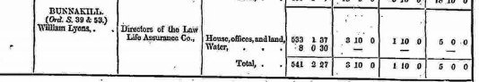
Griffiths Valuation 1850
In Griffith’s Valuation the area is 541 acres 2 rood 27 perches and area of Water: 8 acres 30 perches with a land value of £3 10s 0d. Value of Buildings is £1 10s 0d, and the total value is £5 0s 0d.
Occupiers of the Land: William Lyons
William occupied a house, out office and land.
Immediate Lessor: Directors of the Law Life Assurance Co.
http://www.askaboutireland.ie/griffith-valuation/index.xml?action=doNameSearch&PlaceID=558944
Out Offices and Land
The out office was a farm building, a cow house, piggery or barn. The land was very poor and sterile and people were always poverty-stricken. At this time most tenants were trying to eke out a living on 5acres or less and a farmers needed at least 15.3 acres to survive.
Poor Law Union Ireland
In Ireland the Poor Relief Act of 1838 divided into districts or “unions” in which the local taxable inhabitants were to be financially responsible for all paupers in the area. In 1898 the Poor Law Union was adopted as the basic administrative division in place of the civil parish and barony. Further subdivision into 828 registration districts and 3,751 district electoral divisions followed. Townlands were not arranged according to these divisions with parish and barony retained as a means to make comparisons with records gathered before 1898.
The 1838 Act
The main provisions of the 1838 Act were:
- The extension of the existing Poor Law Commissioners’ powers to Ireland, with the appointment of Assistant Commissioners who were to implement the Act in Ireland.
- The division of the country into Poor Law Unions based on Irish electoral divisions which were themselves made up from townlands.
- The creation of a Board of Guardians for each Union, two-thirds of whom were to be elected, the other third to be appointed ex officio.
- The setting up of a workhouse in each Union.
- The collection of a local poor-rate to finance the system.
- Assistance for emigration.
Initially, 130 Unions were created, based upon 2,049 electoral divisions. The divisions were composed of townlands, a peculiarly Irish unit, traditionally of 120 Irish acres in area. (Between 1848 and 1850, an additional 33 Unions were created by subdividing and reorganizing the boundaries of some existing Unions, particularly in the west of the country.
Boards of Guardians were elected annually on 25th March. Only rate-payers were eligible for election, which effectively disenfranchised most of the native Irish who were usually tenants at this time. Rate-payers were allowed between one and six votes depending on the size of a valuation of their property.
Townlands
A town land is one of the smallest land divisions in Ireland. They range in size from a few acres to thousands of acres. Many are Gaelic in origin, but some came into existence after the Norman invasion 1169. Bunnakill is a townland.
Population & Census Information
People who lived here:
You can retrieve a list of people who lived in this townland from 1827 to 1911. This list is compiled from the following resources.
- The Tithe Applotment Books
- Griffith’s Valuation
- 1901 Census
- 1911 Census
List of nineteenth century and early twentieth century inhabitants.
Census 1841-1891
1841 – 1 house with 6 people
1851 – 2 house with 10 people
1861 – 3 houses with 10 people
1871 – 1 houses with 5 people
1881 – 2 houses with 10 people (4 males & 6 females). There was 6 Out-buildings. Valuation of Houses & Lands £5 0s 0d.
1891 – 5 houses (4 occupied, 1 unoccupied) with 48 people (44 males & 4 females). There was 8 Out-buildings. Valuation of Houses & Lands £6 10s 0d.
1901 Census Bunnakill
This is a return of the members of the family, their Visitors, Boarders, Servants who slept or abode in their house on the night of Sunday March 31st 1901 in Bunnakill
There were 4 houses listed in the Townland of Bunnakill. The people were of mixed religions Roman Catholic Irish Church and English Church and they were born in County Galway, Mayo and Sligo. There were 8 in total of farm buildings and out offices which included, 3 stables, 3 cow houses, 1 piggery and a coach house. One house owned by William was vacant.
Class of House: The class of house depended on the materials used in the roof, walls, number of rooms and number of front windows. A 1st class house was considered the highest standard.
Walls of the houses: The walls were of stone, brick, concrete or of mud, wood or other perishable material. The houses in Bunnakill were built of stone, brick or concrete. There were no mud cabins.
Roofs Landholder of the property unless otherwise stated. Roofs were of slate, iron, tiles, thatch, wood or other perishable material. The roofs of 2 houses were of thatch, wood or perishable material. 2 houses were slated. Most likely they were thatched as there was ample reeds for thatching in the lakes.
House Occupancy: Each of the 3 houses was occupied by one family.
Enumerators Extract
http://www.census.nationalarchives.ie/reels/nai000840285/
House & Buildings Return
http://www.census.nationalarchives.ie/reels/nai000840286/
Out Offices & Farm Steadings
http://www.census.nationalarchives.ie/reels/nai000840287/
House 1: William Lyons aged 57 – a farmer was head of the family and the lawful landowner. His wife Annie 51 was born in Drumcliff, Co Sligo. She spoke English while William and his family spoke Irish and English. They belonged to the Irish Church and were born in Bunnakill. Living with William were Henry 24 and his sister Marion 22 – both single. The family could read and write. They lived in a private house Class 3 with 3 front windows. 4 persons occupied 2 available rooms.
http://www.census.nationalarchives.ie/pages/1901/Galway/Letterfore/Bunnakill/1394445/
House 2: Ralph Price aged 27 was listed as a boarder and a farm labourer. He could read and write and spoke English. He was single and was born in England. He belonged to the English Church. The landowner of the property was William Lyons.
http://www.census.nationalarchives.ie/pages/1901/Galway/Letterfore/Bunnakill/1394446/
House 3: It was vacant. It was a Class 3 house with 2 front windows. The property was owned by William Lyons. It was thatched.
House 4: John Hussey born in Co, Galway was head of the family aged 35. He lived with his wife Catherine 27 born in Co. Mayo. John was a Miles Man on the Railway and the property was owned by the Great Western Railway Company. Living with him were his children – Bridget 4, Margaret 3, Rose 2 and baby Ellen 6 months old. They could not read or write but they spoke Irish and English. It was a private dwelling, a Class 2 house with 2 front windows. The roof was slated. 6 persons occupied 3 available rooms.
http://www.census.nationalarchives.ie/pages/1901/Galway/Letterfore/Bunnakill/1394447/
Bunnakill Census 1911
This is a return of the Members of families in Bunnakill, their visitors, boarders and servants who slept or abode in the house on the night of Sunday the 2nd of April 1911.
Description of the Houses
All the houses in Bunnakill were listed as private dwellings and were built of concrete or stone. The roofs of the houses were of wood, thatch or other perishable material. Most likely they were thatched. The head of the family were listed as the landholders. One family lived in each property. The Class of the house depended on the material used in the roof, walls, number of rooms and number of front windows. Most of the houses came under “2’ in the census form meaning that there could be 2, 3, or 4, rooms in the house.
Enumerators Extract
http://www.census.nationalarchives.ie/reels/nai002434738/
House & Buildings Return
http://www.census.nationalarchives.ie/reels/nai002434740/
Out Offices & Farm Steadings
http://www.census.nationalarchives.ie/reels/nai002434742/
House 1: William Lyons aged 68 and head of the family was a farmer. He was married 5 years to Matilda 43 and they had no children. They belonged to the Irish Church. Living with them were Henry Lyons 27 William’s son, Ralph Price 32 a servant, Nancy Turner 13 a servant and Michael Connelly a servant who belonged to the Catholic Church. They were all single. They could read and write and they all spoke Irish and English. They lived in a private house the owner being William Lyons. It was a Class 2 house with 4 front windows. William had 3 stables, a horse house, cow house, calf house, potato house, fowl house, piggery and store. 6 persons occupied 4 available rooms.
http://www.census.nationalarchives.ie/pages/1911/Galway/Letterfore/Bunnakill/912141
House 2: John Toole aged 40 and head of the family lived with his sister May 36 and James 16 a scholar. They could read and write and they spoke Irish and English. They were Catholics. John and May were listed as Railway Miles Man. They lived in a Class 2 house with 2 front windows. They had a cow house and piggery. 3 persons occupied 2 available rooms.
http://www.census.nationalarchives.ie/pages/1911/Galway/Letterfore/Bunnakill/912142/
Church records of births, deaths and marriages:
Church records of births, deaths and marriages are available online at http://www.rootsireland.ie. To search these records, you will need to know the ‘church parish’ rather than the ‘civil parish’. (The civil parish is the pre-reformation parish and was frequently used as a unit of administration in the past.)
Bunakyle is in the civil parish of Kilcummin.
Catholic parish:
This civil parish corresponds with the following Roman Catholic parish or parishes.
- Clonbern & Kilkerrin in Galway East.
- Carraroe in Galway West.
- Kilannin in Galway West.
- Kilcummin/Oughterard in Galway West.
- Rosmuc in Galway West.
Church of Ireland parish:
This civil parish corresponds with the following Church of Ireland parish.
- Kilcummin in Galway West.
In general, the civil parish and the Church of Ireland parish are the same, but, this is not always the case.
Maps
Original OS map of this area
Ireland was first mapped in the 1840s. These original maps are available online.
Original OS maps at the Ordnance Survey of Ireland website
Below is a link to the Ordnance Survey of Ireland website. It displays the original OS map that was created in the 1840s.
Information from Google Maps:
You can use this link to find this townland on Google Maps.
Information from the National Monuments Service:
You can use this link to view a map of archaeological features. This link brings you to a website wherein you will have to search for your townland.
Archaeological map from the National Monuments Service
Townlands.ie Website
http://www.townlands.ie/galway/moycullen/kilcummin/letterfore/bunnakill/
Galway Library Website
http://places.galwaylibrary.ie/asp/fullresult.asp?id=51970


No Comments
Add a comment about this page