Birchall (Curraveha)
David Collins & Antoinette Lydon


Birchall or Curraveha is in the civil parish of Kilcummin. The civil Parish corresponds with the following Church of Ireland parish of Kilcummin, Galway West. In general, the civil parish and the Church of Ireland parish are the same as is the case in the Kilcummin Oughterard area.
Irish Form of Name: Corr a’ Bheithe
Translation: round hill of the birch
Civil Parish: Kilcummin View all place names in this civil parish.
Curraveha is in the Electoral Division of Oughterard, in Civil Parish of Kilcummin, in the Barony of Moycullen, in the County of Galway
The Irish name for Curraveha is Cora Bheithe
Curraveha is also known as Birchhall
Other Forms of the Name with authority source (if provided) in italics:
Birch Hall or Curraveha
Corr a’ Bheithe
Cor a’ beithe
Curravcha alias Birchall Barony Cess Book
Birch Hall Boundary Surveyor
Birch Hall County Map
Birch Hall or Curra Bhetha Local
Curraveha or Birch Hall R. Martin, Esq., Proprietor
West Birch Hall Rector of Killanni
Description:
Birchall or Curraveha contains 116½ acres, about 80 acres are under tillage and pasture, the remainder is bog and an old road leading to a village situate partly on the northern boundary of this townland.
Situation:
Situate in the Northern extremity of the parish. Bounded on the N. and W. by Ardnasillagh, on the E. by Lough Corrib and Knockbaan and on the S. by the parish of Killannin.
This is a list of townlands that share a border with this townland.
Some other placenames in or near this townland are…
- Inishflynn (island)
Landlord
Thomas B. Martin was a member of the Martin of Ross Family as stated in the Landed Estates Database.
- Martin (Ross) – The Martin family were established beside Ross Lake in the barony of Moycullen, county Galway, from the late 16th century, where they purchased land from the O’Flaherty’s. They were Royalist supporters and were dispossessed of their property in the city of Galway by the Cromwellians. Robert Martin received a grant of 2,909 acres in the barony of Moycullen, by patent dated 21 Aug 1677. Jasper Martin of Ross, who died in 1700, had two sons Jasper and Richard, from whom descend the two branches of the family settled at Ross and Ballynahinch. Nicholas Martin, who died in 1811, married Elizabeth O’Hara, daughter of Robert O’Hara of Lenaboy, and according to Burke’s” Landed Gentry”, a grandniece of James O’Hara, 2nd Baron Tyrawley. Their grandson, James Martin of Ross, had sixteen children from his two marriages. His daughter, Maud, married H. Callwell and they were the parents of the author, J. M. Callwell. The youngest daughter of James Martin was Violet Florence Martin of the well-known literary team Somerville and Ross. The Martins of Ross owned 5,767 acres in county Galway in the 1870s. They advertised the sale of their estate in the Landed Estates’ Court in May 1885.
- Martin (Ballynahinch) – A branch of the Anglo Norman family of Martin, one of the Tribes of Galway, was granted the O’Flaherty lands in the Connemara region in the mid-17th century. This family were a junior branch of the Martins of Ross and under the Acts of Settlement were granted vast estates in counties Galway, Mayo, Roscommon, Clare and Sligo. By a patent dated 1698 they were confirmed in the possession of their Connemara estate known as the Manor of Claremount by King William. The Westport Estate Papers document the sale of over 27,000 acres in the baronies of Moycullen and Ballynahinch by the trustees for the sale of Colonel John Browne’s estate to John Edwards for Richard Martin in 1699. The early generations of Martins lived at Birch Hall and Dangan, in the townland of Oranhill, parish of Rahoon, near Galway city. Richard Martin, better known as ‘Humanity Dick’, was the first member of the family to be reared as a Protestant. He was a famous duelist and founded the Society for the Prevention of Cruelty to Animals. Ballynahinch Castle was built in the center of his estate. His son Thomas Martin died in 1847 during the Famine and Thomas’s only daughter and heir, Mary Laetitia, inherited a heavily encumbered estate. She married her cousin, Arthur Gonne Bell, and died in New York in 1850. The Martin estates were offered for sale in two sections in 1849. Their property close to Galway town included Dangan, Corcullen, Bushypark and Killeen. Their Connemara estate was acquired by the Law Life Assurance Society in 1852, to whom it was heavily mortgaged. In 1853 the estate of almost 200,000 acres was surveyed by Thomas Colville Scott for a prospective buyer. Richard Martin, second son of Richard ‘Humanity Dick’ Martin of Ballynahinch, is recorded as holding five townlands in the parish of Killannin, barony of Moycullen, county Galway, at the time of Griffith’s Valuation although he emigrated to Canada in 1833. He was also recorded as the occupier of Clareville, a Martin home in the village of Oughterard. Many of his descendants still reside in Canada. http://www.martinhistory.net/
Down’s Survey
The Down Survey is a mapped survey. Using the Civil Survey as a guide, teams of surveyors, mainly former soldiers, were sent out under Petty’s direction to measure every townland to be forfeited to soldiers and adventurers. The resulting maps, made at a scale of 40 perches to one inch (the modern equivalent of 1: 50,000), were the first systematic mapping of a large area on such a scale attempted anywhere. The primary purpose of these maps was to record the boundaries of each townland and to calculate their areas with great precision. The maps are also rich in other detail showing churches, roads, rivers, castles, houses and fortifications. Most towns are represented pictorially and the cartouches, the decorative titles, of each map in many cases reflect a specific characteristic of each barony. (http://downsurvey.tcd.ie)
Townland of CURRAVEHA or BIRCHHALL
No townland information available
The down survey website will tell you who owned this townland in 1641 (pre Cromwell) and in 1671 (post Cromwell).
The Tithe Applotment Books
About the Records
Tithes were a tax on agricultural produce which was payable by the occupiers of agricultural land. They were the main source of income for the parish clergy of the Church of Ireland (the largest Protestant church and the church established by law). However, in many parishes a large part of the tithes was ‘appropriate’, which meant that they were payable to a bishop, cathedral chapter or another ecclesiastical recipient, or were ‘impropriate’, which generally meant that they were payable to a local landowner. The parishes used in the Tithe Applotment Books are civil or Church of Ireland parishes, which often differ in name and territory from Catholic parishes, Acts of Parliament of 1823 and 1832 provided for the conversion of tithes into a fixed charge on land, and specified the average price of wheat or oats in the parish in the seven years before 1821 as the basis on which the tithes would be calculated. They also extended the application of tithes to pasture, where previously they had been levied only on tillage.
This change in the law resulted in the valuation of individual holdings in almost all parishes containing agricultural land, in order to assess the portion of the tithes for which each occupier of land would be liable. The apportionment was recorded for each Church of Ireland parish in a Tithe Composition Applotment Book. The information was collected and the amounts were calculated by two Parochial Commissioners, one of whom was appointed by the cess-payers of the parish and the other by the relevant Diocese of the Church of Ireland. This procedure was carried out in over 2,500 parishes between the years 1823 and 1837.
The Tithe Applotment Books are in a variety of formats, from a few pages sewn together to elaborately bound volumes. In most cases they are written in manuscript throughout, although some consist of manuscript entries on printed questionnaires. The information in the books is broadly uniform and generally includes at least the name of occupier; the size of holding, the valuation and the tithe payable. In some cases, more detailed information is provided. Some volumes have maps and most have certificates and correspondence attached.
The sub-divisions of the parish were recorded. Some of these subdivisions, such as plough lands, ceased to be in official use after the six-inch survey of the Ordnance Survey was completed in the 1840s. Only productive land was subject to tithe, and the books usually distinguish between this tithable land and untithable land such as roads or mountains. Tithable land was in some cases classified by quality, and a money value was given to each class. In some cases, the proportion of tithe payable to the rector, vicar or lay proprietor of the tithes was set out. The column for observations was sometimes completed, with information about commonage, for example.
There are a number of other points that should be noted. The acreages given in the Tithe Applotment Books are in Irish or Plantation measure, which is 1.62 times larger than statute measure. Only occupiers of land at the time of the tithe composition are recorded, so not all heads of households living in a parish at the time are included. Only rural areas are systematically covered, although inhabitants of towns who held plots of cultivable land are included. The equivalent tax in urban areas, Minister’s Money, has left few records.
The Tithe Applotment Books are an important source of information for a wide variety of researchers of pre-Famine Ireland. They provide the first surviving national list of the occupiers of land, and are used by genealogists as a partial substitute for returns of the 1821 and 1831 censuses of population, which were destroyed in 1922. They also record information on the quality of land, and provide information on pre-Ordnance Survey territorial divisions, some of which were not recognized after the 1840s.
The National Archives hold the original Tithe Applotment Books only for the twenty-six counties of the Republic of Ireland. The books for the six counties of Northern Ireland are held in the Public Record Office of Northern Ireland in Belfast. (http://titheapplotmentbooks.nationalarchives.ie/search/tab/aboutmore.jsp)
James Clancy, Denis Hallaran, Matt Hallaran, Patt Halleran, Peter Halleran, Edmd Murry Peter Murry, Michl Walsh & Patt Walsh had a total of 63 acres; 24 acres of 1st class land with a payment of 1s 6d per acre. 12 acres 2nd quality with a payment of 1s per acre, 20 acres 3rd quality with a payment of 3d per acre & 7 acres of 4th quality land with a payment of ½d per acre. This land was listed as West Birchall.
The Tithes payments went to Richard Martin Esq. James Daly & John Wilson.
http://titheapplotmentbooks.nationalarchives.ie/reels/tab//004587459/004587459_00440.pdf
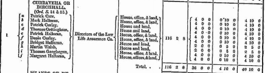
Griffiths Valuation – 1850’s
In Griffith’s valuation the total area was 116 acres, 2 rood & 8 perch of land with a total rateable value of £40 10s 0d for the Land & Buildings.
All the land is recorded as being owned by the Directors of the Law Life Assurance. Co. There are ten pockets of land recorded and ten tenants:
Patrick Carr House office and land £4.10s.
Mark Halloran House office and land £4.10s.
Patrick Curley House and land £4.10s.
Thomas Cottingham House and Land £4.10s.
Patrick Halloran House, office and Land £4.10s.
Dennis Curley House, office and land. £4.10s
Bridget Halloran House and land £2.10s
Martin Walsh House and land. £2.10s
Thomas Geoghegan House, office and land. £4.10s
Margaret Halloran House, office and land. £4.10s
View the heads of households in the townland at this time.
Poor Law Union Ireland
In Ireland the Poor Relief Act of 1838 divided into districts or “unions” in which the local taxable inhabitants were to be financially responsible for all paupers in the area. In 1898 the Poor Law Union was adopted as the basic administrative division in place of the civil parish and barony. Further subdivision into 828 registration districts and 3,751 district electoral divisions followed. Townlands were not arranged according to these divisions with parish and barony retained as a means to make comparisons with records gathered before 1898.
The 1838 Act
The main provisions of the 1838 Act were:
- The extension of the existing Poor Law Commissioners’ powers to Ireland, with the appointment of Assistant Commissioners who were to implement the Act in Ireland.
- The division of the country into Poor Law Unions based on Irish electoral divisions which where they made up from townlands.
- The creation of a Board of Guardians for each Union, two-thirds of whom were to be elected, the other third to be appointed ex officio.
- The setting up of a workhouse in each Union.
- The collection of a local poor-rate to finance the system.
- Assistance for emigration.
Initially, 130 Unions were created, based upon 2,049 electoral divisions. The divisions were composed of townlands, a peculiarly Irish unit, traditionally of 120 Irish acres in area. (Between 1848 and 1850, an additional 33 Unions were created by subdividing and reorganizing the boundaries of some existing Unions, particularly in the west of the country.
Boards of Guardians were elected annually on 25th March. Only rate-payers were eligible for election, which effectively disenfranchised most of the native Irish who were usually tenants at this time. Rate-payers were allowed between one and six votes depending on the size of a valuation of their property.
What is a townland?
A townland is one of the smallest land divisions in Ireland. They range in size from a few acres to thousands of acres. Many are Gaelic in origin, but some came into existence after the Norman invasion of 1169. Birch Hall or Curraveha is a townland
Population & Census Information
People who lived here:
You can retrieve a list of people who lived in this townland from 1827 to 1911. This list is compiled from the following resources.
- The Tithe Applotment Books
- Griffith’s Valuation
- 1901 Census
- 1911 Census
List of nineteenth century and early twentieth century inhabitants of this townland.
Census 1841-1891:
1841 – 16 houses with 107 people
1851 – 14 houses with 62 people
1861 – 15 houses with 72 people
1871 – 7 houses with 45 people
1881 – 7 houses with 42 people (20 males & 22 females). There were 13 outbuildings in the townland. Valuation of Houses & Lands £40 10s 0d.
1891 – 7 houses (6 inhabited) with 27 people (13 males & 14 females) There were 13 outbuildings in the townland. Valuation of Houses & Lands £40 10s 0d.
1841/1851 Old Age Pension Census Search Forms
An application was made by Flaherty from Curraveha in the Parish of Kilcummin in the Barony of Moycullen. Reference # Cen/S/1997. The surname McDonagh also appears on the application. Record was found for 1851.
An application was made by Lee from Curraveha in the Parish of Kilcummin in the Barony of Moycullen. Reference # Cen/S/1998. No Record for 1841was found.
An application was made by Lee from Curraveha in the Parish of Kilcummin in the Barony of Moycullen. Reference # Cen/S/1999. No Record for 1851was found.
An application was made by Julia Flaherty. Address: Mrs, Julia Beattie, Lettermullan, Co. Galway
Full Names of Father and Mother of the applicant: Michael & Margaret Flaherty ( née McDonagh)
Residence in 1851: Townland: Carraroe South, North, West, Curraveha (Birchall) Ard. Parish: Kilcummin, Barony: Moycullen, County: Galway
other names on the application Margaret, Bridget, Ellen
Notes written on application (see attached form)
Date of receipt: 2.10.16 Reference: CenS/11/1997 Application No. C/16 5733
Return searched by FW 19/10/16 see attached form FW 6/12/16 Not found. Ard
Copy despatched to Applicants address: 7.12.16.
2/- (3.11.16) 2/- written on top right corner of application
Additional form information
Michael (boatman) & Margaret Flaherty md – 1831 no return of Julia. Thos 16, John 14. Michael 20, Bridget 19 & Barbara 18 dead. Sheet 21 Carraroe North.
additional information on the family
An application was made by Thomas Lee. Address: No address entered
Full Names of Father and Mother of the applicant: Robert & Mary Lee
Residence in 1841: Townland: Curraveha or Birchall, Sure. Parish: Kilcummin, Barony: Moycullen, County: Galway
Date of receipt: 5 Sept 10 Reference: CenS/11/1998 Application No. D/10 18153
Return searched by JON 10/9/10 Particulars found: Family not found
An application was made by Thomas Lee. Address: No address entered
Full Names of Father and Mother of the applicant: Robert & Mary Lee
Residence in 1851: Townland: Curraveha or Birchall, Sure. Parish: Kilcummin, Barony: Moycullen, County: Galway
Date of receipt: 5 Sept 10 Reference: CenS/11/1999 Application No. D/10 18154
Return searched by JON 12.9.10 Particulars found: Family not found
1901 Census
This is a return of the members of the family, visitors, boarders or servants who slept or abode in their house on the night of Sunday March 31st 1901 in Birchall/Curraveha.
There were 5 family homes listed in the Townland of Birchall/Curraveha. The people were all Roman Catholics and they were born in Co. Galway. 20 people lived in Birchall/Curraveha (11 males and 9 females) in the townland. There were 12 farm buildings and out offices which included a stable, cow houses, a calf house, piggeries & a barn.
Enumerators Extract
http://www.census.nationalarchives.ie/reels/nai000840684/
House & Building Returns
http://www.census.nationalarchives.ie/reels/nai000840685/
Out Office & Farm Steading Return
http://www.census.nationalarchives.ie/reels/nai000840686/
House 1
Pat Carr aged 85 was head of the family; married to Sarah aged 60. They lived with their sons Pat aged 30 & Peter aged 25, both single.
Pat (father) was a farmer; Sarah was a housekeeper; Pat (son) & Peter were farmer’s sons. Pat (father), Sarah & Pat (son) could not read and spoke Irish & English. Peter could read and write and spoke Irish & English.
They lived in a 3rd class house with 2 rooms and 2 front windows. They had a stable, 2 cow houses, calf house, piggery & barn. This was a private dwelling.
http://www.census.nationalarchives.ie/pages/1901/Galway/Oughterard/Curraveha/1394626
House 2
Morgan Murry (Murray) aged 70 was head of the family, a widower. He lived with his children Peter aged 30, Edmund aged 25, Pat aged 23, Bridget aged 22 & Mary aged 20, all single.
Morgan was a farmer; Peter, Edmund & Pat were farmer’s sons; Bridget & Mary were farmer’s daughters. Morgan could not read and spoke only Irish. Peter, Edmund, Pat & Bridget could not read; they spoke Irish & English. Mary could read & write and spoke Irish & English.
They lived in a 3rd class house with 2 rooms and 1 front window. They had a cow house. This was a private dwelling.
http://www.census.nationalarchives.ie/pages/1901/Galway/Oughterard/Curraveha/1394627/ House 3
Bridget Walsh aged 28 was head of the family, a widow. She lived with her son Patrick aged 4 months.
Bridget was a farmer; she could not read and spoke Irish & English. Patrick could not read.
They lived in a 3rd class house with 2 rooms and 1 front window. They had a cow house & a piggery. This was a private dwelling.
http://www.census.nationalarchives.ie/pages/1901/Galway/Oughterard/Curraveha/1394628/
House 4
Denis Curley aged 60 was head of the family; married to Mary aged 50. They lived with their children Margaret aged 30, Michael aged 29 & Honor aged 28, all single.
Denis was a farmer; Mary was a housekeeper; Margaret & Honor were farmer’s daughter’s and Michael was a farmer’s son. Denis & Mary spoke only Irish. Margaret, Michael & Honor spoke Irish & English. The entire family could not read.
They lived in a 3rd class house with 2 rooms and 1 front window. They had a cow house & a piggery. This was a private dwelling.
http://www.census.nationalarchives.ie/pages/1901/Galway/Oughterard/Curraveha/1394629/ House 5
Michael O’Brien aged 80 was head of the family; married to Mary aged 60. They lived with their daughter Ellen aged 15.
Michael was a farmer; Mary was a housekeeper & Ellen was a farmer’s daughter.
Michael & Mary could not read; Ellen could read & write. The entire family spoke Irish & English.
They lived in a 3rd class house with 2 rooms and 1 front window. They had a piggery. This was a private dwelling. http://www.census.nationalarchives.ie/pages/1901/Galway/Oughterard/Curraveha/1394630/
Census 1911
This is a return of the Members of the families in Birchall/Curraveha, their visitors, boarders and servants who slept or abode in the house on the night of Sunday 2nd April 1911.
There were 5 houses listed in the Townland of Birchall/Curraveha. Of the people living in Birchall/Curraveha all 16 (9 males/7 females) were Roman Catholics & born in Co. Galway. There were a total of 15 farm buildings and out offices which included stable, cow houses, calf house, piggeries, fowl house, barns & a shed.
Enumerators Extract
http://www.census.nationalarchives.ie/reels/nai002435416/
House & Building Returns
http://www.census.nationalarchives.ie/reels/nai002435418/
Out Office & Farm Steading Return
http://www.census.nationalarchives.ie/reels/nai002435420/
House 1
Sarah Carr aged 80 was head of the family, a widow. She lived with her sons Peter aged 50 & Patrick aged 40, both single.
Sarah was a farmer; Patrick & Peter were farmer’s sons. Sarah could not read; Patrick & Peter could read and write; they spoke Irish & English.
They lived in a 3rd class house with 2 rooms and 2 front windows. They had a stable, cow house, calf house, piggery & barn. This was a private dwelling.
http://www.census.nationalarchives.ie/pages/1911/Galway/Oughterard/Curraveha_or_Birchhall/912301/
House 2
Peter Murray aged 48 was head of the family. He lived with his siblings Edward aged 46 & Bridget aged 38, all single.
Peter was a farmer; Edward was a farm labourer. Morgan could not read and spoke only Irish. Peter & Bridget could not read; Edward could read & write. All three spoke Irish & English.
They lived in a 3rd class house with 2 rooms and 2 front windows. They had a cow house & a piggery. This was a private dwelling.
http://www.census.nationalarchives.ie/pages/1911/Galway/Oughterard/Curraveha_or_Birchhall/912302/
House 3
Denis Curley aged 80 was head of the family, a widower. He lived with his children Maggie aged 40, Michael aged 36 & Honor aged 32, all single.
Denis was a farmer and Michael was a farmer’s son. Denis could not read and spoke only Irish. Maggie could not read; Michael & Honor could read & write; they spoke Irish & English.
They lived in a 3rd class house with 2 rooms and 1 front window. They had a cow house, piggery & a barn. This was a private dwelling.
http://www.census.nationalarchives.ie/pages/1911/Galway/Oughterard/Curraveha_or_Birchhall/912303/
House 4
James Barrett aged 46 was head of the family; married to Maggie aged 40. They lived with their children Mary aged 5, Patrick aged 3 & James aged 1.
James was a farmer. Parents James & Maggie could read & write and spoke Irish & English. They were married for 6 years; they had 3 children.
They lived in a 3rd class house with 2 rooms and 2 front windows. They had a cow house, piggery, barn & shed. This was a private dwelling.
http://www.census.nationalarchives.ie/pages/1911/Galway/Oughterard/Curraveha_or_Birchhall/912304/
House 5
Mary O’Brien aged 71 was head of the family, a widow. She lived alone.
Mary was a farmer; she could not read & spoke Irish & English.
She lived in a 3rd class house with 2 rooms & 1 front window. This was a private dwelling.
http://www.census.nationalarchives.ie/pages/1911/Galway/Oughterard/Curraveha_or_Birchhall/912305/
Church records of births, deaths and marriages:
Church records of births, deaths and marriages are available online at http://www.rootsireland.ie. search these records, you will need to know the ‘church parish’ rather than the ‘civil parish’. (The civil parish is the pre-reformation parish and was frequently used as a unit of administration in the past.)
Birch Hall or Curraveha is in the civil parish of Kilcummin.
Roman Catholic parishes:
This civil parish corresponds with the following Roman Catholic parish or parishes.
- Carraroe
- Kilannin
- Kilcummin/Oughterard
- Rosmuc
Church of Ireland parishes:
This civil parish corresponds with the following Church of Ireland parish.
- Kilcummin
In general, the civil parish and the Church of Ireland parish are the same, but, this is not always the case.
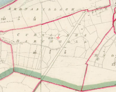
Maps
It is located at 53° 25′ 4″ N, 9° 14′ 59″ W.
Original OS map of this area.
Ireland was first mapped in the 1840s. These original maps are available online.
Original OS maps at the Ordnance Survey of Ireland website.
Below is a link to the Ordnance Survey of Ireland website. It displays the original OS map that was created in the 1840s.
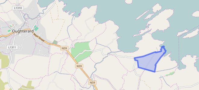
Information from Google Maps.
You can use this link to find this townland on Google Maps.
Information from the National Monuments Service.
You can use this link to view a map of archaeological features. This link brings you to a website wherein you will have to search for your townland.
Archaeological map from the National Monuments Service
Sources
Information from the Logainm database.
Townlands.ie Website
https://www.townlands.ie/galway/moycullen/kilcummin/oughterard/curraveha/
Galway Library Website
http://places.galwaylibrary.ie/place/51961


No Comments
Add a comment about this page