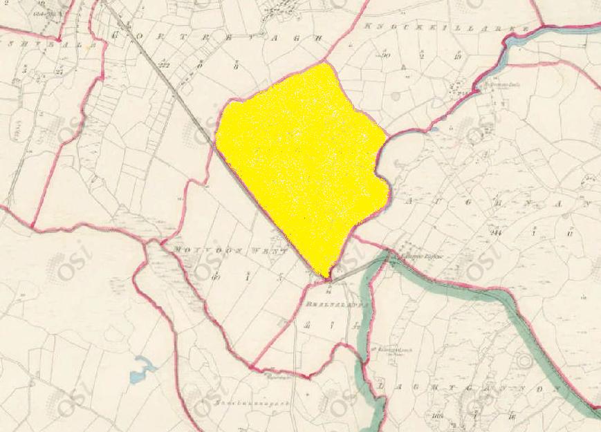
Moyvoon East
Townlands of Oughterard
By Paul Gibbons

Anglicized from Irish: Maigh Un/Mhuin Thoir
Translates to: “The plain of Un east” or “The plain of weeds east”
Etymology:
Moyvoon is another example of description versus story. The official translation is ‘the plain of Un’ which refers to a chieftain of the Fir Bolg. The Fir Bolg were a race of people who inhabited ancient Ireland and appear in the mythology of the country as the people who ruled the island before the coming of the Tuatha De Danann (effectively the ancient Irish gods). The Fir Bolg were the first to divide up the country into provinces and their names seem to be attached to numerous locations throughout Ireland. Local examples include the twelve bens named after Beola who was a member of the Fir Bolg and Galway which was named after Gaillimhe daughter of Breasail a local chieftain who supposedly drowned in the river beside the modern day city. Unfortunately, we do not have any surviving information or stories about how the townland was connected to Un or indeed about Un himself.
Another possible translation could be Maigh Mhuin which is pronounced similarly and means plain of the weeds. This is a much more logical explanation based on a topographical description. While the Un story is very possible as beliefs in gods and the ancestors was deeply rooted in ancient Irish society it could have also been a later adoption after the original description.
Size: 81 acres, 1 rods, 31 perchs
Siting:
In the northern extremity of Kilcummin parish. Bounded on the north by Gortrevagh and Knockkillaree, on the east by Aughnanure, and on the south by Moyvoon West and Bealnalappa.
Description:
Land very good, stony in parts, containing 81 and a half acres all under tillage and pasture except 16 acres of bog. There are two forts situated close to its southern boundary. The centre of the Galway and Oughterard road forms its south-west boundary.
Placenames within townland:
Ringfort 1 – In flat pasture-land. Marked on 1st edition of OSI 6-inch map as a circular enclosure (diameter c. 35m). No visible surface trace survives.
Ringfort 2 – In flat pasture-land c. 50 m north of Ringfort 1. Marked on 1st edition of OSI 6-inch map as a circular enclosure (diameter c. 15m). No visible surface trace survives.
Previous proprietor/landlord:
Earl of Clanrickard (1641)
Earl of Clanrickard (1670)
James O’Hara of Leanaboy House (c. 1850)
Land Value (1857): £ 20 s.15 d. 0
Buildings Value (1857): £ 3 s.0 d. 0
Surnames attached to the townland (1857-1911):
Fourisk, Furdon, Walsh, Welby, Faherty, Waters, Moloney


No Comments
Add a comment about this page