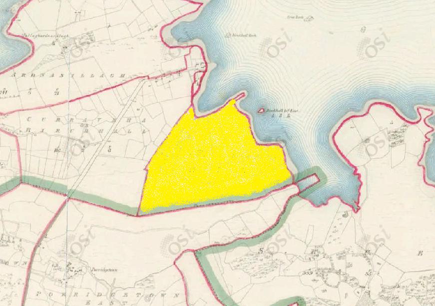
Knockbaun
Townlands of Oughterard
By Paul Gibbons

Anglicized from Irish: An Cnoc Bán / Cnoc an Badhún
Translates to: “The white hill” / “The hill of the bawn”
Etymology:
The official translation for this townland is “the white hill” coming from the Irish: An Cnoc Bán. While this name could arise to describe an area filled with whitethorn trees etc more often than not it doesn’t relate to the actual colour of the area. In many cases the term white can be used in relation to cow pastures. This could be a reference to milking etc or could be a corruption of the word bó (cow) or ba (cows) into bán (white). This said I believe that the proper translation for the placename would be “the hill of the bawn” from the Irish: Cnoc an Badhún. The townland is small and its main feature is a low rounded hillock in its centre. On the summit of this hill to this day is an enclosure which was present from at least the 1840s as it is included on the 1st edition OSI 6-inch map. This enclosure was most likely for keeping cattle hence why it would have probably been referred to as a bawn/badhún (from the Irish ba (cattle) and dhún (stronghold)). Given the structure’s location at the summit of the hill it would have acted as a defining focal point and hence could have sprouted the name.
Size: 77 acres, 1 rods, 38 perchs
Siting:
Situated in the northern extremity of Kilcummin parish. Bounded on the west by Curreveha/Birchall, on the north and east by Lough Corrib, and on the south by the parish of Killannin (Porridgetown East).
Description:
Contains 77 and a half acres about 70 acres of which are under tillage and pasture, the remainder is bog. There was a group of houses situated close to its northern boundary.
Placenames within townland:
Enclosure – On the summit of a low rounded hillock overlooking bogland to the south and Lough Corrib to the north east. It is a circular area (diameter c. 21m) enclosed by a very low, narrow bank (width c. 0.75m, height 0.5m ext.) which is much gapped and closely planted with whitethorn bushes. There are slight traces of an external fosse on the north-east side and a small irregular mound stands immediately to the east-north-east. Apart from its designation on the 1st edition OSI 6-inch map, and siting, the whole monument looks entirely modern.
Previous proprietor/landlord:
Daniell McMurragh O’Flahertye (1641)
Sir George Bingham (1670)
Robert Martin of Ross (c. 1850)
Land Value (1857): £ 25 s.0 d. 0
Buildings Value (1857): £ 0 s.10 d. 0
Surnames attached to the townland (1857-1911):
Kelly, Walsh, Molloy, Murray


No Comments
Add a comment about this page