Gortdrishagh
Townlands of Oughterard
By Paul Gibbons

Anglicized from Irish: An Gort Driseach
Translates to: “The briary field”
Etymology:
The name of this townland is fairly straighforward. It simply describes how the area once was before it became more extensively cultivated and was filled with various prickly scrambling shrubs such as blackberry bushes.
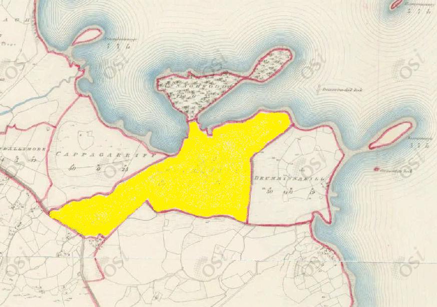
Size: 88 acres, 1 rods, 35 perchs
Siting:
In the northern extremity of Kilcummin parish. Bounded on the north by Annaghwood and Lough Corrib, on the west by Cappagarriff and Newvillage, on the east by Drumminnakill and on the south by Derreenmeel.
Description:
Land good, contains 88 and a half acres of land about 70 acres of which are under tillage and pasture, the remainder is bog and rough pasture. A neat house is situated in the northern extremity of this townland and there is also a gravel pit close to its southern boundary.
Placenames within townland:
Newvillage Bridge – Located at the south-eastern boundary of the townland linking the townlands of Gortdrishagh and Newvillage.
Gortdrisagh House - The National Inventory of Architectural Heritage indicates that this house was built in the latter part of the nineteenth century. At the time of Griffith’s Valuation, James O’Connor was leasing offices and land at Gortdrishagh from the Law Life Assurance Company.
Previous proprietor/landlord:
Murragh O’Brien O’Flahertye (1641)
Richard Martin (1670)
Thomas B Martin of Ballinahinch Castle (c. 1850)
Land Value (1857): £ 18 s.0 d. 0
Buildings Value (1857): £ 1 s.0 d. 0
Surnames attached to the townland (1857-1911):
Connor, Hegarty, Flaherty, Knox, McNamara, Noone


No Comments
Add a comment about this page