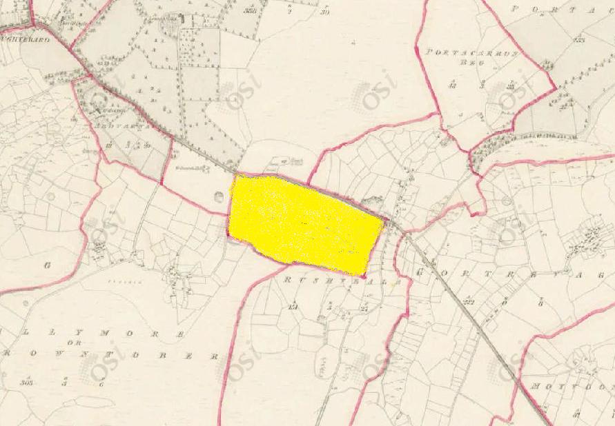
Glebe
Townlands of Oughterard
By Paul Gibbons

Anglicized from Irish: An Ghléib
Translates to: “The Glebe”
Etymology:
Before the construction of the Church of the Immaculate Conception in the town in 1837, Oughterard was described as “a neglected and mountainous district with a large scattered population of 10,000 souls and literally destitute of a house of worship”. This was due to the fact that the vast Oughterard area was serviced by a single small chapel located in Glebe at the turn from the main road into Rushveala/Magheramore. This chapel is no longer present however the junction is now referred to as Old Chapel. A Glebe is an area of land in addition to the parsonage house/rectory and grounds which was assigned to support the priest. Tithes were in early times the main means of support for the parish clergy but glebe land was either granted by any lord of the manor of the church’s parish, or accumulated from other donations of particular pieces of land. The amount of such land varied from parish to parish, it could entail complete farms, individual fields, houses, mills or works. The holder of the benefice (the priest) could retain the glebe for his own use, usually for agricultural exploitation, or he could lease it to others and retain a rent as income.
Size: 37 acres, 2 rods, 9 perchs
Siting:
In the eastern extremity of Kilcummin parish. Bounded on the north by Lemonfield and Rushveala, on the east by Rushveela, on the west by Lemonfield and Billymore/Carrowntober and on the south by Rushveala and Billymore/Carrowntober.
Description:
Contains 37 and a half acres all arable with the exception of about 14 acres of bog. Glebe House is situated in the eastern extremity of the townland. There is also an old fort and quarry situated close to its northern boundary.
Placenames within townland:
Ringfort – In poorly drained level pastureland. Marked on the 1st edition of OSI 6 inch map as a circular enclosure (diameter c. 35m). No visible surface trace survives.
Previous proprietor/landlord:
Richard Martin (1670)
Earl of Clanrickard (1670)
Rev. J. Wilson, Rector (c. 1850)
Land Value (1857): £ 18 s.10 d. 0
Buildings Value (1857): £ 7 s.0 d. 0
Surnames attached to the townland (1857-1911):
Lynn, O’Callaghan, Conneely, Gavin, White, Gallagher


No Comments
Add a comment about this page