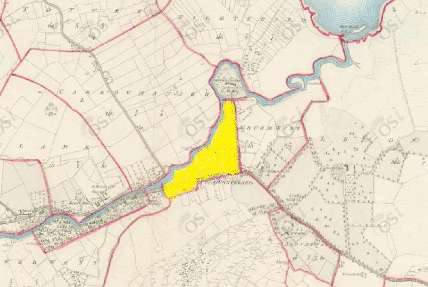
Fough West
Townlands of Oughterard
By Paul Gibbons

Anglicized from Irish: An Fhuathach Thiar
Translates to: “West Hate”
Etymology:
This townland gets its name from the river which forms its northern boundary. The River Fough is the main river which flows through Oughterard although it is rarely known by this name today. According to history, the river was renamed Abhainn na Ruibhe (translates to ‘the river of sulpher’ although now anglicized to Owenriff) when sulpher was found in the waters. Given its curative properties a well was established and Oughterard became a much frequented spa town. Although this is most likely all true the original name may not have been far from the more modern alternative. Fough is most likely an anglicized form of the word Fuath which means ‘hate/hatred’. This may be considered an odd name for a river but if you look at the link between hate and various other evil things and sulpher, also known as brimstone, you may be able to make sense of it. Sulpher is connected with the idea of Hell and evil things and hence when people became aware of the fact that sulpher was in the river they gave it a name which reflected the evil which they may have thought was connected to it. This is one theory as there may have possibly been a simple story/folktale which created the name and could explain its origins unfortunately it hasn’t survived to this day.
Size: 20 acres, 2 rods, 4 perchs
Siting:
In the northern extremity of Kilcummin parish. Bounded on the north by Carrowmanagh and Ordnance Ground, on the east by Fough East, on the west by Canrawer West and on the south by Cregg.
Description:
The centre of the Galway-Oughterard road forms the southern boundary and the road leading from Oughterard to Ordnance Ground (Camp Street) forms its eastern boundary.
Placenames within townland:
Tobernavaunia – Translates to ‘well of the warts’. A bullaun stone which has water in it all seasons, remarkable for curing warts.
Kilcummin Church – The church was built in 1810 on a one acre site of land. This original church consisted of the present nave and tower and was a small neat edifice that seated 70.
Previous proprietor/landlord:
Earl of Clanrickard (1641)
Earl of Clanrickard (1670)
Captain O’Flaherty of Lemonfield (c. 1850)
Land Value (1857): £ 22 s.11 d. 0
Buildings Value (1857): £ 142 s.5 d. 0
Surnames attached to the townland (1857-1911):
Murphy, Munster, Halloran, McDonagh, Stranger, Roche, Thorpe, Cashin, Geoghegan, Conneely, Clarke, O’Flaherty, St. Geroge, Sullivan, Kenny, Toohil, Griffin, Walsh, McNab, Loveday, Holden, McLeod, Evans, Donohoe, Joyce, Farrell, Dunlop, Flynn, Gill, Fitzpatrick, Welby, Higgins, Rutledge, Linsky, Heffernan, Madden, O’Flahertie, Cunningham, Darcy, Donnellan, Faherty, Conroy, Naughten, Carberry, Malloy, Lee, Malia, King, Barnacle, Keneavy, Tierney, Moloney, Lydon, Welsh, Curley, Davin, Derey, Mullen, Clegett, Mellet, Monaghan, Bird, Coyne, Hare, Mannion, Morris, Hogan, O’Meally, Thornton, Feeney, Gallaher, Roland, Callaghan, Craven, McGuinness, Geraghty, Mulkerrins, Mulvay, Roe, Toole, Waker, Finnerty, Clancy, O’Farrell, Davoren, McDonnell, Downey, Ross, McNable, Browne, Gibbons, Burke, Hogan, Canavan, Dixon, Jackson, Wally, Fegan, Reilly, Belton, Boulger, Quirk, Kelly


No Comments
Add a comment about this page