Eighterard
Townlands of Oughterard
By Paul Gibbons

Anglicized from Irish: Íochtar Árd
Translates to: “Lower Height”
Etymology:
The positioning of Oughterard village is interesting as although it is close to the shores of Lough Corrib it also has a commanding view over the lands further west (as one can see even from the vintage photos on this site). This obviously explains how the term Árd or ‘height’ became attached to the area and the names Oughterard and Eighterard arose from this description. The townland of Eighterard is found to the north of the village on the lower side of the river hence its name. Interestingly there is no official townland with the name Oughterard in existence today. However, the main part of the village lying to the south side of the river is the area most referred to as Oughterard (an anglicized form of Úachtar Árd meaning the ‘upper height’). Possibly the townland of Ordnance Ground, a later name coming with the military barracks in the mid 18th century, was once called Oughterard. It may also be possible that these two interconnected townlands were part of a very old settlement which pre-dates the modern village. This theory is strengthened given several facts: firstly, that the land in Eighterard is very fertile and perfect for farming. Secondly, it is close to the river and lake giving it a source of water, food and transportation. Thirdly, the townland of Ordnance Ground would have been easily defensible, given its height and the presence of water on three sides. And finally, that a castle did exist at that site in medieval times.
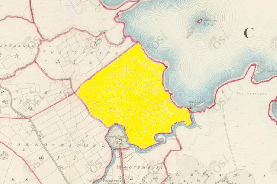
Size: 116 acres, 2 rods, 1 perchs
Siting:
In the northern extremity of Kilcummin parish. Bounded on the north-east by Lough Corrib, on the south-east by Lemonfield, on the north-west by Tullyvrick, on the south-west by Carrowmanagh and on the south by Ordnance Ground and Fough East.
Description:
Contains 116 acres all of which is under tillage except 2 acres of bog. There is a village situated in the northern part of the townland and an old fort in the centre of it. The centre of the Fough/Owenriff river forms part of the southern boundary of the townland.
Placenames within townland:
Enclosure (arch. remains) – In gently undulating grassland. Very poorly preserved subcircular area (diameter c. 39m) defined by a scarp from east through south to west. No surface traces survive elsewhere.
Previous proprietor/landlord:
Robert Martin (1641)
Donnogh Kelly (1670)
Arthur French St. George of Tyrone House (c. 1850)
Land Value (1857): £ 40 s.0 d. 0
Buildings Value (1857): £ 1 s.15 d. 0
Surnames attached to the townland (1857-1911):
Molloy, McCowan, Roche, Donnellan, McQuinn, McDonagh, Gill, Conneely, Faherty, Haughton


Comments about this page
thanks for this information
Add a comment about this page