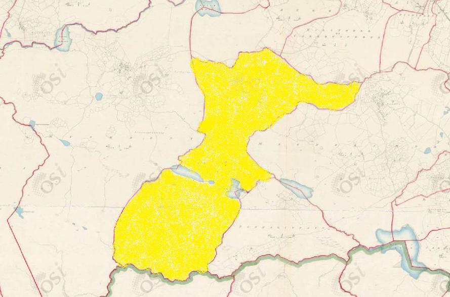
Clooshgereen
Townlands of Oughterard
By Paul Gibbons

Anglicized from Irish: Cluais Chéirín
Translate to: “Ear Wax”
Etymology:
This townland has one of the most interesting yet confusing names in the region. Body parts are a somewhat common occurrence in Irish placenames as they often are used to refer to the shape of an area of land. The term ‘cluas’ (ear) would most likely be applied to a piece of land which was large, possibly rounded (top part of ear) which then narrows down into a smaller area (ear lobe). This could be said to describe the townland quite accurately, it contains a large part of a mountain at one end then the area narrows around the borders of two lakes and finally expands slightly once again to encompass a hill. The term ‘chéirín’ is the more confusing element. It could be a diminutive version (addition of -ín meaning small) of the Irish word for wax: ‘céir’. There are several stories in Ireland of how local people gave wrong information to those recording placenames for numerous reasons one being their own enjoyment. Today the area is more often than not referred to simply as Cloosh which adds to the idea that ‘chéirín’ may have been added simply as a joke. It is also possible that the area was originally called Clooshgereen but they may have been given the wrong translation of ‘gereen’. Another possible translation may come from the Irish word ‘ghaoraidhín’ which means “little river valley”. As I have stated previously the townland contains a small area of land between a mountain and a hill which contains two lakes and various small streams which therefore may make this explanation possible.
Size: 913 acres, 0 rods, 11 perchs
Siting:
In the eastern extremity of Kilcummin parish. Bounded on the west by Rusheeny, on the south by Killannin parish (Luggakeeraun), on the north by Cregg and Billymore/Carrowntober, and on the east by Maghermore and Bunnagippaun.
Description:
It hasa triangulation point. Land very bad. Contains 895 and three quarter acres of land, about 60 of which are under tillage with an additional 17 and three quarters of water. The remainder is mountain pasture and bog. There is nothing remarkable in this townland.
Placenames within townland:
Béalagrooaun Bridge – An old bridge now nearly destroyed on the old road from Oughterard to Derenia (?)
Corkernarusheeny (hill) – Translates to ‘narrow pass of the little points’. A high hill in both Rusheeny and Clooshgereen (a boundary wall divides the hill) which has two peaks, each with a monument atop (cairn and ritual site/holy stone).
Mine (lead) – On northern boundary of townland at the base of Corkernarusheeny hill. Judging from the limited material available it is a continuation of the Glengowla mineralization. The site has been bulldozed several decades ago leaving no visible trace.
Holy Stone (arch. remains) – A stone that may be considered to have certain miraculous properties. These may have their origins in prehistory but are associated with devotions from the medieval period onwards.
Cairn (arch. remains) – A mound constructed primarily of stone which cannot be classified as a specific cairn type. These can date to any period from prehistory onwards.
Scalpcallyagayne (site) – Translates to ‘cleft of the foreign hag’ also known locally as ‘the strange nomad’s cliff’. Said to have been the residence of a woman who was a stranger in this country, one who lost her friends and left her home to perish on this cliff.
Previous proprietor/landlord:
Richard Martin (1670)
Earl of Clanrickard (1670)
Arthur French St. George of Tyrone House (c. 1850)
Land Value (1857): £26 s.19 d.0
Building Value (1857): £1 s.10 d.0
Surnames attached to the townland (1857-1911):
Kelly, Walsh, Connor, Burke


No Comments
Add a comment about this page