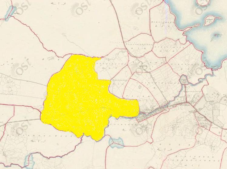
Claremount
Townlands of Oughterard
By Paul Gibbons

Anglicized from Irish: An Clár Mór
Translates to: “The Great Level Place”
Etymology:
Claremount doesn’t seem to be named for its topography as the area, although far from mountainous, does contain a number of hills. Therefore I think it should be seen as as an extension of Clare and indeed the Manor of Clare possibly suggesting that the name is of English rather than Irish origin. The Martins built Clareville House in this townland and intended to develop a town around the site therefore it can be seen as their early seat of power. Most likely they adopted the somewhat regal name of Claremount to signify that this was the centre of their estate and where they were going to build it to great heights.
Size: 569 acres, 2 rods, 33 perchs
Siting:
In the north eastern extremity of the parish. Claremount is bounded on the west by Lettercraff, on the south by Glengowla and Rusheeny, on the east by Derrylaura, Tonweeroe, Clare, Canrawer East and West and finally on the north by Newvillage.
Description:
Contains 569 and three quarter acres about 60 of which are arable, the remainder is mountain pasture. Clareville House is situated in its eastern extremity. There is a pound for cattle here, a copper mine, and at the small hamlet called Claremore there are 4 fairs in the year held. There is also a corn mill now in ruins.
Placenames within townland:
Clareville (house) – Built in the mid 18th century by Robert Martin of Dangan. Its a neat house of two stories with a demense annexed to it.
Owenriff (river) – Translates to ‘river of sulpher’. Flows from Lough Agraffard and into Rusheeny Lough aka Lough Ateeaun and from that through the townlands of Claremount, Fough West and East flowing around the town itself before emptying itself into Lough Corrib.
Tullaghacuit (hill) – Translates to ‘hill of the cat’
Tullaneeny (hill) – Translates to ‘hill of the fair’. A hill outside the town on which is held a fair four times every year. More commonly known as the fairgreen.
Mill (corn) – On the banks of the Owenriff on the south eastern limits of the townland, the mill was in ruins by the mid 19th century.
Quarry (limestone) – Near the base of Tullaneeny hill on the south eastern limits of the townland.
Mine (copper) – Victorian copper mine. A single shaft was sunk, however, there is no trace of the shaft nor any mineralised material today.
Previous proprietor/landlord:
Murragh McRory O’Flahertye (1641)
Rory McDermod (1641)
Donnogh Kelly (1670)
Thomas B Martin of Ballinahinch Castle (c. 1850)
Land Value (1857): £35 s.10 d.0
Building Value (1857): £25 s.15 d.0
Surnames attached to the townland (1857-1911):
McDonagh, Molloy, Martin, Bissett, Healy, Houghagan, Malia, Judge, MacDermot, O’Brien, Tierney, Walsh, Gibbons


No Comments
Add a comment about this page