Ardnasillagh
Townlands of Oughterard
By Paul Gibbons

Anglicized from Irish: Ard na Sailleach
Translates to: “Height/hill of the sally trees (willow)”
Etymology:
The area contains an expansive height which gently slopes up from Lough Corrib and dominates much of the townland. Sally/willow trees are a robust scrub or small tree. They are native to Ireland and occur commonly in field margins, by ditches, river banks and in scrubby woodlands. The idea that the area was covered with these trees (along with other scrubs) long ago is strenghtened when one reads O’Donovan’s Field Name Book from the early 19 th century which describes Ardnasillagh as “full of bushes”.
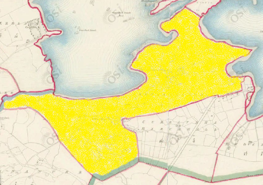
Size: 244 acres , 0 rods , 21 perchs
Siting:
Situated in the northern extremity of Kilcummin parish. Bounded on the north by Ard and Lough Corrib; on the north-west by Annaghkeelaun and Knockkillaree; on the west by Aughnanure and on the south by Birchhall and the parish of Killannin.
Description:
Very good but very rocky land full of bushes. Contains 244 acres all arable with the exception of 50 acres of bog. There is a Gentleman’s Seat (situated close to its western boundary) called after the townland.
Placenames within townland:
Baurnahardia (point) – A point jutting out into the lake. Translates to “top of the height/hill”.
Grass Bush I No. 1 (island) – A small island on Lough Corrib comprised of rough grass, bushes and rocks. It lies to the south of Grass Bush I. No. 2.
Grass Bush No. 2 (island) – A small island on Lough Corrib covered with rough grass and bushes. It is situated to the north of Grass Bush Island I No. 1.
Grass Bush No. 3 (island) – A small island on Lough Corrib comprised of rough grass and bushes and containing ½ acre which lies west of Illaunacoppul. There are two rocks which lie west of this island also.
Moor Island No. 2 (island) – Island on Lough Corrib containing 1¾ acres of sandy pasture, situated south of the Eagle Islands and east of Moor Island No. 3.
Moor Island No. 3 (island) – Island on Lough Corrib containing 2 acres of rough pasture situated west of Illaunfaddmore.
Mullagh Ardnasillagh (hill) – A high hill located in northern section of townland near the shores of Lough Corrib It has a triangulation station on it on the north side of a lane. Translates to “summit of the hill of the sally trees”
Previous proprietor/landlord:
Richard Martin (1670)
Earl of Clanrickard (1670)
Arthur French St. George of Tyrone House (c. 1850)
Land Value (1857): £ 127 s. 14 d. 0
Buildings Value (1857): £ 3 s. 8 d. 0
Surnames attached to the townland (1857-1911):
O’Flaherty, Joyce, Halloran, Lydon, Murray, Molloy, Walsh, Kelly, Murry, Conneely, Melia, Mogan, Welby, Lee


No Comments
Add a comment about this page