Rinneroon
Text - Mary Kyne, Hyperlinks - Antoinette Lydon


Rinnerroon is in the civil parish of Kilcummin. The civil Parish corresponds with the following Church of Ireland parish of Kilcummin, Galway West. In general, the civil parish and the Church of Ireland parish are the same as is the case in the Kilcummin Oughterard area.
Rinnerroon is in the Electoral Division of Letterfore, in Civil Parish of Kilcummin, in the Barony of Moycullen, in the County of Galway
Irish Form of Name: Rinn Eiremhoin
Translation: Heremon’s Point
Parish: Kilcummin
View all place names in this civil parish.
Other Forms of the Name with the authority source (if provided) in italics.
Rinnerroon
Rinn Eiremhoin
Rin Eiremhan
Recte Rinn-Erwin
Rinaroon Boundary Surveyor
Rienerune Barony Cess Book
Rienerew County Map
Rineroon Local
Rinerroon Rector of Kilcummin
Reinarrew Barony Map
Comment: Rinerr [crossed out]
Description:
Land good and dry, 2 holdings 2 families. Contains 72 ¾ acres all arable with the exception of 10 acres of bog. There is a neat house situate near its western boundary.
Situation:
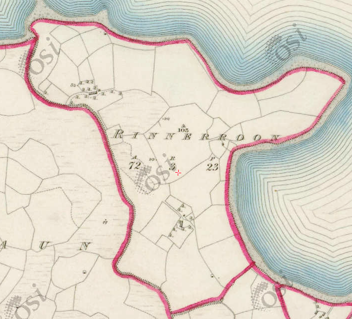
Situate in the northern extremity of the parish. Bounded on the N.and E. by Lough Corrib, on the W. by Farrawaun and on the S. by Gortaroola townlands.
Rinnerroon borders the following other townlands:
- Farravaun to the west
- Gorterwulla to the south
Information from Joyce’s Place Names
Translation according to P. W. Joyce
Rinnerroon in Galway; Rinn-Ereamhoin, Ere-mon’s or Irvine’s or Harmon’s point.
Landlord:
Arthur Ffrench, Esq., Tyrone.
Arthur French St. George of Tyrone House
Information on the owner’s family from the Landed Estates Database;
Arthur French St. George is a member of the St George (Tyrone) family.
- St. George (Tyrone House) – The St.George estate was centred on the house at Tyrone, parish of Drumacoo, barony of Dunkellin, built about 1779. This had originally been a French estate but the family assumed the title of St.George in 1774 due to inheritance from the St.George family of Hatley Manor, county Leitrim. In the 1830s A.F. St. George owned Tyrone House and Kilcolgan Castle, his agent was J. O’Hara. Wm. Griffith of Dublin also acted as an agent for the St. George estate. Arthur French St. George is described as a resident proprietor in 1824. In the early 19th century the St. Georges also owned large amounts of land in the baronies of Moycullen, Ballynahinch and Clare, which they advertised for sale in the early 1850s. Land in the barony of Clare had been acquired through Arthur French’s marriage with a Kirwan in the late 17th century. A portion of the St. George estate, situated in the barony of Longford, was offered for sale in the Encumbered Estates court in November 1853. In 1870s the family owned 15,777 acres in county Galway. By the early 1900s, however, some of the estate had been sold and the house at Tyrone had been left empty for long periods. In 1914 over 3000 acres of an estate described as St. George and Concannon was vested in the Congested Districts Board. Many members of the family are buried in a church-style mausoleum in the cemetery at Drumacoo.
Information from the Down Survey Website:
The Down Survey is a mapped survey. Using the Civil Survey as a guide, teams of surveyors, mainly former soldiers, were sent out under Petty’s direction to measure every townland to be forfeited to soldiers and adventurers. The resulting maps, made at a scale of 40 perches to one inch (the modern equivalent of 1:50,000), were the first systematic mapping of a large area on such a scale attempted anywhere. The primary purpose of these maps was to record the boundaries of each townland and to calculate their areas with great precision. The maps are also rich in other detail showing churches, roads, rivers, castles, houses and fortifications. Most towns are represented pictorially and the cartouches, the decorative titles, of each map in many cases reflect a specific characteristic of each barony. (http://downsurvey.tcd.ie)
Townland of RINNERROON
Down Survey Name: Renneron
1641 Owner(s): Clanrickard, Earl of (Protestant)
1670 Owner(s): Martin, Richard (Catholic)
County: Galway
Barony: Muckullin
Parish: Killcumyn
Unprofitable land: 32 plantation acres
Profitable land: 6 plantation acres
Forfeited: 6 plantation acres
The Down Survey website will tell you who owned this townland in 1641 (pre Cromwell) and in 1671 (post Cromwell).
The Tithe Applotment Books:
About the Records
Tithes were a tax on agricultural produce which was payable by the occupiers of agricultural land. They were the main source of income for the parish clergy of the Church of Ireland (the largest Protestant church and the church established by law). However, in many parishes a large part of the tithes were ‘appropriate’, which meant that they were payable to a bishop, cathedral chapter or other ecclesiastical recipient, or were ‘impropriate’, which generally meant that they were payable to a local landowner. The parishes used in the Tithe Applotment Books are civil or Church of Ireland parishes, which often differ in name and territory from Catholic parishes, Acts of Parliament of 1823 and 1832 provided for the conversion of tithes into a fixed charge on land, and specified the average price of wheat or oats in the parish in the seven years before 1821 as the basis on which the tithes would be calculated. They also extended the application of tithes to pasture, where previously they had been levied only on tillage.
This change in the law resulted in the valuation of individual holdings in almost all parishes containing agricultural land, in order to assess the portion of the tithes for which each occupier of land would be liable. The apportionment was recorded for each Church of Ireland parish in a Tithe Composition Applotment Book. The information was collected and the amounts were calculated by two Parochial Commissioners, one of whom was appointed by the cess-payers of the parish and the other by the relevant Diocese of the Church of Ireland. This procedure was carried out in over 2,500 parishes between the years 1823 and 1837.
The Tithe Applotment Books are in a variety of formats, from a few pages sewn together to elaborately bound volumes. In most cases they are written in manuscript throughout, although some consist of manuscript entries on printed questionnaires. The information in the books is broadly uniform and generally includes at least the name of occupier; the size of holding, the valuation and the tithe payable. In some cases, more detailed information is provided. Some volumes have maps and most have certificates and correspondence attached.
The sub-divisions of the parish were recorded. Some of these subdivisions, such as ploughlands, ceased to be in official use after the six-inch survey of the Ordnance Survey was completed in the 1840s. Only productive land was subject to tithe, and the books usually distinguish between this tithable land and untithable land such as roads or mountains. Tithable land was in some cases classified by quality, and a money value was given to each class. In some cases, the proportion of tithe payable to the rector, vicar or lay proprietor of the tithes was set out. The column for observations was sometimes completed, with information about commonage, for example.
There are a number of other points that should be noted. The acreages given in the Tithe Applotment Books are in Irish or Plantation measure, which is 1.62 times larger than statute measure. Only occupiers of land at the time of the tithe composition are recorded, so not all heads of households living in a parish at the time are included. Only rural areas are systematically covered, although inhabitants of towns who held plots of cultivable land are included. The equivalent tax in urban areas, Minister’s Money, has left few records.
The Tithe Applotment Books are an important source of information for a wide variety of researchers of pre-Famine Ireland. They provide the first surviving national list of the occupiers of land, and are used by genealogists as a partial substitute for returns of the 1821 and 1831 censuses of population, which were destroyed in 1922. They also record information on the quality of land, and provide information on pre-Ordnance Survey territorial divisions, some of which were not recognised after the 1840s.
The National Archives hold the original Tithe Applotment Books only for the twenty-six counties of the Republic of Ireland. The books for the six counties of Northern Ireland are held in the Public Record Office of Northern Ireland in Belfast.(http://titheapplotmentbooks.nationalarchives.ie/search/tab/aboutmore.jsp)
Tithes Applotment – Rinnerroon No information found.
Griffiths Valuation
In Griffith’s Valuation the area was 72 acres, 3 rood & 23 perch of land. The valuation of the land was £21 0s 0d, Buildings £1 10s 0d. Total £22 10s 0d.
Occupiers
William Allen & John Sullivan.
Immediate Lessor
Kennedy
http://www.askaboutireland.ie/griffith-valuation/index.xml?action=doNameSearch&PlaceID=559063
Out Offices and Land
The out office was a farm building, a cow house, piggery or barn. The land was very poor and sterile and people were always poverty-stricken. At this time most tenants were trying to eke out a living on 5 acres or less and a farmer needed at least 15.3 acres to survive.
Poor Law Union Ireland
In Ireland the Poor Relief Act of 1838 divided into districts or “unions” in which the local taxable inhabitants were to be financially responsible for all paupers in the area. In 1898 the Poor Law Union was adopted as the basic administrative division in place of the civil parish and barony. Further subdivision into 828 registration districts and 3,751 district electoral divisions followed. Townlands were not arranged according to these divisions with parish and barony retained as a means to make comparisons with records gathered before 1898.
The 1838 Act
The main provisions of the 1838 Act were:
- The extension of the existing Poor Law Commissioners’ powers to Ireland, with the appointment of Assistant Commissioners who were to implement the Act in Ireland.
- The division of the country into Poor Law Unions based on Irish electoral divisions which were themselves made up from townlands.
- The creation of a Board of Guardians for each Union, two-thirds of whom were to be elected, the other third to be appointed ex officio.
- The setting up of a workhouse in each Union.
- The collection of a local poor-rate to finance the system.
- Assistance for emigration.
Initially, 130 Unions were created, based upon 2,049 electoral divisions. The divisions were composed of townlands, a peculiarly Irish unit, traditionally of 120 Irish acres in area. (Between 1848 and 1850, an additional 33 Unions were created by subdividing and reorganizing the boundaries of some existing Unions, particularly in the west of the country.
Boards of Guardians were elected annually on 25th March. Only rate-payers were eligible for election, which effectively disenfranchised most of the native Irish who were usually tenants at this time. Rate-payers were allowed between one and six votes depending on the size of a valuation of their property.
What is a townland?
A townland is one of the smallest land divisions in Ireland. They range in size from a few acres to thousands of acres. Many are Gaelic in origin, but some came into existence after the Norman invasion of 1169. Rinnerroon is a townland.
Population and Census Information
People who lived here:
You can retrieve a list of people who lived in this townland from 1827 to 1911. This list is compiled from the following resources.
- The Tithe Applotment Books
- Griffith’s Valuation
- 1901 Census
- 1911 Census
List of nineteenth century and early twentieth century inhabitants.
Census 1841-1891
1841 – 3 houses with 20 people
1851 – 3 houses with 16 people.
1861 – 2 houses with 4 people.
1871 – 1 houses with 3 people.
1881 – 1 house (1 male, 2 females) with 1 outbuilding. The valuation of Houses & Land in 1881 was £22 10s 0d.
1891 1 house (2 males, 1 female1) with 4 outbuildings. The valuation of Houses & Land in 1881 was £22 10s 0d.
1901 Census
This is a return of the member of the family, their Visitors, Boarders, and Servants who slept or abode in their house on the night of 31st of March 1901 in Rinnerroon. There were 2 houses listed in the townland of Rinnerroon. Of the people living in Rinnerroon, 3 were Roman Catholics.
All 3 People were born in Co. Galway.
There were a total of 1 farm building and out offices which was a cow houses.
Class of House: The class of house depended on the materials used in the roof, walls, number of rooms and number of front windows. A 1st class house was considered the highest standard.
Walls of the houses: The walls were of stone, brick, and concrete or of mud, wood or other perishable material. The house in Rinnerroon was built of stone, brick or concrete. There were no mud cabins.
House Occupancy: 2 Houses were occupied on the night of the Census.
Enumerators Extract
http://www.census.nationalarchives.ie/reels/nai000840423/
House & Building Return
http://www.census.nationalarchives.ie/reels/nai000840425/
Return of Out Office & Farm Steading
http://www.census.nationalarchives.ie/reels/nai000840426/
House 1
Matthew Joyce aged 37 was the head of the family, married to Julia aged 25.
Matthew was a farmer. Matthew & Julia could read and write and could spoke Irish & English.
They lived in a 3rd class house with 2 rooms and 1 front window. They had one cow house.
http://www.census.nationalarchives.ie/pages/1901/Galway/Letterfore/Rinnerroon/1394510/
House 2
Thomas Joyce aged 40 was head of the family, single he lived alone.
Thomas was a farmer; he could not read; he spoke Irish & English.
He lived in a 3rd class house with 1 room and 1 front window. He had no outbuildings.
http://www.census.nationalarchives.ie/pages/1901/Galway/Letterfore/Rinnerroon/1394511/
Census 1911
This is a return of the Members of the families in Rinnerroon, their visitors, boarders and servants who slept or abode in the house on the night of Sunday 2nd April 1911.
There were 2 houses listed in the Townland of Rinnerroon. A total of 8 (5 males/3 females) living in Rinnerroon, all were Roman Catholic.
People that lived in Rinnerroon were born included Co. Galway. There was 1 farm building a cow house.
Enumerators Extract
http://www.census.nationalarchives.ie/reels/nai002435044/
House & Building Return
http://www.census.nationalarchives.ie/reels/nai002435046/
Return of Out Office & Farm Steading
http://www.census.nationalarchives.ie/reels/nai002435048/
House 1
Matthias Joyce aged 40 was the head of the family, married to Julia aged 36. They lived with their children John aged 9, Thomas aged 7, Mary aged 4 & Michael aged 2.
Matthias was a farmer. John & Thomas were scholars. Julia could read and write and could spoke Irish & English. Matthias, John & Thomas could not read; they spoke Irish & English. Mary & Michael could not read.
Matthias & Julia were married for 10 years; they had 5 children with all with all 5 living at the time of the census (but there are only 4 children listed on the census).
They lived in a 3rd class house with 2 rooms and 2 front windows. They had one cow house.
http://www.census.nationalarchives.ie/pages/1911/Galway/Letterfore/Rinnerroon/912204/
House 2
Thomas Joyce aged 35 was head of the family; he lived with his sister Mary aged 37, both single.
Thomas was a farmer. Thomas & Mary could read & write; they both spoke Irish & English.
They lived in a 3rd class house with 2 rooms and 1 front window. They had no outbuildings.
http://www.census.nationalarchives.ie/pages/1911/Galway/Letterfore/Rinnerroon/912205/
Church records of births, deaths and marriages:
Church records of births, deaths and marriages are available online at http://www.rootsireland.ie. To search these records, you will need to know the ‘church parish’ rather than the ‘civil parish’. (The civil parish is the pre-reformation parish and was frequently used as a unit of administration in the past.)
Rinnerroon is in the civil parish of Kilcummin.
Catholic parish:
This civil parish corresponds with the following Roman Catholic parish or parishes.
- Clonbern & Kilkerrin in Galway East.
- Carraroe in Galway West.
- Kilannin in Galway West.
- Kilcummin/Oughterard in Galway West.
- Rosmuc in Galway West.
Church of Ireland parish:
This civil parish corresponds with the following Church of Ireland parish.
- Kilcummin in Galway West.
In general, the civil parish and the Church of Ireland parish are the same, but, this is not always the case.
Maps:
It is located at 53° 28′ 45″ N, 9° 22′ 43″ W.
Original OS map of this area
Ireland was first mapped in the 1840s. These original maps are available online.
Original OS maps at the Ordnance Survey of Ireland website
Below is a link to the Ordnance Survey of Ireland website. It displays the original OS map that was created in the 1840s.
Information from Google Maps:
You can use this link to find this townland on Google Maps.
Information from the National Monuments Service:
You can use this link to view a map of archaeological features. This link brings you to a website wherein you will have to search for your townland.
Archaeological map from the National Monuments Service
Townlands.ie Website
http://www.townlands.ie/galway/moycullen/kilcummin/letterfore/rinnerroon/
Galway Library Website
http://places.galwaylibrary.ie/asp/fullresult.asp?id=53043
Rinneroon, which is a sandy peninsula on the lakeshore, lies west of Gorterwulla. Some of the areas finest meadows are to be found here overlooking the Lake as are some of the areas finest real estate properties all with lake frontage – not to mention some of the lakes best fishing spots that lie close by.
In the sixties Mick and Thomas farmed the land in Rinneroon. It is now owned and farmed by Eamon King of Farravaun.
1960’s In the early sixties, Dermot Joyce, an Oughterard business man bought the Rinneroon peninsula from Mick Joyce. He employed Paddy Clancy from Farravaun as the builder. The first house to be built was for Bill and Molly Nevin. Molly has passed away. Bill and his friend Mary still visit Glann. Paddy continued to build and while the third was being built Padhraig Faherty Oughterard erected one for Jack Touhy a former owner of the Zetland Hotel Cashel.
In 2013, there are ten houses in this townland. The oldest of these is occupied by Elizabeth King and her husband Kevin McEntyre. Elizabeth is Eamonn King’s daughter. The house they occupy
was renovated by Mick and Thomas Joyce where the old family home stood. The other nine houses have been built since the 1960s.
2013 Occupants: As one goes down the road, the present owners, starting on the left hand side are Aengus and Sheila McCarthy, Paul and Susan Horan, Jim and Rosemary Sheehan, James and Colleen Burns, Stephen and Andra Hone, Tony and Delia Barry, Bill and Mary Nevin, John and Maxine Dolan and the last house to be built was for David Griffin.
The former owners of the Hone residence were Owen and Una O’Malley. Owen pioneered open heart surgery in Ireland and Una was the youngest daughter of Kevin and Brigid O Higgins. Kevin was the first minister for Justice in the Irish Free State. Una made a great contribution to Irish life and was a tireless worker for tolerance, forgiveness and reconciliation.
The following poem published in her collection, ‘Twentieth Century Revisited’ shows her sense of fun.
THE RURAL TIGER
I face four very doubtful cattle-grids
Bent by the weight of trucks of nearby builders
and take the upper road, known as the scenic route
(though the lower one is likewise beautiful)
I pick my way along the puddled potholes
which make a mockery of last years improvements;
and pray I will not meet the foresters
double-articulated lorry nor the garbage truck
nor any other great ‘long vehicle’
and that the low slung winter sun won’t blind my eyes
as I negotiate that awkward bend,
and that the collie dog won’t mount an angry protest
as I pass the Fairy Bridge, nor the fatuous cattle,
stand munching in the roadway,
nor small boy seek his errant ball
out from between the bushes
as I approach the Senior School, hoping the students
will have parked their L-plate cars and motor-bikes
before I get there.
I wiggle across the uphill twisted bridge weaving between
Bus Eireann and the giant JCB’s
engaged in knocking down the convent
– (thus making room for twelve luxury apartments) –
and the panting euro lorries
pounding their way to Connemara.
At last I reach the newsagent and gather up my paper –
‘Isn’t the Dublin traffic terrible?’ they say ‘Your so much
safer in the country’.
If one takes either of the newly constructed gravel roads built by Eamonn King you come across the stone ruins of two old adjacent houses nestling in the shelter of the raised fields facing south. The first was last occupied by Tom and Mary Joyce – brother and sister. In the other house was their brother Matt who married Julia Walsh from Dooras. They were the parents of Mick and Thomas, John, Mary, and Patrick. They built the house which Mick and Thomas later renovated.
Last Burial at Inchagaill
Julia died in 1944. She was the last person from Glann to be buried on Inchagoill. The day of the funeral was cold, wet and squally. Walter Butler’s Púcan brought the coffin to the island and a cortège of boats followed. The sail on the Púcan was torn, but Walter and Christy managed to bring it back to Currarevagh after the burial and that was its last resting place. Sadly, her son John had a cold on the day and developed pneumonia. He died as a result and at his own request is buried in Faughnacille. The previous occupants of Tom and Mary Joyce’s house were the family of William Allen mentioned above. The adjoining house to the west was occupied by John Sullivan. Tom Joyce’s nick-name was ‘Jingles’ and to this day the point on the lake to the north of their home is known as Jingles Point. It used to be a ‘deadly’ place for a salmon.
Just a last little picture of Rinneroon. When Matt and Julia’s family were in their teens and early twenties John was a great organiser. The fields were fairly at and extensive and he organised Pony Races Sports and bicycle races on a regular basis.
Mary Kyne


Comments about this page
There is a house missing in your list of houses and owners on Rinneroon.
We have owned and occupied this house right at the point of Rinneroon between the Sheehans and Hones.
We are James and Colleen Burns who have owned and occupied this house since 1996.
We first leased and occupied the house in 1995 and then purchased it in 1996.
I am the owner of Angus and sheila Mc Carthy’ house
since 2014.
When I bought that house I read on Irish time dated june 20, 2013 that house have been owned by Joe Mc Grath’s family .( his daughter ? ) . Joe Mc Grath the famous and
controversial irish politic ( twice minister ) and businessman who owned hospital irish sweepstake, waterford glass and many many other firms.
Can you confirm that
Best regards
Add a comment about this page