Portacarron
Text Treasa NicDhonncha & Hyperlinks Antoinette Lydon


Portacarron is in the civil parish of Kilcummin. The civil parish corresponds with the following Church of Ireland parish of Kilcummin, Galway West. In general the civil parish and the Church of Ireland parish are the same as is the case in the Kilcummin Oughterard area.
Irish Form of Name: Port a’ Charraoin
Translation: park of the water pail
Portacarron is in the Electoral Division of Oughterard, in Civil Parish of Kilcummin, in the Barony of Moycullen, in the County of Galway
Translation according to P.W. Joyce’s Place Names :
Port, a bank, a landing-place, a fortress. To be interpreted according to circumstances.
O’Donovan’s Field Name Books
Other Forms of the Name:
Portacarron
Port a’ Charraoin
Port a’ charraoin
Portacarron Boundary Surveyor
Portcarren Barony Cess Book
Portcarron County Map
Portacarron Local
Portacarus
Description:
Proprietor John Nolan, Ballinderry, let to tenants who occupy the House of Portacarron. Land very good. Contains 233¾ acres, but 120 acres under tillage and pasture, the remainder bog and a few patches of plantation and brushwood . Portacarron House situated in the northern part of this townland, also an old mound or fort with ruins forms part of the shore of Lough Corrib.
Situation:
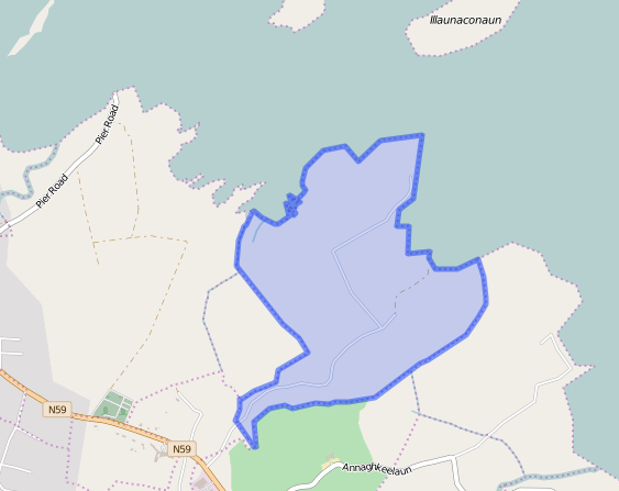
Situated in the northern extremity of the parish. Bounded on the N. by Lough Corrib, on the E. by Annagh Keelann, on the W. by Portacarronbeg and Rushweela and on the S. by Gurtreavagh townlands.
Proprietor:
John Nolan of Ballinderry, Co. Galway.
John Nolan is a member of the Nolan (Ballinderry) family.
Landed Estates Database:
Nolan (Ballinderry) – The Nolans were Elizabethan settlers in the Ballinrobe area of county Mayo. They lost most of their estate in county Mayo to the Cuffs during the Commonwealth and were transplanted to Ballinderry in the parish of Cummer, barony of Clare, county Galway. A notebook in the National Library contains a copy of a patent dated 20 Aug 1677 which refers to the Nolan interest in lands in the baronies of Kilmaine, Clanmorris and Gallen, county Mayo and in the baronies of Clare, Dunmore and Ballymoe, county Galway. At the time of Griffith’s Valuation their estate at Ballinderry was mainly in the parish of Cummer but also included townlands in the parishes of Annaghdown and Belclare and the Nolans still had 2 townlands in the parish of Kilcommon and 2 townlands in the parish of Kilmainebeg, barony of Kilmaine, county Mayo. A volume in the Kirwan of Dalgin collection traces the early generations as Patrick Nolan who married Anne Browne in 1667, John married Ellis Brabazon in 1709, Patrick married a Martin of Tulira. Through a late 18th century marriage with Margaret the daughter and heiress of James French of Portacarron, parish and barony of Moycullen, county Galway, an estate in that district came into the possession of John Nolan, son of Patrick. In 1809 their son John Nolan married Mary Browne daughter of John Browne of Castlemoyle. Mary Anne Nolan, widow of John Nolan of Ballinderry and herself a Nolan of Lugboy, county Mayo, held townlands and islands in the parishes of Moyrus, Kilcummin and Killannin in the barony of Moycullen at the time of Griffith’s Valuation. She and her husband had 6 sons of whom John Philip Nolan was a Member of Parliament for county Galway for much of the later part of the 19th century. Burke’s ”Landed Gentry of Ireland” records that J.P. Nolan’s younger brother Walter Raymond Nolan was heir to his maternal grandfather. Sebastian Nolan, a very wealthy bachelor, lived at Castlemoyle and later at Seamount, Salthill. Philip John Nolan was the only one of the brothers to marry. In the 1870s the estate amounted to 6,866 acres with an additional 800 acres in county Mayo. Walter M. Nolan of the Army and Navy Club, London owned 1852 acres in county Galway in the 1870s. The records of the land agents Denis J. Kirwan and Sons contain late 19th century records relating to the estate of Colonel W.R. Nolan in the parishes of Kilquain and Killimorbologue, barony of Longford, Annaghdown and Belclare, barony of Clare, Monieva, barony of Tiaquin and Dunmore, barony of Ballymoe.
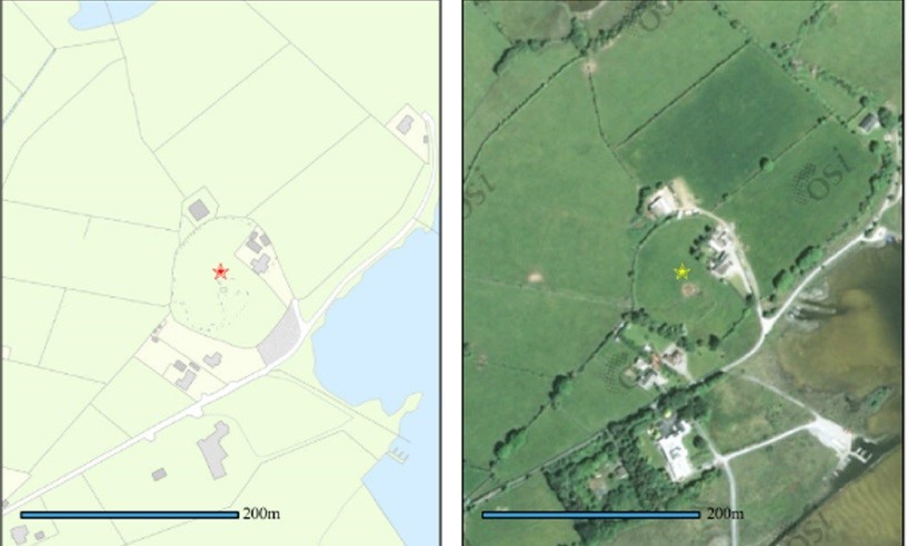
Information from the National Monuments Service:
- Sites and Monuments Number: GA054 – 061001
ITM Reference: (E, N): 514687, 743363
Irish Grid Reference (E, N): 114718, 243338
Class: Ecclesiastical Enclosure
Townland: Portacarron
Description: Close to W shore of Lough Corrib. A large oval enclosure (E-W 94.6m; N-S 65.2m) defined by an earth and stone bank, best preserved at S (Wth 2m; H 0.7m) but disturbed elsewhere by farm buildings and modern walls. A small D-shaped enclosure (20.5m by 11.2m), in S half of interior, contains a church (GA054-061003-). No visible trace survives of the bullaun mentioned by Kinahan (1868a, 77) as lying to S of it, or of the ‘Mound (Site of)’ shown on OS 6-inch map to NW. (Killanin 1947, 124)
The above description is derived from the published ‘Archaeological Inventory of County Galway Vol. I – West Galway’. Compiled by Paul Gosling (Dublin: Stationery Office, 1993).
- Sites and Monuments Number: GA054 – 061002
ITM Reference: (E, N): 514687, 743364
Irish Grid Reference (E, N): 114718, 243339
Class: Enclosure
Townland: Portacarron
- Sites and Monuments Number: GA054 – 061003
ITM Reference: (E, N): 514685, 743355
Irish Grid Reference (E, N): 114716, 243330
Class: Church
Townland: Portacarron
Description: In S half of an early ecclesiastical enclosure (GA054-061001-). Small, much-ruined E. Chr. oratory (E-W; L c. 6.25, Wth c. 3m). No architectural features are visible nor is there any trace of the doorway noted in W wall by Kinahan (1868a, 77). (Killanin 1947, 124)
The above description is derived from the published ‘Archaeological Inventory of County Galway Vol. I – West Galway’. Compiled by Paul Gosling (Dublin: Stationery Office, 1993).
- Sites and Monuments Number: GA054 – 061004
Class: Bullaun Stone
Townland: Portacarron
Precise location for this record is unknown.
- Sites and Monuments Number: GA054 – 061005
ITM Reference: (E, N): 514676, 743373
Irish Grid Reference (E, N): 114707, 243348
Class: mound
Townland: Portacarron
Down Survey
The Down Survey is a mapped survey. Using the Civil Survey as a guide, teams of surveyors, mainly former soldiers, were sent out under Petty’s direction to measure every townland to be forfeited to soldiers and adventurers. The resulting maps, made at a scale of 40 perches to one inch (the modern equivalent of 1:50,000), were the first systematic mapping of a large area on such a scale attempted anywhere. The primary purpose of these maps was to record the boundaries of each townland and to calculate their areas with great precision. The maps are also rich in other detail showing churches, roads, rivers, castles, houses and fortifications. Most towns are represented pictorially and the cartouches, the decorative titles, of each map in many cases reflect a specific characteristic of each barony. (http://downsurvey.tcd.ie)
Down Survey Information on Portacarron
Down Survey Name: Portcarry
1641 Owner(s): Darcy, Peter (Catholic)
1670 Owner(s): Bingham, Sir George (Protestant)
County: Galway
Barony: Muckullin
Parish: Killcumyn
The Down Survey website will tell you who owned this townland in 1641 (pre Cromwell) and in 1671 (post Cromwell).
The Tithe Applotment Books
About the Records
Tithes were a tax on agricultural produce which was payable by the occupiers of agricultural land. They were the main source of income for the parish clergy of the Church of Ireland (the largest Protestant church and the church established by law). However, in many parishes a large part of the tithes were ‘appropriate’, which meant that they were payable to a bishop, cathedral chapter or other ecclesiastical recipient, or were ‘impropriate’, which generally meant that they were payable to a local landowner. The parishes used in the Tithe Applotment Books are civil or Church of Ireland parishes, which often differ in name and territory from Catholic parishes,
Acts of Parliament of 1823 and 1832 provided for the conversion of tithes into a fixed charge on land, and specified the average price of wheat or oats in the parish in the seven years before 1821 as the basis on which the tithes would be calculated. They also extended the application of tithes to pasture, where previously they had been levied only on tillage.
This change in the law resulted in the valuation of individual holdings in almost all parishes containing agricultural land, in order to assess the portion of the tithes for which each occupier of land would be liable. The apportionment was recorded for each Church of Ireland parish in a Tithe Composition Applotment Book. The information was collected and the amounts were calculated by two Parochial Commissioners, one of whom was appointed by the cess-payers of the parish and the other by the relevant Diocese of the Church of Ireland. This procedure was carried out in over 2,500 parishes between the years 1823 and 1837.
The Tithe Applotment Books are in a variety of formats, from a few pages sewn together to elaborately bound volumes. In most cases they are written in manuscript throughout, although some consist of manuscript entries on printed questionnaires. The information in the books is broadly uniform and generally includes at least the name of occupier; the size of holding, the valuation and the tithe payable. In some cases more detailed information is provided. Some volumes have maps and most have certificates and correspondence attached.
The sub-divisions of the parish were recorded. Some of these subdivisions, such as ploughlands, ceased to be in official use after the six inch survey of the Ordnance Survey was completed in the 1840s. Only productive land was subject to tithe, and the books usually distinguish between this tithable land and untithable land such as roads or mountains. Tithable land was in some cases classified by quality, and a money value was given to each class. In some cases the proportion of tithe payable to the rector, vicar or lay proprietor of the tithes was set out. The column for observations was sometimes completed, with information about commonage, for example.
There are a number of other points that should be noted. The acreages given in the Tithe Applotment Books are in Irish or Plantation measure, which is 1.62 times larger than statute measure. Only occupiers of land at the time of the tithe composition are recorded, so not all heads of households living in a parish at the time are included. Only rural areas are systematically covered, although inhabitants of towns who held plots of cultivable land are included. The equivalent tax in urban areas, Minister’s Money, has left few records.
The Tithe Applotment Books are an important source of information for a wide variety of researchers of pre-Famine Ireland. They provide the first surviving national list of the occupiers of land, and are used by genealogists as a partial substitute for returns of the 1821 and 1831 censuses of population, which were destroyed in 1922. They also record information on the quality of land, and provide information on pre-Ordnance Survey territorial divisions, some of which were not recognised after the 1840s.
The National Archives hold the original Tithe Applotment Books only for the twenty-six counties of the Republic of Ireland. The books for the six counties of Northern Ireland are held in the Public Record Office of Northern Ireland in Belfast. (http://titheapplotmentbooks.nationalarchives.ie/search/tab/aboutmore.jsp)
Tithe Applotment Record for Portcarron
Landholders
Listed in the Tithe Applotment book for Portacarron in 1829 is;
Francis French Esq.
Land Liable for Tithe
The total land liable for tithes in Portacarron was 129 acres, 2 roods. This was divided into five separate columns according to the quality of land.
- 30 acres of 1st rate quality land with a tithe of 1s 6d per acre.
- 40 acre of 2nd rate quality land with a tithe of 1s per acre.
- 20 acres of 3rd rate quality land with a tithe of 3d per acre.
- 7 acres of 4th rate quality land with a tithe of ½ d per acre.
- 32 acres and 2 roods of 5th rate quality land with a tithe of 1/8 d per acre.
Tithes Payable
The proportion of tithes payable to Richard Martin Esq. was £2 5s, 3 3/4d, the proportion of tithes payable to Reverend James Daly was £1 2s 7 1/2d, and the proportion of tithes payable to Reverend John Wilson was £1 2s 7 1/2d
Griffith’s Valuation 1850s
In Griffith’s Valuation the area is 233 acres 12 roods and 37 perches with a land value of £76 10s 0d and a building value of £5 16s 0d with a total value of £86 6s 0 d.
Occupiers of the Land:
The occupiers of the land at this time were: John Mealy, Thomas Mealy, William Small, Joseph Healy, Joseph Healy, William Small, John Mealy, Michael Healy, Thomas Healy, Thomas Healy, Michael Gorman, Michael Fahy, Thomas Fahy, Michael Fahy, Thomas Fahy, John Mealy and Tenants of Townland.
The Landlord or immediate leasers was Marianne Nolan.
Ownership of Land and Property
John Mealy, Thomas Mealy, William Small and Joseph Healy owned bog land totalling 26 acres 2 roods and 26 perches. Joseph Healy and Michael Fahy each owned a house, offices and land. William Small, Thomas Mealy, Michael Healy, Thomas Healy, Thomas Healy, Michael Gorman and Thomas Fahy each owned a house and land. Michael Fahy and Thomas Fahy each owned land. John Mealy owned a house and offices. The Tenants of the Townland owned bog land of no value totalling 44 acres 3 roods and 35 perches.
Annual Valuation
The total annual valuation of rateable property in Portacarron came to £86 6s 0d.
Land Rates: John Mealy, Thomas Mealy, William Small and Joseph Healy each paid 1s for bog land. John Mealy paid £18. Joseph Healy and William Small each paid £5. Michael Fahy paid £12. Thomas Mealy paid £9. Michael Healy, Thomas Healy and Thomas Fahy each paid £6. Thomas Healy and Michael Gorman each paid £4 10s. Michael Fahy paid £4. Thomas Fahy paid 2s.
Building Rates: Michael Fahy paid £1 6s. Joseph Healy, William Small, Thomas Mealy, Michael Healy, Thomas Healy, Thomas Healy, Michael Gorman, Thomas Fahy and John Mealy each paid 10s.
http://www.askaboutireland.ie/griffith-valuation/index.xml?action=doNameSearch&PlaceID=560148
Out Offices and Land
The out office was a farm building, a cow house, piggery or barn. The land was very poor and sterile and people were always poverty-stricken. At this time most tenants were trying to eke out a living on 5acres or less and farmers needed at least 15.3 acres to survive.
Poor Law Union Ireland
In Ireland the Poor Relief Act of 1838 divided into districts or “unions” in which the local taxable inhabitants were to be financially responsible for all paupers in the area. In 1898 the Poor Law Union was adopted as the basic administrative division in place of the civil parish and barony. Further subdivision into 828 registration districts and 3,751 district electoral divisions followed. Townlands were not arranged according to these divisions with parish and barony retained as a means to make comparisons with records gathered before 1898.
The 1838 Act
The main provisions of the 1838 Act were:
- The extension of the existing Poor Law Commissioners’ powers to Ireland, with the appointment of Assistant Commissioners who were to implement the Act in Ireland.
- The division of the country into Poor Law Unions based on Irish electoral divisions which were themselves made up from townlands.
- The creation of a Board of Guardians for each Union, two-thirds of whom were to be elected, the other third to be appointed ex officio.
- The setting up of a workhouse in each Union.
- The collection of a local poor-rate to finance the system.
- Assistance for emigration.
Initially, 130 Unions were created, based upon 2,049 electoral divisions. The divisions were composed of townlands, a peculiarly Irish unit, traditionally of 120 Irish acres in area. (Between 1848 and 1850, an additional 33 Unions were created by subdividing and reorganizing the boundaries of some existing Unions, particularly in the west of the country.
Boards of Guardians were elected annually on 25th March. Only rate-payers were eligible for election, which effectively disenfranchised most of the native Irish who were usually tenants at this time. Rate-payers were allowed between one and six votes depending on the size of a valuation of their property.
Townlands
A town land is one of the smallest land divisions in Ireland. They range in size from a few acres to thousands of acres. Many are Gaelic in origin, but some came into existence after the Norman invasion 1169. Portacarron is a townland and other place names in or near this townland are:
- Cussafoor Island
Irish Form of Name: Cosa Fuara. Translation: cold legs or feet.
Other Forms of the Name are; Cussafoor Island, Cosa Fuara , Cussafoor Island Boundary Surveyor, Cushafore County Map, Cussafoor Island or cold footed Island Local, Cushafore Barony Map. Contains 1¼ acre, all under rough pasture and brushwood – situated nearly N. of Innishhool and S.E. of Urkannbeg Island. Situated in Lough Corrib, it belongs to the townland of Portacarron.
- Inishbeagh
Irish Form of Name: Inis Beitheach. Translation: birch island
Other Forms of the Name; Inishbeagh, Inis Beitheach, Innishbeagh Boundary Surveyor, Innisbeagh County Map, Innishbeagh or Birch Island Local, Innishbeigh Barony Map. Contains 4 acres, all under tillage with a few scattered bushes – situated nearly off Bilberry Island. Situated in Lough Corrib, it belongs to the townland of Portacarron.
Population & Census Information
People who lived here:
You can retrieve a list of people who lived in this townland from 1827 to 1911. This list is compiled from the following resources.
- The Tithe Applotment Books
- Griffith’s Valuation
- 1901 Census
- 1911 Census
List of nineteenth century and early twentieth century inhabitants.
1841-1891 Census
1841 – 11 houses with 60 people living in Portacarron
1851 – 15 houses with 82 people
1861 – 13 houses with 74 people
1871 – 7 houses with 27 people
1881- 4 houses (4 inhabited) with 28 people (16 males, 12 females). There were 10 outbuildings in Portacarron. The valuation of Houses & Land in 1881 was £78 15s 0d.
1891 – 4 houses (4 inhabited) with 19 people (11 males, 8 females). There were 7 outbuildings in Portacarron. The valuation of Houses & Land in 1891 was £78 15s 0d.
1901 Census
This is a return of the members of the family, their Visitors, Boarders, Servants who slept or abode in their house on the night of Sunday March 31st 1901 in Portacarron.
General Information
There were 4 buildings listed in the townland Portacarron. All of the houses were inhabited. All the people were Roman Catholic and were born in County Galway.
Farm Buildings and Out Offices
There were 12 out offices and farm steadings in the townland. These were; a stable, a coach house, cow houses, a calf house, piggeries, a fowl house and barns.
Description of the Houses
Class of House: The class of house depended on the materials used in the roof, walls, number of rooms and number of front windows. A 1st class house was considered the highest standard.
Walls of the houses: The walls were of stone, brick, and concrete or of mud, wood or other perishable material. The houses in Portacarron were built of stone, brick or concrete. There were no mud cabins.
Roofs: Roofs were of slate, iron, tiles, thatch, wood or other perishable material. The roofs of houses were of thatch, wood or perishable material. They were most likely thatched.
Enumerators Extract
http://www.census.nationalarchives.ie/reels/nai000840886/
House & Building Returns
http://www.census.nationalarchives.ie/reels/nai000840887/
Out Offices & Farm Steadings
http://www.census.nationalarchives.ie/reels/nai000840888/
House Occupancy
All of the houses were listed as private dwellings and were occupied by 1 family. The people listed as the head of the family was also listed as the lawful landholder with the exception of house No. 1 and 3 (see below). There was a total population of 15, with 9 males and 6 females residing in the townland.
House No. 1 (5 occupants)
Mathias Clancy aged 65 was the head of the family. He lived with his wife Bridget aged 58. Mathias’ occupation was listed as Herd. Bridget was a housekeeper. Mathias had 9 outbuildings, 1 stable, 1 coach house, 2 cow houses, 3 piggeries, 1 fowl house and 1 barn. Also living in the house were his son Patrick aged 25, his daughter in law Mary Clancy aged 21 and his grandson Mathias Clancy aged 3 months. Patrick was a herd, he and Mary were married. Patrick and Mary could read and write. No one else could read. They all spoke Irish and English. They lived in a class 2 house with 3 front windows. 5 people occupied 3 available rooms. Edward Madden was the legal landholder of the property.
http://www.census.nationalarchives.ie/pages/1901/Galway/Oughterard/Portacarron/1394738/
House No. 2 (2 occupants)
Bridget Hacket aged 75 was the head of the family. She was a housekeeper. Bridget was a widow and lived with her son Thomas aged 40. Thomas was a farm labourer and single. They had no out offices. Neither could read and they both spoke Irish and English. They lived in a class 2 house with 3 front windows. 2 people occupied 2 available rooms.
http://www.census.nationalarchives.ie/pages/1901/Galway/Oughterard/Portacarron/1394739/
House No. 3 (2 occupants)
Bridget Kenneavy aged 70 was the head of the family. She was a housekeeper. Bridget was a widow and lived with her son Michael aged 51.Michael was a farm labourer and single. They had no out buildings. Neither could read and they both spoke Irish and English. They lived in a class 3 house with 2 front windows. 2 people occupied 3 available rooms. Edward Madden was the legal landholder of the property.
http://www.census.nationalarchives.ie/pages/1901/Galway/Oughterard/Portacarron/1394740/
House No. 4 (6 occupants)
Joseph Healy aged 79 was the head of the family. He lived with his wife Mary aged 60. Joseph was a farmer and had a cow house, a calf house and a barn. Also living in the house were his sons Patrick aged 35 and Thomas aged 32, his daughter Mary aged 23 and his grandson Joseph aged 5. His sons and daughter were listed as farmer’s sons and daughter. Joseph, Mary and Joseph could not read. Patrick could read only, Thomas and Mary could read and write. They all spoke Irish and English. They lived in a class 2 house with 3 front windows. 6 people occupied 3 available rooms.
http://www.census.nationalarchives.ie/pages/1901/Galway/Oughterard/Portacarron/1394741/
1911 Census
This is a return of the Members of families in Portacarron, their visitors, boarders and servants who slept or abode in the house on the night of Sunday the 2nd of April 1911.
Description of the Houses
All the houses in Portacarron were listed as private dwellings and were built of concrete or stone. Most of the roofs of the houses were of wood, thatch or other perishable materials. They were most likely thatched. House no. 1 and had a roof of slate, iron or tile, probably slate. The heads of the families were listed as the landholders. One family lived in each property. House no. 6 was not inhabited. The Class of the house depended on the material used in the roof, walls, number of rooms and number of front windows. Most of the houses came under “2’ in the census form meaning that there could be 2, 3, or 4, rooms in the house.
General Information
5 of the 6 buildings were listed as private dwellings and 5 of the houses were occupied by 1 family. They were all Roman Catholics and the head of the family was the landholder. There were a total of 21 people living in the village, 11 males and 10 females. There were a total of 3 farm buildings in the village. These were 3 cow houses.
Enumerators Extract
http://www.census.nationalarchives.ie/reels/nai002435820/
House & Building Returns
http://www.census.nationalarchives.ie/reels/nai002435822/
Out Offices & Farm Steadings
http://www.census.nationalarchives.ie/reels/nai002435824/
House No. 1 (10 occupants)
Patrick Clancy aged 36 was the head of the house. He lived with his wife Mary aged 31. They were married for 11 years and had 9 children born alive and 9 children still living. Patrick was a farm labourer and had 1 cow house. Also living in the house were his son John aged 10, his daughter Mary aged 8, his son Peter aged 6, his daughters Bridget aged 5, Julia aged 4 and Maggie aged 3 and his son Patrick aged 1 and Thomas aged 3 months. The four eldest children were listed as scholars. Patrick, Mary and their eldest children John and Mary could read and write no one else could read. Patrick and Mary spoke Irish and English, this information is not listed for the children. They lived in a class 2 house with 2 front windows. 10 people occupied 3 available rooms.
http://www.census.nationalarchives.ie/pages/1911/Galway/Oughterard/Portacarron/471320/
House No. 2 (3 occupant)
Mathias Clancy aged 77 was the head of the house. He lived with his wife Bridget aged 70. They were married for 48 years and had 5 children born alive and 5 children still living. Mathias was a herd and had 1 cow house. Also living in the house was his grandson Mathias Clancy aged 10. Mathias was a scholar. Mathias aged 77 could not read or write his grandson could read and write. Mathias and Bridget spoke Irish and English, their grandson spoke English. They lived in a class 3 house with 1 front window. 3 people occupied 2 available rooms.
http://www.census.nationalarchives.ie/pages/1911/Galway/Oughterard/Portacarron/471321/
House No. 3 (2 occupants)
Thomas Hackett aged 40 was the head of the family. He was a farm labourer and had no out offices. Thomas was single. Also living in the house was his niece Norah Walsh aged 11. Thomas could not read. They both spoke Irish and English. They lived in a class 3 house with 2 front windows. 2 people occupied 2 available rooms.
http://www.census.nationalarchives.ie/pages/1911/Galway/Oughterard/Portacarron/471322/
House No. 4 (5 occupants)
Patrick Healy aged 50 was the head of the family. He was Farmer and had 1 cow house. He lived with his wife Norah aged 38. They were married for 7 years and had 5 children born alive and 3 children still living. Also living in the house were his daughters Mary Kate aged 6 and Delia aged 4 and his son Joseph aged 2. Norah could read and write, no one else could read. Patrick and Norah spoke Irish and English. They lived in a class 2 house with 3 front windows. 5 people occupied 3 available rooms.
http://www.census.nationalarchives.ie/pages/1911/Galway/Oughterard/Portacarron/471323/
House No. 5 (1 occupant)
Michael Kenneavy aged 68 was the head of the family. He was a farm labourer and had no out buildings. Michael was single and lived alone. He could not read and spoke Irish and English. He lived in a class 3 house with 2 front windows. 1 person occupied 2 available rooms.
House No. 6 (0 occupants)
The house was uninhabited. E.J. Madden was the legal landholder.
http://www.census.nationalarchives.ie/pages/1911/Galway/Oughterard/Portacarron/471324/
Church records of births, deaths and marriages:
Church records of births, deaths and marriages are available online at http://www.rootsireland.ie. To search these records you will need to know the ‘church parish’ rather than the ‘civil parish’. (The civil parish is the pre-reformation parish and was frequently used as a unit of administration in the past.)
Portacarron is in the civil parish of Kilcummin.
Catholic parish:
This civil parish corresponds with the following Roman Catholic parish or parishes.
- Clonbern & Kilkerrin in Galway East.
- Carraroe in Galway West.
- Kilannin in Galway West.
- Kilcummin/Oughterard in Galway West.
- Rosmuc in Galway West.
Church of Ireland parish:
This civil parish corresponds with the following Church of Ireland parish.
- Kilcummin in Galway West.
In general, the civil parish and the Church of Ireland parish are the same, but, this is not always the case.
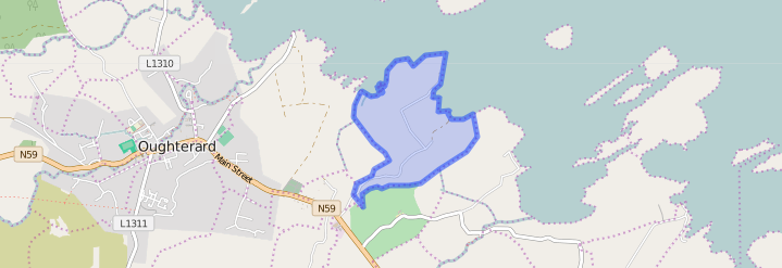
Maps
Original OS map of this area
Ireland was first mapped in the 1840s. These original maps are available online.
Original OS maps at the Ordnance Survey of Ireland website
Below is a link to the Ordnance Survey of Ireland website. It displays the original OS map that was created in the 1840s.
Information from Google Maps:
You can use this link to find this townland on Google Maps.
Information from the National Monuments Service:
You can use this link to view a map of archaeological features. This link brings you to a website wherein you will have to search for your townland.
Archaeological map from the National Monuments Service
Galway Library Website
http://places.galwaylibrary.ie/asp/fullresult.asp?id=53020
Townlands.ie
https://www.townlands.ie/galway/moycullen/kilcummin/oughterard/portacarron/


No Comments
Add a comment about this page