Porridge town East {Knockbroughaun}
Census Details

Townland and Description : Porridgetown East, Cnoc Bracháin. Hill of the pottage
Porridge town East is in the civil parish of Kilcummin. The civil Parish corresponds with the following Church of Ireland parish of Kilcummin, Galway West. In general, the civil parish and the Church of Ireland parish are the same as is the case in the Kilcummin Oughterard area.
Other Names:
Porridgetown or Knockbroughaun
Cnoc Bracháin
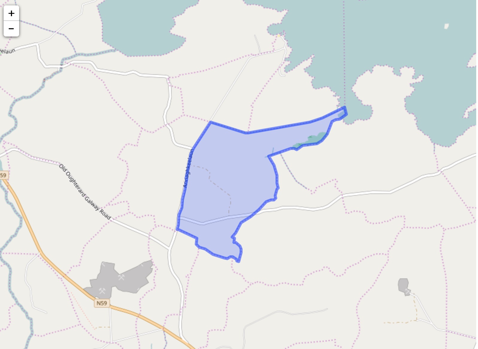
Porridgetown East Sketch Map
Porragestown County Map
Porridgetown E. High Constable for the Barony
Knockbrackan Robt. Martin, Esq., Ross
Porridgetown E. Thos. Martin, Esq., M.P.
Knockbroughane 1/3 cartron Printed Townland List
Knockbrokane Quit Rent Ledger
Poragetown County Registry 1820
Down survey 1641-1670:
The Down Survey is a mapped survey. Using the Civil Survey as a guide, teams of surveyors, mainly former soldiers, were sent out under Petty’s direction to measure every townland to be forfeited to soldiers and adventurers. The resulting maps, made at a scale of 40 perches to one inch (the modern equivalent of 1: 50,000), were the first systematic mapping of a large area on such a scale attempted anywhere. The primary purpose of these maps was to record the boundaries of each townland and to calculate their areas with great precision. The maps are also rich in other detail showing churches, roads, rivers, castles, houses and fortifications. Most towns are represented pictorially and the cartouches, the decorative titles, of each map in many cases reflect a specific characteristic of each barony. (http://downsurvey.tcd.ie)
The down survey website will tell you who owned this townland in 1641 (pre Cromwell) and in 1671 (post Cromwell).
The Tithe Applotment Books
About the Records
Tithes were a tax on agricultural produce which was payable by the occupiers of agricultural land. They were the main source of income for the parish clergy of the Church of Ireland (the largest Protestant church and the church established by law). However, in many parishes a large part of the tithes was ‘appropriate’, which meant that they were payable to a bishop, cathedral chapter or another ecclesiastical recipient, or were ‘impropriate’, which generally meant that they were payable to a local landowner. The parishes used in the Tithe Applotment Books are civil or Church of Ireland parishes, which often differ in name and territory from Catholic parishes, Acts of Parliament of 1823 and 1832 provided for the conversion of tithes into a fixed charge on land, and specified the average price of wheat or oats in the parish in the seven years before 1821 as the basis on which the tithes would be calculated. They also extended the application of tithes to pasture, where previously they had been levied only on tillage.
This change in the law resulted in the valuation of individual holdings in almost all parishes containing agricultural land, in order to assess the portion of the tithes for which each occupier of land would be liable. The apportionment was recorded for each Church of Ireland parish in a Tithe Composition Applotment Book. The information was collected and the amounts were calculated by two Parochial Commissioners, one of whom was appointed by the cess-payers of the parish and the other by the relevant Diocese of the Church of Ireland. This procedure was carried out in over 2,500 parishes between the years 1823 and 1837.
The Tithe Applotment Books are in a variety of formats, from a few pages sewn together to elaborately bound volumes. In most cases they are written in manuscript throughout, although some consist of manuscript entries on printed questionnaires. The information in the books is broadly uniform and generally includes at least the name of occupier; the size of holding, the valuation and the tithe payable. In some cases, more detailed information is provided. Some volumes have maps and most have certificates and correspondence attached.
The sub-divisions of the parish were recorded. Some of these subdivisions, such as plough lands, ceased to be in official use after the six-inch survey of the Ordnance Survey was completed in the 1840s. Only productive land was subject to tithe, and the books usually distinguish between this tithable land and untithable land such as roads or mountains. Tithable land was in some cases classified by quality, and a money value was given to each class. In some cases, the proportion of tithe payable to the rector, vicar or lay proprietor of the tithes was set out. The column for observations was sometimes completed, with information about commonage, for example.
There are a number of other points that should be noted. The acreages given in the Tithe Applotment Books are in Irish or Plantation measure, which is 1.62 times larger than statute measure. Only occupiers of land at the time of the tithe composition are recorded, so not all heads of households living in a parish at the time are included. Only rural areas are systematically covered, although inhabitants of towns who held plots of cultivable land are included. The equivalent tax in urban areas, Minister’s Money, has left few records.
The Tithe Applotment Books are an important source of information for a wide variety of researchers of pre-Famine Ireland. They provide the first surviving national list of the occupiers of land, and are used by genealogists as a partial substitute for returns of the 1821 and 1831 censuses of population, which were destroyed in 1922. They also record information on the quality of land, and provide information on pre-Ordnance Survey territorial divisions, some of which were not recognized after the 1840s.
The National Archives hold the original Tithe Applotment Books only for the twenty-six counties of the Republic of Ireland. The books for the six counties of Northern Ireland are held in the Public Record Office of Northern Ireland in Belfast. (http://titheapplotmentbooks.nationalarchives.ie/search/tab/aboutmore.jsp)
Census 1821/1831:
Population of Kilcummin Parish
1821: 8,099. 1831: 9,848
Census 1823:
Population of Kilcummin Parish
1,092 Houses. 6,219 souls
O’Donovan field names 1840
Proprietor: Chris O’ Flaherty
| Landlord | Townland | Civil Parish | Area | Land Value | Building Value | Total Value | ||||||||||||
|---|---|---|---|---|---|---|---|---|---|---|---|---|---|---|---|---|---|---|
| A. | R. | P. | £. | s. | d. | £. | s. | d. | £. | s. | d. | |||||||
| O’Flaherty, Chris | Porridgetown East | Killannin | 240 | 0 | 8 | 80 | 8 | 0 | 0 | 0 | 0 | 80 | 8 | 0 | ||||
| Total | 240 | 0 | 8 | 80 | 8 | 0 | 0 | 0 | 0 | 80 | 8 | 0 | ||||||
Barony of Moycullen. Parish of Kilcummin
N.E. of the parish. Bounded on the N. by Birchhall and Knockbaan, on the E. by Oakfield, on the south by Gurtnagivagh and Fahy, and on the W. by Porridgetown W.
Census 1841-1891:
1841: 12 houses with 63 persons
1851: 4 houses with 39 persons
1861: 2 houses with 10 persons
1871: 1 house with 12 persons
1881: ? house with ? persons
1891:1 house with 4 persons
Alphabetical Index to the Townlands and Towns of Ireland Census 1851
106 acres. 0 Roods. 20 Perches.
Griffiths Valuation 1855:
Landlord: Robert Martin
Robert Martin was a member of the Martin of Ross Family as stated in the Landed Estates Database.
- Martin (Ross) – The Martin family were established beside Ross Lake in the barony of Moycullen, county Galway, from the late 16th century, where they purchased land from the O’Flaherty’s. They were Royalist supporters and were dispossessed of their property in the city of Galway by the Cromwellians. Robert Martin received a grant of 2,909 acres in the barony of Moycullen, by patent dated 21 Aug 1677. Jasper Martin of Ross, who died in 1700, had two sons Jasper and Richard, from whom descend the two branches of the family settled at Ross and Ballynahinch. Nicholas Martin, who died in 1811, married Elizabeth O’Hara, daughter of Robert O’Hara of Lenaboy, and according to Burke’s” Landed Gentry”, a grandniece of James O’Hara, 2nd Baron Tyrawley. Their grandson, James Martin of Ross, had sixteen children from his two marriages. His daughter, Maud, married H. Callwell and they were the parents of the author, J. M. Callwell. The youngest daughter of James Martin was Violet Florence Martin of the well-known literary team Somerville and Ross. The Martins of Ross owned 5,767 acres in county Galway in the 1870s. They advertised the sale of their estate in the Landed Estates’ Court in May 1885.
- Martin (Ballynahinch) – A branch of the Anglo Norman family of Martin, one of the Tribes of Galway, was granted the O’Flaherty lands in the Connemara region in the mid-17th century. This family were a junior branch of the Martins of Ross and under the Acts of Settlement were granted vast estates in counties Galway, Mayo, Roscommon, Clare and Sligo. By a patent dated 1698 they were confirmed in the possession of their Connemara estate known as the Manor of Claremount by King William. The Westport Estate Papers document the sale of over 27,000 acres in the baronies of Moycullen and Ballynahinch by the trustees for the sale of Colonel John Browne’s estate to John Edwards for Richard Martin in 1699. The early generations of Martins lived at Birch Hall and Dangan, in the townland of Oranhill, parish of Rahoon, near Galway city. Richard Martin, better known as ‘Humanity Dick’, was the first member of the family to be reared as a Protestant. He was a famous duelist and founded the Society for the Prevention of Cruelty to Animals. Ballynahinch Castle was built in the center of his estate. His son Thomas Martin died in 1847 during the Famine and Thomas’s only daughter and heir, Mary Laetitia, inherited a heavily encumbered estate. She married her cousin, Arthur Gonne Bell, and died in New York in 1850. The Martin estates were offered for sale in two sections in 1849. Their property close to Galway town included Dangan, Corcullen, Bushypark and Killeen. Their Connemara estate was acquired by the Law Life Assurance Society in 1852, to whom it was heavily mortgaged. In 1853 the estate of almost 200,000 acres was surveyed by Thomas Colville Scott for a prospective buyer. Richard Martin, second son of Richard ‘Humanity Dick’ Martin of Ballynahinch, is recorded as holding five townlands in the parish of Killannin, barony of Moycullen, county Galway, at the time of Griffith’s Valuation although he emigrated to Canada in 1833. He was also recorded as the occupier of Clareville, a Martin home in the village of Oughterard. Many of his descendants still reside in Canada. http://www.martinhistory.net/
Census 1901:
| House Number | Surnames in House | Details |
| 1 | Moloney | View occupants or original census form (as a PDF) |
| 2 | Davoren | View occupants or original census form (as a PDF) |
| 3 | Welby | View occupants or original census form (as a PDF) |
| 4 | Moloney | View occupants or original census form (as a PDF) |
| 5 | Coyne | View occupants or original census form (as a PDF) |
| 5 | Walsh | View occupants or original census form (as a PDF) |
| 6 | Davin | View occupants or original census form (as a PDF) |
| 7 | Welby | View occupants or original census form (as a PDF) |
| 8 | Darcey | View occupants or original census form (as a PDF) |
| 8 | Sullivan | View occupants or original census form (as a PDF) |
| 9 | Walsh | View occupants or original census form (as a PDF) |
| 10 | Davin | View occupants or original census form (as a PDF) |
| 11 | Connor | View occupants or original census form (as a PDF) |
| 11 | Darcey | View occupants or original census form (as a PDF) |
| 12 | Darcey | View occupants or original census form (as a PDF) |
| 13 | Darcy | View occupants or original census form (as a PDF) |
| 14 | Darcey | View occupants or original census form (as a PDF) |
| 15 | Halloran | View occupants or original census form (as a PDF) |
| 16 | Halloran | View occupants or original census form (as a PDF) |


No Comments
Add a comment about this page