Lemonfield
Text Sandra Casey, Hyperlinks/Maps Antoinette Lydon


Lemonfield is in the civil parish of Kilcummin. The civil parish corresponds with the following Church of Ireland parish of Kilcummim, Galway West. In general the civil parish and the Church of Ireland parish are the same as is the case in the Kilcummin Oughterard area.
Irish Form of Name: Páirc Leamhán – Translation: Park of the lemons.
Lemonfield is in the Electoral Division of Oughterard, in Civil Parish of Kilcummin, in the Barony of Moycullen, in the County of Galway
Boundaries
Lemonfield is situated in the Northern extremity of the parish of Kilcummin. It is bounded on the North by Lough Corrib, on the East by Portacarron, Portacarronbeg and Rushveela, on the West by Eighterard, Fooagh East and Creg and on the South by Ardvarna, Ballymore and Glebe.
This is a list of townlands that share a border with this townland.
Some other placenames in or near this townland are…
- Annaghclooagh (bog)
- Bilberry Island (island)
- Bronteen Island (island)
- Geese Island (island)
- Illaunnacreeva (island)
- Kilcomine (field)
- Knocknacoura (trigonometrical station)
- River Island (island)
- St. Cummin’s Well (well)
- St. Cuthbert’s Well (well)
Other forms of name.
Lemonfield
Páirc Leamhán
Lemonfield in the Boundary Surveyor
Lemonfield in the Barony Cess Book
Lemonfield in the County Map
Lemonfield Domain – Local
Lemonfield, alias Parklemon, anciently Cowen or Relief – T.H. O’Flaherty Esq, Proprietor
Lemonfield in Barony Map
Limonfield – Inquis. Temp. Gul 111
Area
The area contains 371 acres of land, about 90 acres under tillage and pasture, the remainder plantation, bog rough pasture. The land is very good, free from rocks and mountains.
Lemonfield House is the residence of Captain O’Flaherty and is situated in the Eastern extremity of the townland. St Cummin’s well is in the Southern extremity, also Kilcummin old church ruins and graveyard marks its Southern boundary. The Galway to Oughterard road passes through it and there is a quarry close to its Southern boundary. The landlord was Captain O’Flaherty.
The landlord was Captain O’Flaherty. O’Flaherty is a member of the O’Flahertie (Lemonfield) family.
- The O’Flaherties of Lemonfield are descended from the O’Flaherties of Aughnenure Castle near Oughterard, county Galway. Their estate was in the parish of Kilcummin, barony of Moycullen, county Galway, and Lemonfield, close to the village of Oughterard, was their seat from the mid-18th century. There are some 17th and 19th century records relating to them in the Westport Papers. The O’Flahertie estate of over 4500 acres was advertised for sale in 1854 and a reduced acreage of 2346 acres in 1864. Both rentals included lead mines and a black marble quarry. The Irish Times reports that the 1864 sale saw many of the lots bought by a Mr. Carpenter. In the 1870s the O’Flaherties owned 2340 acres in county Galway. By March 1916 they had accepted offers from the Congested Districts’ Board for parts of their estate.
- Whitaker – The Reverend Charles Whitaker bought an estate of over 5000 acres in the parish of Kilcummin, barony of Moycullen, county Galway, from the sale of the St. George Moycullen estate in 1852-1853 and the O’Flahertie estate in 1854 (Cloghermore). He still owned the estate valued at £36 and amounting to over 4000 acres in the 1870s. His address was given as North Wales.
- Burke (Derrymaclaugha) – Richard Burke was granted 1,943 acres in the Derrymaclaughna locality, barony of Clare, county Galway, by patent dated 16 Sept 1680.
Information from the Ordnance Survey Letters:
The Ordnance Survey Letters are letters between John O’Donovan and his supervisor, Thomas Larcom, regarding the work of compiling the Field Books. These letters provide further discussion on many of the places listed in the Field Books.
References to this place can be found in the following letter.
Information from the Down Survey Website:
The Down Survey website will tell you who owned this townland in 1641 (pre Cromwell) and in 1671 (post Cromwell).
The Down Survey is a mapped survey. Using the Civil Survey as a guide, teams of surveyors, mainly former soldiers, were sent out under Petty’s direction to measure every townland to be forfeited to soldiers and adventurers. The resulting maps, made at a scale of 40 perches to one inch (the modern equivalent of 1: 50,000), were the first systematic mapping of a large area on such a scale attempted anywhere. The primary purpose of these maps was to record the boundaries of each townland and to calculate their areas with great precision. The maps are also rich in other detail showing churches, roads, rivers, castles, houses and fortifications. Most towns are represented pictorially and the cartouches, the decorative titles, of each map in many cases reflect a specific characteristic of each barony. (http://downsurvey.tcd.ie)
Townland of LEMONFIELD
Down Survey Name: Kill
1641 Owner(s): Blake, Francis (Catholic)
1670 Owner(s): Matthews, Francis (Protestant)
County: Galway
Barony: Muckullin
Parish: Killcumyn
Unprofitable land: 9 plantation acres
Profitable land: 26 plantation acres
Forfeited: 26 plantation acres
The down survey website will tell you who owned this townland in 1641 (pre Cromwell) and in 1671 (post Cromwell).
The Tithe Applotment Books
About the Records
Tithes were a tax on agricultural produce which was payable by the occupiers of agricultural land. They were the main source of income for the parish clergy of the Church of Ireland (the largest Protestant church and the church established by law). However, in many parishes a large part of the tithes was ‘appropriate’, which meant that they were payable to a bishop, cathedral chapter or another ecclesiastical recipient, or were ‘impropriate’, which generally meant that they were payable to a local landowner. The parishes used in the Tithe Applotment Books are civil or Church of Ireland parishes, which often differ in name and territory from Catholic parishes, Acts of Parliament of 1823 and 1832 provided for the conversion of tithes into a fixed charge on land, and specified the average price of wheat or oats in the parish in the seven years before 1821 as the basis on which the tithes would be calculated. They also extended the application of tithes to pasture, where previously they had been levied only on tillage.
This change in the law resulted in the valuation of individual holdings in almost all parishes containing agricultural land, in order to assess the portion of the tithes for which each occupier of land would be liable. The apportionment was recorded for each Church of Ireland parish in a Tithe Composition Applotment Book. The information was collected and two Parochial Commissioners calculated the amounts, one of who was appointed by the cess-payers of the parish and the other by the relevant Diocese of the Church of Ireland. This procedure was carried out in over 2,500 parishes between the years 1823 and 1837.
The Tithe Applotment Books are in a variety of formats, from a few pages sewn together to elaborately bound volumes. In most cases they are written in manuscript throughout, although some consist of manuscript entries on printed questionnaires. The information in the books is broadly uniform and generally includes at least the name of occupier, the size of holding, the valuation and the tithe payable. In some cases, more detailed information is provided. Some volumes have maps and most have certificates and correspondence attached.
The sub-divisions of the parish were recorded. Some of these subdivisions, such as plough lands, ceased to be in official use after the six-inch survey of the Ordnance Survey was completed in the 1840s. Only productive land was subject to tithe, and the books usually distinguish between this tithable land and untithable land such as roads or mountains. Tithable land was in some cases classified by quality, and a money value was given to each class. In some cases, the proportion of tithe payable to the rector, vicar or lay proprietor of the tithes was set out. The column for observations was sometimes completed, with information about commonage, for example.
There are a number of other points that should be noted. The acreages given in the Tithe Applotment Books are in Irish or Plantation measure, which is 1.62 times larger than statute measure. Only occupiers of land at the time of the tithe composition are recorded, so not all heads of households living in a parish at the time are included. Only rural areas are systematically covered, although inhabitants of towns who held plots of cultivable land are included. The equivalent tax in urban areas, Minister’s Money, has left few records.
The Tithe Applotment Books are an important source of information for a wide variety of researchers of pre-Famine Ireland. They provide the first surviving national list of the occupiers of land, and are used by genealogists as a partial substitute for returns of the 1821 and 1831 censuses of population, which were destroyed in 1922. They also record information on the quality of land, and provide information on pre-Ordnance Survey territorial divisions, some of which were not recognised after the 1840s.
The National Archives hold the original Tithe Applotment Books only for the twenty-six counties of the Republic of Ireland. The books for the six counties of Northern Ireland are held in the Public Record Office of Northern Ireland in Belfast. (http://titheapplotmentbooks.nationalarchives.ie/search/tab/aboutmore.jsp)
Tithe Applotment 1829
Patrick Blake, James Daley, Martin Kirwan, James Lambert, Nicholas Lynch, Richd Martin & John Wilson are listed as having land in Lemonfield in 1829.
James Daly & the Reverend John Wilson.
http://titheapplotmentbooks.nationalarchives.ie/reels/tab//004587459/004587459_00447.pdf
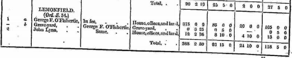
Griffith’s Valuation 1850s
In Griffith’s Valuation the area is 387 acres 17 perches with a land value of £22 14s 0d.
Occupiers of the Land
The occupiers of the land in Lemonfield at this time were:
George O’Flahertie, Graveyard and John Lynn.
Ownership of Land and Property
All of the occupiers owned a house, offices and land.
Annual Valuation
The total annual valuation of rateable property in Lemonfield came to £118 5s 0d.
Land Rates: The land rates for each of the occupiers came to £85 0s 0d for George Flahertie and £8 10s 0d for John Lynn and £0 5s 0d for the graveyard.
Building Rates: The buildings were rated at £4 10s 20d for John Lynn and £20 0s 0d for George O’Flahertie. Total rates for buildings was £24 10s 0d.
View the heads of households in the townland at this time.
http://www.askaboutireland.ie/griffith-valuation/index.xml?action=doNameSearch&PlaceID=560082
Out Offices and Land
The out office was a farm building, a cow house, piggery or barn. The land was very poor and sterile and people were always poverty-stricken. At this time most tenants were trying to eke out a living on 5acres or less and a farmer needed at least 15.3 acres to survive.
Clachan: The Irish is ‘Clochán’. A clachan was a small traditional settlement common in Ireland until the middle of the 20th century. They usually lacked a church, post office or other formal building. The origin is unknown but it is likely that they are of ancient root most likely dating to medieval times.
They were related to the rundale system of farming. According to David Lloyd, The Great Famine 1845–1849 caused such disruption to the social system that the clachans virtually disappeared.
People living in Clachans had the support of a tight knit community.
In some cases, the clachans have evolved into holiday villages or one or two houses have been taken over turning smaller houses into agricultural outhouses.
Poor Law Union Ireland
In Ireland the Poor Relief Act of 1838 divided into districts or “unions” in which the local taxable inhabitants were to be financially responsible for all paupers in the area. In 1898 the Poor Law Union was adopted as the basic administrative division in place of the civil parish and barony. Further subdivision into 828 registration districts and 3,751 district electoral divisions followed. Townlands were not arranged according to these divisions with parish and barony retained as a means to make comparisons with records gathered before 1898.
The 1838 Act
The main provisions of the 1838 Act were:
- The extension of the existing Poor Law Commissioners’ powers to Ireland, with the appointment of Assistant Commissioners who were to implement the Act in Ireland.
- The division of the country into Poor Law Unions based on Irish electoral divisions which were themselves made up from townlands.
- The creation of a Board of Guardians for each Union, two-thirds of whom were to be elected, the other third to be appointed ex officio.
- The setting up of a workhouse in each Union.
- The collection of a local poor-rate to finance the system.
- Assistance for emigration.
Initially, 130 Unions were created, based upon 2,049 electoral divisions. The divisions were composed of townlands, a peculiarly Irish unit, traditionally of 120 Irish acres in area. (Between 1848 and 1850, an additional 33 Unions were created by subdividing and reorganizing the boundaries of some existing Unions, particularly in the west of the country.
Boards of Guardians were elected annually on 25th March. Only rate-payers were eligible for election, which effectively disenfranchised most of the native Irish who were usually tenants at this time. Rate-payers were allowed between one and six votes depending on the size of a valuation of their property.
Townlands
A town land is one of the smallest land divisions in Ireland. They range in size from a few acres to thousands of acres. Many are Gaelic in origin, but some came into existence after the Norman invasion 1169. Lemonfield is a townland.
Population & Census Information
People who lived here:
You can retrieve a list of people who lived in this townland from 1827 to 1911. This list is compiled from the following resources.
- The Tithe Applotment Books
- Griffith’s Valuation
- 1901 Census
- 1911 Census
List of nineteenth century and early twentieth century inhabitants of this townland.
Census 1841-1891
1841 – 1 house with 7 people
1851 – 1 house with 7 people
1861 – 3 houses with 21 people
1871 – 2 houses with 15 people
1881 – 3 houses (3 inhabited) with 16 people (6 males/10 females). There were 25 outbuildings. Total Valuation of Houses & Lands £118 0s 0d.
1891 – 3 houses (3 inhabited) with 13 people (7 males/6 females). There were 25 outbuildings. Total Valuation of Houses & Lands £117 0s 0d.
1901 Census Lemonfield
This is a return of the members of the family, their Visitors, Boarders, Servants who slept or abode in their house on the night of Sunday March 31st 1901 in Lemonfield.
There were 4 houses listed in the Townland of Lemonfield. Three were occupied and one of them was uninhabited. The people were a mix of Roman Catholic and Church of Ireland. There were 20 in total of farm buildings and out offices.
Class of House: The class of house depended on the materials used in the roof, walls, number of rooms and number of front windows. A 1st class house was considered the highest standard.
Walls of the houses: The walls were of stone, brick, concrete or of mud, wood or other perishable material.
Roofs: Roofs were of slate, iron, tiles, thatch, wood or other perishable material. The roofs of houses were of thatch, wood or perishable material. Most likely they were thatched as there was ample reeds for thatching in the lakes.
House Occupancy: Each of the 3 houses was occupied by one family.
The people listed as Head of the Family were also listed as the lawful Landholder of the property.
Enumerators Extract
http://www.census.nationalarchives.ie/reels/nai000840802/
House & Building Return
http://www.census.nationalarchives.ie/reels/nai000840803/
Out Office & Farm Steading
http://www.census.nationalarchives.ie/reels/nai000840804/
House 1: John Purvis O’Fflahertie aged 51 was listed as head of the family. He was a landlord and lived with his two sisters, Barbara Jane 49 and Annie Maud aged 42. They were all single. They were born in Surrey, England and hence they were Church of Ireland. They could all read and write and spoke only English. Also in the house at the time was Sarah Gavin. Sarah was listed as a domestic servant. She was aged 22 and was Roman Catholic, born in Galway. Sarah could read and write and spoke Irish and English. They lived in a 1st class house, 18 rooms occupying 4 persons with 14 front windows. They had a number of out offices and farm buildings; 1 stable, 1 coach house, 5 cow houses, 1 calf house, 1 fowl house, 1 boiling house, 1 barn, 1 potato house, 1 workshop, 1 shed and 1 store.
http://www.census.nationalarchives.ie/pages/1901/Galway/Oughterard/Lemonfield/1394693
House 2: Elizabeth Gallagher aged 50 was head of the house. She was married, born in England. She was listed as a farmer and retired dressmaker. Elizabeth spoke English and was able to read and write. She was Church of Ireland. Elizabeth lived in a 2nd class house with 4 windows, 6 rooms occupying one person. She had one stable, a coach house and a cow house.
http://www.census.nationalarchives.ie/pages/1901/Galway/Oughterard/Lemonfield/1394694/
House 3: Bridget Fahy aged 70 was head of the family. She was a widow and lived with her son Peter 34 and servant Ned Halloran aged 36. She was listed as a farmer and could not read or write. They all spoke English and Irish. Her son Peter was listed as a farmer’s son and Ned as a labourer. They lived in a 3rd class house with 2 front windows and 2 rooms occupying 3 persons.
http://www.census.nationalarchives.ie/pages/1901/Galway/Oughterard/Lemonfield/1394695/
1911 Census Lemonfield
This is a return of the Members of families in Lemonfield, their visitors, boarders and servants who slept or abode in the house on the night of Sunday the 2nd of April 1911.
Description of the Houses
All the houses in Lemonfield were listed as private dwellings and were built of concrete or stone. The roofs of the houses were of slate or tile with the exception of one of the houses which had a roof of wood, thatch or other perishable material. Most likely it was thatched. The heads of the families were listed as the landholders. One family lived in each property. The Class of the house depended on the material used in the roof, walls, number of rooms and number of front windows.
General Information
One family lived in each of the 3 houses listed. They were a mix of Roman Catholics and Church of Ireland and the head of the family was the landholder. There were 6 males and 5 females a total of 11 persons living in the village.
Enumerators Extract
http://www.census.nationalarchives.ie/reels/nai002435666/
House & Building Return
http://www.census.nationalarchives.ie/reels/nai002435668/
Out Office & Farm Steadings
http://www.census.nationalarchives.ie/reels/nai002435670/
House 1: John Purvis O’Fflahertie, aged 61 was head of the family. He was a single man, listed as Justice of the Peace and a farmer. John was born in England. In the house at the time was his servant, Mary Moloney, aged 19. He lived in a 1st class house with 9 windows to the front and 10 rooms occupying just himself. He had a stable, one coach house, one harness room, one cow house, one piggery, one fowl house, one barn, one turf shed and one shed.
http://www.census.nationalarchives.ie/pages/1911/Galway/Oughterard/Lemonfield/471275/
House 2: John R. Scoones, aged 54 was head of the family. He was married to Elizabeth aged 51. In the house on the night of the census was his daughter Mabel Kay aged 27 and his granddaughter Irene Kay aged just 4 months. They could all read and write and spoke English. John was a Baptist Minister. He lived in a 2nd class house with 5 windows to the front. The house had 8 rooms occupying 4 persons. He had 1 stable, 1 cow house, a piggery and a shed. John & Elizabeth were married for 28 years; they had 5 children. Mabel Kay was married for 2 years, she had 1 child. John, Elizabeth & Mabel were born in England.
http://www.census.nationalarchives.ie/pages/1911/Galway/Oughterard/Lemonfield/471276/
House 3: Peter Fahy, a farmer aged 45 was head of the family. He lived with his wife Honor aged 35. They had 3 sons Bartly aged 5, John aged 4 and Peter aged 2. Peter and Honor spoke English and Irish and could both read and write. Peter & Honor were married for 6 years; they had 3 children. They lived in a 3rd class house with 2 windows and 2 rooms occupying 5 people. They had 1 cow house.
http://www.census.nationalarchives.ie/pages/1911/Galway/Oughterard/Lemonfield/47127/
Church records of births, deaths and marriages:
Church records of births, deaths and marriages are available online at http://www.rootsireland.ie. To search these records, you will need to know the ‘church parish’ rather than the ‘civil parish’. (The civil parish is the pre-reformation parish and was frequently used as a unit of administration in the past.)
Lemonfield is in the civil parish of Kilcummin.
Roman Catholic parishes:
This civil parish corresponds with the following Roman Catholic parish or parishes.
- Carraroe
- Kilannin
- Kilcummin/Oughterard
- Rosmuc
Church of Ireland parishes:
This civil parish corresponds with the following Church of Ireland parish.
- Kilcummin
In general, the civil parish and the Church of Ireland parish are the same, but this is not always the case.
Maps
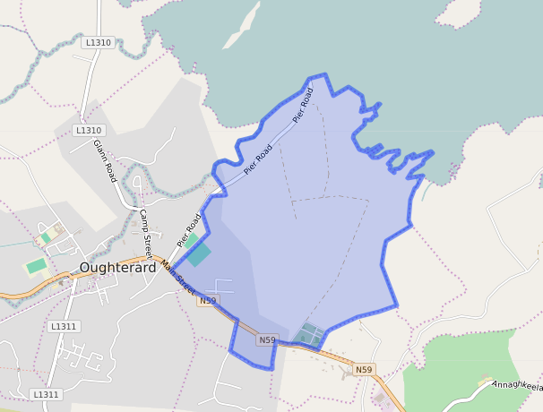
It is located at 53° 25′ 49″ N, 9° 18′ 17″ W.
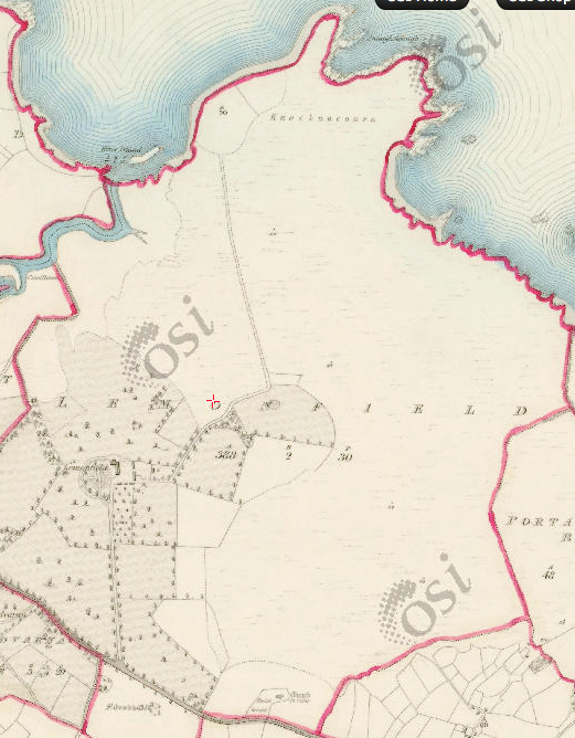
Original OS map of this area.
Ireland was first mapped in the 1840s. These original maps are available online.
Original OS maps at the Ordnance Survey of Ireland website.
Below is a link to the Ordnance Survey of Ireland website. It displays the original OS map that was created in the 1840s.
Information from Google Maps
You can use this link to find this townland on Google Maps.
Information from the National Monuments Service
You can use this link to view a map of archaeological features.
This link brings you to a website wherein you will have to search for your townland.
Archaeological map from the National Monuments Service
Townlands.ie Website
https://www.townlands.ie/galway/moycullen/kilcummin/oughterard/lemonfield/
Galway Library Website
http://places.galwaylibrary.ie/place/52863


No Comments
Add a comment about this page