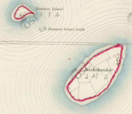
Inishshanboe
Antoinette Lydon


")


Inishshanboe is in the civil parish of Kilcummin. The civil Parish corresponds with the following Church of Ireland parish of Kilcummin, Galway West. In general, the civil parish and the Church of Ireland parish are the same as is the case in the Kilcummin Oughterard area.
Irish Form of Name: Inis Sean Bhó
Translation: island of the old cow
Civil Parish: Kilcummin View all place names in this civil parish.
Inishshanboe is in the Electoral Division of Oughterard, in Civil Parish of Kilcummin, in the Barony of Moycullen, in the County of Galway
Other Forms of the Name with authority source (if provided) in italics:
Inishshanboe
Inis Sean Bhó
Innishanwa Barony Map
Innishshanvo Boundary Surveyor
Innishanwa County Map
Walsh Island Local
Innishanvo alias Walsh’s Island
Description:
Inishshanboe Contains 16¾ acres all under tillage and pasture. It is also inhabited. Situated S.W. of Urkaunbeg and S.E. of the Bronteen Islands.
Other placesnames in this townland:
Some other placenames in or near this townland are…
- Bronteen Island S. (rock)
Situation:
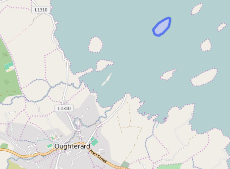
In Lough Corrib. It belongs to the townland of Lemonfield.
Landlord
Proprietor; Captain O’Flaherty of Lemonfield
Information on the owner’s family from the Landed Estates Database;
O’Flaherty is a member of the O’Flahertie (Lemonfield) family.
The Tithe Applotment Books
About the Records
Tithes were a tax on agricultural produce which was payable by the occupiers of agricultural land. They were the main source of income for the parish clergy of the Church of Ireland (the largest Protestant church and the church established by law). However, in many parishes a large part of the tithes was ‘appropriate’, which meant that they were payable to a bishop, cathedral chapter or other ecclesiastical recipient, or were ‘impropriate’, which generally meant that they were payable to a local landowner. The parishes used in the Tithe Applotment Books are civil or Church of Ireland parishes, which often differ in name and territory from Catholic parishes, Acts of Parliament of 1823 and 1832 provided for the conversion of tithes into a fixed charge on land, and specified the average price of wheat or oats in the parish in the seven years before 1821 as the basis on which the tithes would be calculated. They also extended the application of tithes to pasture, where previously they had been levied only on tillage.
This change in the law resulted in the valuation of individual holdings in almost all parishes containing agricultural land, in order to assess the portion of the tithes for which each occupier of land would be liable. The apportionment was recorded for each Church of Ireland parish in a Tithe Composition Applotment Book. The information was collected and the amounts were calculated by two Parochial Commissioners, one of whom was appointed by the cess-payers of the parish and the other by the relevant Diocese of the Church of Ireland. This procedure was carried out in over 2,500 parishes between the years 1823 and 1837.
The Tithe Applotment Books are in a variety of formats, from a few pages sewn together to elaborately bound volumes. In most cases they are written in manuscript throughout, although some consist of manuscript entries on printed questionnaires. The information in the books is broadly uniform and generally includes at least the name of occupier; the size of holding, the valuation and the tithe payable. In some cases, more detailed information is provided. Some volumes have maps and most have certificates and correspondence attached.
The sub-divisions of the parish were recorded. Some of these subdivisions, such as plough lands, ceased to be in official use after the six-inch survey of the Ordnance Survey was completed in the 1840s. Only productive land was subject to tithe, and the books usually distinguish between this tithable land and untithable land such as roads or mountains. Tithable land was in some cases classified by quality, and a money value was given to each class. In some cases, the proportion of tithe payable to the rector, vicar or lay proprietor of the tithes was set out. The column for observations was sometimes completed, with information about commonage, for example.
There are a number of other points that should be noted. The acreages given in the Tithe Applotment Books are in Irish or Plantation measure, which is 1.62 times larger than statute measure. Only occupiers of land at the time of the tithe composition are recorded, so not all heads of households living in a parish at the time are included. Only rural areas are systematically covered, although inhabitants of towns who held plots of cultivable land are included. The equivalent tax in urban areas, Minister’s Money, has left few records.
The Tithe Applotment Books are an important source of information for a wide variety of researchers of pre-Famine Ireland. They provide the first surviving national list of the occupiers of land, and are used by genealogists as a partial substitute for returns of the 1821 and 1831 censuses of population, which were destroyed in 1922. They also record information on the quality of land, and provide information on pre-Ordnance Survey territorial divisions, some of which were not recognized after the 1840s.
The National Archives hold the original Tithe Applotment Books only for the twenty-six counties of the Republic of Ireland. The books for the six counties of Northern Ireland are held in the Public Record Office of Northern Ireland in Belfast. (http://titheapplotmentbooks.nationalarchives.ie/search/tab/aboutmore.jsp)
No information available.
Information from the Down Survey Website.
The Down Survey is a mapped survey. Using the Civil Survey as a guide, teams of surveyors, mainly former soldiers, were sent out under Petty’s direction to measure every townland to be forfeited to soldiers and adventurers. The resulting maps, made at a scale of 40 perches to one inch (the modern equivalent of 1: 50,000), were the first systematic mapping of a large area on such a scale attempted anywhere. The primary purpose of these maps was to record the boundaries of each townland and to calculate their areas with great precision. The maps are also rich in other detail showing churches, roads, rivers, castles, houses and fortifications. Most towns are represented pictorially and the cartouches, the decorative titles, of each map in many cases reflect a specific characteristic of each barony. (http://downsurvey.tcd.ie)
The down survey website will tell you who owned this townland in 1641 (pre Cromwell) and in 1671 (post Cromwell).
No information available.
Griffith Valuation 1855
In Griffith’s valuation the area was 16 acres, 1 rood & 1 perch of land, there was no rateable value list for Inishshanboe on its own.
Occupier of Land – Rev. John Darcy
Immediate Lessors – George F. O’Flahertie.
http://www.askaboutireland.ie/griffith-valuation/index.xml?action=doNameSearch&PlaceID=560232
View the heads of households in the townland at this time.
Poor Law Union Ireland
In Ireland the Poor Relief Act of 1838 divided into districts or “unions” in which the local taxable inhabitants were to be financially responsible for all paupers in the area. In 1898 the Poor Law Union was adopted as the basic administrative division in place of the civil parish and barony. Further subdivision into 828 registration districts and 3,751 district electoral divisions followed. Townlands were not arranged according to these divisions with parish and barony retained as a means to make comparisons with records gathered before 1898.
The 1838 Act
The main provisions of the 1838 Act were:
- The extension of the existing Poor Law Commissioners’ powers to Ireland, with the appointment of Assistant Commissioners who were to implement the Act in Ireland.
- The division of the country into Poor Law Unions based on Irish electoral divisions which were made up from townlands.
- The creation of a Board of Guardians for each Union, two-thirds of whom were to be elected, the other third to be appointed ex officio.
- The setting up of a workhouse in each Union.
- The collection of a local poor-rate to finance the system.
- Assistance for emigration.
Initially, 130 Unions were created, based upon 2,049 electoral divisions. The divisions were composed of townlands, a peculiarly Irish unit, traditionally of 120 Irish acres in area. (Between 1848 and 1850, subdividing and reorganizing the boundaries of some existing Unions, particularly in the west of the country created an additional 33 Unions.
Boards of Guardians were elected annually on 25th March. Only ratepayers were eligible for election, which effectively disenfranchised most of the native Irish who were usually tenants at this time. Ratepayers were allowed between one and six votes depending on the size of a valuation of their property.
What is a townland?
A townland is one of the smallest land divisions in Ireland. They range in size from a few acres to thousands of acres. Many are Gaelic in origin, but some came into existence after the Norman invasion of 1169. Inishshanboe is a townland.
Population & Census Information
People who lived here:
You can retrieve a list of people who lived in this townland from 1827 to 1911. This list is compiled from the following resources.
- The Tithe Applotment Books
- Griffith’s Valuation
- 1901 Census
- 1911 Census
List of nineteenth century and early twentieth century inhabitants of this townland.
1841-1891 Census
1841 – 2 houses with 14 people
1851 – 1 house with 10 people
1861 – 1 house with 5 people
1871 – 2 houses with 4 people
1881 – 1 house (1 inhabited) with 9 people (6 males, 3 females). There were 2 outbuildings.
The valuation of Houses & Land in 1881 was £11 0s 0d.
1891 – 2 houses (1 inhabited) with 3 people (2 males, 1 female). There were 3 outbuildings.
The valuation of Houses & Land in 1891 was £11 0s 0d.
1901 Census
This is a return of the members of the family, visitors, boarders or servants who slept or abode in their house on the night of Sunday March 31st 1901 in Inishshanboe.
There were 2 houses listed in the Townland of Inishshanboe. There were 5 Roman Catholics & 1 Church of Irish; they were born in Co. Galway & Sussex. 6 people lived in Inishshanboe (4 males and 2 females) in the townland. There were 12 farm buildings and out offices which included cow house, potato house, 3 fowl houses, turf house, workshop, shed, store, boat house & paint house.
Enumerators Extract
http://www.census.nationalarchives.ie/reels/nai000841023/
House & Building Return
http://www.census.nationalarchives.ie/reels/nai000841024/
Out Office & Farm Steadings
http://www.census.nationalarchives.ie/reels/nai000841025/
House 1
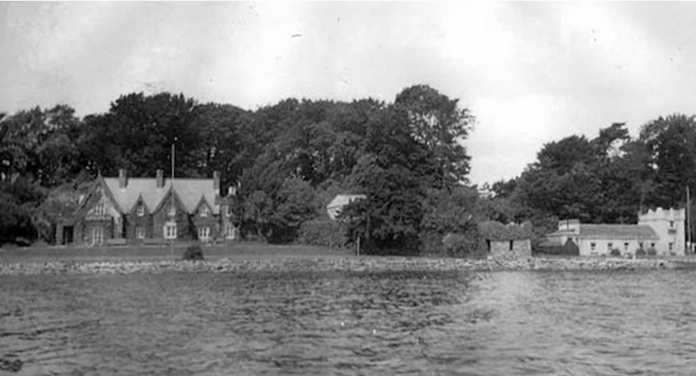
Edward William Aucketell Jones aged 36 was head of the family; he was married.
Edward was a Gentleman, Retired Captain of H.M. Army & J.P. for County Galway. Edward could read & write. He was born in Sussex. He was Church of Ireland.
He lived in a 1st class house with 6 rooms and 8 front windows. He had a cow house, potato house, 3 fowl houses, turf house, workshop, store, boat house & paint house. This was a private dwelling.
http://www.census.nationalarchives.ie/pages/1901/Galway/Oughterard/Inishanboe/1394790/
Note: His surname is Anketell-Jones
House 2
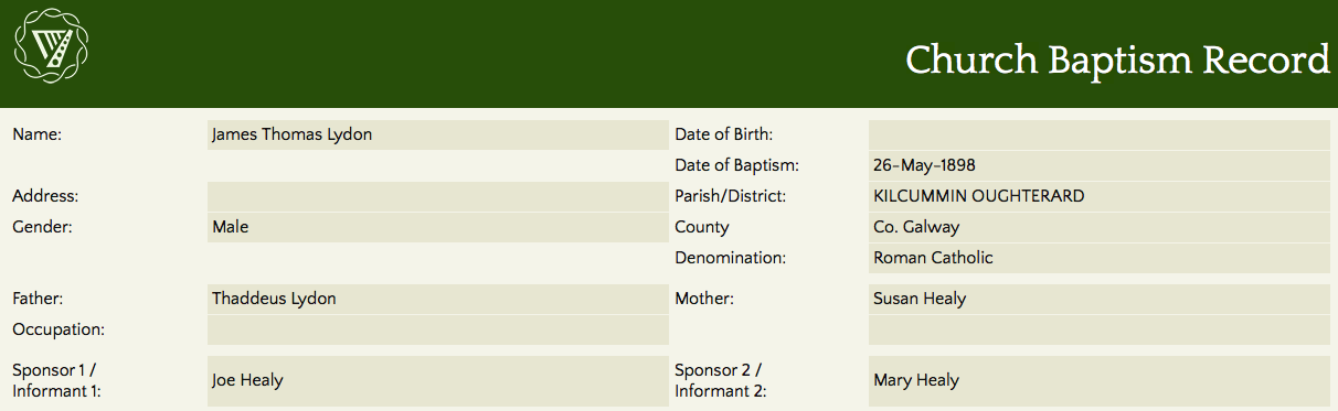
Thady Lydon aged 39 was head of the family; married to Susan aged 32. They lived with their children Patrick aged 15, Joseph aged 8 & Mary Anne aged 9 months.
Thady was a sailor; he could not read. Susan was a housekeeper; she could read and write and spoke Irish & English. Patrick was a farm labourer; he could read & write. Joseph & Mary Anne could not read.
They lived in a 2nd class house with 3 rooms and 6 front windows. They had a shed. This was a private dwelling.
http://www.census.nationalarchives.ie/pages/1901/Galway/Oughterard/Inishanboe/1394791/
1911 Census
This is a return of the Members of the families in Inishshanboe, their visitors, boarders and servants who slept or abode in the house on the night of Sunday 2nd April 1911.
There were 2 houses (2 uninhabited) listed in the Townland of Inishshanboe. Of the people living in Inishshanboe all 8 (3 males/5 females) 5 were Roman Catholics & 3 Church of Ireland.
People that lived in Inishshanboe were born in Galway, England, Cavan, Wicklow. There were a total of 11 farm buildings and out offices which included cow houses, calf house, fowl house, turf house, workshop, sheds, store, kennel a boat house.
Enumerators Extract
http://www.census.nationalarchives.ie/reels/nai002436047/
House & Building Return
http://www.census.nationalarchives.ie/reels/nai002436049/
Out Offices & Farm Steadings
http://www.census.nationalarchives.ie/reels/nai002436051/
House 1
Edward William Anketell-Jones aged 46 was head of the family; married. He lived with widow Ruth Metaxa aged 32, a visitor; niece Thelma Louisa Evelyne H Metaxa aged 7 & Elizabeth Kelly aged 34; single.
Edward was a retired captain in the Army & J.P. (Justice of the Peace) for Co Galway; born in England. Ruth was a countess; born in Cavan & Thelma was a countess & scholar; born in England. They were Church of Ireland. Elizabeth was a cook; born in Wicklow. She was Roman Catholic. The entire household could read & write.
Ruth was married for 10 years; she had 2 children with both living at the time of the census.
They lived in a 1st class house with 6 rooms and 9 front windows. They had 2 cow houses, calf house, fowl house, turf house, workshop, 2 sheds, store, kennel a boat house. This was a private dwelling.
http://www.census.nationalarchives.ie/pages/1911/Galway/Oughterard/Inishshamboe/471372/
House 2
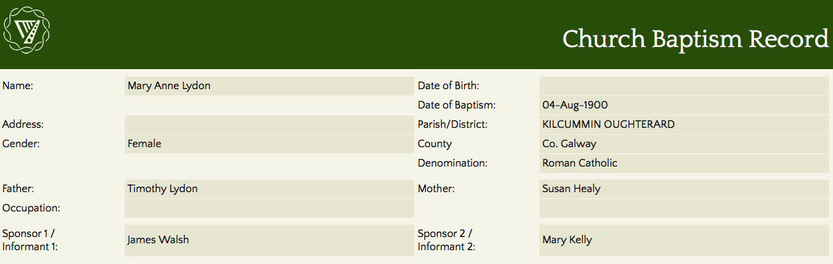
Thomas Lydon aged 55 was head of the family; a widower. He lived with his son Joseph aged 18, daughter Mary Anne aged 11 & widowed mother-in-law Mary Healy aged 70.
Thomas was a caretaker; Joseph was a labourer. The entire family could not read. Thomas & Mary spoke Irish & English. They were Roman Catholic.
They lived in a 2nd class house with 2 rooms and 3 front windows. This was a private dwelling.
http://www.census.nationalarchives.ie/pages/1911/Galway/Oughterard/Inishshamboe/471373/
Church records of births, deaths and marriages:
Church records of births, deaths and marriages are available online at http://www.rootsireland.ie/ To search these records, you will need to know the ‘church parish’ rather than the ‘civil parish’. (The civil parish is the pre-reformation parish and was frequently used as a unit of administration in the past.)
Inishshanboe is in the civil parish of Kilcummin.
Roman Catholic parishes:
This civil parish corresponds with the following Roman Catholic parish or parishes.
- Carraroe
- Kilannin
- Kilcummin/Oughterard
- Rosmuc
Church of Ireland parishes:
This civil parish corresponds with the following Church of Ireland parish.
- Kilcummin
In general, the civil parish and the Church of Ireland parish are the same, but, this is not always the case.
Maps
It is located at 53° 27′ 9″ N, 9° 17′ 28″ W.
Original OS map of this area.
Ireland was first mapped in the 1840s. These original maps are available online.
Original OS maps at the Ordnance Survey of Ireland website.
Below is a link to the Ordnance Survey of Ireland website. It displays the original OS map that was created in the 1840s.
Information from Google Maps.
You can use this link to find this townland on Google Maps.
Information from the National Monuments Service.
You can use this link to view a map of archaeological features. This link brings you to a website wherein you will have to search for your townland.
Archaeological map from the National Monuments Service
Galway Library Website
http://places.galwaylibrary.ie/place/53226
Townlands.ie Website
https://www.townlands.ie/galway/moycullen/kilcummin/oughterard/inishshanboe/
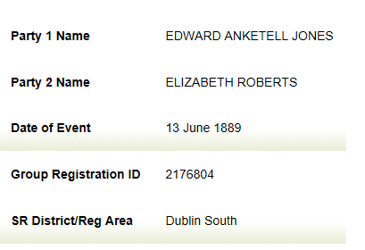
Following on having received an email from a relative of Edward Anketell- Jones, I did researched and found that Edward married Elizabeth Roberts in 1889 (see attached record). Edward passed away in March 1933 and by strange coincidence Timothy (Thady) Lydon who worked on Inishshanboe for many years passed away just 2 days before Edward.
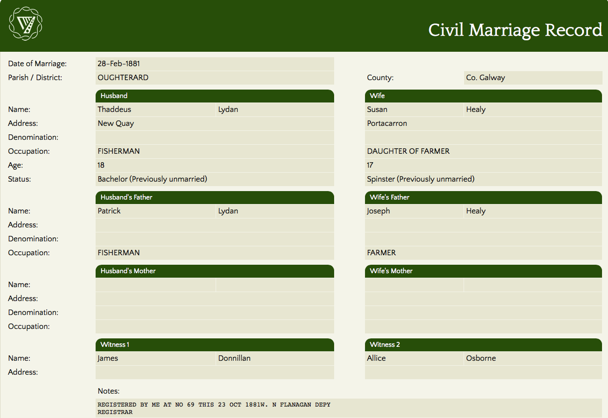
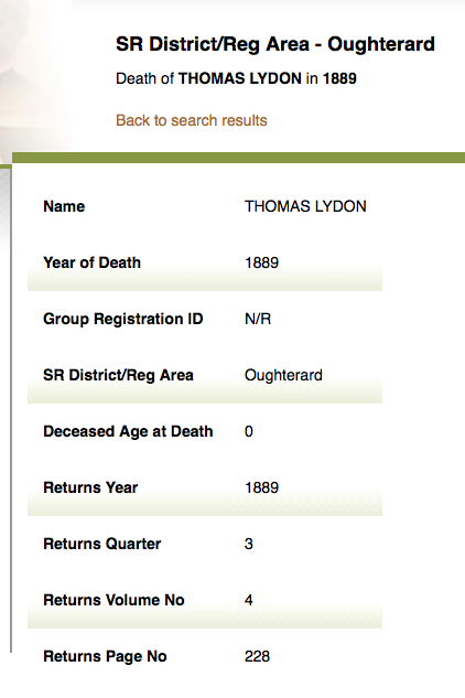
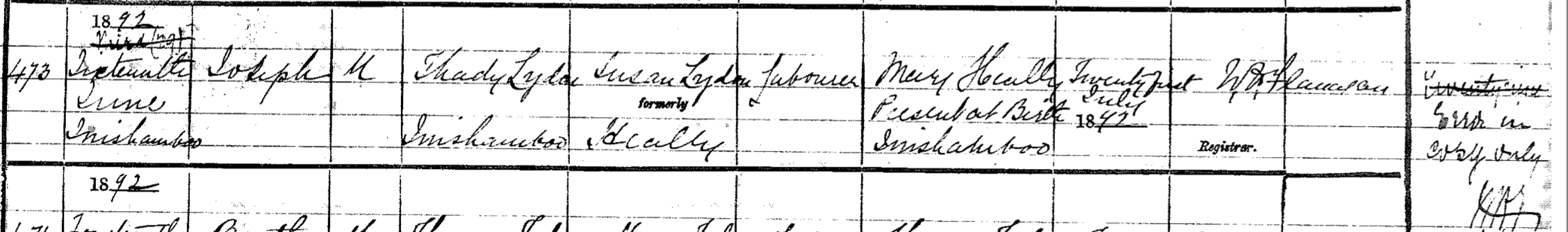
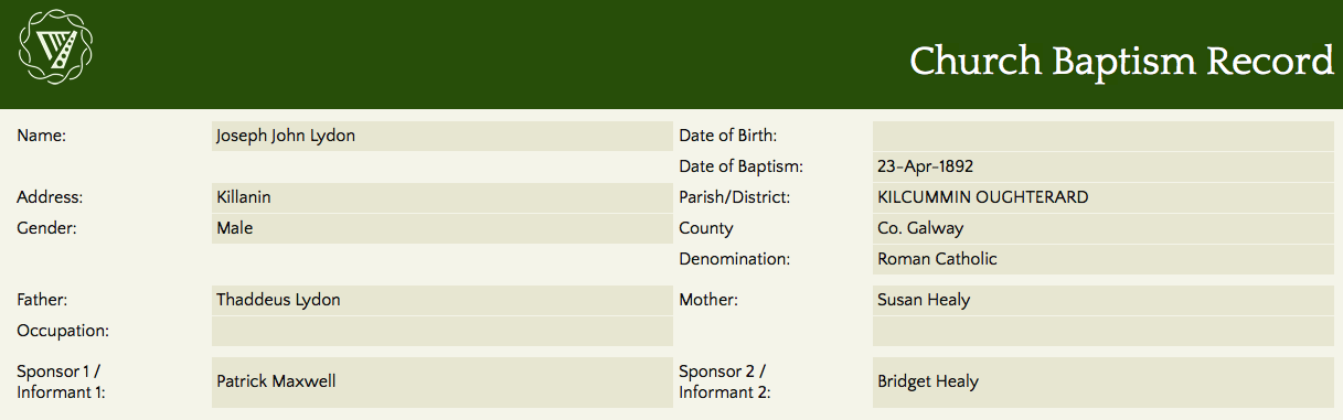
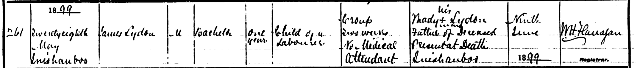
They Lydon Family are listed on both the 1901 & !911 Census. Timothy & Susan (Healy) married in Feb 1881. They had 5 children (records found for 5). Patrick born 1885, Thomas born 1889 and sadly passed away that year, Joseph born 1892, James born 1898, passed away in 1899 & Mary Anne born in 1900. Susan passed away in 1905.


Comments about this page
Hi There,
I am interested in your family member Ruth Mataxa.
I believe she sold Gort-n-Gavin and built a house on the same land to the north which we call ‘Corin Cottage’ and have lived in for 14 years. I would love to have a photo of Ruth to hang in the cottage and to know a little more about her as they call her the Countess around these parts.I wonder would this be possible.
Miriam O’Reilly ‘Corin Cottage’ Glann Road, Oughterard
I believe these Lydons are part of my family although I haven’t done extensive research. I was brought up in Enland, being told that my Lydon family worked and lived on a small island on Loch Corrib as laborours/ helpers for a fine house. I had no other details. Looking at this research, I think my Great grandfather, who came to Liverpool in the 1800s could have been Thady’s brother/ cousin? My grandfather, John Lydon was then born in Liverpool in 1888. I hope to come to the area in 2020 to make sense of it.
Hi.
As an Anketell-Jones family member I can tell you that Ruth Metaxa was the younger sister of Edward W Anketell-Jones of Inishanboe. She was the widow of Count Metaxa to whom she was married for 3 years and by whom she had a son and a daughter. She was born in Cavan in 1877/8. She returned to Ireland and lived in Oughterard at Gort-n-Gavin.
Add a comment about this page