Gortdrishagh
Text - Mary Kyne, Hyperlinks & Maps - Antoinette Lydon


Gortdrisagh is in the civil parish of Kilcummin. The civil Parish corresponds with the following Church of Ireland parish of Kilcummin, Galway West. In general the civil parish and the Church of Ireland parish are the same as is the case in the Kilcummin Oughterard area.
The Irish form of the name is Gort Driseach – briary field
Gortdrisagh is in the Electoral Division of Oughterard, in Civil Parish of Kilcummin, in the Barony of Moycullen, in the County of Galway
Other forms of name.
Gortdrishagh
Gort Driseach
Gort driseach
Gurtdrishogh Boundary Surveyor
Gortdrisagh Barony Cess Book
Gurtadrishugh County Map
Gortdrisshogh Local
Briarfield Rector of Kilcummin
Description:
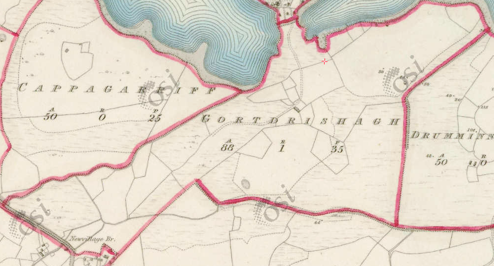
Land good, contains 88½ acres about 70 acres under tillage and pasture, the remainder bog and rough pasture, a neat house situate in the N. extremity of this townland and also a gravel pit close to its southern boundary.
Situation:
Situated in the northern extremity of the parish. Bounded on the N. by Annagh Wood, and Lough Corrib, E. by Drimmanakill, W. by Cappagarriv and New Village and S. by Derramweel townlands.
Martin (Ross) – The Martin family were established beside Ross Lake in the barony of Moycullen, county Galway, from the late 16th century, where they purchased land from the O’Flahertys. They were Royalist supporters and were dispossessed of their property in the city of Galway by the Cromwellians. Robert Martin received a grant of 2,909 acres in the barony of Moycullen, by patent dated 21 Aug 1677. Jasper Martin of Ross, who died in 1700, had two sons Jasper and Richard, from whom descend the two branches of the family settled at Ross and Ballynahinch. Nicholas Martin, who died in 1811, married Elizabeth O’Hara, daughter of Robert O’Hara of Lenaboy, and according to Burke’s ”Landed Gentry”, a grandniece of James O’Hara, 2nd Baron Tyrawley. Their grandson, James Martin of Ross, had sixteen children from his two marriages. His daughter, Maud, married H. Callwell and they were the parents of the author, J. M. Callwell. The youngest daughter of James Martin was Violet Florence Martin of the well known literary team Somerville and Ross. The Martins of Ross owned 5,767 acres in county Galway in the 1870s. They advertised the sale of their estate in the Landed Estates’ Court in May 1885.
- Martin (Ballynahinch) – A branch of the Anglo Norman family of Martin, one of the Tribes of Galway, was granted the O’Flaherty lands in the Connemara region in the mid 17th century. This family were a junior branch of the Martins of Ross and under the Acts of Settlement were granted vast estates in counties Galway, Mayo, Roscommon, Clare and Sligo. By a patent dated 1698 they were confirmed in the possession of their Connemara estate known as the Manor of Claremount by King William. The Westport Estate Papers document the sale of over 27,000 acres in the baronies of Moycullen and Ballynahinch by the trustees for the sale of Colonel John Browne’s estate to John Edwards for Richard Martin in 1699. The early generations of Martins lived at Birch Hall and Dangan, in the townland of Oranhill, parish of Rahoon, near Galway city. Richard Martin, better known as ‘Humanity Dick’, was the first member of the family to be reared as a Protestant. He was a famous duellist and founded the Society for the Prevention of Cruelty to Animals. Ballynahinch Castle was built in the centre of his estate. His son Thomas Martin died in 1847 during the Famine and Thomas’s only daughter and heir, Mary Laetita, inherited a heavily encumbered estate. She married her cousin, Arthur Gonne Bell, and died in New York in 1850. The Martin estates were offered for sale in two sections in 1849. Their property close to Galway town included Dangan, Corcullen, Bushypark and Killeen. Their Connemara estate was acquired by the Law Life Assurance Society in 1852, to whom it was heavily mortgaged. In 1853 the estate of almost 200,000 acres was surveyed by Thomas Colville Scott for a prospective buyer. Richard Martin, second son of Richard ‘Humanity Dick’ Martin of Ballynahinch, is recorded as holding five townlands in the parish of Killannin, barony of Moycullen, county Galway, at the time of Griffith’s Valuation although he emigrated to Canada in 1833. He was also recorded as the occupier of Clareville, a Martin home in the village of Oughterard. Many of his descendants still reside in Canada. http://www.martinhistory.net/
Tithe Applotment Books 1829:
About the Records
Tithes were a tax on agricultural produce which was payable by the occupiers of agricultural land. They were the main source of income for the parish clergy of the Church of Ireland (the largest Protestant church and the church established by law). However, in many parishes a large part of the tithes were ‘appropriate’, which meant that they were payable to a bishop, cathedral chapter or other ecclesiastical recipient, or were ‘impropriate’, which generally meant that they were payable to a local landowner. The parishes used in the Tithe Applotment Books are civil or Church of Ireland parishes, which often differ in name and territory from Catholic parishes, Acts of Parliament of 1823 and 1832 provided for the conversion of tithes into a fixed charge on land, and specified the average price of wheat or oats in the parish in the seven years before 1821 as the basis on which the tithes would be calculated. They also extended the application of tithes to pasture, where previously they had been levied only on tillage.
This change in the law resulted in the valuation of individual holdings in almost all parishes containing agricultural land, in order to assess the portion of the tithes for which each occupier of land would be liable. The apportionment was recorded for each Church of Ireland parish in a Tithe Composition Applotment Book. The information was collected and the amounts were calculated by two Parochial Commissioners, one of whom was appointed by the cess-payers of the parish and the other by the relevant Diocese of the Church of Ireland. This procedure was carried out in over 2,500 parishes between the years 1823 and 1837.
The Tithe Applotment Books are in a variety of formats, from a few pages sewn together to elaborately bound volumes. In most cases they are written in manuscript throughout, although some consist of manuscript entries on printed questionnaires. The information in the books is broadly uniform and generally includes at least the name of occupier; the size of holding, the valuation and the tithe payable. In some cases more detailed information is provided. Some volumes have maps and most have certificates and correspondence attached.
The sub-divisions of the parish were recorded. Some of these subdivisions, such as ploughlands, ceased to be in official use after the six inch survey of the Ordnance Survey was completed in the 1840s. Only productive land was subject to tithe, and the books usually distinguish between this tithable land and untithable land such as roads or mountains. Tithable land was in some cases classified by quality, and a money value was given to each class. In some cases the proportion of tithe payable to the rector, vicar or lay proprietor of the tithes was set out. The column for observations was sometimes completed, with information about commonage, for example.
There are a number of other points that should be noted. The acreages given in the Tithe Applotment Books are in Irish or Plantation measure, which is 1.62 times larger than statute measure. Only occupiers of land at the time of the tithe composition are recorded, so not all heads of households living in a parish at the time are included. Only rural areas are systematically covered, although inhabitants of towns who held plots of cultivable land are included. The equivalent tax in urban areas, Minister’s Money, has left few records.
The Tithe Applotment Books are an important source of information for a wide variety of researchers of pre-Famine Ireland. They provide the first surviving national list of the occupiers of land, and are used by genealogists as a partial substitute for returns of the 1821 and 1831 censuses of population, which were destroyed in 1922. They also record information on the quality of land, and provide information on pre-Ordnance Survey territorial divisions, some of which were not recognised after the 1840s.
The National Archives hold the original Tithe Applotment Books only for the twenty-six counties of the Republic of Ireland. The books for the six counties of Northern Ireland are held in the Public Record Office of Northern Ireland in Belfast. (http://titheapplotmentbooks.nationalarchives.ie/search/tab/aboutmore.jsp)
James Scully, Briarfield, Gortdrisagh was listed.
Information from the Down Survey Website.
The Down Survey is a mapped survey. Using the Civil Survey as a guide, teams of surveyors, mainly former soldiers, were sent out under Petty’s direction to measure every townland to be forfeited to soldiers and adventurers. The resulting maps, made at a scale of 40 perches to one inch (the modern equivalent of 1: 50,000), were the first systematic mapping of a large area on such a scale attempted anywhere. The primary purpose of these maps was to record the boundaries of each townland and to calculate their areas with great precision. The maps are also rich in other detail showing churches, roads, rivers, castles, houses and fortifications. Most towns are represented pictorially and the cartouches, the decorative titles, of each map in many cases reflect a specific characteristic of each barony. (http://downsurvey.tcd.ie)
Townland of GORTDRISHAGH (Moycullen By)
Down Survey Name: Gortnecassagh
1641 Owner(s): O’Flahertye, Murragh McBrien (Catholic)
1670 Owner(s): Martin, Richard (Catholic)
County: Galway
Barony: Muckullin
Parish: Killcumyn
Profitable land: 7 plantation acres
Forfeited: 7 plantation acres
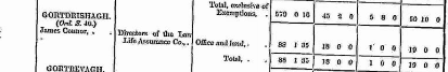
Griffiths Valuation 1850’s
In Griffith’s Valuation the area is 88 acres 1rood 35 perch with a land value of £18 0s 0d. Value of Buildings is £1, and the total value is £19.
Occupiers of the Land: James Connor.
Landlord was: Directors of the Law Life Assurance Co.
Ownership of Land and Property
James Connor owned a house, out office and land with a total valuation of £19.
View the heads of households in the townland at this time.
http://www.askaboutireland.ie/griffith-valuation/index.xml?action=doNameSearch&PlaceID=560054
Out Offices and Land
The out office was a farm building, a cow house, piggery or barn. The land was very poor and sterile and people were always poverty-stricken. At this time most tenants were trying to eke out a living on 5acres or less and a farmers needed at least 15.3 acres to survive.
Poor Law Union Ireland
In Ireland the Poor Relief Act of 1838 divided into districts or “unions” in which the local taxable inhabitants were to be financially responsible for all paupers in the area. In 1898 the Poor Law Union was adopted as the basic administrative division in place of the civil parish and barony. Further subdivision into 828 registration districts and 3,751 district electoral divisions followed. Townlands were not arranged according to these divisions with parish and barony retained as a means to make comparisons with records gathered before 1898.
The 1838 Act
The main provisions of the 1838 Act were:
- The extension of the existing Poor Law Commissioners’ powers to Ireland, with the appointment of Assistant Commissioners who were to implement the Act in Ireland.
- The division of the country into Poor Law Unions based on Irish electoral divisions which were themselves made up from townlands.
- The creation of a Board of Guardians for each Union, two-thirds of whom were to be elected, the other third to be appointed ex officio.
- The setting up of a workhouse in each Union.
- The collection of a local poor-rate to finance the system.
- Assistance for emigration.
Initially, 130 Unions were created, based upon 2,049 electoral divisions. The divisions were composed of townlands, a peculiarly Irish unit, traditionally of 120 Irish acres in area. (Between 1848 and 1850, an additional 33 Unions were created by subdividing and reorganizing the boundaries of some existing Unions, particularly in the west of the country.
Boards of Guardians were elected annually on 25th March. Only rate-payers were eligible for election, which effectively disenfranchised most of the native Irish who were usually tenants at this time. Rate-payers were allowed between one and six votes depending on the size of a valuation of their property.
Townlands
A town land is one of the smallest land divisions in Ireland. They range in size from a few acres to thousands of acres. Many are Gaelic in origin, but some came into existence after the Norman invasion 1169. Gortdrisagh is a townland.
Population & Census Information
- The Tithe Applotment Books
- Griffith’s Valuation
- 1901 Census
- 1911 Census
1841-1891 Census
1841 – No one living in the town land
1851 – 1 house with 16 people
1861 – 1 house it does not state how many people living in the town land
1871 – No one living in the town land
1881 – 1 house (1 inhabited) with 6 people (4 males, 2 females). There were no outbuildings.
The valuation of Houses & Land in 1881 was £19 0s 0d.
1891 – 1 house (1 inhabited) with 5 people (3 males, 2 females). There were 2 outbuildings.
The valuation of Houses & Land in 1891 was £19 0s 0d.
1901 Census Gortdrisagh
This is a return of the members of the family, visitors, boarders or servants who slept or abode in their house on the night of Sunday March 31st 1901 in Gortdrisagh.
There were 2 houses listed in the Townland of Gortdrisagh. There were 2 males and 3 females living in Gortdrisagh. The people were Roman Catholics and Church of Ireland There were 9 in total of farm buildings and out offices which included a stable, cow houses, a piggery, turf house. coach house, horse house and workshop.
Class of House: The class of house depended on the materials used in the roof, walls, number of rooms and number of front windows. A 1st class house was considered the highest standard. Gortdrisagh’s main house was a class 1 house
Walls of the houses: The walls were of stone, brick, concrete or of mud, wood or other perishable material. The houses in Gortdrisagh were built of stone, brick or concrete. There were no mud cabins.
Landholder of the property unless otherwise stated was the lawful owner.
Roofs were of slate, iron, tiles, thatch, wood or other perishable material. The roofs of houses were of thatch, wood or perishable material. Most likely the class 2 house was thatched as there was ample reeds for thatching in the lakes. Gortdrisagh House was slated.
House Occupancy: Each of the 2 houses was occupied by one family.
The people listed as Head of the Family were also listed as the lawful Landholder of the property except in the case of Gortdrisagh who at caretakers at this time.
Enumerators Extract
http://www.census.nationalarchives.ie/reels/nai000840775/
House & Building Return
http://www.census.nationalarchives.ie/reels/nai000840776/
Out Office & Farm Steadings
http://www.census.nationalarchives.ie/reels/nai000840777/
House 1: Susan Hegarty who was married aged 55 was head of the family. She was born in Dublin and belonged to the Church of Ireland. Her daughter Louise who was born in Westmeath, aged 18 and single lived with her. They were both caretakers of the property for Captain Spencer Anketel Jones. They could read and write and they spoke English. They lived in a Class 1 house with 15 front windows. 2 persons occupied 6 rooms. Attached to the house was a stable, coach house, horse house, cow house, turf house and workshop.
http://www.census.nationalarchives.ie/pages/1901/Galway/Oughterard/Gartdrishagh/1394677/
House 2: Honor Faherty aged 60 was head of the family. She was a housekeeper. John her son aged 40 and Peter 22 both single were herd’s men. The family spoke Irish and English and Peter could read and write while Honor and John did not. They were Roman Catholics. They lived in a class 3 house with 2 front windows. 3 persons occupied 2 rooms. They had 2 cow houses and a piggery.
http://www.census.nationalarchives.ie/pages/1901/Galway/Oughterard/Gartdrishagh/1394678/
Gortdrisagh Census 1911
This is a return of the Members of families in Gortdrisagh, their visitors, boarders and servants who slept or abode in the house on the night of Sunday the 2nd of April 1911.
Description of the Houses
The 2 houses in Gortdrisagh were listed as private dwellings and were built of concrete or stone. The roofs of the houses were of wood, thatch or other perishable material. Most likely they were thatched. The head of the family were listed as the landholders. One family lived in each property. The Class of the house depended on the material used in the roof, walls, number of rooms and number of front windows. Most of the houses came under “2’ in the census form meaning that there could be 2, 3, or 4, rooms in the house.
Enumerators Extract
http://www.census.nationalarchives.ie/reels/nai002435610/
House & Building Return
http://www.census.nationalarchives.ie/reels/nai002435612/
Out Office & Farm Steadings
http://www.census.nationalarchives.ie/reels/nai002435614/
House 1: Joseph Mc Namara aged 48 a Surgeon Physician by profession was head of the family. He was a Roman Catholic and was born in Co. Clare. He lived with his wife Edith aged 60 who was born in London and belonged to the Church of Ireland. They were married 4 years and they had no children. Living with them was Kate Knox a general servant who was born in Co. Wexford. They could read and write and they spoke English. They lived in a Class 1 house with 34 front windows. 3 persons occupied 18 rooms. They had a stable, coach house, horse house, fowl house, barn, turf house, boat house, store and workshop. There were three other buildings listed.
http://www.census.nationalarchives.ie/pages/1911/Galway/Oughterard/Gortdrishagh/471261/
House 2; Michael Noone, born in County Mayo, aged 33, a general servant was head of the family. He lived with his wife Mary aged 25 born in Co. Galway and their son Patrick Michael 6months old. They spoke Irish and English and they could read and write. They were married one year and had one child. They were Roman Catholics. They lived in a class 2 house with 3 front windows. 3 persons occupied 2 rooms. They had a piggery. The landholder was Dr. J Mc Namara.
http://www.census.nationalarchives.ie/pages/1911/Galway/Oughterard/Gortdrishagh/471262/
Church records of births, deaths and marriages:
Roman Catholic parishes:
- Carraroe
- Kilannin
- Kilcummin/Oughterard
- Rosmuc
Church of Ireland parishes:
- Kilcummin
Maps
It is located at 53° 27′ 30″ N, 9° 20′ 28″ W.
Original OS map of this area.
Original OS maps at the Ordnance Survey of Ireland website.
Information from Google Maps.
Information from the National Monuments Service.
Galway Library Website
Townlands.ie Website
Additional information from ‘A Valley Remembers Glann”
GORTDRISAGH
Gort an Drisagh Briary Field
Area 90 acres
This small townland on the shores of the lake lies west of Druminakill. It is almost surrounded by water but for a narrow piece of land that joins it to the mainland. It is mostly wooded with natural forest. In the 1850s the land here was owned by
Thomas B. Martin of Ballinahinch. The Martins, at the time of “Humanity Dick” once had the biggest estate in all of British Isles at 200,000 acres. The Martins replaced the O Flaherty Clan as masters of Connemara. Humanity Dick’s son Thomas was known as king of Connemara. The land at Gortdrisagh was at that time described as having 70 acres of tillage and pasture with the remainder bog and rough pasture. A neat house situated in the north extremity of this townland and also a gravel pit close to its southern boundary. The lessor of the land was the Law Life Assurance Co. A James Connor was the occupier, with an office and land. The Griffth valuation was £19.0s.0d.
At the time of the 1911 census two families lived in the townland of Gortdrisagh: Joseph and Edith McNamara and their servant Kate Knox, and Michael Noone and his wife Mary along with their son Patrick Michael. The Noone family moved to Oughterard.
Gortdrisagh house was built here in the 1890s by Spencer Anketel Jones (Family of Jones Island.) He is said to have had one of the first motorised cars in Ireland, a category B type car, these may have been 3 wheelers. Its registration number was IM 10. Cars were first registered in 1903.
Robert C. Hodgson also had a car IM 126 in 1908. Spencer Anketel Jones was killed sking in the Alps. Shortly after his death is said that an old “Trolly” type car, without a driver, followed an Oughterard man that was in Glann courting one night, all the way from Gortdrisagh gate to the town and as far as the Pier Road. To the relief of the poor young lad the car headed down towards the Lake and Jones’s Island. The man was petrified, weak at the knees and in a sweat. When he cycled fast the car went fast, when he slowed up it slowed up, when he stopped it stopped. It took him a few days to recover such was the fright he received. The man’s name was Paddy Walsh from Billamore and the woman he was courting was Annie Canavan a sister of Mick. They went to America, got married and both lived long lives. Paddy died in 2010. And that is a true story.
After Spencer A. Jones died Gortdrisagh was bought by Dr. Joseph McNamara from Dublin, he expanded it. It was then bought by a Mr Davy and Kennedy. They removed the extention previously added. Then Major O Sullivan, a brother of the actress Maureen O Sullivan bought it. In the early seventies Dr. Kevin Glynn of Glynns of Galway bought it. He and his wife Mary Rose Joyce and family lived there until the early ‘90s. The present owner is a Mr Brian O Donnell.
There are two relatively new houses in Gortdrisagh – Bridie Molloy and Peter Kelly (Stephen John).


No Comments
Add a comment about this page