Freaghillaun-beg
Antoinette Lydon


Freaghillaunbeg is in the civil parish of Kilcummin. The civil Parish corresponds with the following Church of Ireland parish of Kilcummin, Galway West. In general, the civil parish and the Church of Ireland parish are the same as is the case in the Kilcummin Oughterard area.
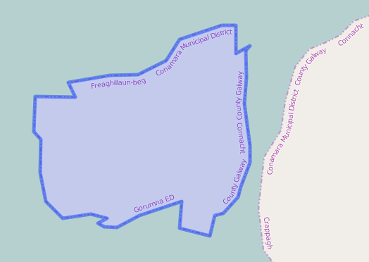
Freaghillaun-beg is in the Electoral Division of Gorumna, in Civil Parish of Kilcummin, in the Barony of Moycullen, in the County of Galway
Irish Form of Name: Fraoch Oileán Beag
Translation: little heathy island
Parish: Kilcummin
View all place names in this civil parish.
Other Forms of the Name with the authority source (if provided) in italics.
Freaghillaunbeg
Fraoch Oileán Beag
Fraoch oileán
Freighillaunbeg Boundary Surveyor
Freigh Island Barony Cess Book
Freeghillaunbeg or small Heath Island Local
Feaghillaun Barony Map
Feaghillaun County Map
Description:
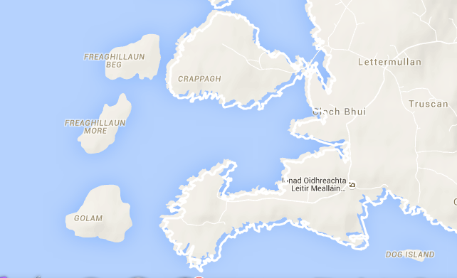
Freaghillaunbeg contains 263 acres of rough pasture; situate W. of Freeghillaunmore and Clynagh Islands.
Situation:
In the sea, it belongs to the townland of Rossmuck.
Information from the Down Survey Website:
The Down Survey website will tell you who owned this townland in 1641 (pre Cromwell) and in 1671 (post Cromwell).
No information available.
Griffiths Valuation 1850’s
No information available.
Information
What is a townland?
A townland is one of the smallest land divisions in Ireland. They range in size from a few acres to thousands of acres. Many are Gaelic in origin, but some came into existence after the Norman invasion of 1169.
Freaghillaunbeg is a townland.
Information and Census Information
People who lived here:
Nobody lived on this island from the 1841-1911 Census.
You can retrieve a list of people who lived in this townland from 1827 to 1911. This list is compiled from the following resources.
- The Tithe Applotment Books
- Griffith’s Valuation
- 1901 Census
- 1911 Census
List of nineteenth century and early twentieth century inhabitants. (Griffith’s Valuation has a link to this townland, however it is for Freaghillaunmore, a neighbouring island)
Church records of births, deaths and marriages:
Church records of births, deaths and marriages are available online at http://www.rootsireland.ie. To search these records you will need to know the ‘church parish’ rather than the ‘civil parish’. (The civil parish is the pre-reformation parish and was frequently used as a unit of administration in the past.)
Freaghillaunbeg is in the civil parish of Kilcummin.
Catholic parish:
This civil parish corresponds with the following Roman Catholic parish or parishes.
- Clonbern & Kilkerrin in Galway East.
- Carraroe in Galway West.
- Kilannin in Galway West.
- Kilcummin/Oughterard in Galway West.
- Rosmuc in Galway West.
Church of Ireland parish:
This civil parish corresponds with the following Church of Ireland parish.
- Kilcummin in Galway West.
In general, the civil parish and the Church of Ireland parish are the same, but this is not always the case.
Maps
It is located at 53° 14′ 31″ N, 9° 45′ 46″ W.
Original OS map of this area
Ireland was first mapped in the 1840s. These original maps are available online.
Original OS maps at the Ordnance Survey of Ireland website
Below is a link to the Ordnance Survey of Ireland website. It displays the original OS map that was created in the 1840s.
Information from Google Maps:
You can use this link to find this townland on Google Maps.
Information from the National Monuments Service:
You can use this link to view a map of archaeological features. This link brings you to a website wherein you will have to search for your townland.
Archaeological map from the National Monuments Service
Townlands.ie Website
http://www.townlands.ie/galway/moycullen/kilcummin/gorumna/freaghillaun-beg/
Galway Library Website
http://places.galwaylibrary.ie/asp/fullresult.asp?id=52679


No Comments
Add a comment about this page