Derreenmeel (Derrymoyle)
Antoinette Lydon


Derreenmeel (Derrymoyle) is in the civil parish of Kilcummin. The civil Parish corresponds with the following Church of Ireland parish of Kilcummin, Galway West. In general, the civil parish and the Church of Ireland parish are the same as is the case in the Kilcummin Oughterard area.
Irish Form of Name: Doirín Mil
Translation: little derry or oak wood of the beast or monster
Civil Parish: Kilcummin View all place names in this civil parish.
Derreenmeel is in the Electoral Division of Oughterard, in Civil Parish of Kilcummin, in the Barony of Moycullen, in the County of Galway
Other Forms of the Name with authority source (if provided) in italics:
Derreenmeel
Doirín Mil
Derramweel Boundary Surveyor
Derrymeel County Map
Derreenmeel Local
Derymile Rector of Kilcummin
Comment:
Not moyle or mweel
Derreenmeel contains 426¾ acres about 100 acres under tillage and pasture, the remainder bog and mountain pasture. A bye road the centre of which forms the western boundary of this townland
Situated in the northern extremity of the parish.
This is a list of townlands that share a border with this townland.
Some other placenames in or near this townland are…
- Knockmanus (hill)
- Slievenavinnoge (tract of mountain bog)
Landlord/Proprietor:
Thomas B. Martin of Ballynahinch Castle. Thomas B. Martin is a member of the Martin (Ross) family.
Landed Estates Database:
- Martin (Ross) – The Martin family were established beside Ross Lake in the barony of Moycullen, county Galway, from the late 16th century, where they purchased land from the O’Flahertys. They were Royalist supporters and were dispossessed of their property in the city of Galway by the Cromwellians. Robert Martin received a grant of 2,909 acres in the barony of Moycullen, by patent dated 21 Aug 1677. Jasper Martin of Ross, who died in 1700, had two sons Jasper and Richard, from whom descend the two branches of the family settled at Ross and Ballynahinch. Nicholas Martin, who died in 1811, married Elizabeth O’Hara, daughter of Robert O’Hara of Lenaboy, and according to Burke’s ”Landed Gentry”, a grandniece of James O’Hara, 2nd Baron Tyrawley. Their grandson, James Martin of Ross, had sixteen children from his two marriages. His daughter, Maud, married H. Callwell and they were the parents of the author, J. M. Callwell. The youngest daughter of James Martin was Violet Florence Martin of the well known literary team Somerville and Ross. The Martins of Ross owned 5,767 acres in county Galway in the 1870s. They advertised the sale of their estate in the Landed Estates’ Court in May 1885.
- Martin (Ballynahinch) – A branch of the Anglo Norman family of Martin, one of the Tribes of Galway, was granted the O’Flaherty lands in the Connemara region in the mid 17th century. This family were a junior branch of the Martins of Ross and under the Acts of Settlement were granted vast estates in counties Galway, Mayo, Roscommon, Clare and Sligo. By a patent dated 1698 they were confirmed in the possession of their Connemara estate known as the Manor of Claremount by King William. The Westport Estate Papers document the sale of over 27,000 acres in the baronies of Moycullen and Ballynahinch by the trustees for the sale of Colonel John Browne’s estate to John Edwards for Richard Martin in 1699. The early generations of Martins lived at Birch Hall and Dangan, in the townland of Oranhill, parish of Rahoon, near Galway city. Richard Martin, better known as ‘Humanity Dick’, was the first member of the family to be reared as a Protestant. He was a famous duellist and founded the Society for the Prevention of Cruelty to Animals. Ballynahinch Castle was built in the centre of his estate. His son Thomas Martin died in 1847 during the Famine and Thomas’s only daughter and heir, Mary Laetita, inherited a heavily encumbered estate. She married her cousin, Arthur Gonne Bell, and died in New York in 1850. The Martin estates were offered for sale in two sections in 1849. Their property close to Galway town included Dangan, Corcullen, Bushypark and Killeen. Their Connemara estate was acquired by the Law Life Assurance Society in 1852, to whom it was heavily mortgaged. In 1853 the estate of almost 200,000 acres was surveyed by Thomas Colville Scott for a prospective buyer. Richard Martin, second son of Richard ‘Humanity Dick’ Martin of Ballynahinch, is recorded as holding five townlands in the parish of Killannin, barony of Moycullen, county Galway, at the time of Griffith’s Valuation although he emigrated to Canada in 1833. He was also recorded as the occupier of Clareville, a Martin home in the village of Oughterard. Many of his descendants still reside in Canada. http://www.martinhistory.net/
Information from the Down Survey Website:
The Down Survey website will tell you who owned this townland in 1641 (pre Cromwell) and in 1671 (post Cromwell).
The Down Survey is a mapped survey. Using the Civil Survey as a guide, teams of surveyors, mainly former soldiers, were sent out under Petty’s direction to measure every townland to be forfeited to soldiers and adventurers. The resulting maps, made at a scale of 40 perches to one inch (the modern equivalent of 1:50,000), were the first systematic mapping of a large area on such a scale attempted anywhere. The primary purpose of these maps was to record the boundaries of each townland and to calculate their areas with great precision. The maps are also rich in other detail showing churches, roads, rivers, castles, houses and fortifications. Most towns are represented pictorially and the cartouches, the decorative titles, of each map in many cases reflect a specific characteristic of each barony. (http://downsurvey.tcd.ie)
Townland of DERREENMEEL
Down Survey Name: Dirrymeele
1641 Owner(s): Martin, Robert (Catholic)
1670 Owner(s): Martin, Richard (Catholic); Kelly, Donnogh (Catholic)
County: Galway
Barony: Muckullin
Parish: Killcumyn
Profitable land: 5 plantation acres
Forfeited: 5 plantation acres
The down survey website will tell you who owned this townland in 1641 (pre Cromwell) and in 1671 (post Cromwell).
http://downsurvey.tcd.ie/landowners.php#mc=53.45039,-9.33719&z=14
The Tithe Applotment Books
About the Records
Tithes were a tax on agricultural produce which was payable by the occupiers of agricultural land. They were the main source of income for the parish clergy of the Church of Ireland (the largest Protestant church and the church established by law). However, in many parishes a large part of the tithes was ‘appropriate’, which meant that they were payable to a bishop, cathedral chapter or other ecclesiastical recipient, or were ‘impropriate’, which generally meant that they were payable to a local landowner. The parishes used in the Tithe Applotment Books are civil or Church of Ireland parishes, which often differ in name and territory from Catholic parishes, Acts of Parliament of 1823 and 1832 provided for the conversion of tithes into a fixed charge on land, and specified the average price of wheat or oats in the parish in the seven years before 1821 as the basis on which the tithes would be calculated. They also extended the application of tithes to pasture, where previously they had been levied only on tillage.
This change in the law resulted in the valuation of individual holdings in almost all parishes containing agricultural land, in order to assess the portion of the tithes for which each occupier of land would be liable. The apportionment was recorded for each Church of Ireland parish in a Tithe Composition Applotment Book. The information was collected and the amounts were calculated by two Parochial Commissioners, one of whom was appointed by the cess-payers of the parish and the other by the relevant Diocese of the Church of Ireland. This procedure was carried out in over 2,500 parishes between the years 1823 and 1837.
The Tithe Applotment Books are in a variety of formats, from a few pages sewn together to elaborately bound volumes. In most cases they are written in manuscript throughout, although some consist of manuscript entries on printed questionnaires. The information in the books is broadly uniform and generally includes at least the name of occupier; the size of holding, the valuation and the tithe payable. In some cases, more detailed information is provided. Some volumes have maps and most have certificates and correspondence attached.
The sub-divisions of the parish were recorded. Some of these subdivisions, such as plough lands, ceased to be in official use after the six-inch survey of the Ordnance Survey was completed in the 1840s. Only productive land was subject to tithe, and the books usually distinguish between this tithable land and untithable land such as roads or mountains. Tithable land was in some cases classified by quality, and a money value was given to each class. In some cases, the proportion of tithe payable to the rector, vicar or lay proprietor of the tithes was set out. The column for observations was sometimes completed, with information about commonage, for example.
There are a number of other points that should be noted. The acreages given in the Tithe Applotment Books are in Irish or Plantation measure, which is 1.62 times larger than statute measure. Only occupiers of land at the time of the tithe composition are recorded, so not all heads of households living in a parish at the time are included. Only rural areas are systematically covered, although inhabitants of towns who held plots of cultivable land are included. The equivalent tax in urban areas, Minister’s Money, has left few records.
The Tithe Applotment Books are an important source of information for a wide variety of researchers of pre-Famine Ireland. They provide the first surviving national list of the occupiers of land, and are used by genealogists as a partial substitute for returns of the 1821 and 1831 censuses of population, which were destroyed in 1922. They also record information on the quality of land, and provide information on pre-Ordnance Survey territorial divisions, some of which were not recognized after the 1840s.
The National Archives hold the original Tithe Applotment Books only for the twenty-six counties of the Republic of Ireland. The books for the six counties of Northern Ireland are held in the Public Record Office of Northern Ireland in Belfast. (http://titheapplotmentbooks.nationalarchives.ie/search/tab/aboutmore.jsp)
Tithe Applotment – 1829
Peter Lee, James McDonagh, Peter McDonagh, Matthew McDonagh, Patt McGauley, Morgan Mealey & John Malloy had 200 acres of land; 20 acres of 2nd quality land with a fee of 1s per acre, 30 acres of 3rd quality with a fee of 3d per acre & 150acres of 5th quality land with a fee of ⅛d per acre.
The Tithes were payable to Richard Martin Esq. Reverend James Daly & Reverend John Wilson.
http://titheapplotmentbooks.nationalarchives.ie/reels/tab//004587459/004587459_00435.pdf
http://places.webworld.org/people/8572
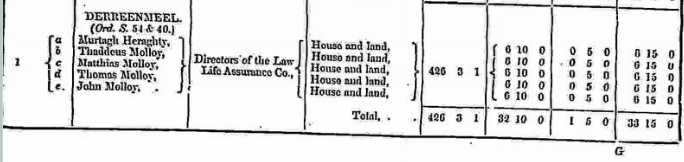
Griffith Valuation 1855
In Griffith’s Valuation the area in Derreenmeel was a total of 426 acres, 3 rood & 1 perch of land, houses & offices with a value of £32-10s-0d (Land) & £1-5s-0d (Buildings). Each tenant paid £6 10s 0d rent for the land & £0 5s 0d for the buildings.
Occupier: Murtagh Heraghty Thaddeus Molloy, Matthias Molloy, Thomas Molloy & John Molloy.
Immediate Lessor: Directors of the Law Life Assurance Co.
View the heads of households in the townland at this time.
http://www.askaboutireland.ie/griffith-valuation/index.xml?action=doNameSearch&PlaceID=559874
What is a townland?
A townland is one of the smallest land divisions in Ireland. They range in size from a few acres to thousands of acres. Many are Gaelic in origin, but some came into existence after the Norman invasion of 1169.
Derreenmeel is a townland.
Population & Census Information
People who lived here:
You can retrieve a list of people who lived in this townland from 1827 to 1911. This list is compiled from the following resources.
- The Tithe Applotment Books
- Griffith’s Valuation
- 1901 Census
- 1911 Census
List of nineteenth century and early twentieth century inhabitants of this townland.
Census 1841-1891
1841 – 14 houses with 74 people
1851 – 10 houses with 49 people
1861 – 13 houses with 61 people
1871 – 11 houses with 67 people
1881 – 10 houses with 59 people (31 males/28 females). There were 17 outbuildings. Total Valuation of Houses & Lands £35 15s 0d.
1891 – 12 houses with 79 people (43 males/36 females). There was 26 Outbuildings. Total Valuation of Houses & Lands £35 0s 0d.
1841/1851 Old Age Pension Census Search Forms
An application was made by Hynes from Derrenmeel in the Parish of Kilcummin in the Barony of Moycullen. The surname Heraghty also appears on the application. Reference # Cen/S/2000. Record was found for 1851.
An application was made by Ellen Hynes. Address: Mrs. Bridget Connor (John) Tonewell, Oughterard Co. Galway
Full Names of Father and Mother of the applicant: John & Nappy Hynes (Heraghty)
Residence in 1851: Townland: Derreenmeel, Parish: Kilcummin, Barony: Moycullen, County: Galway
Derrymoyle not a tnld (townland) name
Date of receipt: 8.9.17 Reference: CenS/11/2000 Application No. C/17 46952
Return searched by ??? 13.9.17 Sheet 10 Certified by J F 14/9/17
Copy dispatched FO 17.9.17 2/- written on top right corner of application
Census 1901
This is a return of the member of the family, their Visitors, Boarders, and Servants who slept or abode in their house on the night of 31st of March 1901 in Derreenmeel. There were 10 buildings listed in the townland of Derreenmeel. 53 (24 females/ 29 males) were all Roman Catholics. The people that lived in Derreenmeel were born in Co. Galway. The townland had 29 outbuildings, which included cow houses, calf houses, piggeries, barns & fowl houses.
Enumerators Extract
http://www.census.nationalarchives.ie/reels/nai000840698/
House & Building Return
http://www.census.nationalarchives.ie/reels/nai000840699/
Return of Out Offices & Farm Steadings
http://www.census.nationalarchives.ie/reels/nai000840700/
House 1
Stephen Tierney aged 40 was head of the family; married to Ellen aged 41. They lived with their children Mary aged 15, Matt aged 13, Peter aged 11, Margaret aged 8, Joseph aged 6, Maria aged 3 & Bridget aged 4 months.
Stephen was a farmer; Mary was a farmer’s daughter; Matt, Peter, Margaret & Joseph were scholars. Stephen & Joseph could not read. Ellen, Mary & Matt could read and write. Peter & Margaret could read. They spoke Irish & English. Maria & Bridget could not read.
They lived in a 3rd class house with 2 rooms and 2 front windows. They had a cow house & a piggery. This was a private dwelling.
http://www.census.nationalarchives.ie/pages/1901/Galway/Oughterard/Derreenmeel/1394632/
House 2
Michael Feerrick aged 44 was head of the family; married to Margaret aged 47. They lived with their children David aged 23, Murty aged 20, Bridget aged 14, Patrick aged 11, John aged 8, & Martin aged 8.
Michael was a farmer; David & Murty were farmer’s sons; Bridget was a farmer’s daughter; Patrick, John & Martin were scholars. Michael, Murty, Bridget & Patrick could read & write. Margaret & David could not read. John & Martin could read. The entire family spoke Irish & English.
They lived in a 2nd class house with 2 rooms and 3 front windows. They had a cow house, calf house & piggery. This was a private dwelling.
http://www.census.nationalarchives.ie/pages/1901/Galway/Oughterard/Derreenmeel/1394633/
House 3
Thomas Heraghty aged 70 was head of the family; married to Margaret aged 68. They lived with their daughter Maria aged 20.
Thomas was a farmer. Maria was a farmer’s daughter. Thomas & Margaret could not read; Maria could read & write. The family spoke Irish & English.
They lived in a 3rd class house with 2 rooms and 1 front window. They had a cow house. This was a private dwelling.
http://www.census.nationalarchives.ie/pages/1901/Galway/Oughterard/Derreenmeel/1394634/
House 4
Timothy Molloy aged 62 was head of the family; married to Bridget aged 60. They lived with their children Patt aged 26, Maggie aged 18, Bridget aged 16 & granddaughter Bridget McGawley aged 2.
Timothy was a farmer; Patt was a farmer’s son; Maggie, Bridget & granddaughter Bridget were farmer’s daughters. Timothy, wife Bridget, Patt, Maggie & daughter Bridget could read & write and Irish & English. Granddaughter Bridget could not read.
They lived in a 2nd class house with 2 rooms and 3 front windows. They had 2 cow houses, a calf house, piggery, fowl house & barn. This was a private dwelling.
http://www.census.nationalarchives.ie/pages/1901/Galway/Oughterard/Derreenmeel/1394635/
House 5
Patrick Lee aged 60 was head of the family; married to Mary aged 56. They lived with their children Rodger aged 22, Martin aged 20, Margaret aged 16, Michael John aged 8 & Timothy aged 5.
Patrick was a farmer; Rodger & Martin were farmer’s sons; Margaret was a farmer’s daughter and Michael John was a scholar. Patrick, Rodger, Martin & Margaret could read & write; Mary could not read; they spoke Irish & English. Michael John & Timothy could not read.
They lived in a 2nd class house with 2 rooms and 3 front windows. They had cow house, a calf house, piggery & fowl house. This was a private dwelling.
http://www.census.nationalarchives.ie/pages/1901/Galway/Oughterard/Derreenmeel/1394636/
House 6
Martin Lee aged 61 was head of the family; married to Bridget aged 64. They lived with his nephew Stephen Lee aged 14 & Patrick Lee aged 12.
Martin was a farmer; Stephen & Patrick were scholars. Martin & Bridget could not read. Stephen & Patrick could read & write. The entire family spoke Irish & English.
They lived in a 3rd class house with 2 rooms and 2 front windows. They had a cow house & a fowl house. This was a private dwelling.
http://www.census.nationalarchives.ie/pages/1901/Galway/Oughterard/Derreenmeel/1394637/
House 7
Margaret McGawley aged 64 was head of the family; a widow. She lived with her son Peter aged 22 and her widowed sister Bridget Lee aged 80.
Margaret was a farmer & a housekeeper. Peter was a farmer. Bridget was a visitor. Margaret & Bridget could not read; Peter could read & write. The family spoke Irish & English.
They lived in a 3rd class house with 2 rooms and 2 front windows. They had a cow house & a piggery. This was a private dwelling.
http://www.census.nationalarchives.ie/pages/1901/Galway/Oughterard/Derreenmeel/1394638/
House 8
Michael Kelly aged 65 was head of the family; a widower. He lived with his children Michael aged 28, Bridget aged 21, Thos aged 17 & Mary aged 14.
Michael was a farmer; Michael was a labourer; Bridget, Thos & Mary were scholars. The entire family could read & write and spoke Irish & English.
They lived in a 3rd class house with 2 rooms and 1 front windows. They had a cow house, calf house, piggery & barn. This was a private dwelling.
http://www.census.nationalarchives.ie/pages/1901/Galway/Oughterard/Derreenmeel/1394639/
House 9
Margaret Molloy aged 66 was head of the family; a widow. She lived with her son Terence aged 32 & daughter-in-law Bridget aged 26.
Margaret was a farmer; Terence was a farmer’s son & Bridget was a housekeeper. Margaret & Bridget could read & write; Terence could read. All three spoke Irish & English.
They lived in a 3rd class house with 2 rooms and 1 front window. They had a cow house & calf house. This was a private dwelling.
http://www.census.nationalarchives.ie/pages/1901/Galway/Oughterard/Derreenmeel/1394640/
They lived in House 2 in the 1911 Census
House 10
Bridget Molloy aged 70 was head of the family; a widow. She lived with her sons John aged 40 Matthew aged 33, Thomas aged 21, all single & granddaughter Mary Molloy aged 13.
Bridget was a farmer; John & Thomas were farmer’s sons; Matthew was a fisherman & Mary was a scholar. Bridget could not read and spoke only Irish. John, Matthew, Thomas & Mary could read & write and spoke Irish & English.
They lived in a 3rd class house with 2 rooms & 2 front windows. They had a cow house, piggery & a barn. This was a private dwelling.
http://www.census.nationalarchives.ie/pages/1901/Galway/Oughterard/Derreenmeel/1394641/
Census 1911
This is a return of the Members of the families in Derreenmeel, their visitors, boarders and servants who slept or abode in the house on the night of Sunday 2nd April 1911.
There were 10 houses (1 uninhabited) listed in the Townland of Derreenmeel. Of the people living in Derreenmeel all 48 (24 males/24 females) were Roman Catholics.
People that lived in Derreenmeel were born included Co. Galway. There were a total of 11 farm buildings and out offices, which included cow houses, a calf house, piggeries fowl houses & a barn.
Enumerators Extract
http://www.census.nationalarchives.ie/reels/nai002435440/
House & Building Return
http://www.census.nationalarchives.ie/reels/nai002435442/
Out Office & Farm Steading
http://www.census.nationalarchives.ie/reels/nai002435444/
House 1
John Malloy (Molloy) aged 51 was head of the family; married to Anne aged 42.
John was a farmer. John & Anne could read & write and spoke Irish & English. They could read & write and spoke Irish & English.
John & Anne were married for 4 years.
They lived in a 3rd class house with 2 rooms & 2 front windows. They had a cow house, piggery & fowl house. This was a private dwelling.
http://www.census.nationalarchives.ie/pages/1911/Galway/Oughterard/Derreenmeel/912306/
House 2
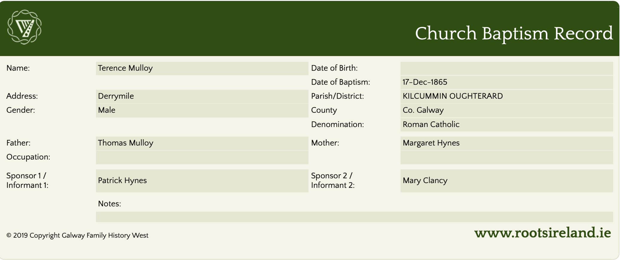
Margaret Molloy aged 78 was head of the family; a widow. She lived with her son Jerry (actually Terry, baptised in Oughterard on 17 Dec 1865) aged 45, his wife Bridget aged 37, grandchildren Thomas aged 9, Michael aged 6 & Margaret aged 3.
Margaret was a farmer’s widow. Jerry was a farmer’s son & Thomas was a scholar. Margaret Bridget & Thomas could read & write and spoke Irish & English. Jerry could not read; he spoke Irish & English. Michael & granddaughter spoke English.
Jerry & Bridget were married for 10 years; they had 3 children.
They lived in a 3rd class house with 1 room & 1 front window. They had a cow house & pig house. This was a private dwelling.
NOTE: from recent correspondence to this website, it transpires that the Jerry mentioned above it actually Terry, the error was in the transcription of the Census documentation.
http://www.census.nationalarchives.ie/pages/1911/Galway/Oughterard/Derreenmeel/912307/
House 3
Michael Kelly aged 37 was head of the family; married to Norah aged 40. They lived with their daughters Margaret aged 4, Mary aged 2 & his brother Thomas aged 27 single.
Michael was a farmer. Thomas was a farmer’s son. Michael, Norah & Thomas could read & write and spoke Irish & English.
Michael & Norah were married for 5 years; they had 2 children.
They lived in a 2nd class house with 2 rooms and 3 front windows. They had a cow house & a piggery. This was a private dwelling.
http://www.census.nationalarchives.ie/pages/1911/Galway/Oughterard/Derreenmeel/912308/
House 4
Martin Lee aged 71 was head of the family; married to Bridget aged 74. They lived with their children Norah aged 39, single & John aged 37 a widower.
Martin was a farmer. John was a farmer’s son. Martin & Bridget could not read or write. Norah & John could read & write. The entire family spoke Irish & English.
Martin & Bridget were married for 44 years; they had 7 children with 3 still living at the time of the census.
They lived in a 2nd class house with 2 rooms and 3 front windows. They had a cow house & a piggery. This was a private dwelling.
http://www.census.nationalarchives.ie/pages/1911/Galway/Oughterard/Derreenmeel/912309/
House 5
Patrick Lee aged 69 was head of the family; married to Mary aged 60. They lived with their sons Matt aged 32, Patrick aged 21, Michael aged 20, Timothy aged 15 & sister-in-law Barbara Tierney aged 46, single.
Patrick was a farmer; Matt, Patrick & Michael were farmer’s sons. Timothy was a scholar & Barbara was a domestic servant. Patrick, Matt, Patrick (son), Timothy & Barbara could read & write. Mary could not read & write. The entire family spoke Irish & English.
Patrick & Mary were married for 39 years; they had 11 children with 9 living at the time of the census.
They lived in a 2nd class house with 2 rooms and 3 front windows. This was a private dwelling.
http://www.census.nationalarchives.ie/pages/1911/Galway/Oughterard/Derreenmeel/912310/
House 6
Timothy Molloy aged 72 was head of the family; married to Bridget aged 70. They lived with their children Kate aged 46, Patrick aged 35, Margaret aged 26, Bridget aged 24 & grandchildren Bridget McGawley aged 12.
Timothy was a farmer; Patrick was a farmer’s son; Margaret was a dressmaker & Bridget was a scholar. The entire family could read & write and spoke Irish & English.
Timothy & Bridget were married for 48 years; they had 10 children with 9 still living at the time of the census.
They lived in a 2nd class house with 2 rooms and 3 front windows. They had a cow house, calf house, piggery & a barn. This was a private dwelling.
http://www.census.nationalarchives.ie/pages/1911/Galway/Oughterard/Derreenmeel/912311/
House 7
Stephen Tierney aged 51 was head of the family; married to Ellen aged 52. They lived with their children Peter aged 21, Maggie aged 18, Joseph aged 14, Maria aged 13, Bridget aged 11 & mother-in-law Margaret McGawley aged 74, a widow.
Stephen was a farmer; Peter was a farmer’s son; Maggie was a farmer’s daughter; Joseph, Maria & Bridget were scholars. Stephen & Margaret could not read. Ellen, Peter, Maggie, Joseph, Maria & Bridget could read & write. The entire family spoke Irish & English.
Stephen & Ellen were married for 26 years; they had 7 children.
They lived in a 2nd class house with 2 rooms and 3 front windows. They had a cow house, piggery & a fowl house. This was a private dwelling.
http://www.census.nationalarchives.ie/pages/1911/Galway/Oughterard/Derreenmeel/912312/
House 8
Michael Ferrick aged 55 was head of the family; married to Margaret aged 57. They lived with their sons David aged 30 & Martin aged 17, both single.
Michael was a farmer; David & Martin were farmer’s sons. Michael & Martin could read & write. Margaret & David could not read. The entire family spoke Irish & English.
Michael & Margaret were married for 31 years; they had 7 children.
They lived in a 3rd class house with 2 rooms and 2 front windows. They had a cow house & a piggery. This was a private dwelling.
http://www.census.nationalarchives.ie/pages/1911/Galway/Oughterard/Derreenmeel/912313/
House 9
Thomas Heraghty aged 75 was head of the family; a widower. He lived with his daughter Mary aged 31, single; son-in-law Patrick Kelly aged 35, a widower, grandchildren Mary Kelly aged 3 & Martin Kelly aged 2.
Thomas was a farmer; Patrick was a general labourer. Thomas could not read; he spoke only Irish. Mary could not read; she spoke Irish & English. Patrick could read & write; he spoke Irish & English.
They lived in a 3rd class house with 2 rooms and 2 front windows. They had a cow house & a piggery. This was a private dwelling.
http://www.census.nationalarchives.ie/pages/1911/Galway/Oughterard/Derreenmeel/912314/
House 10 – This house was uninhabited. It had a cow house. The landholder was Margaret McGawley.
Church records of births, deaths and marriages:
Church records of births, deaths and marriages are available online at http://www.rootsireland.ie. To search these records you will need to know the ‘church parish’ rather than the ‘civil parish’. (The civil parish is the pre-reformation parish and was frequently used as a unit of administration in the past.)
Derreenmeel is in the civil parish of Kilcummin.
Roman Catholic parishes:
This civil parish corresponds with the following Roman Catholic parish or parishes.
- Carraroe
- Kilannin
- Kilcummin/Oughterard
- Rosmuc
Church of Ireland parishes:
This civil parish corresponds with the following Church of Ireland parish.
- Kilcummin
In general, the civil parish and the Church of Ireland parish are the same, but, this is not always the case.
Maps
It is located at 53° 26′ 59″ N, 9° 20′ 15″ W
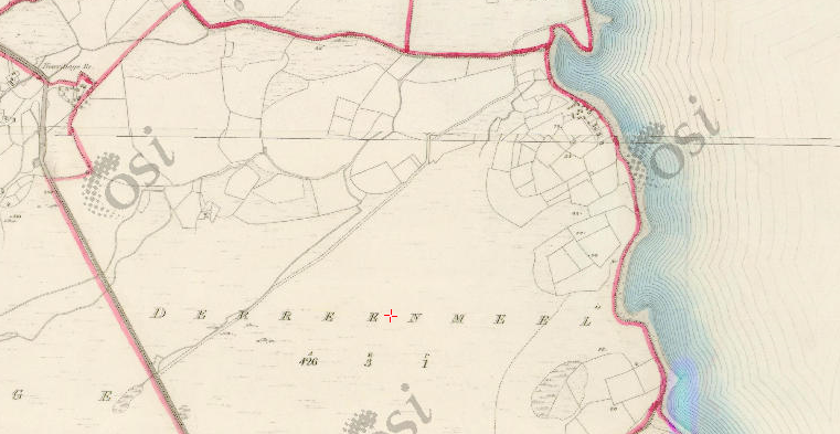
Original OS map of this area.
Ireland was first mapped in the 1840s. These original maps are available online.
Original OS maps at the Ordnance Survey of Ireland website.
Below is a link to the Ordnance Survey of Ireland website. It displays the original OS map that was created in the 1840s.
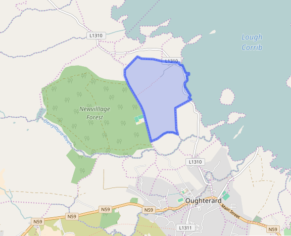
Information from Google Maps.
You can use this link to find this townland on Google Maps.
Information from the National Monuments Service.
You can use this link to view a map of archaeological features. This link brings you to a website wherein you will have to search for your townland.
Archaeological map from the National Monuments Service
Other Sources
Information from the Logainm database.
Townlands.ie Website
https://www.townlands.ie/galway/moycullen/kilcummin/oughterard/derreenmeel/
Galway Library Website
http://places.webworld.org/place/52247


No Comments
Add a comment about this page