Clynagh Island
Antoinette Lydon

Clynagh Island is in the civil parish of Kilcummin. The civil Parish corresponds with the following Church of Ireland parish of Kilcummin, Galway West. In general, the civil parish and the Church of Ireland parish are the same as is the case in the Kilcummin Oughterard area.
Clynagh Island is in the Electoral Division of Turlough, in Civil Parish of Kilcummin, in the Barony of Moycullen, in the County of Galway
Irish Form of Name: Cladhnach Island
Translation: island of the ditches
Parish: Kilcummin
View all place names in this civil parish.
Other Forms of the Name with the authority source
Clynagh Island
Cladhnach Island
Clynagh Island Local
Clynagh Island is convenient to the shore, contains 102¾ acres of rough pasture land. It has a trigonometrical station on its northern shore.
Situation:
In Rusmuc townland.
Other placenames in this townland:
Some other placenames in or near this townland are …
- Loughbegnavreaghoge (lake)
- Loughhawnaghaneekyne (lake)
- Loughmorenavreaghoge (lake)
The Tithe Applotment Books
About the Records
Tithes were a tax on agricultural produce which was payable by the occupiers of agricultural land. They were the main source of income for the parish clergy of the Church of Ireland (the largest Protestant church and the church established by law). However, in many parishes a large part of the tithes were ‘appropriate’, which meant that they were payable to a bishop, cathedral chapter or other ecclesiastical recipient, or were ‘impropriate’, which generally meant that they were payable to a local landowner. The parishes used in the Tithe Applotment Books are civil or Church of Ireland parishes, which often differ in name and territory from Catholic parishes, Acts of Parliament of 1823 and 1832 provided for the conversion of tithes into a fixed charge on land, and specified the average price of wheat or oats in the parish in the seven years before 1821 as the basis on which the tithes would be calculated. They also extended the application of tithes to pasture, where previously they had been levied only on tillage.
This change in the law resulted in the valuation of individual holdings in almost all parishes containing agricultural land, in order to assess the portion of the tithes for which each occupier of land would be liable. The apportionment was recorded for each Church of Ireland parish in a Tithe Composition Applotment Book. The information was collected and the amounts were calculated by two Parochial Commissioners, one of whom was appointed by the cess-payers of the parish and the other by the relevant Diocese of the Church of Ireland. This procedure was carried out in over 2,500 parishes between the years 1823 and 1837.
The Tithe Applotment Books are in a variety of formats, from a few pages sewn together to elaborately bound volumes. In most cases they are written in manuscript throughout, although some consist of manuscript entries on printed questionnaires. The information in the books is broadly uniform and generally includes at least the name of occupier; the size of holding, the valuation and the tithe payable. In some cases more detailed information is provided. Some volumes have maps and most have certificates and correspondence attached.
The sub-divisions of the parish were recorded. Some of these subdivisions, such as ploughlands, ceased to be in official use after the six inch survey of the Ordnance Survey was completed in the 1840s. Only productive land was subject to tithe, and the books usually distinguish between this tithable land and untithable land such as roads or mountains. Tithable land was in some cases classified by quality, and a money value was given to each class. In some cases the proportion of tithe payable to the rector, vicar or lay proprietor of the tithes was set out. The column for observations was sometimes completed, with information about commonage, for example.
There are a number of other points that should be noted. The acreages given in the Tithe Applotment Books are in Irish or Plantation measure, which is 1.62 times larger than statute measure. Only occupiers of land at the time of the tithe composition are recorded, so not all heads of households living in a parish at the time are included. Only rural areas are systematically covered, although inhabitants of towns who held plots of cultivable land are included. The equivalent tax in urban areas, Minister’s Money, has left few records.
The Tithe Applotment Books are an important source of information for a wide variety of researchers of pre-Famine Ireland. They provide the first surviving national list of the occupiers of land, and are used by genealogists as a partial substitute for returns of the 1821 and 1831 censuses of population, which were destroyed in 1922. They also record information on the quality of land, and provide information on pre-Ordnance Survey territorial divisions, some of which were not recognised after the 1840s.
The National Archives hold the original Tithe Applotment Books only for the twenty-six counties of the Republic of Ireland. The books for the six counties of Northern Ireland are held in the Public Record Office of Northern Ireland in Belfast. (http://titheapplotmentbooks.nationalarchives.ie/search/tab/aboutmore.jsp)
Tithe Applotment – Minna No Entry for Clynagh Island
Down Survey
The Down Survey is a mapped survey. Using the Civil Survey as a guide, teams of surveyors, mainly former soldiers, were sent out under Petty’s direction to measure every townland to be forfeited to soldiers and adventurers. The resulting maps, made at a scale of 40 perches to one inch (the modern equivalent of 1:50,000), were the first systematic mapping of a large area on such a scale attempted anywhere. The primary purpose of these maps was to record the boundaries of each townland and to calculate their areas with great precision. The maps are also rich in other detail showing churches, roads, rivers, castles, houses and fortifications. Most towns are represented pictorially and the cartouches, the decorative titles, of each map in many cases reflect a specific characteristic of each barony. http://downsurvey.tcd.ie/
Information from the Down Survey Website:
Townland of CLYNAGH ISLAND
Down Survey Name: Mountain
1670 Owner(s): Martin, Richard (Catholic); Clanrickard, Earl of (Protestant)
County: Galway
Barony: Muckullin
Parish: Killcumyn
The Down Survey website will tell you who owned this townland in 1641 (pre Cromwell) and in 1671 (post Cromwell).
Griffiths Valuation (1850’s)
In Griffith’s valuation the area was a total of 102 acres, 3 rood & 36 perch with a land value £10 16s 0d. No value was given for the Buildings. The total valuation was £10 16s 0d.
View the heads of households in the townland at this time;
Occupiers of the Land
Patrick Nee, Patrick Conry(Mat), Colman Nee, Patrick Donohoe, John Conry, Daniel Walsh, Patrick Cannivan, Patk. Conry (Denis), Martin Conneely & Patrick Nee (Denis).
Immediate Lessor – Directors of the Law Life Assurance Co.
http://www.askaboutireland.ie/griffith-valuation/index.xml?action=doNameSearch&PlaceID=560378
Population & Census Information
Census 1841-1911
There was no record of anyone living on Clynagh Island between 1841-1911.
People who lived here:
You can retrieve a list of people who lived in this townland from 1827 to 1911. This list is compiled from the following resources.
- The Tithe Applotment Books
- Griffith’s Valuation
- 1901 Census
- 1911 Census
List of nineteenth century and early twentieth century inhabitants.
Church records of births, deaths and marriages:
Church records of births, deaths and marriages are available online at http://www.rootsireland.ie. To search these records you will need to know the ‘church parish’ rather than the ‘civil parish’. (The civil parish is the pre-reformation parish and was frequently used as a unit of administration in the past.)
Clynagh Island is in the civil parish of Kilcummin.
Catholic parish:
This civil parish corresponds with the following Roman Catholic parish or parishes.
- Clonbern & Kilkerrin in Galway East.
- Carraroe in Galway West.
- Kilannin in Galway West.
- Kilcummin/Oughterard in Galway West.
- Rosmuc in Galway West.
Church of Ireland parish:
This civil parish corresponds with the following Church of Ireland parish.
- Kilcummin in Galway West.
In general, the civil parish and the Church of Ireland parish are the same, but, this is not always the case.
What is a townland?
A townland is one of the smallest land divisions in Ireland. They range in size from a few acres to thousands of acres. Many are Gaelic in origin, but some came into existence after the Norman invasion of 1169.
Townland information:
Clynagh Island is a townland.
Maps
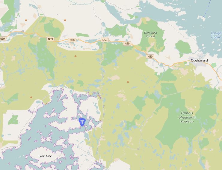
It is located at 53° 20′ 37″ N, 9° 35′ 26″ W.
Original OS map of this area
Ireland was first mapped in the 1840s. These original maps are available online.
Original OS maps at the Ordnance Survey of Ireland website
Below is a link to the Ordnance Survey of Ireland website. It displays the original OS map that was created in the 1840s.
Information from Google Maps:
You can use this link to find this townland on Google Maps.
Google Maps
http://www.townlands.ie/galway/moycullen/kilcummin/turlough/clynagh-island/
Information from the National Monuments Service:
You can use this link to view a map of archaeological features. This link brings you to a website wherein you will have to search for your townland.
Archaeological map from the National Monuments Service
Townlands.ie Website
http://www.townlands.ie/galway/moycullen/kilcummin/turlough/clynagh-island/
Galway Library Website
http://places.galwaylibrary.ie/asp/fullresult.asp?id=54246


No Comments
Add a comment about this page