Aughnanure
Townland Information
David Collins & Antoinette Lydon


Aughnanure is in the civil parish of Kilcummin. The civil parish corresponds with the following Church of Ireland parish of Kilcummin, Galway West. In general the civil parish and the Church of Ireland parish are the same as is the case in the Kilcummin Oughterard area.
Aughanure is in the Electoral Division of Oughterard, in Civil Parish of Kilcummin, in the Barony of Moycullen, in the County of Galway
Irish Form of Name: Achadh na n-Iubhar
Translation: field of the yews
Parish: Kilcummin
View all place names in this civil parish.
Other Forms of the Name with the authority source (if provided) in italics.
Aughnanure
Achadh na n-Iubhar
Aghnenewer Inquis. Temp. Car. I
Aghnanure Inq. Temp. Gul. 3
Aghnanewer Inquis. Temp. Jac. I
Aughnanure Boundary Surveyor
Augnenure Barony Cess Book
Augheranure County Map
Aughrenure Local
Aughrenure Rector of Kilcummin
Aughnanuer, the rock where the palm tree grows
Aughan – eniore Castell de Aghnenewer Inquis. Temp. Jac. I
Comment:
Castr’ et villa Aghinenure in patria coiter vocat o’Flaherties country.
Situation
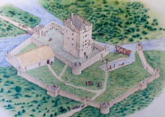
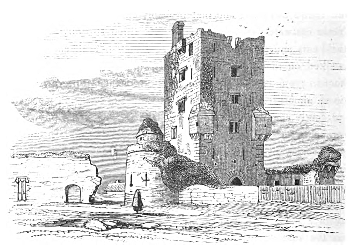
Aughnanure contains the ruins of a castle. The soil is good, but very rocky in parts. It contains 244¼ acres about 100 acres of arable land, the remainder is bog, and rough pasture. The road from Galway to Oughterard passes through the southern extremity of this townland. There is an old palm tree growing between two cliffs of the rock overhanging the river from whence that townland and castle takes their name, an old fort near the E.
Other placenames in this townland:
Some other placenames in or near this townland are
- Aughnanure Castle (castle)
A list of townlands that share a border with this townland:
This is a list of townlands that share a border with this townland.
Landlord
James O’Hara of Leanaboy House, Galway.
O’Hara (Lenaboy) – The O’Haras of Lenaboy had been established in the town of Galway since the early 18th century and members of the family held the positions of Mayor and Recorder of the town. The O’Haras of Raheen were a junior branch of this family. An entry in Burke’s ”Landed Gentry of Great Britain and Ireland” (1886) for the Martins of Ross, county Galway, suggests that the O’Haras of Lenaboy were related to the O’Haras, Lords Tyrawley and Melvin notes a reference to this in the National Library’s Report on Private Collections relating to the O’Hara family of Annaghmore. At the time of Griffith’s Valuation the O’Haras held land in the parishes of Kilcummin and Killannin, barony of Moycullen, St Nicholas, barony of Galway, Annaghdown and Kilmoylan, barony of Clare and Tuam, barony of Dunmore. In the 1870s James O’Hara owned 2,887 acres in county Galway, 239 acres in the town of Galway and 426 acres at Lawaus, parish of Crossboyne, barony of Clanmorris, in county Mayo. Over a thousand acres of the O’Hara’s county Galway property was vested in the Congested Districts’ Board on 25 Mar 1915 and an offer accepted for another 465 acres by March 1916.
Information on the owner’s family from the Landed Estates Database;
James O’Hara is a member of the O’Hara (Lenaboy) family.
Information from the Ordnance Survey Letters:
The Ordnance Survey Letters are letters between John O’Donovan and his supervisor, Thomas Larcom, regarding the work of compiling the Field Books. These letters provide further discussion on many of the places listed in the Field Books.
References to this place can be found in the following letters.
Information from the Down Survey Website:
The Down Survey website will tell you who owned this townland in 1641 (pre Cromwell) and in 1671 (post Cromwell).
The Down Survey is a mapped survey. Using the Civil Survey as a guide, teams of surveyors, mainly former soldiers, were sent out under Petty’s direction to measure every townland to be forfeited to soldiers and adventurers. The resulting maps, made at a scale of 40 perches to one inch (the modern equivalent of 1:50,000), were the first systematic mapping of a large area on such a scale attempted anywhere. The primary purpose of these maps was to record the boundaries of each townland and to calculate their areas with great precision. The maps are also rich in other detail showing churches, roads, rivers, castles, houses and fortifications. Most towns are represented pictorially and the cartouches, the decorative titles, of each map in many cases reflect a specific characteristic of each barony. (http://downsurvey.tcd.ie)
Townland of AUGHNANURE
Down Survey Name: Mountain
1670 Owner(s): Martin, Richard (Catholic); Clanrickard, Earl of (Protestant)
County: Galway
Barony: Muckullin
Parish: Killcumyn
The Tithe Applotment Books
About the Records
Tithes were a tax on agricultural produce which was payable by the occupiers of agricultural land. They were the main source of income for the parish clergy of the Church of Ireland (the largest Protestant church and the church established by law). However, in many parishes a large part of the tithes were ‘appropriate’, which meant that they were payable to a bishop, cathedral chapter or other ecclesiastical recipient, or were ‘impropriate’, which generally meant that they were payable to a local landowner. The parishes used in the Tithe Applotment Books are civil or Church of Ireland parishes, which often differ in name and territory from Catholic parishes, Acts of Parliament of 1823 and 1832 provided for the conversion of tithes into a fixed charge on land, and specified the average price of wheat or oats in the parish in the seven years before 1821 as the basis on which the tithes would be calculated. They also extended the application of tithes to pasture, where previously they had been levied only on tillage.
This change in the law resulted in the valuation of individual holdings in almost all parishes containing agricultural land, in order to assess the portion of the tithes for which each occupier of land would be liable. The apportionment was recorded for each Church of Ireland parish in a Tithe Composition Applotment Book. The information was collected and the amounts were calculated by two Parochial Commissioners, one of whom was appointed by the cess-payers of the parish and the other by the relevant Diocese of the Church of Ireland. This procedure was carried out in over 2,500 parishes between the years 1823 and 1837.
The Tithe Applotment Books are in a variety of formats, from a few pages sewn together to elaborately bound volumes. In most cases they are written in manuscript throughout, although some consist of manuscript entries on printed questionnaires. The information in the books is broadly uniform and generally includes at least the name of occupier; the size of holding, the valuation and the tithe payable. In some cases more detailed information is provided. Some volumes have maps and most have certificates and correspondence attached.
The sub-divisions of the parish were recorded. Some of these subdivisions, such as ploughlands, ceased to be in official use after the six inch survey of the Ordnance Survey was completed in the 1840s. Only productive land was subject to tithe, and the books usually distinguish between this tithable land and untithable land such as roads or mountains. Tithable land was in some cases classified by quality, and a money value was given to each class. In some cases the proportion of tithe payable to the rector, vicar or lay proprietor of the tithes was set out. The column for observations was sometimes completed, with information about commonage, for example.
There are a number of other points that should be noted. The acreages given in the Tithe Applotment Books are in Irish or Plantation measure, which is 1.62 times larger than statute measure. Only occupiers of land at the time of the tithe composition are recorded, so not all heads of households living in a parish at the time are included. Only rural areas are systematically covered, although inhabitants of towns who held plots of cultivable land are included. The equivalent tax in urban areas, Minister’s Money, has left few records.
The Tithe Applotment Books are an important source of information for a wide variety of researchers of pre-Famine Ireland. They provide the first surviving national list of the occupiers of land, and are used by genealogists as a partial substitute for returns of the 1821 and 1831 censuses of population, which were destroyed in 1922. They also record information on the quality of land, and provide information on pre-Ordnance Survey territorial divisions, some of which were not recognised after the 1840s.
The National Archives hold the original Tithe Applotment Books only for the twenty-six counties of the Republic of Ireland. The books for the six counties of Northern Ireland are held in the Public Record Office of Northern Ireland in Belfast. (http://titheapplotmentbooks.nationalarchives.ie/search/tab/aboutmore.jsp)
Tithe Applotment Aughnanure 1829
James McKeoan & John Thomas had 140 acres of land; 14 acres of 1st quality of land with a payment of 1s 6d, 10 acres of 2nd quality land with a payment of 1s, 30 acres of 3rd quality land with a payment of 3d, 46 acres of 4th quality land with a payment of ½d and 40 acres of 5th quality land with a payment of ⅛d.
The Tithe payments went to Richard Martin Esq and the Reverends James Daly & John Wilson.
http://titheapplotmentbooks.nationalarchives.ie/reels/tab//004587459/004587459_00441.pdf
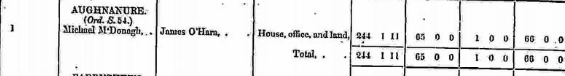
Griffith’s Valuation 1850s
In Griffith’s valuation the area was 244 acres, 1 rood & 11 perch with a land value £65 0s 0d. Value of Buildings was £1 0s & 0d. Total valuation of £66 0s 0d.
Occupier: Michael McDonagh
Immediate Lessor: James O’Hara
http://www.askaboutireland.ie/griffith-valuation/index.xml?action=doNameSearch&PlaceID=559629
Out Offices and Land
The out office was a farm building, a cow house, piggery or barn. The land was very poor and sterile and people were always poverty-stricken. At this time most tenants were trying to eke out a living on 5 acres or less and a farmer needed at least 15.3 acres to survive.
Poor Law Union Ireland
In Ireland the Poor Relief Act of 1838 divided into districts or “unions” in which the local taxable inhabitants were to be financially responsible for all paupers in the area. In 1898 the Poor Law Union was adopted as the basic administrative division in place of the civil parish and barony. Further subdivision into 828 registration districts and 3,751 district electoral divisions followed. Townlands were not arranged according to these divisions with parish and barony retained as a means to make comparisons with records gathered before 1898.
The 1838 Act
The main provisions of the 1838 Act were:
- The extension of the existing Poor Law Commissioners’ powers to Ireland, with the appointment of Assistant Commissioners who were to implement the Act in Ireland.
- The division of the country into Poor Law Unions based on Irish electoral divisions which were they made up from townlands.
- The creation of a Board of Guardians for each Union, two-thirds of whom were to be elected, the other third to be appointed ex officio.
- The setting up of a workhouse in each Union.
- The collection of a local poor-rate to finance the system.
- Assistance for emigration.
Initially, 130 Unions were created, based upon 2,049 electoral divisions. The divisions were composed of townlands, a peculiarly Irish unit, traditionally of 120 Irish acres in area. (Between 1848 and 1850, an additional 33 Unions were created by subdividing and reorganizing the boundaries of some existing Unions, particularly in the west of the country.
Boards of Guardians were elected annually on 25th March. Only rate-payers were eligible for election, which effectively disenfranchised most of the native Irish who were usually tenants at this time. Rate-payers were allowed between one and six votes depending on the size of a valuation of their property.
What is a townland?
A townland is one of the smallest land divisions in Ireland. They range in size from a few acres to thousands of acres. Many are Gaelic in origin, but some came into existence after the Norman invasion of 1169. Aughnanure is a townland.
Population and Census Information
People who lived here:
You can retrieve a list of people who lived in this townland from 1827 to 1911. This list is compiled from the following resources.
- The Tithe Applotment Books
- Griffith’s Valuation
- 1901 Census
- 1911 Census
List of nineteenth century and early twentieth century inhabitants.
Census 1841-1891
1841 – 15 houses with 75 people
1851 – 2 houses with 19 people
1861 – 5 houses with 24 people
1871 – 6 houses with 21 people
1881 – 4 houses (4 inhabited) with 21 people (10 males / 11 females). There were 4 outbuildings. Total Valuation of Houses & Lands £66 0s 0d.
1891 – 5 houses (5 inhabited) with 28 people (15 males / 13 females). There were 8 Outbuildings. Total Valuation of Houses & Lands £66 0s 0d.
Census 1901 Aughnanure
This is a return of the member of the family, their Visitors, Boarders, and Servants who slept or abode in their house on the night of 31st of March 1901 in Aughnanure. There were 3 houses listed in the townland of Aughnanure. 14 (6 females/ 8 males) were all Roman Catholics. The townland had 7 outbuildings. The people that lived in Aughnanure were born in Co. Galway.
Enumerators Extract
http://www.census.nationalarchives.ie/reels/nai000840532/
House & Building Returns
http://www.census.nationalarchives.ie/reels/nai000840533/
Out Offices & Farm Steadings
http://www.census.nationalarchives.ie/reels/nai000840534/
House 1
Thomas Connor aged 79 was head of the family; married to Sarah aged 60. They lived with their grandsons Daniel Folan aged 14 & Thomas Folan aged 12.
Thomas Connor was a herd, Daniel a farm labourer & Thomas Folan was a scholar. Thomas & Sarah Connor could not read, Daniel & Thomas could read. The entire family spoke Irish & English.
They lived in a 3rd class house with 2 rooms and 2 front windows. They had a cow house.
http://www.census.nationalarchives.ie/pages/1901/Galway/Oughterard/Aughnanure/1394536/
House 2
Mary Davoran aged 72 was head of the family; a widow. She lived with her granddaughter Kate Connor aged 10.
Mary was a farmer and Kate was a scholar. Mary could read and spoke Irish & English. Kate could read & write.
They lived in a 3rd class house with 2 rooms and no front window. They had a cow house & a piggery.
http://www.census.nationalarchives.ie/pages/1901/Galway/Oughterard/Aughnanure/1394537/
House 3
Michael Connor aged 44 was head of the family; married to Bridget aged 38. They lived with their children Thomas aged 20, Michael aged 16, Bridget aged 11, Monica aged 8, John aged 5 & Andrew aged 2.
Michael was a herd, Bridget was a housekeeper, Thomas was a farm labourer, Michael, Bridget & Monica were scholars. Michael (father) could not read, he spoke Irish & English. John & Andrew could not read. Bridget, Thomas, Michael, Bridget & Monica could read and write & spoke Irish & English.
They lived in a 3rd class house with 2 rooms and 1 front window. They had a cow house, calf house, piggery & a fowl house.
http://www.census.nationalarchives.ie/pages/1901/Galway/Oughterard/Aughnanure/1394538/
1911 Census Aughnanure
This is a return of the Members of the families in Aughnanure, their visitors, boarders and servants who slept or abode in the house on the night of Sunday 2nd April 1911.
There were 8 houses listed in the Townland of Aughnanure. A total of 12 (10 males/14 females) living in Aughnanure all were Roman Catholic.
People that lived in Aughnanure were born included Co. Galway. There were a total of 12 farm buildings and out offices which included cow houses, piggeries, fowl house & a barn.
Enumerators Extract
http://www.census.nationalarchives.ie/reels/nai002435166/
House & Building Return
http://www.census.nationalarchives.ie/reels/nai002435168/
Out Offices & Farm Steadings
http://www.census.nationalarchives.ie/reels/nai002435170/
House 1
Thomas Curley aged 69 was head of the family, married to Ellen aged 61; they lived with their children Timothy aged 20 & Ellen aged 16.
Thomas & Timothy were labourers & Ellen was a scholar. Thomas could not read. Ellen (mother), Timothy & Ellen could read & write. The entire family spoke Irish & English.
They lived in a 3rd class house with 2 rooms and 1 front window. They had a cow house & a piggery.
http://www.census.nationalarchives.ie/pages/1911/Galway/Oughterard/Aughnanure/912224/
House 2
Michéal O Conchubair aged 60, he lived with Brighid aged 50, Michéal aged 25, Muineaca aged 18, Seagan aged 15, Aindremh aged 13, Eibhilén aged 10 & Donhnail O Cumhláin aged 24.
They lived in a 3rd class house with 3 rooms and 1 front window. They had a cow house, piggery, fowl house & a barn.
http://www.census.nationalarchives.ie/pages/1911/Galway/Oughterard/Aughnanure/912225/
Church records of births, deaths and marriages:
Church records of births, deaths and marriages are available online at http://www.rootsireland.ie. To search these records you will need to know the ‘church parish’ rather than the ‘civil parish’. (The civil parish is the pre-reformation parish and was frequently used as a unit of administration in the past.)
Aughnanure is in the civil parish of Kilcummin.
Catholic parish:
This civil parish corresponds with the following Roman Catholic parish or parishes.
- Clonbern & Kilkerrin in Galway East.
- Carraroe in Galway West.
- Kilannin in Galway West.
- Kilcummin/Oughterard in Galway West.
- Rosmuc in Galway West.
Church of Ireland parish:
This civil parish corresponds with the following Church of Ireland parish.
- Kilcummin in Galway West.
In general, the civil parish and the Church of Ireland parish are the same, but, this is not always the case.
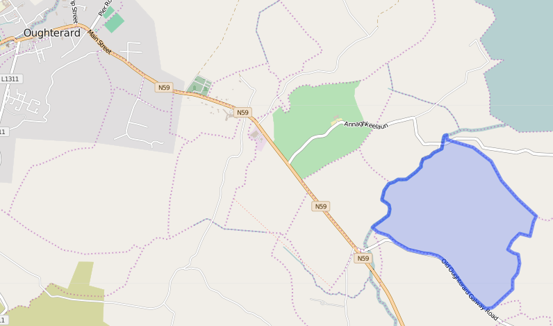
Map
It is located at 53° 24′ 51″ N, 9° 16′ 19″ W.
Original OS map of this area
Ireland was first mapped in the 1840s. These original maps are available online.
Original OS maps at the Ordnance Survey of Ireland website
Below is a link to the Ordnance Survey of Ireland website. It displays the original OS map that was created in the 1840s.
Information from Google Maps:
You can use this link to find this townland on Google Maps.
Information from the National Monuments Service:
You can use this link to view a map of archaeological features. This link brings you to a website wherein you will have to search for your townland.
Archaeological map from the National Monuments Service
Townlands.ie Website
http://www.townlands.ie/galway/moycullen/kilcummin/oughterard/aughanure/
Galway Library Website
http://places.webworld.org/place/51893


No Comments
Add a comment about this page